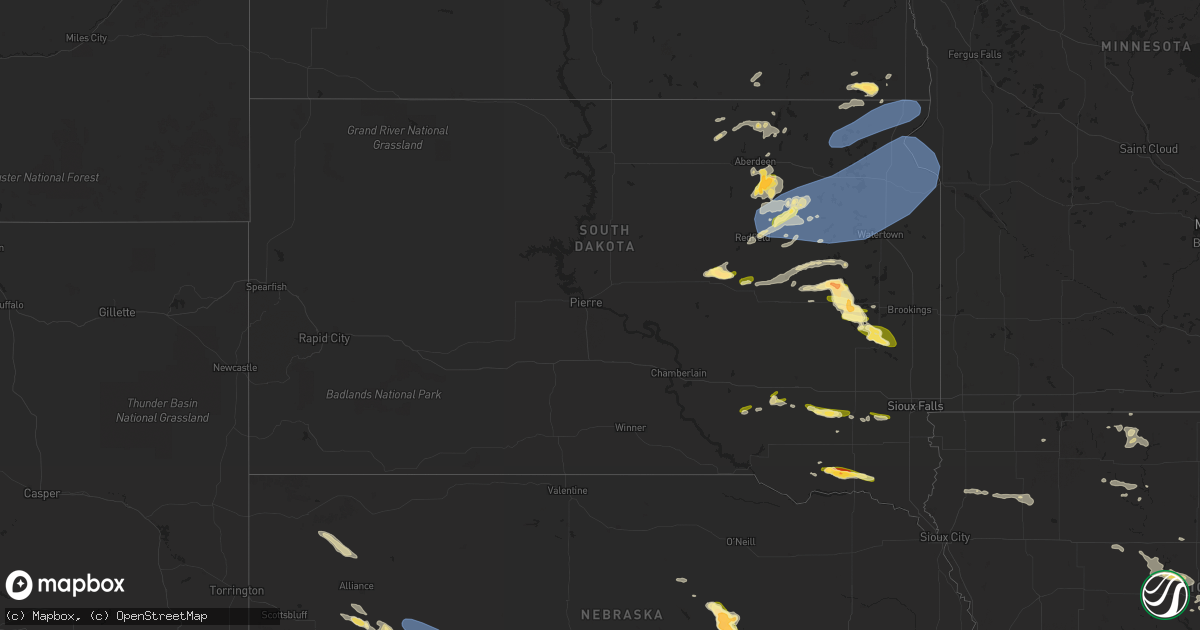
Hail Map in South Dakota on August 10, 2023
Get this storm
August 10 map
$229
one time, instant access
Download today. No call, no setup
Keep the $229
Bought the map and want the full workflow? Apply the entire $229 to a subscription within 7 days. None of it is wasted.
Every map, not just this one
This buys you this map. Subscription and you get every map we run, in the markets you choose from a few cities to whole states to nationwide. Plus real-time alerts the moment a storm fires.
Contact data
Name, contact info, occupancy, even credit band for addresses in the footprint. You go from where it hit to who to call.
Become the source they trust
Unlimited branding weather history reports on demand. You already have the documented answer ready for the property owner, and you are the one who showed up with it.
Property data and RoofTrace estimates
Pull up any address you have got, its value and the exact code rules for that jurisdiction, straight from One Click Code. Then RoofTrace estimates the squares, pitch, and roof value, priced the way you price.
Storm reports in South Dakota
South Dakota
| Date | Description |
|---|---|
| 08/10/20236:46 PM CDT | A local report indicates 60 MPH wind near Lake City |
| 08/10/20236:45 PM CDT | Scattered damage to cornfield. Spotter estimated the wind speed had be greater that 50 mph. Time estimated based on radar. |
| 08/10/20236:43 PM CDT | Pea to quarter sized hail... But mostly quarter sized. |
| 08/10/20236:35 PM CDT | Report from mping: quarter |
| 08/10/20236:35 PM CDT | A local report indicates 65 MPH wind near 3 WNW Roy Lake State Pa |
| 08/10/20236:09 PM CDT | Turs2. |
| 08/10/20235:57 PM CDT | Mesonet station 306 3s conde |
| 08/10/20235:48 PM CDT | Report and photo via social media. Largest stone quarter sized. Time estimated via radar. |
| 08/10/20235:46 PM CDT | A local report indicates 1.00 inch wind near 7 NNW Harrison |
| 08/10/20235:25 PM CDT | A lot of quarter-sized to golfball-sized hail. Ground is completely white from the hail. |
| 08/10/20234:45 PM CDT | A local report indicates 1.75 inch wind near 3 ESE Warner |
| 08/10/20234:40 PM CDT | Property blown off patio. Pea-sized hail. 1.50 inch of rain in appx 30 minutes. |
| 08/09/20239:06 PM CDT | A local report indicates 1.00 inch wind near 3 NNE Madison |
| 08/09/20239:04 PM CDT | Public report of quarter to half dollar sized hail. Time estimated by radar. |
| 08/09/20238:46 PM CDT | A local report indicates 1.75 inch wind near Lesterville |
| 08/09/20238:44 PM CDT | A local report indicates 1.25 inch wind near 2 E Ramona |
| 08/09/20238:15 PM CDT | Kingsbury em called to report tornado on the ground following 200th st... Approximately 4 east of 441st ave. |
| 08/09/20238:10 PM CDT | Video of tornado via social media. |
| 08/09/20238:01 PM CDT | Report via social media. Time and location estimated by radar. |
| 08/09/20237:54 PM CDT | Chaser was 1 n of bryant looking north at time of report. |
| 08/09/20237:48 PM CDT | Report relayed through desmet fire... Public reported tornado on the ground. |
| 08/09/20237:47 PM CDT | A local report indicates a tornado near 4 NW Bryant |
| 08/09/20237:46 PM CDT | Doors blown off barn. |
| 08/09/20237:45 PM CDT | Em for kingsbury county called to report 1 inch hail. |
| 08/09/20237:38 PM CDT | Time estimated via radar. |
| 08/09/20237:15 PM CDT | Time estimated by radar. At least 3 trees down. Branch impaled side of house. |
| 08/09/20237:11 PM CDT | Mesonet station 174 clark |
| 08/09/20237:10 PM CDT | Heavy wooden trailer with a water tank on it moved appx 150 yards... Through two ditches... And hit neighbors house. |
All States Impacted by Hail Map on August 10, 2023
Cities Impacted by Hail Map on August 10, 2023
- Walnut Ridge, AR
- Portia, AR
- Hoxie, AR
- Bono, AR
- Jonesboro, AR
- North Tonawanda, NY
- Niagara Falls, NY
- Sanborn, NY
- Lockport, NY
- Buffalo, NY
- Supply, NC
- North Rim, AZ
- Granite Canon, WY
- Tie Siding, WY
- Livermore, CO
- Wellington, CO
- Carr, CO
- Ault, CO
- Nunn, CO
- Grover, CO
- Briggsdale, CO
- New Raymer, CO
- Orchard, CO
- Weldona, CO
- Fort Morgan, CO
- Eaton, CO
- Galeton, CO
- Pierce, CO
- Roby, TX
- Sweetwater, TX
- Dix, NE
- Potter, NE
- Sidney, NE
- Miller, SD
- Saint Lawrence, SD
- Wessington, SD
- Kearney, NE
- Gibbon, NE
- Lodgepole, NE
- Stickney, SD
- Ashton, SD
- Turton, SD
- Frankfort, SD
- Doland, SD
- Conde, SD
- Raymond, SD
- Redfield, SD
- Clark, SD
- Garden City, SD
- Bristol, SD
- Bradley, SD
- Mellette, SD
- Andover, SD
- Webster, SD
- Brentford, SD
- Hitchcock, SD
- Wolsey, SD
- Watertown, SD
- Wallace, SD
- Florence, SD
- Waubay, SD
- Henry, SD
- Bowbells, ND
- Saint Johns, AZ
- Osteen, FL
- Oak Hill, FL
- Orlando, FL
- Minden, NE
- Kenesaw, NE
- Shelton, NE
- Snowflake, AZ
- Portal, ND
- Flaxton, ND
- Leupp, AZ
- Aragon, NM
- Burwell, NE
- Bronte, TX
- Clarkdale, AZ
- Columbus, ND
- Holly Ridge, NC
- Sneads Ferry, NC
- Almena, KS
- Long Island, KS
- Juniata, NE
- Mount Vernon, SD
- Ethan, SD
- Hastings, NE
- Roseland, NE
- Ayr, NE
- Ericson, NE
- Britton, SD
- Eden, SD
- Langford, SD
- Roslyn, SD
- Lake City, SD
- Sisseton, SD
- Veblen, SD
- Claire City, SD
- New Effington, SD
- Rosholt, SD
- Hankinson, ND
- Glenvil, NE
- Mohall, ND
- Lansford, ND
- Glenburn, ND
- Minot Afb, ND
- Berthold, ND
- Minot, ND
- Blue Hill, NE
- Carpio, ND
- Norwich, ND
- Surrey, ND
- Summit, SD
- Peever, SD
- South Shore, SD
- Ortley, SD
- Marvin, SD
- Wilmot, SD
- Strandburg, SD
- Twin Brooks, SD
- Stockholm, SD
- Big Stone City, SD
- Milbank, SD
- Labolt, SD
- Corona, SD
- Grenville, SD
- Ord, NE
- Scotia, NE
- Alexandria, SD
- Parkston, SD
- Emery, SD
- Beardsley, MN
- Ortonville, MN
- Browns Valley, MN
- Barry, MN
- Graceville, MN
- Clinton, MN
- Lawrence, NE
- De Smet, SD
- Lake Preston, SD
- Freeman, SD
- Bridgewater, SD
- Chappell, NE
- Bowie, TX
- Bellevue, TX
- Seymour, TX
- Ellsworth, NE
- Oshkosh, NE
- Lewellen, NE
- Ashby, NE
- Arthur, NE
- Sutherland, NE
- North Platte, NE
- Tryon, NE
- Hershey, NE
- Guide Rock, NE
- Nelson, NE
- Superior, NE
- Hardy, NE
- Webber, KS
- Republic, KS
- Courtland, KS
- Belleville, KS
- Monroe, SD
- Parker, SD
- Electra, TX
- Iowa Park, TX
- Crowell, TX
- Wichita Falls, TX
- Tyndall, SD
- Scotland, SD
- Lesterville, SD
- Utica, SD
- Yankton, SD
- Mission Hill, SD
- Volin, SD
- Chancellor, SD
- Greeley, NE
- Lemoyne, NE
- Paxton, NE
- Keystone, NE
- Scandia, KS
- Henrietta, TX
- Sheppard Afb, TX
- Oak, NE
- Cayuga, ND
- Lidgerwood, ND
- Oldham, SD
- Ramona, SD
- Madison, SD
- Hecla, SD
- Frederick, SD
- Barnard, SD
- Ovalo, TX
- Hamlin, TX
- Bridgeport, NE
- Marion, SD
- Haskell, TX
- Trent, TX
- Iroquois, SD
- Houghton, SD
- Fullerton, ND
- Ellendale, ND
- Leola, SD
- Westport, SD
- Butte, ND
- Turtle Lake, ND
- Ballinger, TX
- Rowena, TX
- Aberdeen, SD
- Bryant, SD
- Willow Lake, SD
- Ruso, ND
- Mercer, ND
- Harrison, SD
- Jacksboro, TX
- Angora, NE
- Merkel, TX
- Tolley, ND
- Olney, TX
- Windthorst, TX
- Holliday, TX
- Columbia, SD
- Concho, AZ
- Abilene, TX
- Winslow, AZ
- Yale, SD
- Alliance, NE
- Hemingford, NE
- Crawford, NE
- Marsland, NE
- Tabor, SD
- Warner, SD
- Stratford, SD
- Hermleigh, TX
- Snyder, TX
- Montague, TX
- San Angelo, TX
- Kenmare, ND
- Bath, SD
- Lisco, NE
- Voltaire, ND
- Rutland, ND
- Havana, ND
- Forestburg, TX
- Tulare, SD
- Baird, TX
- Cross Plains, TX
- Bladen, NE
- Erwin, SD
- Huron, SD
- Sunset, TX
- Carpenter, SD
- Jayton, TX
- Kimball, NE
- Broadwater, NE
- Newcastle, TX
- Loving, TX
- Graham, TX
- Milnor, ND
- Donnybrook, ND
- Bartlett, NE
- Fairfield, NE
- Maryneal, TX
- Rotan, TX
- Tuscola, TX
- Norton, TX
- Robert Lee, TX
- Deweese, NE
- Mansfield, SD
- Winters, TX
- Groton, SD
- Pinon, AZ
- Concordia, KS
- Saint Jo, TX
- Stamford, TX
- Nolan, TX
- Mertzon, TX
- Elm Creek, NE
- Clyde, TX
- Nunda, SD
- Wentworth, SD
- Rutland, SD
- Prague, OK
- Seminole, OK
- Earlsboro, OK
- Paden, OK
- Dustin, OK
- Weleetka, OK
- Eufaula, OK
- Hanna, OK
- Henryetta, OK
- Boley, OK
- Checotah, OK
- Mcalester, OK
- Quinton, OK
- Porum, OK
- Webbers Falls, OK
- Stigler, OK
- Vian, OK
- Sallisaw, OK
- Keota, OK
- Wood River, NE
- Gans, OK
- Muldrow, OK
- Mcclusky, ND
- Somers, IA
- Rutland, IA
- Winterset, IA
- Wewoka, OK
- Rockwell City, IA
- Harcourt, IA
- Dayton, IA
- Armstrong, IA
- Fenton, IA
- Swea City, IA
- Bancroft, IA
- Lone Rock, IA
- Okemah, OK
- Castle, OK
- Livermore, IA
- Tingley, IA
- Remsen, IA
- Cleghorn, IA
- Marcus, IA
- Cherokee, IA
- Aurelia, IA
- Meriden, IA
- Meeker, OK
- Wetumka, OK
- Adrian, MN
- Calvin, OK
- Burt, IA
- Winfield, AL
- Fayette, AL
- Marietta, MN
- Estherville, IA
- Ogden, IA
- Pilot Mound, IA
- Mallard, IA
- Mcloud, OK
- Boone, IA
- Lake Crystal, MN
- Amboy, MN
- West Bend, IA
- Holdenville, OK
- Bradgate, IA
- Rolfe, IA
- Ottosen, IA
- Bode, IA
- Le Mars, IA
- Albany, TX
- Porter, MN
- Lamar, OK
- Canby, MN
- Olivet, SD
- Ogdensburg, NY
- Maud, OK
- Madelia, MN
- Crowder, OK
- Indianola, OK
- Eldridge, AL
- Garden City, MN
- Alma, AR
- Lavaca, AR
- Shawnee, OK
- Everly, IA
- Guin, AL
- Vernon Center, MN
- Okmulgee, OK
- Sparks, OK
- Ivanhoe, MN
- Sylvester, TX
- New Richland, MN
- Madrid, IA
- Slater, IA
- Bessemer, AL
- Minnesota Lake, MN
- Wells, MN
- Berry, AL
- Bankston, AL
- Waterloo, IA
- Evansdale, IA
- Janesville, IA
- Waverly, IA
- Shell Rock, IA
- Centerville, IA
- Arlington, SD
- Charleston, AR
- Maxwell, IA
- Nevada, IA
- Collins, IA
- Richland, IA
- Bondurant, IA
- Mitchellville, IA
- Warner, OK
- Kelley, IA
- Ames, IA
- Adger, AL
- Brookwood, AL
- Downing, MO
- Lancaster, MO
- Nashua, IA
- Charles City, IA
- Dysart, IA
- La Porte City, IA
- Buckingham, IA
- Traer, IA
- Elkhart, IA
- Newton, IA
- Baxter, IA
- Ira, IA
- Cambridge, IA
- Mingo, IA
- Rhodes, IA
- Colfax, IA
- Prairie City, IA
- Monroe, IA
- Iowa Falls, IA
- Stratford, IA
- Birmingham, AL
- Searsboro, IA
- Barnes City, IA
- New Sharon, IA
- Montezuma, IA
- Taylor Ridge, IL
- Montevallo, AL
- Calera, AL
- Callender, IA
- Oktaha, OK
- Muskogee, OK
- Pocola, OK
- Grinnell, IA
- Lynnville, IA
- Cedar Falls, IA
- Muscatine, IA
- Illinois City, IL
- Stockton, IA
- Blue Grass, IA
- Reinbeck, IA
- Rose Hill, IA
- What Cheer, IA
- Huntington, AR
- Mansfield, AR
- Wadley, AL
- Daviston, AL
- Deep River, IA
- Sully, IA
- Reasnor, IA
- Delta, IA
- Gibson, IA
- Malcom, IA
- Pella, IA
- Kellogg, IA
- Stuart, OK
- Oakman, AL
- Northport, AL
- Lineville, AL
- Wedowee, AL
- Paris, AR
- Clarksville, IA
- Allison, IA
- Story City, IA
- Gowrie, IA
- Fort Dodge, IA
- Paton, IA
- Lehigh, IA
- Boxholm, IA
- Coatsville, MO
- Pelham, AL
- Fultondale, AL
- Trussville, AL
- Gardendale, AL
- Huxley, IA
- Ratcliff, AR
- Independence, IA
- Hazleton, IA
- Columbiana, AL
- New Hartford, IA
- Denver, IA
- Unionville, MO
- Moulton, IA
- Bloomfield, IA
- Livonia, MO
- Exline, IA
- Hartland, MN
- West Fork, AR
- Spiro, OK
- Stout, IA
- Parkersburg, IA
- Dike, IA
- Fairfield, IA
- Keota, IA
- Sigourney, IA
- Ollie, IA
- Hackett, AR
- Fort Smith, AR
- Greenwood, AR
- Cameron, OK
- Helena, AL
- Altoona, IA
- Aplington, IA
- Ozark, AR
- Cecil, AR
- Ringsted, IA
- Diagonal, IA
- Booneville, AR
- Magazine, AR
- Branch, AR
- Council Hill, OK
- Webster City, IA
- Sherrard, IL
- Reynolds, IL
- Matherville, IL
- Aledo, IL
- Mount Pleasant, IA
- Wayland, IA
- Garden City, KS
- Sylacauga, AL
- Milan, IL
- Leoti, KS
- Scott City, KS
- Marienthal, KS
- Holcomb, KS
- Brighton, IA
- Lockridge, IA
- Shelby, AL
- Vienna, SD
- Cragford, AL
- Andalusia, IL
- Buffalo, IA
- Montpelier, IA
- Durant, IA
- Gilson, IL
- Knoxville, IL
- Galesburg, IL
- Memphis, MO
- Oneida, IL
- Roanoke, AL
- Five Points, AL
- Jemison, AL
- Alabaster, AL
- Packwood, IA
- Chelsea, AL
- Lafayette, AL
- Mickleton, NJ
- Browns Mills, NJ


