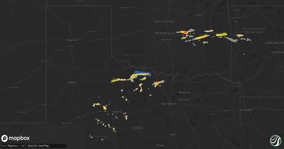
Hail Map on August 10, 2023
Get this storm
August 10 map
$229
one time, instant access
Download today. No call, no setup
Keep the $229
Bought the map and want the full workflow? Apply the entire $229 to a subscription within 7 days. None of it is wasted.
Every map, not just this one
This buys you this map. Subscription and you get every map we run, in the markets you choose from a few cities to whole states to nationwide. Plus real-time alerts the moment a storm fires.
Contact data
Name, contact info, occupancy, even credit band for addresses in the footprint. You go from where it hit to who to call.
Become the source they trust
Unlimited branding weather history reports on demand. You already have the documented answer ready for the property owner, and you are the one who showed up with it.
Property data and RoofTrace estimates
Pull up any address you have got, its value and the exact code rules for that jurisdiction, straight from One Click Code. Then RoofTrace estimates the squares, pitch, and roof value, priced the way you price.
States Impacted by Hail Map on August 10, 2023
Storm reports
Nebraska
| Date | Description |
|---|---|
| 08/10/20236:50 PM CDT | A local report indicates 1.25 inch wind near 13 NW Ericson |
| 08/10/20235:45 PM CDT | A local report indicates 62 MPH wind near 3 SE Sidney |
| 08/10/20235:40 PM CDT | Nickel size hail with some quarters mixed in. |
| 08/10/20235:35 PM CDT | A local report indicates 67 MPH wind near Sidney |
| 08/10/20235:35 PM CDT | 7 inch diameter tree limb down. |
| 08/10/20235:34 PM CDT | A local report indicates 1.00 inch wind near 1 W Sidney |
| 08/10/20235:25 PM CDT | Report with photo from social media. Time estimated from radar. |
| 08/10/20235:25 PM CDT | Mostly dime to nickel size hail with a few quarters. |
| 08/10/20235:25 PM CDT | Em report of quarter size hail in parts of kearney. |
| 08/10/20235:20 PM CDT | Half dollar |
| 08/10/20235:18 PM CDT | Delayed report via social media of hail at least half dollar size south of riverdale. Time estimated based on radar. |
| 08/10/20235:18 PM CDT | Social media report with photo of hail northwest of kearney relayed from emergency manager. Location is approximated from radar. |
| 08/09/20239:10 PM CDT | A local report indicates 67 MPH wind near 1 NW Sutherland |
| 08/09/20238:47 PM CDT | A local report indicates 1.50 inch wind near 6 NNE Bostwick |
| 08/09/20238:43 PM CDT | Em passed public report from picture on social media. |
| 08/09/20238:40 PM CDT | Public report. Estimated 60 mph winds. |
| 08/09/20238:35 PM CDT | Fire department in nuckolls county reports golf ball to tennis ball sized hail near the junction of highways 136 and 14. Time estimated based on radar. |
| 08/09/20238:18 PM CDT | Social media report of egg size hail southeast of lawrence. Time estimated from radar. |
| 08/09/20238:18 PM CDT | Emergency manager reported quarter to golf ball sized hail near roads 3100 and l. Time estimated based on radar. |
| 08/09/20238:13 PM CDT | Social media report of ping pong ball size hail south of lawrence. |
| 08/09/20238:12 PM CDT | Delayed report via social media of hail slightly larger than golf balls. Time estimated based on radar. |
| 08/09/20238:07 PM CDT | Social media report of ping pong ball size hail. Time estimated from radar. |
| 08/09/20237:45 PM CDT | Time estimated from radar. Pictures sent via social media. |
| 08/09/20237:45 PM CDT | Time estimated from radar. |
| 08/09/20237:45 PM CDT | Public report of 1.5 to 2 inch hail based on measurements. |
| 08/09/20237:38 PM CDT | Delayed report via social media report of damage to a corn field due to hail and wind. Hail size estimated to be around nickel to quarter. Time estimated based on radar |
| 08/09/20237:35 PM CDT | A local report indicates 65 MPH wind near Crescent Lake Nwr |
| 08/09/20237:30 PM CDT | Report with photo of golf ball sized hail near ayr. |
| 08/09/20237:15 PM CDT | Corrects previous hail report from 13 wnw ericson. Em passed public report from picture on social media. |
| 08/09/20237:15 PM CDT | Report relayed by em of baseball size hail. Time estimated from radar. |
South Dakota
| Date | Description |
|---|---|
| 08/10/20236:46 PM CDT | A local report indicates 60 MPH wind near Lake City |
| 08/10/20236:45 PM CDT | Scattered damage to cornfield. Spotter estimated the wind speed had be greater that 50 mph. Time estimated based on radar. |
| 08/10/20236:43 PM CDT | Pea to quarter sized hail... But mostly quarter sized. |
| 08/10/20236:35 PM CDT | Report from mping: quarter |
| 08/10/20236:35 PM CDT | A local report indicates 65 MPH wind near 3 WNW Roy Lake State Pa |
| 08/10/20236:09 PM CDT | Turs2. |
| 08/10/20235:57 PM CDT | Mesonet station 306 3s conde |
| 08/10/20235:48 PM CDT | Report and photo via social media. Largest stone quarter sized. Time estimated via radar. |
| 08/10/20235:46 PM CDT | A local report indicates 1.00 inch wind near 7 NNW Harrison |
| 08/10/20235:25 PM CDT | A lot of quarter-sized to golfball-sized hail. Ground is completely white from the hail. |
| 08/10/20234:45 PM CDT | A local report indicates 1.75 inch wind near 3 ESE Warner |
| 08/10/20234:40 PM CDT | Property blown off patio. Pea-sized hail. 1.50 inch of rain in appx 30 minutes. |
| 08/09/20239:06 PM CDT | A local report indicates 1.00 inch wind near 3 NNE Madison |
| 08/09/20239:04 PM CDT | Public report of quarter to half dollar sized hail. Time estimated by radar. |
| 08/09/20238:46 PM CDT | A local report indicates 1.75 inch wind near Lesterville |
| 08/09/20238:44 PM CDT | A local report indicates 1.25 inch wind near 2 E Ramona |
| 08/09/20238:15 PM CDT | Kingsbury em called to report tornado on the ground following 200th st... Approximately 4 east of 441st ave. |
| 08/09/20238:10 PM CDT | Video of tornado via social media. |
| 08/09/20238:01 PM CDT | Report via social media. Time and location estimated by radar. |
| 08/09/20237:54 PM CDT | Chaser was 1 n of bryant looking north at time of report. |
| 08/09/20237:48 PM CDT | Report relayed through desmet fire... Public reported tornado on the ground. |
| 08/09/20237:47 PM CDT | A local report indicates a tornado near 4 NW Bryant |
| 08/09/20237:46 PM CDT | Doors blown off barn. |
| 08/09/20237:45 PM CDT | Em for kingsbury county called to report 1 inch hail. |
| 08/09/20237:38 PM CDT | Time estimated via radar. |
| 08/09/20237:15 PM CDT | Time estimated by radar. At least 3 trees down. Branch impaled side of house. |
| 08/09/20237:11 PM CDT | Mesonet station 174 clark |
| 08/09/20237:10 PM CDT | Heavy wooden trailer with a water tank on it moved appx 150 yards... Through two ditches... And hit neighbors house. |
Minnesota
| Date | Description |
|---|---|
| 08/09/202311:48 PM CDT | Delayed report - dispatch reported tree down on highway. Time estimated from radar. |
| 08/09/202311:10 PM CDT | Dispatch relayed report of tree down in the city of new ulm. |
| 08/09/202310:01 PM CDT | Delayed report - trees down and powerlines down north of spicer. Time estimated from radar. |
New Jersey
| Date | Description |
|---|---|
| 08/10/20232:46 PM CDT | Photo of trees down across sun tavern road in millstone. Road is closed. Time estimated from radar. |
| 08/10/20232:11 PM CDT | Report of trees down at the intersection of range rd and n white bogs rd... Off of ridge road. Time estimated from radar. |
| 08/10/20232:11 PM CDT | Received photos of trees down on n whites bogs rd. Time estimated from radar. |
| 08/10/20232:10 PM CDT | Trees and wires down at the intersection of ridge road and huberta street. Time estimated from radar. |
| 08/10/20232:10 PM CDT | Received several photos from the public of trees snapped on margaret street. Time estimated. |
| 08/10/20232:08 PM CDT | Tornado damage was noted at residences along margaret street. This matches with a security camera at a residence that showed the condensation funnel of a tornado moving |
| 08/10/20231:35 PM CDT | Powerlines down on center street in haddon twp. Time estimated from radar. |
| 08/10/20231:33 PM CDT | Powerlines down on cuthbert rd in haddon twp. Time estimated from radar. |
| 08/10/20231:31 PM CDT | Tree down in pennsauken along browning road. Time estimated from radar. |
| 08/10/20231:10 PM CDT | Emergency manager relays photos of multiple trees down along nicole road. Time estimated from radar. |
| 08/10/20231:10 PM CDT | Emergency manager sent photos of several trees down with some siding torn off a house on hazel ct. Time estimated from radar. |
| 08/10/20231:08 PM CDT | Emergency manager relays photos of trees snapped and down along w tomlin station road. Time estimated from radar. |
| 08/10/20231:08 PM CDT | The first damage was noted at residences along tomlin station road... Where the top half of a camper was blown off. From there... The tornado snapped a tree on the edge |
New York
| Date | Description |
|---|---|
| 08/10/20231:40 PM CDT | A local report indicates 1.00 inch wind near 2 SSW Pendleton |
| 08/10/20231:30 PM CDT | Multiple trees down. |
North Dakota
| Date | Description |
|---|---|
| 08/10/20236:52 PM CDT | A local report indicates 1.75 inch wind near 5 SW Lidgerwood |
| 08/09/20237:26 PM CDT | Combined with 1 inch hail. |
| 08/09/20237:23 PM CDT | Combined with 60 mph gust. |
| 08/09/20237:19 PM CDT | Minot afb personnel reported quarter sized hail along with the mafb asos observing a 71 mph wind gust. |
| 08/09/20237:19 PM CDT | Minot air force base observation. Minto afb also reported quarter sized hail. |
| 08/09/20237:19 PM CDT | Minot air force |
Alabama
| Date | Description |
|---|---|
| 08/10/20239:45 AM CDT | Tree down at cr 326 and cr 709 near flat rock. |
| 08/10/20236:50 AM CDT | Large tree down on a house on crowe road north of new site. Time estimated from radar. |
| 08/10/20236:40 AM CDT | Trees down on county rd 65 and al hwy 22. A |
| 08/10/20236:40 AM CDT | Trees down on county rd 65 and al hwy 22. Additional trees down in the vicinity on county road 26. Trees were also downed on al highway 22... Where power lines were dow |
| 08/10/20236:00 AM CDT | Tree down with power lines on county road 308 in shelby. |
| 08/10/20235:20 AM CDT | Power line down near the intersection of w 11th st. & clydesdale avenue in anniston. |
| 08/10/20235:20 AM CDT | Multiple trees down around the anniston and oxford area in calhoun county... Including one on a structure. |
| 08/10/20235:18 AM CDT | Trees down on valley grove road in remlap. |
| 08/10/20235:18 AM CDT | Trees down at dogwood ct and tidwell hollow road southwest of oneonta. |
| 08/10/20235:13 AM CDT | Tree down blocking both lanes of masters rd south of pell city. |
| 08/10/20234:58 AM CDT | Large tree down on crestside rd in mountain brook. The tree also fell on a main power transmission line. |
| 08/10/20234:46 AM CDT | Tree down on 867 patton rd in oneonta. |
| 08/10/20234:23 AM CDT | Tree down on us highway 31 northwest of hayden. |
| 08/10/20234:19 AM CDT | Tree down blocking the roadway on cherry ave and republic ave. |
| 08/10/20234:19 AM CDT | Tree down blocking the roadway on cherry avenue at i-22. Forestdale fire responded. |
| 08/10/20234:00 AM CDT | Corrects previous tstm wnd dmg report from allgood. Trees down at dogwood ct and tidwell hollow road southwest of oneonta. Time estimated from radar. |
| 08/10/20233:55 AM CDT | Corrects previous tstm wnd dmg report from 2 sse clear springs. Trees down on valley grove road in remlap. Time estimated from radar. |
| 08/10/20233:15 AM CDT | Trees down on gilliland rd near the susan moore community. Time estimated from radar. |
| 08/10/20233:15 AM CDT | Tree reported down on a house off county rd 30 and paul king road with occupant inside. No injuries reported. Time estimated from radar. |
Oklahoma
| Date | Description |
|---|---|
| 08/10/20232:09 AM CDT | A few large trees down. |
| 08/10/20232:08 AM CDT | A local report indicates 2.25 inch wind near Paden |
| 08/10/20232:06 AM CDT | Time is radar estimated. |
| 08/10/20232:02 AM CDT | Public report relayed via emergency management. Time is radar estimated. |
| 08/10/20231:20 AM CDT | A local report indicates 1.00 inch wind near 7 ESE Weleetka |
Vermont
| Date | Description |
|---|---|
| 08/10/20233:18 PM CDT | Large tree down near the elementry school. |
Colorado
| Date | Description |
|---|---|
| 08/10/20232:58 PM CDT | Mesonet station cw5040 briggsdale. |
| 08/10/20232:58 PM CDT | Mesonet station co043 briggsdale. |
| 08/10/20232:35 PM CDT | Mesonet station beyc2 buckeye. |
| 08/10/20231:37 PM CDT | Mesonet station co036 virginia dale. |
Kansas
| Date | Description |
|---|---|
| 08/10/20236:25 PM CDT | Reported via social media. Hail lasted a duration of 5 minutes. |
| 08/09/20239:32 PM CDT | Biggest around golf ball sized. |
| 08/09/20239:30 PM CDT | Estimated at least quarter sized. |
South Carolina
| Date | Description |
|---|---|
| 08/10/20238:10 AM CDT | Emergency manager reports a large tree limb through the roof of a home on sharonview st. |
| 08/10/20237:42 AM CDT | Several large limbs blown down along the highway from jonesville to lockhart. |
| 08/10/20237:30 AM CDT | Tree limbs falling on utility equipment resulting in power outages in this area. |
Illinois
| Date | Description |
|---|---|
| 08/10/20236:45 AM CDT | Reports of trees and power lines down. |
| 08/10/20236:00 AM CDT | Delayed report of a few 2 inch diameter branches blown down south of hamlet. |
Florida
| Date | Description |
|---|---|
| 08/10/202311:46 AM CDT | Tree down across road on highway 19 north and providence road. |
Texas
| Date | Description |
|---|---|
| 08/10/20236:40 PM CDT | Several roofs partially blown off homes... 1 roof completely blown off an office building. |
| 08/10/20236:12 PM CDT | Large swath of damage with numerous powerline poles down. Resulted in overnight power outages for the city of snyder and much of the surrounding area. Time of damage ba |
| 08/10/20236:00 PM CDT | Mesonet station syst2 3.1 e snyder. |
| 08/10/20235:10 PM CDT | A roof was blown off of a home south of colorado city. Damage was likely due to downdraft winds associated with a thunderstorm that passed just to the south. Time based |
| 08/09/202310:32 PM CDT | Reports of wind damage to buildings. Time of damage estimated by radar. |
| 08/09/202310:32 PM CDT | Several tree branches |
| 08/09/202310:08 PM CDT | Ksps. |
| 08/09/20239:54 PM CDT | Wichita falls |
| 08/09/20239:50 PM CDT | Power poles blown down. Time estimated via radar. |
| 08/09/20239:50 PM CDT | Significant damage to corner of strip mall. Time estimated via radar. |
| 08/09/20239:50 PM CDT | Overturned semi on interstate 44. Time estimated via radar. |
| 08/09/20239:50 PM CDT | Delayed report from august 10th. Garage doors of large metal building blown in. Time estimated via radar. |
| 08/09/20239:45 PM CDT | Large trees uprooted. Time estimated via radar. |
| 08/09/20239:45 PM CDT | Delayed report from august 10th. 12 to 24 inch diameter tree branch blown down. Time estimated via radar. |
| 08/09/20239:45 PM CDT | Delayed report from august 10th. Large |
| 08/09/20239:35 PM CDT | Tuscola to wingate... Widespread tree damage due to strong winds... Numerous trees down... Estimated wind gusts around 50 mph from cwop station to the southeast. |
| 08/09/20239:30 PM CDT | Social media report of power lines down on highway 368 south of iowa park. Time is estimated via radar. |
| 08/09/20239:00 PM CDT | Report of 60 mph winds near the brentwood country club. |
| 08/09/20238:56 PM CDT | Airport director reported 9 hangar doors damaged at san angelo regional airport as well as 1 aircraft damaged. |
| 08/09/20238:52 PM CDT | A local report indicates 66 MPH wind near 6 SSW San Angelo |
| 08/09/20238:34 PM CDT | Golf ball sized hail 2 miles north of bowie on highway 81. |
| 08/09/20238:34 PM CDT | Ping pong ball sized hail at theater rd and highway 81 north of bowie. |
| 08/09/20238:29 PM CDT | Significant tree damage near community center. |
| 08/09/20238:25 PM CDT | Trees down... Estimated wind gusts from baird cwop station were around 30 mph. |
| 08/09/20238:25 PM CDT | Large trees down and some are on fire... Possibly caused by lightning strikes. Estimated wind gusts from baird cwop station were around 30 mph. |
| 08/09/20238:05 PM CDT | Power poles down in ballinger due to strong winds... Started around 805pm. Estimates wind gusts around 50 mph. |
| 08/09/20237:48 PM CDT | Backyard playground blown off its foundation. |
| 08/09/20237:20 PM CDT | Power poles down in winters due to strong winds... Started around 720pm. Estimates wind gusts around 50 mph. |
North Carolina
| Date | Description |
|---|---|
| 08/10/20236:00 PM CDT | Duplin co 911 call center received report of tree down blocking road near the intersection of e wards bridge rd and nc11. |
| 08/10/20235:25 PM CDT | Broadcast media relayed report of a tree down on dawson cabin rd on the west side of jacksonville. Time based on radar. |
| 08/10/20234:55 PM CDT | One downed tree blocking traffic at 3764 block of keener road. |
| 08/10/202312:34 PM CDT | Nws employee reported several trees down and across local roadways around the ironclad golf course with mumerous large limbs also reported. |
| 08/10/202312:33 PM CDT | Multiple trees snapped and blown over in the olde point country club community near hampstead... Nc. |
| 08/10/202312:31 PM CDT | Nws employee reported a 60 mph wind gust based and a tree down on hoover road in the castle bay area of pender county. |
| 08/10/202312:30 PM CDT | Several large trees blown down in the cross creek subdivision. Trees have fallen through the roof of at least one home. A new power pole along nc-210 was snapped in hal |
| 08/10/202312:30 PM CDT | Numerous large trees snapped near secretariat run off of nc-210 in pender county. |
| 08/10/202312:29 PM CDT | Public reported trees down and fence damage on cross creek drive near hampstead... Nc. Time estaimted via radar. |
| 08/10/202312:28 PM CDT | Pender county emergency management reported multiple trees snapped... Downed power lines... And damage to residential fences near nc-210 and harrison creek road. |
| 08/10/202312:19 PM CDT | A 10 inch diameter tree down along highway 117 between intersections of castle hayne road and parmele road. On west side of highway 117. |
| 08/10/202312:18 PM CDT | Emergency manager reported several large trees down on marathon avenue in castle hayne... Nc. Time estimated via radar. |
| 08/10/202311:30 AM CDT | Multiple downed trees reported in nakina. |
| 08/10/20239:33 AM CDT | Trees falling on utility equipment resulting in power outages across morven. |
Cities Impacted by Hail Map on August 10, 2023
- Walnut Ridge, AR
- Portia, AR
- Hoxie, AR
- Bono, AR
- Jonesboro, AR
- North Tonawanda, NY
- Niagara Falls, NY
- Sanborn, NY
- Lockport, NY
- Buffalo, NY
- Supply, NC
- North Rim, AZ
- Granite Canon, WY
- Tie Siding, WY
- Livermore, CO
- Wellington, CO
- Carr, CO
- Ault, CO
- Nunn, CO
- Grover, CO
- Briggsdale, CO
- New Raymer, CO
- Orchard, CO
- Weldona, CO
- Fort Morgan, CO
- Eaton, CO
- Galeton, CO
- Pierce, CO
- Roby, TX
- Sweetwater, TX
- Dix, NE
- Potter, NE
- Sidney, NE
- Miller, SD
- Saint Lawrence, SD
- Wessington, SD
- Kearney, NE
- Gibbon, NE
- Lodgepole, NE
- Stickney, SD
- Ashton, SD
- Turton, SD
- Frankfort, SD
- Doland, SD
- Conde, SD
- Raymond, SD
- Redfield, SD
- Clark, SD
- Garden City, SD
- Bristol, SD
- Bradley, SD
- Mellette, SD
- Andover, SD
- Webster, SD
- Brentford, SD
- Hitchcock, SD
- Wolsey, SD
- Watertown, SD
- Wallace, SD
- Florence, SD
- Waubay, SD
- Henry, SD
- Bowbells, ND
- Saint Johns, AZ
- Osteen, FL
- Oak Hill, FL
- Orlando, FL
- Minden, NE
- Kenesaw, NE
- Shelton, NE
- Snowflake, AZ
- Portal, ND
- Flaxton, ND
- Leupp, AZ
- Aragon, NM
- Burwell, NE
- Bronte, TX
- Clarkdale, AZ
- Columbus, ND
- Holly Ridge, NC
- Sneads Ferry, NC
- Almena, KS
- Long Island, KS
- Juniata, NE
- Mount Vernon, SD
- Ethan, SD
- Hastings, NE
- Roseland, NE
- Ayr, NE
- Ericson, NE
- Britton, SD
- Eden, SD
- Langford, SD
- Roslyn, SD
- Lake City, SD
- Sisseton, SD
- Veblen, SD
- Claire City, SD
- New Effington, SD
- Rosholt, SD
- Hankinson, ND
- Glenvil, NE
- Mohall, ND
- Lansford, ND
- Glenburn, ND
- Minot Afb, ND
- Berthold, ND
- Minot, ND
- Blue Hill, NE
- Carpio, ND
- Norwich, ND
- Surrey, ND
- Summit, SD
- Peever, SD
- South Shore, SD
- Ortley, SD
- Marvin, SD
- Wilmot, SD
- Strandburg, SD
- Twin Brooks, SD
- Stockholm, SD
- Big Stone City, SD
- Milbank, SD
- Labolt, SD
- Corona, SD
- Grenville, SD
- Ord, NE
- Scotia, NE
- Alexandria, SD
- Parkston, SD
- Emery, SD
- Beardsley, MN
- Ortonville, MN
- Browns Valley, MN
- Barry, MN
- Graceville, MN
- Clinton, MN
- Lawrence, NE
- De Smet, SD
- Lake Preston, SD
- Freeman, SD
- Bridgewater, SD
- Chappell, NE
- Bowie, TX
- Bellevue, TX
- Seymour, TX
- Ellsworth, NE
- Oshkosh, NE
- Lewellen, NE
- Ashby, NE
- Arthur, NE
- Sutherland, NE
- North Platte, NE
- Tryon, NE
- Hershey, NE
- Guide Rock, NE
- Nelson, NE
- Superior, NE
- Hardy, NE
- Webber, KS
- Republic, KS
- Courtland, KS
- Belleville, KS
- Monroe, SD
- Parker, SD
- Electra, TX
- Iowa Park, TX
- Crowell, TX
- Wichita Falls, TX
- Tyndall, SD
- Scotland, SD
- Lesterville, SD
- Utica, SD
- Yankton, SD
- Mission Hill, SD
- Volin, SD
- Chancellor, SD
- Greeley, NE
- Lemoyne, NE
- Paxton, NE
- Keystone, NE
- Scandia, KS
- Henrietta, TX
- Sheppard Afb, TX
- Oak, NE
- Cayuga, ND
- Lidgerwood, ND
- Oldham, SD
- Ramona, SD
- Madison, SD
- Hecla, SD
- Frederick, SD
- Barnard, SD
- Ovalo, TX
- Hamlin, TX
- Bridgeport, NE
- Marion, SD
- Haskell, TX
- Trent, TX
- Iroquois, SD
- Houghton, SD
- Fullerton, ND
- Ellendale, ND
- Leola, SD
- Westport, SD
- Butte, ND
- Turtle Lake, ND
- Ballinger, TX
- Rowena, TX
- Aberdeen, SD
- Bryant, SD
- Willow Lake, SD
- Ruso, ND
- Mercer, ND
- Harrison, SD
- Jacksboro, TX
- Angora, NE
- Merkel, TX
- Tolley, ND
- Olney, TX
- Windthorst, TX
- Holliday, TX
- Columbia, SD
- Concho, AZ
- Abilene, TX
- Winslow, AZ
- Yale, SD
- Alliance, NE
- Hemingford, NE
- Crawford, NE
- Marsland, NE
- Tabor, SD
- Warner, SD
- Stratford, SD
- Hermleigh, TX
- Snyder, TX
- Montague, TX
- San Angelo, TX
- Kenmare, ND
- Bath, SD
- Lisco, NE
- Voltaire, ND
- Rutland, ND
- Havana, ND
- Forestburg, TX
- Tulare, SD
- Baird, TX
- Cross Plains, TX
- Bladen, NE
- Erwin, SD
- Huron, SD
- Sunset, TX
- Carpenter, SD
- Jayton, TX
- Kimball, NE
- Broadwater, NE
- Newcastle, TX
- Loving, TX
- Graham, TX
- Milnor, ND
- Donnybrook, ND
- Bartlett, NE
- Fairfield, NE
- Maryneal, TX
- Rotan, TX
- Tuscola, TX
- Norton, TX
- Robert Lee, TX
- Deweese, NE
- Mansfield, SD
- Winters, TX
- Groton, SD
- Pinon, AZ
- Concordia, KS
- Saint Jo, TX
- Stamford, TX
- Nolan, TX
- Mertzon, TX
- Elm Creek, NE
- Clyde, TX
- Nunda, SD
- Wentworth, SD
- Rutland, SD
- Prague, OK
- Seminole, OK
- Earlsboro, OK
- Paden, OK
- Dustin, OK
- Weleetka, OK
- Eufaula, OK
- Hanna, OK
- Henryetta, OK
- Boley, OK
- Checotah, OK
- Mcalester, OK
- Quinton, OK
- Porum, OK
- Webbers Falls, OK
- Stigler, OK
- Vian, OK
- Sallisaw, OK
- Keota, OK
- Wood River, NE
- Gans, OK
- Muldrow, OK
- Mcclusky, ND
- Somers, IA
- Rutland, IA
- Winterset, IA
- Wewoka, OK
- Rockwell City, IA
- Harcourt, IA
- Dayton, IA
- Armstrong, IA
- Fenton, IA
- Swea City, IA
- Bancroft, IA
- Lone Rock, IA
- Okemah, OK
- Castle, OK
- Livermore, IA
- Tingley, IA
- Remsen, IA
- Cleghorn, IA
- Marcus, IA
- Cherokee, IA
- Aurelia, IA
- Meriden, IA
- Meeker, OK
- Wetumka, OK
- Adrian, MN
- Calvin, OK
- Burt, IA
- Winfield, AL
- Fayette, AL
- Marietta, MN
- Estherville, IA
- Ogden, IA
- Pilot Mound, IA
- Mallard, IA
- Mcloud, OK
- Boone, IA
- Lake Crystal, MN
- Amboy, MN
- West Bend, IA
- Holdenville, OK
- Bradgate, IA
- Rolfe, IA
- Ottosen, IA
- Bode, IA
- Le Mars, IA
- Albany, TX
- Porter, MN
- Lamar, OK
- Canby, MN
- Olivet, SD
- Ogdensburg, NY
- Maud, OK
- Madelia, MN
- Crowder, OK
- Indianola, OK
- Eldridge, AL
- Garden City, MN
- Alma, AR
- Lavaca, AR
- Shawnee, OK
- Everly, IA
- Guin, AL
- Vernon Center, MN
- Okmulgee, OK
- Sparks, OK
- Ivanhoe, MN
- Sylvester, TX
- New Richland, MN
- Madrid, IA
- Slater, IA
- Bessemer, AL
- Minnesota Lake, MN
- Wells, MN
- Berry, AL
- Bankston, AL
- Waterloo, IA
- Evansdale, IA
- Janesville, IA
- Waverly, IA
- Shell Rock, IA
- Centerville, IA
- Arlington, SD
- Charleston, AR
- Maxwell, IA
- Nevada, IA
- Collins, IA
- Richland, IA
- Bondurant, IA
- Mitchellville, IA
- Warner, OK
- Kelley, IA
- Ames, IA
- Adger, AL
- Brookwood, AL
- Downing, MO
- Lancaster, MO
- Nashua, IA
- Charles City, IA
- Dysart, IA
- La Porte City, IA
- Buckingham, IA
- Traer, IA
- Elkhart, IA
- Newton, IA
- Baxter, IA
- Ira, IA
- Cambridge, IA
- Mingo, IA
- Rhodes, IA
- Colfax, IA
- Prairie City, IA
- Monroe, IA
- Iowa Falls, IA
- Stratford, IA
- Birmingham, AL
- Searsboro, IA
- Barnes City, IA
- New Sharon, IA
- Montezuma, IA
- Taylor Ridge, IL
- Montevallo, AL
- Calera, AL
- Callender, IA
- Oktaha, OK
- Muskogee, OK
- Pocola, OK
- Grinnell, IA
- Lynnville, IA
- Cedar Falls, IA
- Muscatine, IA
- Illinois City, IL
- Stockton, IA
- Blue Grass, IA
- Reinbeck, IA
- Rose Hill, IA
- What Cheer, IA
- Huntington, AR
- Mansfield, AR
- Wadley, AL
- Daviston, AL
- Deep River, IA
- Sully, IA
- Reasnor, IA
- Delta, IA
- Gibson, IA
- Malcom, IA
- Pella, IA
- Kellogg, IA
- Stuart, OK
- Oakman, AL
- Northport, AL
- Lineville, AL
- Wedowee, AL
- Paris, AR
- Clarksville, IA
- Allison, IA
- Story City, IA
- Gowrie, IA
- Fort Dodge, IA
- Paton, IA
- Lehigh, IA
- Boxholm, IA
- Coatsville, MO
- Pelham, AL
- Fultondale, AL
- Trussville, AL
- Gardendale, AL
- Huxley, IA
- Ratcliff, AR
- Independence, IA
- Hazleton, IA
- Columbiana, AL
- New Hartford, IA
- Denver, IA
- Unionville, MO
- Moulton, IA
- Bloomfield, IA
- Livonia, MO
- Exline, IA
- Hartland, MN
- West Fork, AR
- Spiro, OK
- Stout, IA
- Parkersburg, IA
- Dike, IA
- Fairfield, IA
- Keota, IA
- Sigourney, IA
- Ollie, IA
- Hackett, AR
- Fort Smith, AR
- Greenwood, AR
- Cameron, OK
- Helena, AL
- Altoona, IA
- Aplington, IA
- Ozark, AR
- Cecil, AR
- Ringsted, IA
- Diagonal, IA
- Booneville, AR
- Magazine, AR
- Branch, AR
- Council Hill, OK
- Webster City, IA
- Sherrard, IL
- Reynolds, IL
- Matherville, IL
- Aledo, IL
- Mount Pleasant, IA
- Wayland, IA
- Garden City, KS
- Sylacauga, AL
- Milan, IL
- Leoti, KS
- Scott City, KS
- Marienthal, KS
- Holcomb, KS
- Brighton, IA
- Lockridge, IA
- Shelby, AL
- Vienna, SD
- Cragford, AL
- Andalusia, IL
- Buffalo, IA
- Montpelier, IA
- Durant, IA
- Gilson, IL
- Knoxville, IL
- Galesburg, IL
- Memphis, MO
- Oneida, IL
- Roanoke, AL
- Five Points, AL
- Jemison, AL
- Alabaster, AL
- Packwood, IA
- Chelsea, AL
- Lafayette, AL
- Mickleton, NJ
- Browns Mills, NJ