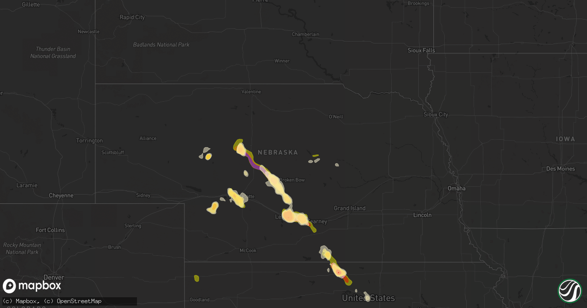
Hail Map in Nebraska on August 9, 2014
Get this storm
August 9 map
$229
one time, instant access
Download today. No call, no setup
Keep the $229
Bought the map and want the full workflow? Apply the entire $229 to a subscription within 7 days. None of it is wasted.
Every map, not just this one
This buys you this map. Subscription and you get every map we run, in the markets you choose from a few cities to whole states to nationwide. Plus real-time alerts the moment a storm fires.
Contact data
Name, contact info, occupancy, even credit band for addresses in the footprint. You go from where it hit to who to call.
Become the source they trust
Unlimited branding weather history reports on demand. You already have the documented answer ready for the property owner, and you are the one who showed up with it.
Property data and RoofTrace estimates
Pull up any address you have got, its value and the exact code rules for that jurisdiction, straight from One Click Code. Then RoofTrace estimates the squares, pitch, and roof value, priced the way you price.
Storm reports in Nebraska
Nebraska
| Date | Description |
|---|---|
| 08/09/20146:47 PM CDT | Very heavy rain at time of report along with the hail. |
| 08/09/20146:46 PM CDT | Delayed report of golf ball size hail during early stages of isolated severe storm on saturday evening. |
| 08/09/20146:45 PM CDT | Relayed via social media |
| 08/09/20146:33 PM CDT | Most hail stones were nickel to quarter size |
| 08/09/20146:15 PM CDT | Time estimated by radar |
| 08/09/20146:10 PM CDT | A local report indicates 1.25 inch wind near 1 N RINGGOLD |
| 08/09/20145:33 PM CDT | A local report indicates 1.75 inch wind near 17 S WHITMAN |
| 08/09/20144:27 PM CDT | Dime to quarter sized hail occurring. |
| 08/09/20144:22 PM CDT | Estimated wind gusts to 40 mph along with quarter sized hail and very heavy rain. |
| 08/09/20143:35 PM CDT | Baseball sized hail occurred again at 335 pm cdt. Very heavy rain still occurring. Ground completely white. |
| 08/09/20143:26 PM CDT | Golfball to baseball hail at time of report...along with very heavy rain. |
| 08/09/20149:12 AM CDT | A local report indicates 1.00 inch wind near 1 E BURWELL |
| 08/09/20149:12 AM CDT | A local report indicates 1.00 inch wind near 2 NW BURWELL |
| 08/08/201410:48 PM CDT | Officer est 60 mph wind gust in town |
| 08/08/201410:45 PM CDT | Delayed report of severe wind gust from saturday evening |
| 08/08/201410:35 PM CDT | Large tree limb broken at 7th and kansas |
| 08/08/201410:32 PM CDT | Via spotter network. |
| 08/08/201410:31 PM CDT | A local report indicates 71 MPH wind near HASTINGS AIRPORT |
| 08/08/201410:18 PM CDT | A local report indicates 60 MPH wind near 6 S WOOD RIVER |
| 08/08/201410:14 PM CDT | A local report indicates 72 MPH wind near 1 S WOOD RIVER |
| 08/08/20148:58 PM CDT | Pea to golf ball sized hail falling with 20 to 25 mph wind gusts. |
| 08/08/20148:56 PM CDT | Pea...marble...up to a few ping pong sized hail stones. Very heavy rain at time of report. |
| 08/08/20148:50 PM CDT | Quarter sized hail falling in elm creek with wind gusts of 30 to 40 mph. |
| 08/08/20148:34 PM CDT | Hail ranged from quarter to ping pong ball size |
| 08/08/20148:16 PM CDT | Golf ball to baseball sized hail ongoing. Estimated 55 mph wind gusts. |
| 08/08/20148:14 PM CDT | Pea size hail up to quarter and occasionally golf ball size hail. |
| 08/08/20148:12 PM CDT | A local report indicates 1.50 inch wind near 1 E LEXINGTON |
| 08/08/20148:10 PM CDT | Estimated 40 to 60 mph wind gusts...with dime sized hail. |
| 08/08/20148:04 PM CDT | A local report indicates 1.75 inch wind near 2 SSE HERSHEY |
| 08/08/20148:02 PM CDT | Officer reported pea to quarter sized hail |
| 08/08/20148:00 PM CDT | Very heavy rain occurring at time of report. |
| 08/08/20147:57 PM CDT | Along with ping ball sized hail...very heavy rain occurring. 2.03 inches rainfall so far at time of this report. |
| 08/08/20147:57 PM CDT | Quarter to half dollar sized hail along with very heavy rain. Visibility 1/4 mile or less. |
| 08/08/20147:46 PM CDT | Very heavy rain at time of report. |
| 08/08/20147:45 PM CDT | One inch hail occurred from 745-803 pm. Report from nerain observer. |
| 08/08/20147:25 PM CDT | A local report indicates 1.50 inch wind near CALLAWAY |
Cities Impacted by Hail Map on August 9, 2014
- Elm Creek, NE
- Riverton, NE
- Franklin, NE
- Elsie, NE
- Madrid, NE
- Paxton, NE
- North Platte, NE
- Hershey, NE
- Callaway, NE
- Arnold, NE
- Oconto, NE
- Smith Center, KS
- Lebanon, KS
- Sutherland, NE
- Eddyville, NE
- Lexington, NE
- Cozad, NE
- Maxwell, NE
- Whitman, NE
- Hildreth, NE
- Upland, NE
- Bloomington, NE
- Seneca, NE
- Overton, NE
- Kearney, NE
- Bertrand, NE
- Esbon, KS
- Billings, OK
- Thedford, NE
- Beloit, KS
- Simpson, KS
- Glasco, KS
- Anselmo, NE
- Merna, NE
- Red Rock, OK
- Pawnee, OK
- Marland, OK
- Hyannis, NE
- Elyria, NE
- Burwell, NE
- Defuniak Springs, FL
- Laurel Hill, FL
- Altha, FL
- Clarksville, FL
- Broken Bow, NE
- Stapleton, NE
- Greeley, NE
- Mankato, KS
- Westville, FL
- Barnard, KS
- Amherst, NE
- Sumner, NE
- Elwood, NE
- Inavale, NE
- Axtell, NE
- Odessa, NE
- Funk, NE
- Minden, NE
- Mullen, NE
- Saint Francis, KS


