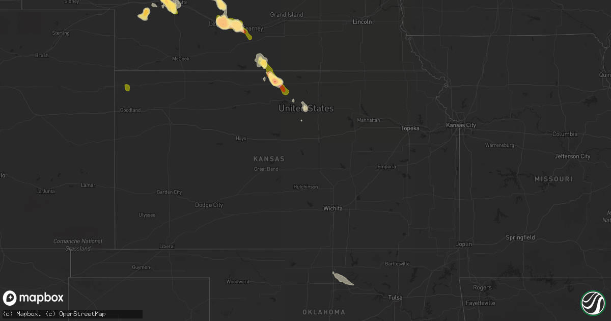
Hail Map in Kansas on August 9, 2014
Get this storm
August 9 map
$229
one time, instant access
Download today. No call, no setup
Keep the $229
Bought the map and want the full workflow? Apply the entire $229 to a subscription within 7 days. None of it is wasted.
Every map, not just this one
This buys you this map. Subscription and you get every map we run, in the markets you choose from a few cities to whole states to nationwide. Plus real-time alerts the moment a storm fires.
Contact data
Name, contact info, occupancy, even credit band for addresses in the footprint. You go from where it hit to who to call.
Become the source they trust
Unlimited branding weather history reports on demand. You already have the documented answer ready for the property owner, and you are the one who showed up with it.
Property data and RoofTrace estimates
Pull up any address you have got, its value and the exact code rules for that jurisdiction, straight from One Click Code. Then RoofTrace estimates the squares, pitch, and roof value, priced the way you price.
Storm reports in Kansas
Kansas
| Date | Description |
|---|---|
| 08/09/20146:13 PM CDT | Pea-sized hail as well |
| 08/09/20145:22 PM CDT | A local report indicates 60 MPH wind near 2 N SHARON SPRINGS |
| 08/09/20144:55 PM CDT | A local report indicates a tornado near 10 SSW BIRD CITY |
| 08/09/20144:50 PM CDT | A local report indicates 60 MPH wind near 5 N WESKAN |
| 08/09/20143:57 PM CDT | Emergency manager report of touchdown near the intersection of road i/20. |
| 08/09/20143:57 PM CDT | Half mile south of st francis |
| 08/09/20143:45 PM CDT | Landspout |
| 08/08/201411:00 PM CDT | A semi-trailer was blown over on highway 400... 2 miles west of dodge city. |
| 08/08/201410:44 PM CDT | A local report indicates 60 MPH wind near 3 ENE DODGE CITY |
| 08/08/20149:46 PM CDT | This is a kdot report. |
| 08/08/20149:44 PM CDT | Est 50 to 60 mph winds with nickle sized hail |
| 08/08/20149:40 PM CDT | Radar est time |
| 08/08/20149:35 PM CDT | A local report indicates 1.25 inch wind near 6 E BELOIT |
| 08/08/20148:50 PM CDT | Estimated 60 mph wind gusts peaking about 850 pm. 4 inch diameter branches down in town. Estimated dime sized hail and very heavy rain. |
| 08/08/20148:47 PM CDT | A local report indicates 2.75 inch wind near 2 S LEBANON |
| 08/08/20148:47 PM CDT | 14 power poles down and many tree limbs down |
| 08/08/20148:30 PM CDT | Half dollar sized hail ongoing for 10 minutes. Spotter located ne side of town. |
| 08/08/20148:27 PM CDT | A local report indicates 1.75 inch wind near LEBANON |
| 08/08/20148:24 PM CDT | Estimated 70-80 mph winds and golf ball sized hail. |
| 08/08/20148:23 PM CDT | A local report indicates 59 MPH wind near SMITH CENTER AIRPORT |
| 08/08/20148:22 PM CDT | Hail has been ongoing for over 10 minutes and just increased to golf ball sized. |
| 08/08/20148:16 PM CDT | A local report indicates 58 MPH wind near SMITH CENTER AIRPORT |
| 08/08/20148:14 PM CDT | A local report indicates 1.00 inch wind near 5 N BELLAIRE |
| 08/08/20148:12 PM CDT | Officer reported a wind gust of 60 mph north of bellaire |
| 08/08/20148:05 PM CDT | A local report indicates 60 MPH wind near 9 NE KENDALL |
| 08/08/20147:48 PM CDT | Report from the syracuse awos. |
| 08/08/20147:10 PM CDT | Most of the hail has been pea size or a little larger. |
Cities Impacted by Hail Map on August 9, 2014
- Elm Creek, NE
- Riverton, NE
- Franklin, NE
- Elsie, NE
- Madrid, NE
- Paxton, NE
- North Platte, NE
- Hershey, NE
- Callaway, NE
- Arnold, NE
- Oconto, NE
- Smith Center, KS
- Lebanon, KS
- Sutherland, NE
- Eddyville, NE
- Lexington, NE
- Cozad, NE
- Maxwell, NE
- Whitman, NE
- Hildreth, NE
- Upland, NE
- Bloomington, NE
- Seneca, NE
- Overton, NE
- Kearney, NE
- Bertrand, NE
- Esbon, KS
- Billings, OK
- Thedford, NE
- Beloit, KS
- Simpson, KS
- Glasco, KS
- Anselmo, NE
- Merna, NE
- Red Rock, OK
- Pawnee, OK
- Marland, OK
- Hyannis, NE
- Elyria, NE
- Burwell, NE
- Defuniak Springs, FL
- Laurel Hill, FL
- Altha, FL
- Clarksville, FL
- Broken Bow, NE
- Stapleton, NE
- Greeley, NE
- Mankato, KS
- Westville, FL
- Barnard, KS
- Amherst, NE
- Sumner, NE
- Elwood, NE
- Inavale, NE
- Axtell, NE
- Odessa, NE
- Funk, NE
- Minden, NE
- Mullen, NE
- Saint Francis, KS


