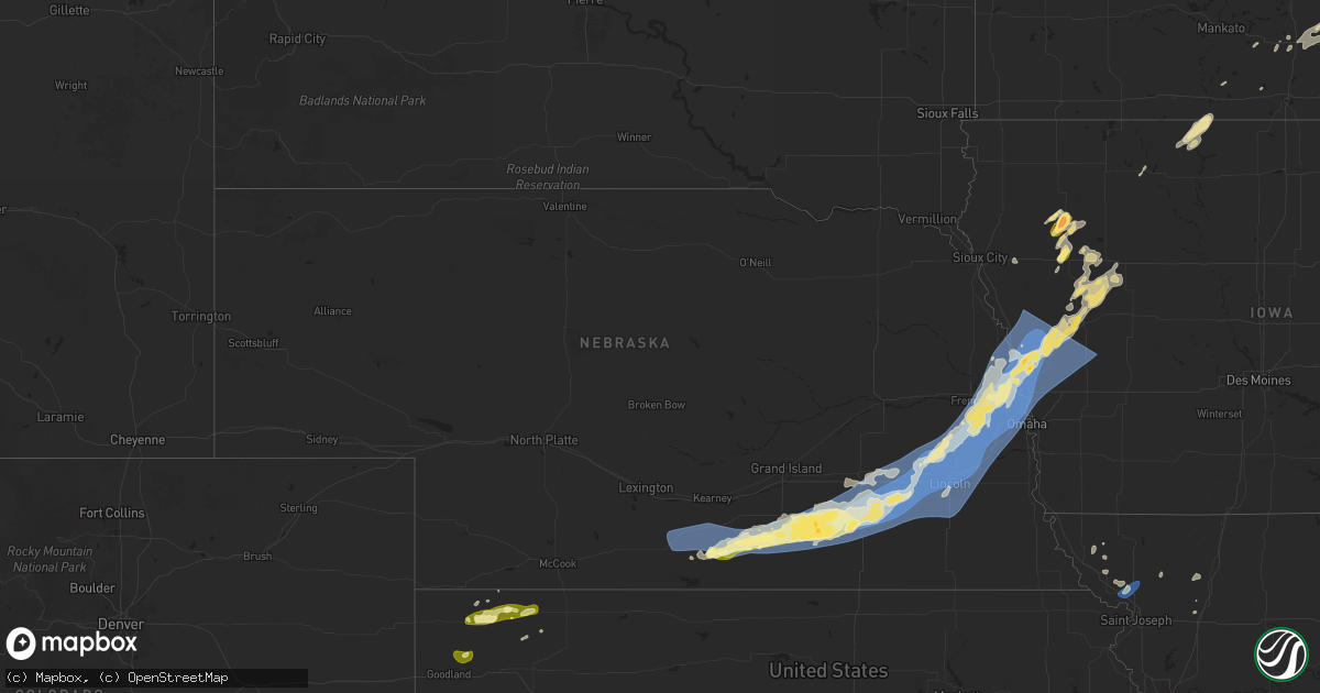
Hail Map in Nebraska on August 8, 2025
Get this storm
August 8 map
$229
one time, instant access
Download today. No call, no setup
Keep the $229
Bought the map and want the full workflow? Apply the entire $229 to a subscription within 7 days. None of it is wasted.
Every map, not just this one
This buys you this map. Subscription and you get every map we run, in the markets you choose from a few cities to whole states to nationwide. Plus real-time alerts the moment a storm fires.
Contact data
Name, contact info, occupancy, even credit band for addresses in the footprint. You go from where it hit to who to call.
Become the source they trust
Unlimited branding weather history reports on demand. You already have the documented answer ready for the property owner, and you are the one who showed up with it.
Property data and RoofTrace estimates
Pull up any address you have got, its value and the exact code rules for that jurisdiction, straight from One Click Code. Then RoofTrace estimates the squares, pitch, and roof value, priced the way you price.
Storm reports in Nebraska
Nebraska
| Date | Description |
|---|---|
| 08/08/20256:35 AM CDT | Asos station ktqe tekamah airport. |
| 08/08/20256:35 AM CDT | Asos station ktqe |
| 08/08/20256:28 AM CDT | Measured by a |
| 08/08/20256:28 AM CDT | Measured by a public weather station. |
| 08/08/20256:26 AM CDT | Building roof collapse. Time estimated based on radar data. |
| 08/08/20256:24 AM CDT | Measured by a public weather station. |
| 08/08/20256:24 AM CDT | Measured by a public weather station |
| 08/08/20256:22 AM CDT | Measured by a personal weather station. |
| 08/08/20256:22 AM CDT | Delayed report from social media of a large tree trunk snapped |
| 08/08/20256:20 AM CDT | Measured by a public weather station near 156th and state st. |
| 08/08/20256:20 AM CDT | Measured by a personal weather station. |
| 08/08/20256:16 AM CDT | Measured by a public weather station near 168th and bennington rd. Multiple other stations in close proximity measured gusts in the 60s. |
| 08/08/20256:15 AM CDT | First observation with severe wind at awos station kbta blair muni. |
| 08/08/20256:14 AM CDT | Measured by a public weather station. |
| 08/08/20256:11 AM CDT | Measured by a personal weather station near 114th and state. |
| 08/08/20256:10 AM CDT | Delayed report via social media of siding ripped off a garage and large trees |
| 08/08/20256:08 AM CDT | Measured by public weather station just east of the north omaha airport. |
| 08/08/20256:06 AM CDT | Measured by public weather station. |
| 08/08/20256:05 AM CDT | Delayed report of roof damage with insulation blow over the road and an overturned semi-truck. Time estimated from radar. |
| 08/08/20256:05 AM CDT | Shed destroyed. |
| 08/08/20256:04 AM CDT | Multiple tree limbs down |
| 08/08/20256:04 AM CDT | Retired meteorologist reports peak gust of 83 mph on home weather station. |
| 08/08/20256:04 AM CDT | Power outages reported in boys town. |
| 08/08/20256:03 AM CDT | Delayed report of snapped power poles. Time estimated from radar. |
| 08/08/20256:03 AM CDT | A local report indicates 77 MPH wind near 1 WNW Valley |
| 08/08/20256:02 AM CDT | Report relayed via social media of a large tree down on a truck and minivan. Time estimated from radar. |
| 08/08/20256:01 AM CDT | Measured by public weather station. |
| 08/08/20256:00 AM CDT | Measured by public weather station near 168th and fort st. |
| 08/08/20256:00 AM CDT | Power outages reported by off duty nws employee. |
| 08/08/20256:00 AM CDT | Delayed report of trees snapped |
| 08/08/20255:59 AM CDT | Measured by a public weather station near 132nd and west maple. |
| 08/08/20255:58 AM CDT | Boat canopy destroyed. Report time based on radar. |
| 08/08/20255:58 AM CDT | Large tree branches snapped off. Report with photos received via social media. Report time based on radar. |
| 08/08/20255:57 AM CDT | Measured by public weather station near 192nd and harrison. |
| 08/08/20255:56 AM CDT | Personal weather station measured gust. |
| 08/08/20255:55 AM CDT | Delayed report via social media of several tree branches down |
| 08/08/20255:55 AM CDT | Awos station kmle millard airport. |
| 08/08/20255:54 AM CDT | Off duty nws employee. Possibly higher. |
| 08/08/20255:54 AM CDT | A local report indicates 80 MPH wind near 4 N Gretna |
| 08/08/20255:52 AM CDT | Powerlines down with considerable tree damage near the intersection of highway 36 and 204th street. Report time based on radar. |
| 08/08/20255:52 AM CDT | Measured by public weather station. |
| 08/08/20255:50 AM CDT | Porch roof torn off. |
| 08/08/20255:50 AM CDT | Measured by public weather station. |
| 08/08/20255:50 AM CDT | Delayed report via social media of broken windows in a home and lots of tree damage with large limbs |
| 08/08/20255:49 AM CDT | Report time based on radar. |
| 08/08/20255:49 AM CDT | Measured by public weather station. Near 204th and q st. |
| 08/08/20255:48 AM CDT | Delayed report via social media of power lines leaning into the road. Time estimated from radar. |
| 08/08/20255:47 AM CDT | Widespread tree and powerline damage. Report received via social media. Report time based on radar. |
| 08/08/20255:47 AM CDT | Delayed report via social media of extensive tree damage with several large branches |
| 08/08/20255:45 AM CDT | Measured by public weather station. |
| 08/08/20255:44 AM CDT | Measured by public weather station. |
| 08/08/20255:41 AM CDT | Measured by public weather station. |
| 08/08/20255:40 AM CDT | Barn destroyed. |
| 08/08/20255:37 AM CDT | Large tree uprooted and roof damage to a shed. |
| 08/08/20255:35 AM CDT | Measured by public weather station. |
| 08/08/20255:29 AM CDT | Measured by public weather station. |
| 08/08/20255:28 AM CDT | Delayed report. Time estimated with radar. |
| 08/08/20255:28 AM CDT | Measured by public weather station. |
| 08/08/20255:23 AM CDT | Measured by public weather station. |
| 08/08/20255:23 AM CDT | A local report indicates 60 MPH wind near Greenwood |
| 08/08/20255:22 AM CDT | Measured by public weather station. Appears justified based on upstream reports near lincoln. |
| 08/08/20255:22 AM CDT | Asos station klnk lincoln airport. |
| 08/08/20255:21 AM CDT | Measured by public weather station near 27th and pine lake road. |
| 08/08/20255:20 AM CDT | Measured by public weather station. |
| 08/08/20255:20 AM CDT | Measured by public weather station. |
| 08/08/20255:19 AM CDT | Measured by public weather station. |
| 08/08/20255:16 AM CDT | Measured by public weather station. |
| 08/08/20255:15 AM CDT | Measured by public weather station. |
| 08/08/20255:12 AM CDT | Asos station klnk lincoln airport. |
| 08/08/20255:08 AM CDT | Asos station klnk lincoln airport. |
| 08/08/20255:07 AM CDT | Trained spotter reported wind gusts estimated up to 80 mph and extensive tree damage. Time estimated from radar. |
| 08/08/20255:04 AM CDT | Large tree snapped off at the ground. Report with photo received via social media. Report time based on radar. |
| 08/08/20255:01 AM CDT | Measured by public weather station. |
| 08/08/20255:01 AM CDT | Large tree snapped off near the ground. Report with photo received via social media. Report time based on radar. |
| 08/08/20255:00 AM CDT | Overturned camper. Report received with photo via social media. Report time based on radar. |
| 08/08/20254:58 AM CDT | Snapped telephone poles holding the football field lights. |
| 08/08/20254:57 AM CDT | Measured by public weather station. |
| 08/08/20254:56 AM CDT | Measured by public weather station. |
| 08/08/20254:56 AM CDT | Measured by public weather station. |
| 08/08/20254:55 AM CDT | Report relayed via social media images of large trees down... One impacting a roof. Time estimated from radar. |
| 08/08/20254:55 AM CDT | Delayed report of large trees down and a roof torn off a shed. Time estimated from radar. |
| 08/08/20254:54 AM CDT | Measured by public weather station. |
| 08/08/20254:54 AM CDT | Asos station klnk lincoln airport. |
| 08/08/20254:53 AM CDT | Measured by public weather station. |
| 08/08/20254:53 AM CDT | Power outages in town. |
| 08/08/20254:50 AM CDT | Delayed report from social media of a large tree |
| 08/08/20254:50 AM CDT | Measured by public weather station. |
| 08/08/20254:50 AM CDT | Measured by public weather station. |
| 08/08/20254:46 AM CDT | Large tree branches down. Report with photo received via social media. Report time based on radar. |
| 08/08/20254:45 AM CDT | Measured by public weather station. |
| 08/08/20254:40 AM CDT | Large tree down around the intersection of 8th or 9th street and grove ave. Time estimated from radar. |
| 08/08/20254:37 AM CDT | Large tree down on house and vehicle. Report with photo received via social media. Report time based on radar. |
| 08/08/20254:35 AM CDT | Measured by public weather station. |
| 08/08/20254:34 AM CDT | Large tree branch on a house. Report with photo received via social media. Report time based on radar. |
| 08/08/20254:32 AM CDT | Measured by public weather station. |
| 08/08/20254:32 AM CDT | Davis weather station. |
| 08/08/20254:30 AM CDT | Davis weather station. |
| 08/08/20254:26 AM CDT | Davis weather station. |
| 08/08/20254:25 AM CDT | Gust measured from a public weather station. |
| 08/08/20254:25 AM CDT | Delayed emergency manager report of measured wind gusts up to 84 mph. Time estimated from radar. |
| 08/08/20254:25 AM CDT | Power outages reported in exeter area. |
| 08/08/20254:25 AM CDT | Emergency manager reports trees down... Power outages in friend... With an estimated 80-90 mph wind speed. |
| 08/08/20254:14 AM CDT | Via personal weather station. Gust measured on the leading edge of the storm. |
| 08/08/20254:12 AM CDT | Via davis weatherlink personal weather station. Observation is appears to be supported by area damage reports and by radar. |
| 08/08/20254:11 AM CDT | Power outages in fairmont. |
| 08/08/20254:11 AM CDT | Davis weather station. |
| 08/08/20254:09 AM CDT | Photo on social media from sheriffs department showing a powerline down over highway 6 west of fairmont. Time estimated from radar. |
| 08/08/20254:09 AM CDT | Photo on social media from sheriffs dept showing a damaged grain bin and an overturned semi. Time estimated from radar. |
| 08/08/20254:08 AM CDT | Reports of large tree limbs down and power out in grafton. |
| 08/08/20254:05 AM CDT | Via personal weather station. |
| 08/08/20254:05 AM CDT | Davis weather station. |
| 08/08/20254:04 AM CDT | Power out in shickley area per em. |
| 08/08/20253:58 AM CDT | Via personal weather station. |
| 08/08/20253:53 AM CDT | Davis weather station. |
| 08/08/20253:52 AM CDT | Ambient weather station. |
| 08/08/20253:49 AM CDT | Started as pea size... Then dime size before some quarter size hail fell. Some crop damage in general area. |
| 08/08/20253:49 AM CDT | Via personal weather station. |
| 08/08/20253:49 AM CDT | A local report indicates 1.00 inch wind near 6 E Clay Center |
| 08/08/20253:49 AM CDT | Via personal weather station. |
| 08/08/20253:46 AM CDT | 50 to 60 mph winds and dime size hail... Very heavy rain. |
| 08/08/20253:42 AM CDT | A local report indicates 60 MPH wind near 6 E Clay Center |
| 08/08/20253:38 AM CDT | Davis weather station. |
| 08/08/20253:37 AM CDT | A local report indicates 60 MPH wind near Clay Center |
| 08/08/20253:36 AM CDT | Via personal weather station. |
| 08/08/20253:34 AM CDT | A local report indicates 60 MPH wind near Edgar |
| 08/08/20253:34 AM CDT | A local report indicates 1.00 inch wind near Fairfield |
| 08/08/20253:28 AM CDT | Mesonet station up021 fairfield 2.1w |
| 08/08/20253:25 AM CDT | Multiple reports of 50-60 mph wind gusts and pea size hail from glenvil area spotters. |
| 08/08/20253:25 AM CDT | Multiple reports of 50-60 mph wind gusts and pea size hail from glenvil area spotters. |
| 08/08/20253:25 AM CDT | Multiple reports of 50-60 mph wind gusts and pea size hail from fairfield area spotters. |
| 08/08/20253:00 AM CDT | Photo on social media of a collapsed grain bin in blue hill. Time estimated from radar. |
| 08/08/20252:53 AM CDT | Wind gusts at least 50-60 mph. Also have pea size hail. |
| 08/08/20252:46 AM CDT | Via personal weather station. |
| 08/08/20252:15 AM CDT | Via personal weather station. |
| 08/08/20251:55 AM CDT | Awos station khde holdrege airport. |
| 08/08/20251:47 AM CDT | Gust reported on awos voice line. Time estimated from radar. |
All States Impacted by Hail Map on August 8, 2025
Cities Impacted by Hail Map on August 8, 2025
- Bird City, KS
- McDonald, KS
- Atwood, KS
- Ludell, KS
- Northwood, ND
- Presque Isle, MI
- Browerville, MN
- Staples, MN
- Motley, MN
- Little Falls, MN
- Pillager, MN
- Rice, MN
- Pierz, MN
- Royalton, MN
- Brainerd, MN
- Hillman, MN
- Deerwood, MN
- Crosby, MN
- Ironton, MN
- Aitkin, MN
- Mcgregor, MN
- Cushing, MN
- Palisade, MN
- Tamarack, MN
- Kettle River, MN
- Cromwell, MN
- Wright, MN
- Floodwood, MN
- Jacobson, MN
- Brookston, MN
- Sturgeon Lake, MN
- Alborn, MN
- Meadowlands, MN
- Kerrick, MN
- Holyoke, MN
- Cotton, MN
- Makinen, MN
- Eveleth, MN
- Aurora, MN
- Gilbert, MN
- Hoyt Lakes, MN
- Brimson, MN
- Babbitt, MN
- Anahuac, TX
- Port Arthur, TX
- Hickory Valley, TN
- Mio, MI
- Grand Junction, TN
- Winnie, TX
- Somerville, TN
- Posen, MI
- La Grange, TN
- Moscow, TN
- Hillman, MI
- Ripley, TN
- Lachine, MI
- Orange, TX
- Memphis, TN
- Brockton, MT
- Vinton, LA
- Plentywood, MT
- Westby, MT
- Antelope, MT
- Reserve, MT
- Dalhart, TX
- Vidor, TX
- Rose City, MI
- Buna, TX
- Millington, TN
- Lupton, MI
- Fortuna, ND
- Kirbyville, TX
- Bayfield, WI
- Quinter, KS
- Silsbee, TX
- Collyer, KS
- Livingston, TX
- Wakeeney, KS
- South Branch, MI
- Ellis, KS
- Ogallah, KS
- West Branch, MI
- Ironwood, MI
- Houston, TX
- Bellaire, TX
- Bessemer, MI
- Wakefield, MI
- Ontonagon, MI
- Marenisco, MI
- Bergland, MI
- Ewen, MI
- Prescott, MI
- Alger, MI
- Fairview, MI
- Iron River, MI
- Crystal Falls, MI
- Villard, MN
- Glenwood, MN
- Osakis, MN
- Trout Creek, MI
- Long Prairie, MN
- Goodland, KS
- Sauk Centre, MN
- Edson, KS
- Belgrade, MN
- Paynesville, MN
- New London, MN
- Rosholt, WI
- Mosinee, WI
- Amasa, MI
- Hatley, WI
- Channing, MI
- Republic, MI
- Eden Valley, MN
- Grove City, MN
- Kimball, MN
- Watkins, MN
- Litchfield, MN
- Sagola, MI
- Iron Mountain, MI
- Foster City, MI
- Cosmos, MN
- Felch, MI
- South Haven, MN
- Darwin, MN
- Vulcan, MI
- Clearwater, MN
- Annandale, MN
- Dassel, MN
- Pequot Lakes, MN
- Hutchinson, MN
- Nisswa, MN
- Cokato, MN
- Norway, MI
- Howard Lake, MN
- Remer, MN
- Clear Lake, MN
- Monticello, MN
- Becker, MN
- Holdrege, NE
- Atlanta, NE
- Orleans, NE
- Wilcox, NE
- Hildreth, NE
- Alma, NE
- Axtell, NE
- Loomis, NE
- Funk, NE
- Naponee, NE
- Bloomington, NE
- Minden, NE
- Cherokee, IA
- Quimby, IA
- Waverly, MN
- Buffalo, MN
- Carney, MI
- Maple Lake, MN
- Republican City, NE
- Upland, NE
- Franklin, NE
- Elk River, MN
- Cohasset, MN
- Big Lake, MN
- Hermansville, MI
- Perronville, MI
- Deer River, MN
- Campbell, NE
- Holstein, NE
- Bladen, NE
- Winsted, MN
- Silver Lake, MN
- Roseland, NE
- Montrose, MN
- Aurelia, IA
- Glencoe, MN
- Lester Prairie, MN
- Blue Hill, NE
- Ayr, NE
- Glenvil, NE
- Hastings, NE
- Bethel, MN
- Cedar, MN
- Cleghorn, IA
- Wyoming, MN
- Alta, IA
- Hibbing, MN
- Plato, MN
- Mayer, MN
- Delano, MN
- Watertown, MN
- Fairfax, MO
- Orr, MN
- Stacy, MN
- North Branch, MN
- Fairfield, NE
- Lawrence, NE
- New Germany, MN
- Young America, MN
- Maple Plain, MN
- Rockford, MN
- Lindstrom, MN
- Chisago City, MN
- Cook, MN
- Saint Francis, KS
- Edgar, NE
- Clay Center, NE
- Arlington, MN
- Green Isle, MN
- Deweese, NE
- Cologne, MN
- Norwood Young America, MN
- Waconia, MN
- Harris, MN
- Harvard, NE
- Inland, NE
- Minneapolis, MN
- Andover, MN
- Ong, NE
- Saronville, NE
- Sutton, NE
- Long Lake, MN
- Loretto, MN
- Saint Croix Falls, WI
- Biwabik, MN
- Embarrass, MN
- Center City, MN
- Taylors Falls, MN
- Hamel, MN
- Mound, MN
- Meriden, IA
- Davenport, NE
- Strang, NE
- Nelson, NE
- Shickley, NE
- Geneva, NE
- Grafton, NE
- Holstein, IA
- Cushing, IA
- Skidmore, MO
- Ely, MN
- Maitland, MO
- Mound City, MO
- Osceola, WI
- Scandia, MN
- Cushing, WI
- Battle Creek, IA
- Hopkins, MN
- Wayzata, MN
- Osseo, MN
- Maple Grove, MN
- Minnetonka, MN
- Milligan, NE
- Friend, NE
- Exeter, NE
- Fairmont, NE
- Ohiowa, NE
- Tobias, NE
- McCool Junction, NE
- Beaver Crossing, NE
- Henderson, NE
- Cordova, NE
- York, NE
- Belle Plaine, MN
- Henderson, MN
- Moville, IA
- Lawton, IA
- Clear Lake, WI
- Clayton, WI
- Eden Prairie, MN
- Aurora, NE
- Oregon, MO
- Dresser, WI
- Turtle Lake, WI
- Washta, IA
- Lake Elmo, MN
- Saint Paul, MN
- Moose Lake, MN
- Dorchester, NE
- Cumberland, WI
- Comstock, WI
- Fillmore, MO
- Crete, NE
- Western, NE
- Pleasant Dale, NE
- Denton, NE
- Milford, NE
- Waco, NE
- Seward, NE
- Utica, NE
- Garland, NE
- Bee, NE
- Lincoln, NE
- Staplehurst, NE
- Goehner, NE
- Martell, NE
- Hallam, NE
- Tower, MN
- Galva, IA
- Schaller, IA
- Shell Lake, WI
- Almena, WI
- Barron, WI
- Savannah, MO
- Raymond, NE
- Valparaiso, NE
- Hertel, WI
- Sprague, NE
- Hickman, NE
- Bennet, NE
- Roca, NE
- Walton, NE
- Malcolm, NE
- Dwight, NE
- Davey, NE
- Firth, NE
- Ceresco, NE
- Spooner, WI
- Rice Lake, WI
- Oberlin, KS
- Forbes, MN
- Ida Grove, IA
- Arthur, IA
- Herndon, KS
- Peterson, MN
- Lewiston, MN
- Weston, NE
- Springbrook, WI
- Trego, WI
- Alma, WI
- Sarona, WI
- Yutan, NE
- Winona, MN
- Houston, MN
- Mead, NE
- Ithaca, NE
- Wahoo, NE
- Guilford, MO
- King City, MO
- Delavan, MN
- Rushford, MN
- Eagle, NE
- Greenwood, NE
- Alvo, NE
- Waverly, NE
- Ashland, NE
- Kennard, NE
- Blair, NE
- Fremont, NE
- Valley, NE
- Waterloo, NE
- Rollingstone, MN
- Stone Lake, WI
- Kiron, IA
- Odebolt, IA
- Early, IA
- Schleswig, IA
- Bennington, NE
- Washington, NE
- Elk Mound, WI
- Colfax, WI
- Menomonie, WI
- Arlington, NE
- Cochrane, WI
- Memphis, NE
- Gretna, NE
- Colon, NE
- Elkhorn, NE
- Springfield, NE
- La Vista, NE
- Papillion, NE
- Omaha, NE
- South Bend, NE
- Murdock, NE
- Hayward, WI
- Woodbine, IA
- Dunlap, IA
- Bloomer, WI
- Mondovi, WI
- Chippewa Falls, WI
- Missouri Valley, IA
- Modale, IA
- Couderay, WI
- Janesville, MN
- Pemberton, MN
- Logan, IA
- Nickerson, NE
- Boys Town, NE
- Herman, NE
- Fort Calhoun, NE
- Magnolia, IA
- Mondamin, IA
- Arion, IA
- Dow City, IA
- Waseca, MN
- McFall, MO
- Eleva, WI
- Independence, WI
- Owatonna, MN
- Lake View, IA
- Ruthven, IA
- Emmetsburg, IA
- Isabella, MN
- Pisgah, IA
- Crescent, IA
- Neola, IA
- Honey Creek, IA
- Tekamah, NE
- Deloit, IA
- Strum, WI
- Pattonsburg, MO
- West Concord, MN
- Kenyon, MN
- Osseo, WI
- Denison, IA
- Armstrong, IA
- Swea City, IA
- Bancroft, IA
- Fenton, IA
- Sac City, IA
- Wall Lake, IA
- Ringsted, IA
- Moorhead, IA
- Blencoe, IA
- Little Sioux, IA
- Craig, NE
- Portsmouth, IA
- Persia, IA
- Onawa, IA
- Harlan, IA
- Panama, IA
- Earling, IA
- Dennison, MN
- Cannon Falls, MN
- Ledyard, IA
- Augusta, WI
- Finland, MN
- Alden, MN
- Fairchild, WI
- Charter Oak, IA
- Ute, IA
- Castana, IA
- Soldier, IA
- Westphalia, IA
- Defiance, IA
- Kirkman, IA
- Irwin, IA
- Willard, WI
- Thorp, WI
- Boyd, WI
- Weatherby, MO
- Elmore, MN
- Cameron, MO
- Claremont, MN
- Dodge Center, MN
- Fountain City, WI
- Pine Island, MN
- Stockholm, WI
- Vail, IA
- Lone Rock, IA
- Blue Earth, MN
- Stanley, WI
- Withee, WI
- Marcus, IA
- Malmo, NE
- Rosendale, MO
- Amazonia, MO


