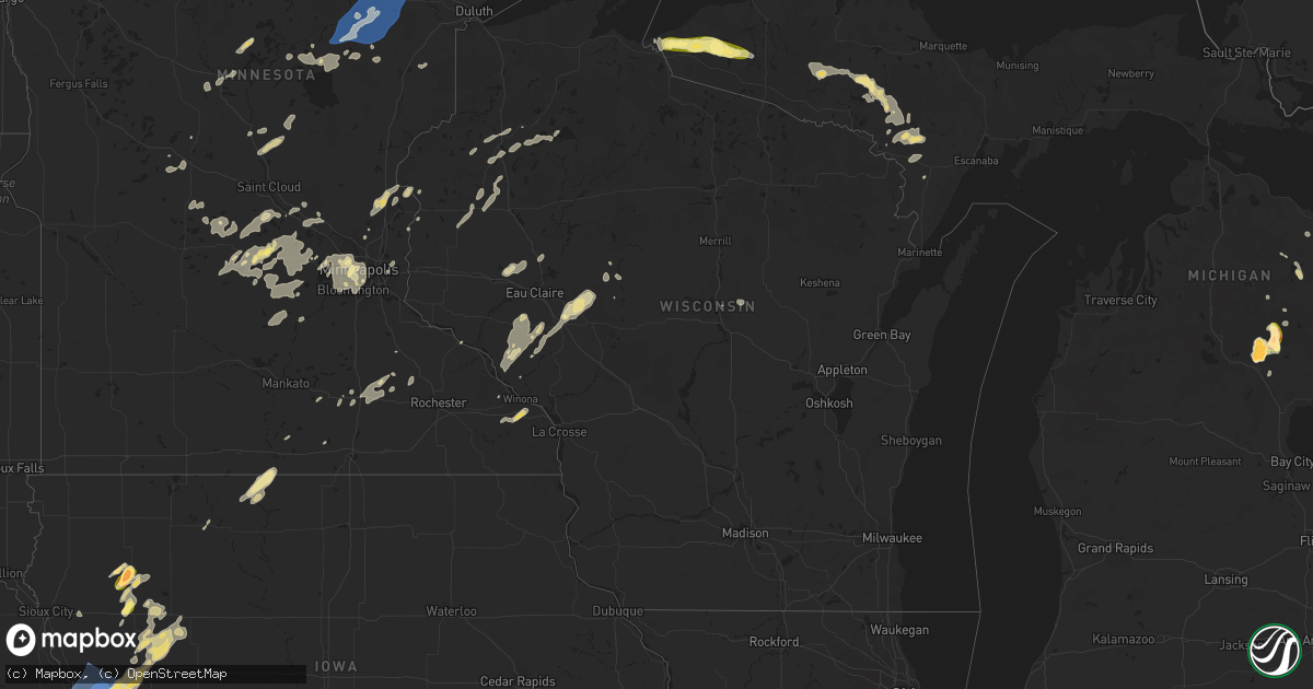
Hail Map in Wisconsin on August 8, 2025
Get this storm
August 8 map
$229
one time, instant access
Download today. No call, no setup
Keep the $229
Bought the map and want the full workflow? Apply the entire $229 to a subscription within 7 days. None of it is wasted.
Every map, not just this one
This buys you this map. Subscription and you get every map we run, in the markets you choose from a few cities to whole states to nationwide. Plus real-time alerts the moment a storm fires.
Contact data
Name, contact info, occupancy, even credit band for addresses in the footprint. You go from where it hit to who to call.
Become the source they trust
Unlimited branding weather history reports on demand. You already have the documented answer ready for the property owner, and you are the one who showed up with it.
Property data and RoofTrace estimates
Pull up any address you have got, its value and the exact code rules for that jurisdiction, straight from One Click Code. Then RoofTrace estimates the squares, pitch, and roof value, priced the way you price.
Storm reports in Wisconsin
Wisconsin
| Date | Description |
|---|---|
| 08/08/20255:50 AM CDT | Multiple trees down completely blocking peninsula and linden road 6 miles east of hayward wisconsin. Roads are completely impassible. Time estimated by radar. |
| 08/08/20255:45 AM CDT | 2 aspen trees 10 inch in diameter uprooted. |
| 08/08/20254:40 AM CDT | Photos were received via social media showing trees down with one uprooted and down over the road near the southeast end of the shell lake airport. Time estimated by ra |
All States Impacted by Hail Map on August 8, 2025
Cities Impacted by Hail Map on August 8, 2025
- Bird City, KS
- McDonald, KS
- Atwood, KS
- Ludell, KS
- Northwood, ND
- Presque Isle, MI
- Browerville, MN
- Staples, MN
- Motley, MN
- Little Falls, MN
- Pillager, MN
- Rice, MN
- Pierz, MN
- Royalton, MN
- Brainerd, MN
- Hillman, MN
- Deerwood, MN
- Crosby, MN
- Ironton, MN
- Aitkin, MN
- Mcgregor, MN
- Cushing, MN
- Palisade, MN
- Tamarack, MN
- Kettle River, MN
- Cromwell, MN
- Wright, MN
- Floodwood, MN
- Jacobson, MN
- Brookston, MN
- Sturgeon Lake, MN
- Alborn, MN
- Meadowlands, MN
- Kerrick, MN
- Holyoke, MN
- Cotton, MN
- Makinen, MN
- Eveleth, MN
- Aurora, MN
- Gilbert, MN
- Hoyt Lakes, MN
- Brimson, MN
- Babbitt, MN
- Anahuac, TX
- Port Arthur, TX
- Hickory Valley, TN
- Mio, MI
- Grand Junction, TN
- Winnie, TX
- Somerville, TN
- Posen, MI
- La Grange, TN
- Moscow, TN
- Hillman, MI
- Ripley, TN
- Lachine, MI
- Orange, TX
- Memphis, TN
- Brockton, MT
- Vinton, LA
- Plentywood, MT
- Westby, MT
- Antelope, MT
- Reserve, MT
- Dalhart, TX
- Vidor, TX
- Rose City, MI
- Buna, TX
- Millington, TN
- Lupton, MI
- Fortuna, ND
- Kirbyville, TX
- Bayfield, WI
- Quinter, KS
- Silsbee, TX
- Collyer, KS
- Livingston, TX
- Wakeeney, KS
- South Branch, MI
- Ellis, KS
- Ogallah, KS
- West Branch, MI
- Ironwood, MI
- Houston, TX
- Bellaire, TX
- Bessemer, MI
- Wakefield, MI
- Ontonagon, MI
- Marenisco, MI
- Bergland, MI
- Ewen, MI
- Prescott, MI
- Alger, MI
- Fairview, MI
- Iron River, MI
- Crystal Falls, MI
- Villard, MN
- Glenwood, MN
- Osakis, MN
- Trout Creek, MI
- Long Prairie, MN
- Goodland, KS
- Sauk Centre, MN
- Edson, KS
- Belgrade, MN
- Paynesville, MN
- New London, MN
- Rosholt, WI
- Mosinee, WI
- Amasa, MI
- Hatley, WI
- Channing, MI
- Republic, MI
- Eden Valley, MN
- Grove City, MN
- Kimball, MN
- Watkins, MN
- Litchfield, MN
- Sagola, MI
- Iron Mountain, MI
- Foster City, MI
- Cosmos, MN
- Felch, MI
- South Haven, MN
- Darwin, MN
- Vulcan, MI
- Clearwater, MN
- Annandale, MN
- Dassel, MN
- Pequot Lakes, MN
- Hutchinson, MN
- Nisswa, MN
- Cokato, MN
- Norway, MI
- Howard Lake, MN
- Remer, MN
- Clear Lake, MN
- Monticello, MN
- Becker, MN
- Holdrege, NE
- Atlanta, NE
- Orleans, NE
- Wilcox, NE
- Hildreth, NE
- Alma, NE
- Axtell, NE
- Loomis, NE
- Funk, NE
- Naponee, NE
- Bloomington, NE
- Minden, NE
- Cherokee, IA
- Quimby, IA
- Waverly, MN
- Buffalo, MN
- Carney, MI
- Maple Lake, MN
- Republican City, NE
- Upland, NE
- Franklin, NE
- Elk River, MN
- Cohasset, MN
- Big Lake, MN
- Hermansville, MI
- Perronville, MI
- Deer River, MN
- Campbell, NE
- Holstein, NE
- Bladen, NE
- Winsted, MN
- Silver Lake, MN
- Roseland, NE
- Montrose, MN
- Aurelia, IA
- Glencoe, MN
- Lester Prairie, MN
- Blue Hill, NE
- Ayr, NE
- Glenvil, NE
- Hastings, NE
- Bethel, MN
- Cedar, MN
- Cleghorn, IA
- Wyoming, MN
- Alta, IA
- Hibbing, MN
- Plato, MN
- Mayer, MN
- Delano, MN
- Watertown, MN
- Fairfax, MO
- Orr, MN
- Stacy, MN
- North Branch, MN
- Fairfield, NE
- Lawrence, NE
- New Germany, MN
- Young America, MN
- Maple Plain, MN
- Rockford, MN
- Lindstrom, MN
- Chisago City, MN
- Cook, MN
- Saint Francis, KS
- Edgar, NE
- Clay Center, NE
- Arlington, MN
- Green Isle, MN
- Deweese, NE
- Cologne, MN
- Norwood Young America, MN
- Waconia, MN
- Harris, MN
- Harvard, NE
- Inland, NE
- Minneapolis, MN
- Andover, MN
- Ong, NE
- Saronville, NE
- Sutton, NE
- Long Lake, MN
- Loretto, MN
- Saint Croix Falls, WI
- Biwabik, MN
- Embarrass, MN
- Center City, MN
- Taylors Falls, MN
- Hamel, MN
- Mound, MN
- Meriden, IA
- Davenport, NE
- Strang, NE
- Nelson, NE
- Shickley, NE
- Geneva, NE
- Grafton, NE
- Holstein, IA
- Cushing, IA
- Skidmore, MO
- Ely, MN
- Maitland, MO
- Mound City, MO
- Osceola, WI
- Scandia, MN
- Cushing, WI
- Battle Creek, IA
- Hopkins, MN
- Wayzata, MN
- Osseo, MN
- Maple Grove, MN
- Minnetonka, MN
- Milligan, NE
- Friend, NE
- Exeter, NE
- Fairmont, NE
- Ohiowa, NE
- Tobias, NE
- McCool Junction, NE
- Beaver Crossing, NE
- Henderson, NE
- Cordova, NE
- York, NE
- Belle Plaine, MN
- Henderson, MN
- Moville, IA
- Lawton, IA
- Clear Lake, WI
- Clayton, WI
- Eden Prairie, MN
- Aurora, NE
- Oregon, MO
- Dresser, WI
- Turtle Lake, WI
- Washta, IA
- Lake Elmo, MN
- Saint Paul, MN
- Moose Lake, MN
- Dorchester, NE
- Cumberland, WI
- Comstock, WI
- Fillmore, MO
- Crete, NE
- Western, NE
- Pleasant Dale, NE
- Denton, NE
- Milford, NE
- Waco, NE
- Seward, NE
- Utica, NE
- Garland, NE
- Bee, NE
- Lincoln, NE
- Staplehurst, NE
- Goehner, NE
- Martell, NE
- Hallam, NE
- Tower, MN
- Galva, IA
- Schaller, IA
- Shell Lake, WI
- Almena, WI
- Barron, WI
- Savannah, MO
- Raymond, NE
- Valparaiso, NE
- Hertel, WI
- Sprague, NE
- Hickman, NE
- Bennet, NE
- Roca, NE
- Walton, NE
- Malcolm, NE
- Dwight, NE
- Davey, NE
- Firth, NE
- Ceresco, NE
- Spooner, WI
- Rice Lake, WI
- Oberlin, KS
- Forbes, MN
- Ida Grove, IA
- Arthur, IA
- Herndon, KS
- Peterson, MN
- Lewiston, MN
- Weston, NE
- Springbrook, WI
- Trego, WI
- Alma, WI
- Sarona, WI
- Yutan, NE
- Winona, MN
- Houston, MN
- Mead, NE
- Ithaca, NE
- Wahoo, NE
- Guilford, MO
- King City, MO
- Delavan, MN
- Rushford, MN
- Eagle, NE
- Greenwood, NE
- Alvo, NE
- Waverly, NE
- Ashland, NE
- Kennard, NE
- Blair, NE
- Fremont, NE
- Valley, NE
- Waterloo, NE
- Rollingstone, MN
- Stone Lake, WI
- Kiron, IA
- Odebolt, IA
- Early, IA
- Schleswig, IA
- Bennington, NE
- Washington, NE
- Elk Mound, WI
- Colfax, WI
- Menomonie, WI
- Arlington, NE
- Cochrane, WI
- Memphis, NE
- Gretna, NE
- Colon, NE
- Elkhorn, NE
- Springfield, NE
- La Vista, NE
- Papillion, NE
- Omaha, NE
- South Bend, NE
- Murdock, NE
- Hayward, WI
- Woodbine, IA
- Dunlap, IA
- Bloomer, WI
- Mondovi, WI
- Chippewa Falls, WI
- Missouri Valley, IA
- Modale, IA
- Couderay, WI
- Janesville, MN
- Pemberton, MN
- Logan, IA
- Nickerson, NE
- Boys Town, NE
- Herman, NE
- Fort Calhoun, NE
- Magnolia, IA
- Mondamin, IA
- Arion, IA
- Dow City, IA
- Waseca, MN
- McFall, MO
- Eleva, WI
- Independence, WI
- Owatonna, MN
- Lake View, IA
- Ruthven, IA
- Emmetsburg, IA
- Isabella, MN
- Pisgah, IA
- Crescent, IA
- Neola, IA
- Honey Creek, IA
- Tekamah, NE
- Deloit, IA
- Strum, WI
- Pattonsburg, MO
- West Concord, MN
- Kenyon, MN
- Osseo, WI
- Denison, IA
- Armstrong, IA
- Swea City, IA
- Bancroft, IA
- Fenton, IA
- Sac City, IA
- Wall Lake, IA
- Ringsted, IA
- Moorhead, IA
- Blencoe, IA
- Little Sioux, IA
- Craig, NE
- Portsmouth, IA
- Persia, IA
- Onawa, IA
- Harlan, IA
- Panama, IA
- Earling, IA
- Dennison, MN
- Cannon Falls, MN
- Ledyard, IA
- Augusta, WI
- Finland, MN
- Alden, MN
- Fairchild, WI
- Charter Oak, IA
- Ute, IA
- Castana, IA
- Soldier, IA
- Westphalia, IA
- Defiance, IA
- Kirkman, IA
- Irwin, IA
- Willard, WI
- Thorp, WI
- Boyd, WI
- Weatherby, MO
- Elmore, MN
- Cameron, MO
- Claremont, MN
- Dodge Center, MN
- Fountain City, WI
- Pine Island, MN
- Stockholm, WI
- Vail, IA
- Lone Rock, IA
- Blue Earth, MN
- Stanley, WI
- Withee, WI
- Marcus, IA
- Malmo, NE
- Rosendale, MO
- Amazonia, MO


