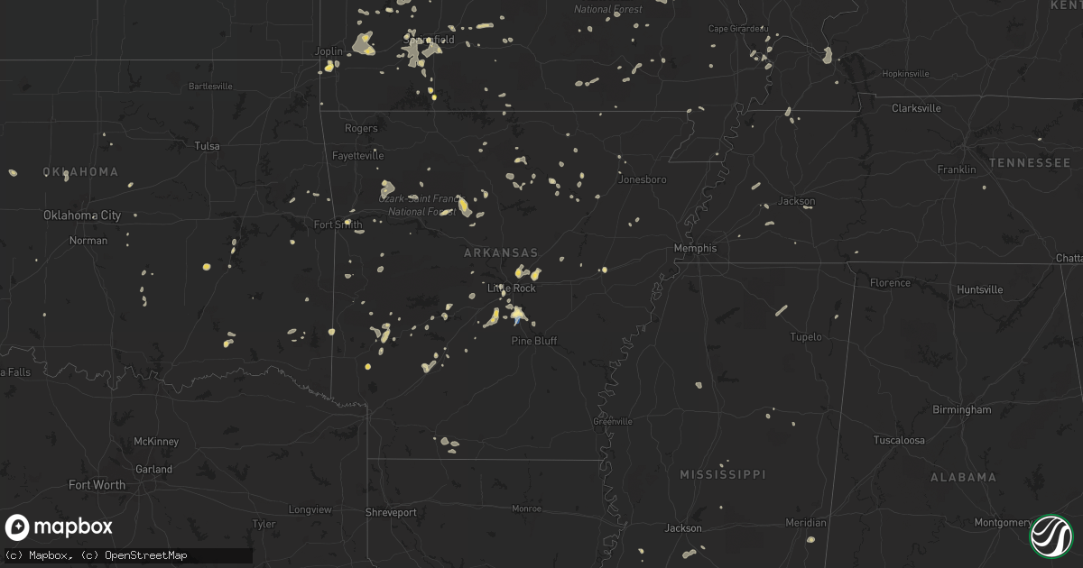
Hail Map in Arkansas on August 8, 2022
Get this storm
August 8 map
$229
one time, instant access
Download today. No call, no setup
Keep the $229
Bought the map and want the full workflow? Apply the entire $229 to a subscription within 7 days. None of it is wasted.
Every map, not just this one
This buys you this map. Subscription and you get every map we run, in the markets you choose from a few cities to whole states to nationwide. Plus real-time alerts the moment a storm fires.
Contact data
Name, contact info, occupancy, even credit band for addresses in the footprint. You go from where it hit to who to call.
Become the source they trust
Unlimited branding weather history reports on demand. You already have the documented answer ready for the property owner, and you are the one who showed up with it.
Property data and RoofTrace estimates
Pull up any address you have got, its value and the exact code rules for that jurisdiction, straight from One Click Code. Then RoofTrace estimates the squares, pitch, and roof value, priced the way you price.
Storm reports in Arkansas
Arkansas
| Date | Description |
|---|---|
| 08/08/20223:00 PM CDT | Some tree limbs were blown down. |
| 08/08/20222:43 PM CDT | Multiple power poles snapped along section line road across the mlk bypass from st. Vincent hospital on the southside of hot springs... Ar. |
| 08/08/20222:21 PM CDT | Multiple trees... Tree limbs... And tops of trees snapped in the hatcher road area near sherwood... Ar. |
| 08/08/20222:20 PM CDT | Trees and power lines down near the intersection of mlk bypass and central ave in the southern side of hot springs... Ar. |
| 08/08/20222:16 PM CDT | Large tree down across a fence in macon... Ar. |
| 08/08/20221:49 PM CDT | Large tree knocked down onto a home on west stoney pointe court in western little rock... Ar. |
| 08/08/20221:47 PM CDT | A large tree knocked over onto powerlines along napa valley drive on the western side of little rock... Ar. |
| 08/08/20221:45 PM CDT | Some trees and power lines were knocked down along highway 91 just north of egypt. |
| 08/08/202212:01 AM CDT | At 501 PM CDT, a severe thunderstorm was located near Mineral Springs, moving southeast at 10 mph. HAZARD...60 mph wind gusts and quarter size hail. SOURCE...Radar indicated. IMPACT...Hail damage to vehicles is expected. Expect wind damage to roofs, siding, and trees. Locations impacted include... Nashville and Mineral Springs. |
| 08/07/202211:42 PM CDT | At 442 PM CDT, a severe thunderstorm was located over Solo, or 25 miles northeast of Russellville, and is nearly stationary. HAZARD...60 mph wind gusts and nickel size hail. SOURCE...Radar indicated. IMPACT...Expect damage to roofs, siding, and trees. Locations impacted include... Solo... Dabney... Smyrna... Brock Creek Campground... Mountain Man Trailhead... Nogo... |
| 08/07/202210:13 PM CDT | At 313 PM CDT, severe thunderstorms were located along a line extending from near Cane Creek to near Redfield, moving southeast at 15 mph. HAZARD...60 mph wind gusts and quarter size hail. SOURCE...Radar indicated. IMPACT...Hail damage to vehicles is expected. Expect wind damage to roofs, siding, and trees. Locations impacted include... Redfield... Orion... Cane Creek... Hensley Island... East End... Pine Bluff Arsenal... Belfast... Hensley... Jefferson... Wright... Lock and Dam 5 Park... Kearney... Tar Camp Park... Ico... Woodson... F.B. Baugh Recreation Area... Shaw... |
| 08/07/20229:58 PM CDT | At 258 PM CDT, a severe thunderstorm was located near Cardiff, or 14 miles south of Booneville, moving east at 25 mph. HAZARD...60 mph wind gusts and quarter size hail. SOURCE...Radar indicated. IMPACT...Hail damage to vehicles is expected. Expect wind damage to roofs, siding, and trees. Locations impacted include... Booneville... Magazine... Blue Mountain... Stonehouse Recreation Area... Cardiff... Gravelly... Fourche Valley... Havana... Union Hill... Waveland... Olio... Waltreak... Bluffton... Nola... Harvey... Sugar Grove... Briggsville... Grayson... Blue Ball... |
| 08/07/20229:45 PM CDT | At 244 PM CDT, a severe thunderstorm was located near Norman, or 9 miles south of Mount Ida, drifting southwest around 10 mph. HAZARD...60 mph wind gusts and quarter size hail. SOURCE...Radar indicated. IMPACT...Hail damage to vehicles is expected. Expect wind damage to roofs, siding, and trees. Locations impacted include... Norman... Black Springs... Hopper... Fancyhill... Hurricane Grove... Caddo Gap... |
| 08/07/20229:30 PM CDT | At 230 PM CDT, severe thunderstorms were located along a line extending from near Lofton to Rockwell to near Hot Springs, moving northeast at 5 mph. HAZARD...60 mph wind gusts and quarter size hail. SOURCE...Radar indicated. IMPACT...Hail damage to vehicles is expected. Expect wind damage to roofs, siding, and trees. Locations impacted include... Hot Springs... Malvern... Mountain Pine... Rockport... Lonsdale... Hot Springs Memorial Field... Meyers... Rockwell... Hot Springs National Park... Magnet Cove... Red Oak... Oaklawn Racetrack... Sunshine... Royal... Lake Catherine State Park... Gulpha Gorge... Hempwallace... Pearcy... Crystal Springs... |
| 08/07/20229:08 PM CDT | At 208 PM CDT, a severe thunderstorm was located over Gravel Ridge, or over Little Rock AFB, moving southeast at 10 mph. HAZARD...60 mph wind gusts and quarter size hail. SOURCE...Radar indicated. IMPACT...Hail damage to vehicles is expected. Expect wind damage to roofs, siding, and trees. Locations impacted include... Little Rock... North Little Rock... Sherwood... Jacksonville... Little Rock AFB... North Little Rock Airport... Protho Junction... Gibson... Lakewood... Gravel Ridge... Sylvan Hills... Meto... McAlmont... South Bend... Olmstead... Camp Robinson... Baucum... Macon... Rose City... Indian Hills... |
All States Impacted by Hail Map on August 8, 2022
Cities Impacted by Hail Map on August 8, 2022
- Calico Rock, AR
- Van Buren, AR
- Alma, AR
- Noble, IL
- Ironton, MO
- Fredericktown, MO
- Villa Ridge, IL
- Pulaski, IL
- Olmsted, IL
- Oblong, IL
- Robinson, IL
- Walnut Grove, MO
- Morrisville, MO
- Des Arc, MO
- Yellville, AR
- Centerville, MO
- Golden City, MO
- Bunch, OK
- Hornbeak, TN
- Marshfield, MO
- South West City, MO
- Mountain View, AR
- Parma, MO
- Malden, MO
- Gideon, MO
- Dover, AR
- Pelsor, AR
- Bolivar, MO
- Brownsville, TN
- Cecil, AR
- Charleston, AR
- Lavaca, AR
- Fort Smith, AR
- Hereford, TX
- Martin, TN
- Diamond, MO
- Sarcoxie, MO
- Carthage, MO
- Miami, TX
- Joplin, MO
- Neosho, MO
- Stockton, MO
- Subiaco, AR
- Desha, AR
- Batesville, AR
- Witts Springs, AR
- Jerusalem, AR
- Hector, AR
- Deer, AR
- Parthenon, AR
- Sulphur Rock, AR
- Cord, AR
- Cave City, AR
- Fulton, KY
- South Fulton, TN
- Scheller, IL
- Waltonville, IL
- Sesser, IL
- Bauxite, AR
- Sheridan, AR
- Prattsville, AR
- Jackson, TN
- Beech Bluff, TN
- Pinson, TN
- Mountain Grove, MO
- Norwood, MO
- New Athens, IL
- Altamont, IL
- Effingham, IL
- Beecher City, IL
- Saint Elmo, IL
- Greenfield, MO
- Lockwood, MO
- Van Buren, MO
- El Dorado Springs, MO
- New Raymer, CO
- Grover, CO
- Weldona, CO
- Briggsdale, CO
- Gainesville, MO
- Amarillo, TX
- Mound City, IL
- Barlow, KY
- Aurora, MO
- Branson, MO
- Pampa, TX
- Hartville, MO
- Niangua, MO
- Grovespring, MO
- Campbell, MO
- Stilwell, OK
- Salem, MO
- Little Rock, AR
- Hensley, AR
- Clarksville, AR
- Ozone, AR
- Kosciusko, MS
- Kingman, AZ
- Galena, MO
- Highlandville, MO
- Ponce De Leon, MO
- Spokane, MO
- Sweetwater, OK
- Westcliffe, CO
- Gainesville, FL
- Congress, AZ
- Fairburn, GA
- Palmetto, GA
- Des Arc, AR
- Cape Coral, FL
- West Liberty, IL
- Watson, IL
- Ellington, MO
- Caseyville, IL
- East Saint Louis, IL
- Oran, MO
- Oklahoma City, OK
- Willard, MO
- Ash Grove, MO
- Bois D Arc, MO
- Springfield, MO
- Chestnut Mound, TN
- Elmwood, TN
- Strafford, MO
- Jerico Springs, MO
- Sheldon, MO
- Annapolis, MO
- Vulcan, MO
- Piedmont, MO
- Oakwood, OK
- Williamsville, MO
- Ozark, AR
- Elkins, AR
- Combs, AR
- Saint Paul, AR
- Chandler, OK
- Waynesville, MO
- Evening Shade, AR
- Half Way, MO
- Mount Airy, NC
- Du Bois, IL
- Lutz, FL
- Minden, LA
- Ada, OK
- Evergreen, AL
- Seligman, AZ
- Walnut Ridge, AR
- Realitos, TX
- Hot Springs National Park, AR
- Miller City, IL
- Charleston, MO
- Sidney, AR
- Watonga, OK
- Cherry Valley, AR
- Kingfisher, OK
- Clarkridge, AR
- Mountain Home, AR
- Fort Morgan, CO
- Farmington, MO
- Floral, AR
- Locust Grove, AR
- Rosie, AR
- Stotts City, MO
- Pierce City, MO
- La Russell, MO
- Miller, MO
- Avilla, MO
- Wentworth, MO
- Reeds, MO
- Mansfield, AR
- Grand Chain, IL
- Alton, MO
- Doniphan, MO
- Thornfield, MO
- Girard, KS
- Pittsburg, KS
- Seymour, MO
- Dadeville, MO
- Fair Play, MO
- Aldrich, MO
- Fifty Six, AR
- Briscoe, TX
- Cairo, IL
- Newport, AR
- Ellsinore, MO
- Grandin, MO
- Savannah, TN
- Tecumseh, OK
- Shawnee, OK
- Oakland, TN
- Somerville, TN
- Hollister, MO
- Timbo, AR
- Fox, AR
- Edgemont, AR
- Traskwood, AR
- Humansville, MO
- Dunnegan, MO
- Guffey, CO
- Ullin, IL
- Reeds Spring, MO
- Pocahontas, AR
- Mathiston, MS
- Ackerman, MS
- Saint Petersburg, FL
- Nashville, AR
- Mineral Springs, AR
- Gilbertsville, KY
- Perry, OK
- Bloomfield, MO
- Essex, MO
- Hardin, KY
- Benton, KY
- Clinton, AR
- Dennard, AR
- Seneca, MO
- Wyandotte, OK
- Rockville, IN
- Eufaula, OK
- Mcalester, OK
- Canadian, OK
- Vega, TX
- Konawa, OK
- Dumas, TX
- Starkville, MS
- Faunsdale, AL
- Gallion, AL
- Hodgen, OK
- Walnut Shade, MO
- Chestnutridge, MO
- Cutler, IL
- Hoxie, AR
- Nashville, IL
- Hoyleton, IL
- Newark, AR
- Folsom, NM
- Rogersville, MO
- Steele, MO
- Clever, MO
- Marionville, MO
- Billings, MO
- Republic, MO
- Brookline, MO
- Crane, MO
- Nixa, MO
- Bokoshe, OK
- Keota, OK
- Taloga, OK
- Putnam, OK
- Vian, OK
- Lamar, MO
- Ozark, MO
- Muldrow, OK
- Hattieville, AR
- Collins, MO
- Lenzburg, IL
- Deerfield, MO
- Fort Scott, KS
- Fayetteville, AR
- Hindsville, AR
- Mosquero, NM
- Oil Trough, AR
- Amity, AR
- Magnolia, AR
- Conchas Dam, NM
- Hornsby, TN
- Okolona, AR
- Arkadelphia, AR
- Meeker, OK
- Gurdon, AR
- Cherokee Village, AR
- Ash Flat, AR
- Christiana, TN
- Rockvale, TN
- Murfreesboro, TN
- Ina, IL
- Whittington, IL
- Julian, CA
- Boulevard, CA
- Arcadia, FL
- Sherrill, AR
- Antlers, OK
- Morgan, GA
- Crowder, OK
- Cleveland, AR
- Scotland, AR
- Norman, AR
- Mena, AR
- Thomasville, AL
- Waldron, AR
- Austin, AR
- Cabot, AR
- Lonoke, AR
- Jacksonville, AR
- Dragoon, AZ
- New Albany, MS
- San Manuel, AZ
- Broken Bow, OK
- Little Rock Air Force Base, AR
- Sherwood, AR
- Holcomb, MS
- El Dorado, AR
- Utica, MS
- Wheatley, AR
- Redfield, AR
- Punta Gorda, FL
- Clayton, NM
- Chino Valley, AZ
- Prescott, AZ
- Butler, AL
- Lisman, AL
- Mabelvale, AR
- Morton, MS
- Lena, MS
- Hot Springs Village, AR
- Malvern, AR
- Emerson, AR
- Roff, OK
- Fitzhugh, OK
- Cement, OK
- Chickasha, OK
- Perryville, AR
- Pearcy, AR
- Trenton, FL
- Bell, FL
- Port Charlotte, FL
- Hermanville, MS
- Payson, AZ
- Quitman, MS
- Meridian, MS
- Brinkley, AR
- Sells, AZ
- Bismarck, AR
- Langley, AR
- Umpire, AR
- Caddo Gap, AR
- Braxton, MS
- Brandon, MS
- Greenville, FL
- Madison, FL
- Valdosta, GA
- Quitman, GA
- Alexander, AR
- Hazlehurst, GA
- Denton, GA
- Mooringsport, LA
- Oil City, LA
- Glenwood, AR
- Kirby, AR
- Newhope, AR
- Lonsdale, AR
- Benton, AR
- Canyon, TX
- Maben, MS
- Palm Harbor, FL
- Oldsmar, FL
- Clearwater Beach, FL
- Jachin, AL
- Paducah, KY
- Brookport, IL
- Smithland, KY
- Ledbetter, KY
- Calvert City, KY
- Fulton, MS
- Golden, MS
- Crystal River, FL
- Corrigan, TX
- Stuart, OK
- Carthage, TX
- Baconton, GA
- Doerun, GA
- Flippin, AR
- Booneville, AR
- Sallis, MS
- Birch Tree, MO
- Cashion, OK
- Hennessey, OK
- Prescott, AR
- Valliant, OK
- Leola, AR
- Newnan, GA
- Myakka City, FL
- Wickes, AR
- Macomb, OK
- Florence, MS
- Selma, AL
- Marion Junction, AL
- Whiteville, TN
- Campo, CO
- Walsh, CO
- Monett, MO
- Benson, AZ
- Hudson, FL
- Sarasota, FL
- Watson, OK
- England, AR
- Tucker, AR
- Jefferson, AR
- Murfreesboro, AR
- San Jon, NM
- Grady, NM
- Happy, TX
- Animas, NM
- Wesley Chapel, FL
- Tampa, FL
- Land O'Lakes, FL
- Clayton, OK
- Snyder, TX
- Bonnerdale, AR
- Clayton, AL
- Seminole, FL
- Parrish, FL
- Alamo, TN
- Halls, TN
- Stillwater, OK
- Duncan, OK
- Chiefland, FL
- Stoneham, CO
- Lorain, OH
- Sheffield Lake, OH
- Amherst, OH
- Elyria, OH


