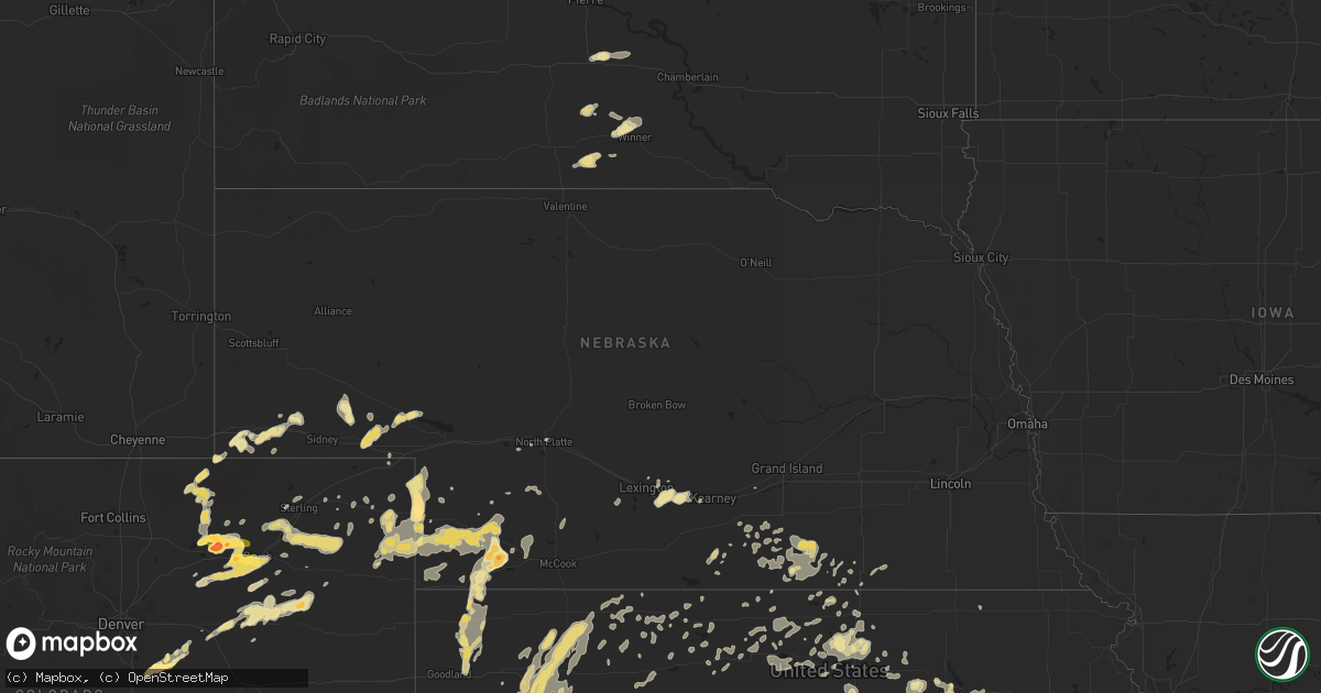
Hail Map in Nebraska on August 7, 2015
Get this storm
August 7 map
$229
one time, instant access
Download today. No call, no setup
Keep the $229
Bought the map and want the full workflow? Apply the entire $229 to a subscription within 7 days. None of it is wasted.
Every map, not just this one
This buys you this map. Subscription and you get every map we run, in the markets you choose from a few cities to whole states to nationwide. Plus real-time alerts the moment a storm fires.
Contact data
Name, contact info, occupancy, even credit band for addresses in the footprint. You go from where it hit to who to call.
Become the source they trust
Unlimited branding weather history reports on demand. You already have the documented answer ready for the property owner, and you are the one who showed up with it.
Property data and RoofTrace estimates
Pull up any address you have got, its value and the exact code rules for that jurisdiction, straight from One Click Code. Then RoofTrace estimates the squares, pitch, and roof value, priced the way you price.
Storm reports in Nebraska
Nebraska
| Date | Description |
|---|---|
| 08/07/201512:14 AM CDT | Winds estimated to be between 50 and 60 mph. |
| 08/07/201512:10 AM CDT | Report relayed by wfo oax...strong wind possibly associated with meso-vortex. |
| 08/06/201511:59 PM CDT | A local report indicates 58 MPH wind near 6 S GLENVIL |
| 08/06/201511:54 PM CDT | A local report indicates 60 MPH wind near 5 E AYR |
| 08/06/201511:40 PM CDT | Brief 60 mph gusts at i-80 exit...shook camper |
| 08/06/20159:35 PM CDT | Two rural electric poles were blown down. |
| 08/06/20159:30 PM CDT | Significant tree...utility pole and structural damage consistent with an intense downburst occurred in the eastern portions of palisade and adjacent areas south and eas |
| 08/06/20159:22 PM CDT | A local report indicates 1.75 inch wind near 7 NNW STRATTON NE |
| 08/06/20159:21 PM CDT | Wind gust snapped the top of an 80 foot tree. Top of tree flew over a house. Wind also flipped a swing set. House also shook because of the wind. |
| 08/06/20159:15 PM CDT | A local report indicates 75 MPH wind near 6 SW WAUNETA |
| 08/06/20159:15 PM CDT | Widespread and major tree damage throughout town consistent with an intense downburst. 12-18 inch diameter trees snapped and uprooted. Power outages in town and surroun |
| 08/06/20159:08 PM CDT | Wind gust estimate at 60-70 mph |
| 08/06/20159:01 PM CDT | A local report indicates 1.25 inch wind near 3 W ENDERS |
| 08/06/20158:52 PM CDT | A local report indicates 1.00 inch wind near 5 S CHAMPION |
| 08/06/20158:20 PM CDT | Small tree branches downed |
| 08/06/20158:05 PM CDT | Dime size hail also reported |
| 08/06/20157:53 PM CDT | A local report indicates 1.75 inch wind near 2 SW LAMAR |
All States Impacted by Hail Map on August 7, 2015
Cities Impacted by Hail Map on August 7, 2015
- Arthur, ND
- Hunter, ND
- Kathryn, ND
- Tower City, ND
- Buffalo, ND
- Valley City, ND
- Oriska, ND
- Wheatland, ND
- Fingal, ND
- Amenia, ND
- Galesburg, ND
- Lodgepole, NE
- Dalton, NE
- Woodrow, CO
- Palisade, NE
- Brush, CO
- Merino, CO
- Waverly, KS
- Welda, KS
- Colony, KS
- Westphalia, KS
- Garnett, KS
- Colby, KS
- Hillsboro, ND
- Wadena, MN
- Roseau, MN
- Grygla, MN
- Strathcona, MN
- Wannaska, MN
- Badger, MN
- Greenbush, MN
- Miller, SD
- Saint Lawrence, SD
- Topeka, KS
- Eudora, KS
- Lecompton, KS
- Wellsville, KS
- Baldwin City, KS
- Berryton, KS
- Ottawa, KS
- Tecumseh, KS
- Paola, KS
- Osawatomie, KS
- Lawrence, KS
- Rantoul, KS
- Edgerton, KS
- Wiggins, CO
- Roggen, CO
- Grover, CO
- Holyoke, CO
- Litchville, ND
- Marion, ND
- Borup, MN
- Park, KS
- Quinter, KS
- Franktown, CO
- Lisbon, ND
- Fort Ransom, ND
- Quenemo, KS
- Melvern, KS
- Haigler, NE
- Las Animas, CO
- Bird City, KS
- North Platte, NE
- Deweese, NE
- Glenvil, NE
- Lawrence, NE
- Bennett, CO
- Strasburg, CO
- Dix, NE
- Kimball, NE
- Northome, MN
- Mizpah, MN
- Gatzke, MN
- Middle River, MN
- Erie, ND
- Page, ND
- Argusville, ND
- Crawfordville, FL
- Bertrand, NE
- Lexington, NE
- Overton, NE
- Elm Creek, NE
- Smithfield, NE
- Selden, KS
- Atwood, KS
- Stratton, NE
- Wauneta, NE
- Benkelman, NE
- Williamsburg, KS
- Ulen, MN
- Champion, NE
- Sebeka, MN
- Pequot Lakes, MN
- Ironton, MN
- Verndale, MN
- Staples, MN
- Merrifield, MN
- Crosby, MN
- Brainerd, MN
- Nisswa, MN
- Pine River, MN
- Ellendale, ND
- Forbes, ND
- Sheridan Lake, CO
- Collyer, KS
- Utica, KS
- La Junta, CO
- New York Mills, MN
- Bluffton, MN
- Wray, CO
- Fort Morgan, CO
- Leoti, KS
- Winona, KS
- Grand Ridge, FL
- Greenwood, FL
- Sneads, FL
- Holstein, NE
- Monticello, FL
- Wakeeney, KS
- Newfolden, MN
- Thief River Falls, MN
- Coldwater, MS
- Burlingame, KS
- Hershey, NE
- Quincy, FL
- Belleville, KS
- Cawker City, KS
- Esbon, KS
- Clay Center, KS
- Hartford, KS
- Burlington, KS
- Presho, SD
- Norton, KS
- Live Oak, FL
- McAlpin, FL
- Prairie View, KS
- Logan, KS
- Bloomington, NE
- Gem, KS
- Dresden, KS
- Rexford, KS
- Monument, KS
- Oberlin, KS
- Jennings, KS
- Grinnell, KS
- Oakley, KS
- Grainfield, KS
- Hoxie, KS
- Norcatur, KS
- Mankato, KS
- Lebanon, KS
- Luverne, AL
- Rutledge, AL
- Honoraville, AL
- Manhattan, KS
- Harwood, ND
- Grant, NE
- Sardis, MS
- Batesville, MS
- Otis, CO
- Newport, AR
- Lamont, FL
- Atwood, CO
- Yuma, CO
- Snyder, CO
- Akron, CO
- Warroad, MN
- Weldona, CO
- Greenville, AL
- Max, NE
- Valdosta, GA
- Wendover, UT
- Phillipsburg, KS
- Ozark, AL
- Camden, AL
- McDonald, KS
- Blue Hill, NE
- Lyndon, KS
- Overbrook, KS
- Osage City, KS
- Vassar, KS
- Scranton, KS
- Oshkosh, NE
- Lewellen, NE
- Chappell, NE
- Ochlocknee, GA
- Coolidge, GA
- Meigs, GA
- Alma, KS
- Paxico, KS
- McFarland, KS
- Maple Hill, KS
- Wamego, KS
- Wood, SD
- Bradford, AR
- Smith Center, KS
- Morganville, KS
- Agar, SD
- Onida, SD
- Long Lake, SD
- Ashley, ND
- Leola, SD
- Bogue, KS
- Hill City, KS
- Bonifay, FL
- Tallahassee, FL
- Guide Rock, NE
- Superior, NE
- Elmore, AL
- Deatsville, AL
- Salol, MN
- Ree Heights, SD
- Glasco, KS
- Beloit, KS
- Mission, SD
- Dothan, AL
- Glade, KS
- Republic, KS
- Orient, SD
- Agenda, KS
- Edgeley, ND
- Carbondale, KS
- Deer Trail, CO
- Elizabeth, CO
- Dighton, KS
- Scandia, KS
- Millington, TN
- Solway, MN
- Shevlin, MN
- Bagley, MN
- Bemidji, MN
- Orchard, CO
- Briggsdale, CO
- Log Lane Village, CO
- Kersey, CO
- Chancellor, AL
- Coffee Springs, AL
- Titus, AL
- Bald Knob, AR
- Randall, KS
- Wynne, AR
- Parkin, AR
- Deshler, NE
- Byron, NE
- Clyde, KS
- Clifton, KS
- Mount Lemmon, AZ
- Floral, AR
- Beattie, KS
- Edson, KS
- Potter, NE
- Red Level, AL
- Andalusia, AL
- Concordia, KS
- Lindon, CO
- Blackduck, MN
- Wakefield, KS
- Benson, AZ
- Manila, AR
- Highland Home, AL
- Jamestown, KS
- Pavo, GA
- White Springs, FL
- Lake City, FL
- Bushnell, NE
- Thomasville, GA
- Minneapolis, KS
- Delphos, KS
- Haxtun, CO
- Imperial, NE
- Tuckerman, AR
- Gettysburg, SD
- Naponee, NE
- Hildreth, NE
- Ruskin, NE
- Davenport, NE
- Oak, NE
- Verona, ND
- Winner, SD
- Courtland, KS
- Perry, FL
- Kiowa, CO
- Georgetown, MN
- Felton, MN
- Hendrum, MN
- Perley, MN
- Gardner, ND
- Motley, MN
- Opp, AL
- Enders, NE
- Auburn, KS
- Senatobia, MS
- Goodland, KS
- Viking, MN
- Aurora, KS
- Norway, KS
- Adel, GA
- Ayr, NE
- Fleming, CO
- Amherst, CO
- Pine Apple, AL
- Vivian, SD
- Clayton, KS
- Lamoure, ND
- Berlin, ND
- Crenshaw, MS
- Como, MS
- Abbeville, AL
- Newville, AL
- Venango, NE
- Troy, AL
- Cottonwood, AL
- Riley, KS
- Donalsonville, GA
- Big Falls, MN
- Robinsonville, MS
- Tremont, MS
- Hamilton, AL
- Hernando, MS
- Oil Trough, AR
- Rosie, AR
- Magness, AR
- Greenville, FL
- Waterford, MS
- Holly Springs, MS
- Supai, AZ
- Georgiana, AL
- Bladen, NE
- Roseland, NE
- Harveyville, KS
- Lake Cormorant, MS
- Parks, NE
- Trenton, NE
- Julesburg, CO
- Minden, NE
- Campbell, NE
- Holly, CO
- San Carlos, AZ
- Peridot, AZ
- Kirwin, KS
- Squaw Lake, MN
- Northport, AL
- Berry, AL
- Tuscaloosa, AL
- Wellfleet, NE
- Dickens, NE
- Upland, NE
- Waskish, MN
- Cottondale, AL
- Woodston, KS
- Hickory Ridge, AR
- Nelson, NE
- Edgar, NE
- Fairfield, NE
- Marianna, FL
- Menahga, MN
- Livingston, AL
- York, AL
- Branford, FL
- Rocky Ford, CO
- Gove, KS
- Littlefield, AZ
- Heartwell, NE
- Boston, GA
- Freeport, FL
- Enderlin, ND
- Sheldon, ND
- Lancaster, MN
- McKenzie, AL
- Highmore, SD
- Forest Home, AL
- Portis, KS
- Downs, KS
- Osborne, KS
- Wood River, NE
- Defuniak Springs, FL
- Lenora, KS
- Eckley, CO
- Hayes Center, NE
- Saint Francis, KS
- Eustis, NE
- Deer River, MN
- Pomona, KS
- Le Roy, KS
- Saint George, KS
- Rossville, KS
- Belvue, KS
- Eskridge, KS
- Wakarusa, KS
- Lebo, KS
- Alta Vista, KS
- Junction City, KS
- Silver Lake, KS
- O'Brien, FL
- Caledonia, ND
- Chattahoochee, FL
- Hebron, NE
- Peterman, AL
- Evergreen, AL
- Turrell, AR
- Memphis, TN
- Wallace, NE
- Nesbit, MS
- Clio, AL
- Nome, ND
- Olive Branch, MS
- Byhalia, MS
- Vredenburgh, AL
- Beatrice, AL
- Fullerton, ND
- Shorterville, AL
- Caryville, FL
- Amagon, AR
- Chester, NE
- Fort Riley, KS
- Alton, KS
- Byers, CO
- Clarksdale, MS
- Dozier, AL
- Williams, AZ
- Prattville, AL
- Hahira, GA
- Hope, ND
- Clifford, ND
- Ponce De Leon, FL
- Tucson, AZ
- Sterling, CO
- Maywood, NE
- Augusta, AR
- Fulton, MS
- Almena, KS
- Abbeville, MS
- Naytahwaush, MN
- Mahnomen, MN
- Vernon, FL
- Judsonia, AR
- Pleasant Plains, AR
- Pelham, GA
- Kincaid, KS
- Boligee, AL
- Ray City, GA
- Nashville, GA
- Kearney, NE
- Skipperville, AL
- Bigfork, MN
- Lake City, AR
- Winslow, AZ
- Linden, AL
- McCrory, AR
- Parker, CO
- Curtis, NE
- Gurley, NE
- Broadwater, NE
- Baudette, MN
- Epes, AL
- Emelle, AL
- Kulm, ND
- Camilla, GA
- Stockton, KS
- Wirt, MN
- Simpson, KS
- Chipley, FL
- Moultrie, GA
- Hartsfield, GA
- Halstad, MN
- Shelly, MN
- Webber, KS
- Earle, AR
- Heth, AR
- Dixie, GA
- Barwick, GA
- Red Cloud, NE
- Hardy, NE
- Absaraka, ND
- Jewell, KS
- Burr Oak, KS
- Effie, MN
- Lake George, MN
- Park Rapids, MN
- Ideal, SD
- Witten, SD
- Magnolia, AL
- Thomaston, AL
- Morland, KS
- Dickey, ND
- Gaylord, KS
- Hosford, FL
- Kensington, KS
- Banner, MS
- Paris, MS
- Culbertson, NE
- Gilead, NE
- Fairbury, NE
- Hubbell, NE
- Max, MN
- Marbury, AL
- Paragould, AR
- Elaine, AR
- Glen Elder, KS
- Tipton, KS
- Clanton, AL
- Gallion, AL
- Fisher, AR
- Sidney, NE
- Wallace, KS
- Oxford, MS
- Formoso, KS
- Casselton, ND
- Kim, CO


