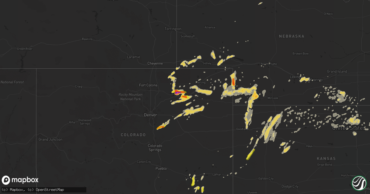
Hail Map on August 7, 2015
Get this storm
August 7 map
$229
one time, instant access
Download today. No call, no setup
Keep the $229
Bought the map and want the full workflow? Apply the entire $229 to a subscription within 7 days. None of it is wasted.
Every map, not just this one
This buys you this map. Subscription and you get every map we run, in the markets you choose from a few cities to whole states to nationwide. Plus real-time alerts the moment a storm fires.
Contact data
Name, contact info, occupancy, even credit band for addresses in the footprint. You go from where it hit to who to call.
Become the source they trust
Unlimited branding weather history reports on demand. You already have the documented answer ready for the property owner, and you are the one who showed up with it.
Property data and RoofTrace estimates
Pull up any address you have got, its value and the exact code rules for that jurisdiction, straight from One Click Code. Then RoofTrace estimates the squares, pitch, and roof value, priced the way you price.
States Impacted by Hail Map on August 7, 2015
Storm reports
New Mexico
| Date | Description |
|---|---|
| 08/07/20156:15 PM CDT | A local report indicates 69 MPH wind near 5 E EL MORRO |
Colorado
| Date | Description |
|---|---|
| 08/07/20156:45 PM CDT | Some roof damage. |
| 08/07/20156:42 PM CDT | A local report indicates 1.25 inch wind near 1 S FORT MORGAN |
| 08/07/20155:35 PM CDT | 2.25 diameter hail |
| 08/07/20155:33 PM CDT | A local report indicates 1.25 inch wind near 3 E WELDONA |
| 08/07/20155:17 PM CDT | A local report indicates 1.50 inch wind near 3 WNW ELIZABETH |
| 08/07/20155:12 PM CDT | A local report indicates 1.00 inch wind near 4 N ELIZABETH |
| 08/07/20155:03 PM CDT | A local report indicates 1.75 inch wind near 2 ENE FRANKTOWN |
| 08/07/20154:53 PM CDT | A local report indicates 1.00 inch wind near 1 WNW WELDONA |
| 08/07/20154:53 PM CDT | A local report indicates 1.00 inch wind near 3 E LA JUNTA |
| 08/07/20154:45 PM CDT | Actual measurement was 3.5 inches in diameter |
| 08/07/20154:30 PM CDT | A local report indicates 1.00 inch wind near JACKSON RESERVOIR |
| 08/07/20154:15 PM CDT | A local report indicates 1.75 inch wind near JACKSON RESERVOIR |
| 08/07/20154:07 PM CDT | A local report indicates 1.25 inch wind near 8 ESE HIGBEE |
| 08/07/20154:07 PM CDT | A local report indicates 65 MPH wind near 8 ESE HIGBEE |
| 08/07/20154:00 PM CDT | A local report indicates 1.00 inch wind near ELIZABETH |
| 08/06/20157:01 PM CDT | A local report indicates 1.00 inch wind near 1 SW BRUSH |
Florida
| Date | Description |
|---|---|
| 08/07/20156:30 PM CDT | Tree down on hardee road |
| 08/07/20156:19 PM CDT | Tree down along avalon road |
| 08/07/20156:12 PM CDT | Tree down on croatan street. |
| 08/07/20156:00 PM CDT | Large tree down near natural bridge road and old plank road |
| 08/07/20155:55 PM CDT | Trees down along sw 100th street. |
| 08/07/20155:45 PM CDT | Fhp reports tree in the road at natural bridge road and woodville highway |
| 08/07/20155:45 PM CDT | Tree down on wakulla springs rd north of highway 267. |
| 08/07/20155:45 PM CDT | Trees were blown across state road 26 near the gilchrist and alachua county line. |
| 08/07/20155:30 PM CDT | Trees were blown down along ne 80th and ne 24th loop. |
| 08/07/20155:10 PM CDT | A tree was blown down at 45th road and river run road. |
| 08/07/20155:10 PM CDT | Trees down in the western part of gadsden county |
| 08/07/20155:08 PM CDT | Tree and powerline down in douglass crossroads. |
| 08/07/20155:05 PM CDT | A tree was blown down across 288th street. |
| 08/07/20155:05 PM CDT | Trees down in the westbound lane of i-10 |
| 08/07/20155:00 PM CDT | A tree was blown down across the road at 1914 256th street. |
| 08/07/20154:55 PM CDT | A tree was blown down along sw 144th avenue. The time of damage was based on radar. |
| 08/07/20154:55 PM CDT | Trees were blown down along sw 73rd way. The time of damage was based on radar. |
| 08/07/20154:30 PM CDT | Trees were blown down along north bound highway 129 near obrien. |
| 08/07/20154:30 PM CDT | Power lines were blown down in a yard. |
| 08/07/20154:22 PM CDT | Trees were blown down along country club hammock road near county road 252. |
| 08/07/20154:15 PM CDT | Large limbs blown down at savannah circle and colquitt way. The time of damage was based on radar. |
| 08/07/20154:00 PM CDT | Power lines were blown down in a yard. |
| 08/07/20153:50 PM CDT | Tree down just n of white springs. Time estimated based on radar. |
| 08/07/20153:45 PM CDT | Trees down near genoa along hwy 41. Time estimated based on radar |
| 08/07/20153:30 PM CDT | Trees down near genoa along hwy 41. Time estimated based on radar |
| 08/07/20153:20 PM CDT | Four trees were blown down along 57th road south of 216th street. |
| 08/07/20153:17 PM CDT | Trees were blown across the road at 21412 51st drive. |
| 08/07/20153:15 PM CDT | Numerous large trees down across hwy 41 |
| 08/07/20152:10 PM CDT | St. Johns county 911/dispatch reports a powerline downed by thunderstorm wind gusts along greenbrier road. Time of damage based on radar data. |
| 08/07/20152:03 PM CDT | Tree down at cr 108 and 2 miles west of hwy 1 |
| 08/07/20152:00 PM CDT | A large tree was toppled by strong thunderstorm winds near the intersection of county roads 13 and 208. Time of damage based on radar data. |
| 08/07/20151:16 PM CDT | Tree down at cr 108 and 2 miles west of hwy 1 |
| 08/07/20151:00 PM CDT | Large tree down at 8100 w coralberry lane |
| 08/07/20151:00 PM CDT | Tree down on collins road between blanding blvd and roosevelt blvd |
| 08/06/20157:42 PM CDT | Tree down on county road 412 |
| 08/06/20157:20 PM CDT | Tree down on turlington lane |
North Dakota
| Date | Description |
|---|---|
| 08/07/20156:35 PM CDT | Measured 1.25 inches of rain and dime sized hail. Reported by nd arb observer |
| 08/07/20156:27 PM CDT | A poleshed roof was blown off and tumbled through the farmyard. It broke down a power pole and power line before coming to rest partially embedded in a farmhouse roof. |
| 08/07/20156:25 PM CDT | Large hail and strong winds occurred for several minutes. Drifts of hail were piled up against the side of a farmstead shop and in nearby ditches...and was still meltin |
| 08/07/20156:24 PM CDT | Large 1500 to 2000 pound hay bales were rolled for several hundred yards across fields...ditches and township roads. Time estimated based on radar. |
| 08/07/20156:20 PM CDT | Report and picture posted to social media. Time estimated based on radar. |
| 08/07/20156:15 PM CDT | Quarter to half dollar sized hail occurrerd for 2 to 3 minutes. Report and picture posted to social media. |
| 08/07/20156:11 PM CDT | Quarter to half dollar sized hail occurrerd for 2 to 3 minutes. Report and picture posted to social media. |
| 08/07/20156:10 PM CDT | Report and picture posted to social media. Time estimated based on radar. |
| 08/07/20156:08 PM CDT | Report and picture posted to social media. |
| 08/07/20155:59 PM CDT | Report and picture posted to social media. Time estimated based on radar. |
| 08/07/20155:48 PM CDT | A local report indicates 1.00 inch wind near 6 SSW MONANGO |
| 08/07/20155:45 PM CDT | A local report indicates 1.25 inch wind near 12 ESE MARION |
| 08/07/20154:45 PM CDT | Hail started at 445 pm and lasted to 450 pm. Most hail was pea sized with a few quarter sized. |
| 08/06/20158:10 PM CDT | A few dime to quarter sized hail and brief heavy rains. |
| 08/06/20157:05 PM CDT | A local report indicates 1.00 inch wind near 2 W ARGUSVILLE |
Alabama
| Date | Description |
|---|---|
| 08/07/20154:30 PM CDT | Power line down in samson |
| 08/07/20154:23 PM CDT | Trees down near county roads 625 and 655 |
| 08/07/20152:40 PM CDT | Tree down along county road 315 |
| 08/07/20152:33 PM CDT | Trees down on east county rd 36. |
| 08/07/20152:33 PM CDT | Tree down at county road 67 and county rd 339. |
| 08/07/20151:12 PM CDT | A few trees were blown down along highway 28 at coatopa. |
| 08/07/201512:49 PM CDT | A few trees were blwon down along highway 28 northwest of livingston. One tree was blocking the roadway. |
Mississippi
| Date | Description |
|---|---|
| 08/07/20159:58 AM CDT | Tree down on old tayor road at the mark apartments |
| 08/07/20159:55 AM CDT | Oxford em reports several trees down across city roads...cleanup in progress. |
| 08/07/20159:53 AM CDT | Trees downed on powerlines caused several power outages in oxford |
| 08/07/20159:39 AM CDT | Spotter reports 2 large trees uprooted. Measured 61 mph gust via anemometer |
Arizona
| Date | Description |
|---|---|
| 08/07/20156:30 PM CDT | Several large trees down gilbert to val vista rd in s gilbert - time estimated |
| 08/07/20156:27 PM CDT | A local report indicates 70 MPH wind near 4 ESE CHANDLER |
| 08/07/20155:50 PM CDT | Local police confirm brick wall collapse from strong tstorm wind in winslow. Time estimated from radar. |
| 08/07/20155:44 PM CDT | 8 in. Diameter tree blown down. |
| 08/07/20155:40 PM CDT | Local online newspaper media and fire department reported multiple thunderstorm wind damages including a roof blown off a house... A power line snapped on 9th st. And v |
| 08/07/20155:00 PM CDT | Roof blown off house and 2.5 ft. Diameter tree blown down. |
| 08/07/20155:00 PM CDT | 3 in. Diameter tree branches blown off. |
| 08/07/20153:30 PM CDT | Live wire blown down in residential area. Water covering roadway. Flooding in residential area |
| 08/07/20153:14 PM CDT | Measured at sasn carlos raws |
| 08/07/20153:14 PM CDT | 60 mph wind gust reported at san carlos mesonet site |
| 08/07/20153:00 PM CDT | Power pole down near lambert and camino de oeste |
Utah
| Date | Description |
|---|---|
| 08/07/20156:58 PM CDT | Aragonite raws |
| 08/07/20156:55 PM CDT | Lower cedar mtn |
| 08/07/20156:40 PM CDT | Playa station |
| 08/07/20156:20 PM CDT | A local report indicates 62 MPH wind near 12 W KNOLLS |
| 08/07/20156:20 PM CDT | Interstate 80 sensor |
| 08/07/20156:20 PM CDT | West granite |
| 08/07/20156:15 PM CDT | West of wildcat mountain sensor dpg24 |
| 08/07/20155:55 PM CDT | West salt flats sensor dpg26 |
| 08/07/20155:45 PM CDT | West salt flats sensor dpg26 |
| 08/07/20155:45 PM CDT | North salt flats sensor dpg25 |
| 08/07/20155:40 PM CDT | North salt flats sensor dpg25 |
| 08/07/20155:20 PM CDT | Wendover awos |
| 08/06/20158:55 PM CDT | Large trees down in henefer |
| 08/06/20158:45 PM CDT | A local report indicates 61 MPH wind near 5 ESE OGDEN |
| 08/06/20158:40 PM CDT | Sr-65 at big mountain pass |
| 08/06/20158:21 PM CDT | A local report indicates 65 MPH wind near 1 SW FARMINGTON |
| 08/06/20158:20 PM CDT | Parleys canyon at quarry |
| 08/06/20158:20 PM CDT | *** 2 inj *** finish line structure at tour of utah bike race collapsed injuring 2 people. |
| 08/06/20158:20 PM CDT | Centerville udot sensor |
| 08/06/20158:15 PM CDT | Great salt lake minerals |
| 08/06/20158:15 PM CDT | A local report indicates 61 MPH wind near 1 SSW FARMINGTON |
| 08/06/20158:10 PM CDT | A local report indicates 58 MPH wind near 4 E SALT LAKE CITY |
| 08/06/20157:53 PM CDT | Salt lake international airport |
| 08/06/20157:49 PM CDT | Great salt lake marina |
| 08/06/20157:45 PM CDT | Hat island |
| 08/06/20157:45 PM CDT | A local report indicates 60 MPH wind near 5 NE VERNON |
| 08/06/20157:40 PM CDT | Lake point i-80 sensor |
| 08/06/20157:30 PM CDT | Lakeside mountain |
| 08/06/20157:30 PM CDT | Uttr oasis compound |
| 08/06/20157:20 PM CDT | Portable rwis site |
| 08/06/20157:00 PM CDT | Camel back mountain |
| 08/06/20157:00 PM CDT | Diddle knoll |
Nevada
| Date | Description |
|---|---|
| 08/07/20154:30 PM CDT | Public reported via social media quarter size hail roughly 2 miles west of lages junction. Time estimated based off radar. |
| 08/07/20153:50 PM CDT | Tonopah airport measured peak wind of 50 knots. Likely outflow from nearby thunderstorms to the west |
Georgia
| Date | Description |
|---|---|
| 08/07/20155:50 PM CDT | Trees down on union church road |
| 08/07/20155:50 PM CDT | Trees down on old madison road |
| 08/07/20155:50 PM CDT | Trees down near highway 122 and 76 |
| 08/07/20155:45 PM CDT | Trees down near quitman |
| 08/07/20155:45 PM CDT | Trees down near pavo |
| 08/07/20155:42 PM CDT | Trees down near coolidge |
| 08/07/20154:08 PM CDT | Shed destoryed near highway 285 east of highway 39. |
| 08/07/20152:39 PM CDT | One residence had 6 to 7 trees blown down and many shingles blown off roof. |
| 08/07/20152:34 PM CDT | 60 reports of trees and powerlines down in valdosta and southern lowndes county. |
| 08/07/20152:30 PM CDT | Large tree on house on gornto rd. |
| 08/07/20152:15 PM CDT | Trees down near morven |
| 08/07/20152:15 PM CDT | Trees down along jackson road |
Arkansas
| Date | Description |
|---|---|
| 08/07/20158:13 AM CDT | Tree down west of wynne on hwy 64 near hwy 93 |
Kansas
| Date | Description |
|---|---|
| 08/07/20156:49 AM CDT | Several trees down 6-8 inches in diameter at 295th and bethel church. |
| 08/07/20155:02 AM CDT | A local report indicates 59 MPH wind near FORBES FIELD |
| 08/07/20155:00 AM CDT | Extensive tree damage near french middle school and south of 29th and fairlawn roads. |
| 08/07/20155:00 AM CDT | A local report indicates 65 MPH wind near 2 SW TOPEKA |
| 08/07/20154:58 AM CDT | A local report indicates 68 MPH wind near FORBES FIELD |
| 08/07/20154:55 AM CDT | Near 29th and eveningside. Time estimated from radar data. |
| 08/07/20154:50 AM CDT | Peak wind gusts estimated around 70 mph around 450 am cdt in the lake sherwood area of topeka. Extensive 2-4 inch tree limbs down in the lake sherwood area of southwest |
| 08/07/20154:48 AM CDT | Near 28th street and indian hills road |
| 08/07/20154:37 AM CDT | Trees snapped or uprooted. Time estimated from radar |
| 08/07/20154:22 AM CDT | A local report indicates 1.00 inch wind near 5 SE PAXICO |
| 08/07/20154:18 AM CDT | A local report indicates 65 MPH wind near 5 SE PAXICO |
| 08/07/20154:16 AM CDT | A local report indicates 70 MPH wind near 5 SE PAXICO |
| 08/07/20153:55 AM CDT | A local report indicates 60 MPH wind near 5 NW ALMA |
| 08/07/20153:32 AM CDT | Wind gust measured on weather instrument about a block east of ksu campus. |
| 08/07/20151:15 AM CDT | Spotter reported they had small hail around pea size with 60mph estimated wind gusts. Mostly tree damage with one 4 inch branch broken off. |
| 08/07/201512:50 AM CDT | 4 inch diameter tree limbs down. |
| 08/07/201512:50 AM CDT | A local report indicates 60 MPH wind near WNW MUNDEN |
| 08/07/201512:43 AM CDT | A local report indicates 60 MPH wind near 4 N BELLEVILLE |
| 08/07/201512:24 AM CDT | A local report indicates 61 MPH wind near HILL CITY |
| 08/07/201512:05 AM CDT | Kdot station. Exact time not avbl. Time est fm radar. |
| 08/06/201511:36 PM CDT | A local report indicates 62 MPH wind near SMITH CENTER AIRPORT |
| 08/06/20159:11 PM CDT | Estimated 60-70 mph wind gust...smashed window covering...marble sized hail |
| 08/06/20158:35 PM CDT | A local report indicates 82 MPH wind near OAKLEY |
| 08/06/20158:32 PM CDT | Quarter size hail...may be some slightly larger hail |
| 08/06/20158:30 PM CDT | Estimated 65-70 mph wind gust...zero visibility...blowing dust |
| 08/06/20158:29 PM CDT | Lots of live 5 inch tree limbs down. Dumpsters blown over. Minor vehicle and building damage from highs winds and hail. Power outage west of oakely for 2 hours. Delayed |
| 08/06/20158:29 PM CDT | A local report indicates 60 MPH wind near OAKLEY |
| 08/06/20157:57 PM CDT | A local report indicates 60 MPH wind near RUSSELL SPRINGS |
| 08/06/20157:22 PM CDT | A mix of penny and quarter hail...50 mph estimated wind gust and heavy rain |
| 08/06/20157:20 PM CDT | Blowing dust with near zero visibility |
Nebraska
| Date | Description |
|---|---|
| 08/07/201512:14 AM CDT | Winds estimated to be between 50 and 60 mph. |
| 08/07/201512:10 AM CDT | Report relayed by wfo oax...strong wind possibly associated with meso-vortex. |
| 08/06/201511:59 PM CDT | A local report indicates 58 MPH wind near 6 S GLENVIL |
| 08/06/201511:54 PM CDT | A local report indicates 60 MPH wind near 5 E AYR |
| 08/06/201511:40 PM CDT | Brief 60 mph gusts at i-80 exit...shook camper |
| 08/06/20159:35 PM CDT | Two rural electric poles were blown down. |
| 08/06/20159:30 PM CDT | Significant tree...utility pole and structural damage consistent with an intense downburst occurred in the eastern portions of palisade and adjacent areas south and eas |
| 08/06/20159:22 PM CDT | A local report indicates 1.75 inch wind near 7 NNW STRATTON NE |
| 08/06/20159:21 PM CDT | Wind gust snapped the top of an 80 foot tree. Top of tree flew over a house. Wind also flipped a swing set. House also shook because of the wind. |
| 08/06/20159:15 PM CDT | Widespread and major tree damage throughout town consistent with an intense downburst. 12-18 inch diameter trees snapped and uprooted. Power outages in town and surroun |
| 08/06/20159:15 PM CDT | A local report indicates 75 MPH wind near 6 SW WAUNETA |
| 08/06/20159:08 PM CDT | Wind gust estimate at 60-70 mph |
| 08/06/20159:01 PM CDT | A local report indicates 1.25 inch wind near 3 W ENDERS |
| 08/06/20158:52 PM CDT | A local report indicates 1.00 inch wind near 5 S CHAMPION |
| 08/06/20158:20 PM CDT | Small tree branches downed |
| 08/06/20158:05 PM CDT | Dime size hail also reported |
| 08/06/20157:53 PM CDT | A local report indicates 1.75 inch wind near 2 SW LAMAR |
Minnesota
| Date | Description |
|---|---|
| 08/06/20159:50 PM CDT | Brief heavy rains and a few large hail from dime to quarter sized. |
| 08/06/20159:19 PM CDT | Very heavy rains and occasional large hail were reported. Reports and pictures were also posted via social media. Hail occurred over a period of 3 to 5 minutes. |
| 08/06/20159:15 PM CDT | Very heavy rains and occasional large hail were reported. Hail occurred over a period of 3 to 5 minutes. |
| 08/06/20159:08 PM CDT | Report and pictures posted via social media. Time estimated based on radar. |
| 08/06/20159:00 PM CDT | Report and picture posted to social media. Time estimated based on radar. |
| 08/06/20158:45 PM CDT | A few 3 to 4 inch diameter branches broken down. Heavy rainfall of of 1.18 inches and some dime sized hail. |
| 08/06/20158:42 PM CDT | Reported via social media. Time estimated by radar. |
| 08/06/20158:40 PM CDT | Trees downed and roof damage reported via social media. Time estimated based on radar. |
| 08/06/20158:36 PM CDT | Reported via social media. Time estimated by radar. |
| 08/06/20158:35 PM CDT | Very heavy rains and strong winds were accompanied by intermittent large hail. |
| 08/06/20158:30 PM CDT | Trees downed and roof damage reported via social media. |
| 08/06/20157:45 PM CDT | Report and picture posted to social media. |
Cities Impacted by Hail Map on August 7, 2015
- Arthur, ND
- Hunter, ND
- Kathryn, ND
- Tower City, ND
- Buffalo, ND
- Valley City, ND
- Oriska, ND
- Wheatland, ND
- Fingal, ND
- Amenia, ND
- Galesburg, ND
- Lodgepole, NE
- Dalton, NE
- Woodrow, CO
- Palisade, NE
- Brush, CO
- Merino, CO
- Waverly, KS
- Welda, KS
- Colony, KS
- Westphalia, KS
- Garnett, KS
- Colby, KS
- Hillsboro, ND
- Wadena, MN
- Roseau, MN
- Grygla, MN
- Strathcona, MN
- Wannaska, MN
- Badger, MN
- Greenbush, MN
- Miller, SD
- Saint Lawrence, SD
- Topeka, KS
- Eudora, KS
- Lecompton, KS
- Wellsville, KS
- Baldwin City, KS
- Berryton, KS
- Ottawa, KS
- Tecumseh, KS
- Paola, KS
- Osawatomie, KS
- Lawrence, KS
- Rantoul, KS
- Edgerton, KS
- Wiggins, CO
- Roggen, CO
- Grover, CO
- Holyoke, CO
- Litchville, ND
- Marion, ND
- Borup, MN
- Park, KS
- Quinter, KS
- Franktown, CO
- Lisbon, ND
- Fort Ransom, ND
- Quenemo, KS
- Melvern, KS
- Haigler, NE
- Las Animas, CO
- Bird City, KS
- North Platte, NE
- Deweese, NE
- Glenvil, NE
- Lawrence, NE
- Bennett, CO
- Strasburg, CO
- Dix, NE
- Kimball, NE
- Northome, MN
- Mizpah, MN
- Gatzke, MN
- Middle River, MN
- Erie, ND
- Page, ND
- Argusville, ND
- Crawfordville, FL
- Bertrand, NE
- Lexington, NE
- Overton, NE
- Elm Creek, NE
- Smithfield, NE
- Selden, KS
- Atwood, KS
- Stratton, NE
- Wauneta, NE
- Benkelman, NE
- Williamsburg, KS
- Ulen, MN
- Champion, NE
- Sebeka, MN
- Pequot Lakes, MN
- Ironton, MN
- Verndale, MN
- Staples, MN
- Merrifield, MN
- Crosby, MN
- Brainerd, MN
- Nisswa, MN
- Pine River, MN
- Ellendale, ND
- Forbes, ND
- Sheridan Lake, CO
- Collyer, KS
- Utica, KS
- La Junta, CO
- New York Mills, MN
- Bluffton, MN
- Wray, CO
- Fort Morgan, CO
- Leoti, KS
- Winona, KS
- Grand Ridge, FL
- Greenwood, FL
- Sneads, FL
- Holstein, NE
- Monticello, FL
- Wakeeney, KS
- Newfolden, MN
- Thief River Falls, MN
- Coldwater, MS
- Burlingame, KS
- Hershey, NE
- Quincy, FL
- Belleville, KS
- Cawker City, KS
- Esbon, KS
- Clay Center, KS
- Hartford, KS
- Burlington, KS
- Presho, SD
- Norton, KS
- Live Oak, FL
- McAlpin, FL
- Prairie View, KS
- Logan, KS
- Bloomington, NE
- Gem, KS
- Dresden, KS
- Rexford, KS
- Monument, KS
- Oberlin, KS
- Jennings, KS
- Grinnell, KS
- Oakley, KS
- Grainfield, KS
- Hoxie, KS
- Norcatur, KS
- Mankato, KS
- Lebanon, KS
- Luverne, AL
- Rutledge, AL
- Honoraville, AL
- Manhattan, KS
- Harwood, ND
- Grant, NE
- Sardis, MS
- Batesville, MS
- Otis, CO
- Newport, AR
- Lamont, FL
- Atwood, CO
- Yuma, CO
- Snyder, CO
- Akron, CO
- Warroad, MN
- Weldona, CO
- Greenville, AL
- Max, NE
- Valdosta, GA
- Wendover, UT
- Phillipsburg, KS
- Ozark, AL
- Camden, AL
- McDonald, KS
- Blue Hill, NE
- Lyndon, KS
- Overbrook, KS
- Osage City, KS
- Vassar, KS
- Scranton, KS
- Oshkosh, NE
- Lewellen, NE
- Chappell, NE
- Ochlocknee, GA
- Coolidge, GA
- Meigs, GA
- Alma, KS
- Paxico, KS
- McFarland, KS
- Maple Hill, KS
- Wamego, KS
- Wood, SD
- Bradford, AR
- Smith Center, KS
- Morganville, KS
- Agar, SD
- Onida, SD
- Long Lake, SD
- Ashley, ND
- Leola, SD
- Bogue, KS
- Hill City, KS
- Bonifay, FL
- Tallahassee, FL
- Guide Rock, NE
- Superior, NE
- Elmore, AL
- Deatsville, AL
- Salol, MN
- Ree Heights, SD
- Glasco, KS
- Beloit, KS
- Mission, SD
- Dothan, AL
- Glade, KS
- Republic, KS
- Orient, SD
- Agenda, KS
- Edgeley, ND
- Carbondale, KS
- Deer Trail, CO
- Elizabeth, CO
- Dighton, KS
- Scandia, KS
- Millington, TN
- Solway, MN
- Shevlin, MN
- Bagley, MN
- Bemidji, MN
- Orchard, CO
- Briggsdale, CO
- Log Lane Village, CO
- Kersey, CO
- Chancellor, AL
- Coffee Springs, AL
- Titus, AL
- Bald Knob, AR
- Randall, KS
- Wynne, AR
- Parkin, AR
- Deshler, NE
- Byron, NE
- Clyde, KS
- Clifton, KS
- Mount Lemmon, AZ
- Floral, AR
- Beattie, KS
- Edson, KS
- Potter, NE
- Red Level, AL
- Andalusia, AL
- Concordia, KS
- Lindon, CO
- Blackduck, MN
- Wakefield, KS
- Benson, AZ
- Manila, AR
- Highland Home, AL
- Jamestown, KS
- Pavo, GA
- White Springs, FL
- Lake City, FL
- Bushnell, NE
- Thomasville, GA
- Minneapolis, KS
- Delphos, KS
- Haxtun, CO
- Imperial, NE
- Tuckerman, AR
- Gettysburg, SD
- Naponee, NE
- Hildreth, NE
- Ruskin, NE
- Davenport, NE
- Oak, NE
- Verona, ND
- Winner, SD
- Courtland, KS
- Perry, FL
- Kiowa, CO
- Georgetown, MN
- Felton, MN
- Hendrum, MN
- Perley, MN
- Gardner, ND
- Motley, MN
- Opp, AL
- Enders, NE
- Auburn, KS
- Senatobia, MS
- Goodland, KS
- Viking, MN
- Aurora, KS
- Norway, KS
- Adel, GA
- Ayr, NE
- Fleming, CO
- Amherst, CO
- Pine Apple, AL
- Vivian, SD
- Clayton, KS
- Lamoure, ND
- Berlin, ND
- Crenshaw, MS
- Como, MS
- Abbeville, AL
- Newville, AL
- Venango, NE
- Troy, AL
- Cottonwood, AL
- Riley, KS
- Donalsonville, GA
- Big Falls, MN
- Robinsonville, MS
- Tremont, MS
- Hamilton, AL
- Hernando, MS
- Oil Trough, AR
- Rosie, AR
- Magness, AR
- Greenville, FL
- Waterford, MS
- Holly Springs, MS
- Supai, AZ
- Georgiana, AL
- Bladen, NE
- Roseland, NE
- Harveyville, KS
- Lake Cormorant, MS
- Parks, NE
- Trenton, NE
- Julesburg, CO
- Minden, NE
- Campbell, NE
- Holly, CO
- San Carlos, AZ
- Peridot, AZ
- Kirwin, KS
- Squaw Lake, MN
- Northport, AL
- Berry, AL
- Tuscaloosa, AL
- Wellfleet, NE
- Dickens, NE
- Upland, NE
- Waskish, MN
- Cottondale, AL
- Woodston, KS
- Hickory Ridge, AR
- Nelson, NE
- Edgar, NE
- Fairfield, NE
- Marianna, FL
- Menahga, MN
- Livingston, AL
- York, AL
- Branford, FL
- Rocky Ford, CO
- Gove, KS
- Littlefield, AZ
- Heartwell, NE
- Boston, GA
- Freeport, FL
- Enderlin, ND
- Sheldon, ND
- Lancaster, MN
- McKenzie, AL
- Highmore, SD
- Forest Home, AL
- Portis, KS
- Downs, KS
- Osborne, KS
- Wood River, NE
- Defuniak Springs, FL
- Lenora, KS
- Eckley, CO
- Hayes Center, NE
- Saint Francis, KS
- Eustis, NE
- Deer River, MN
- Pomona, KS
- Le Roy, KS
- Saint George, KS
- Rossville, KS
- Belvue, KS
- Eskridge, KS
- Wakarusa, KS
- Lebo, KS
- Alta Vista, KS
- Junction City, KS
- Silver Lake, KS
- O'Brien, FL
- Caledonia, ND
- Chattahoochee, FL
- Hebron, NE
- Peterman, AL
- Evergreen, AL
- Turrell, AR
- Memphis, TN
- Wallace, NE
- Nesbit, MS
- Clio, AL
- Nome, ND
- Olive Branch, MS
- Byhalia, MS
- Vredenburgh, AL
- Beatrice, AL
- Fullerton, ND
- Shorterville, AL
- Caryville, FL
- Amagon, AR
- Chester, NE
- Fort Riley, KS
- Alton, KS
- Byers, CO
- Clarksdale, MS
- Dozier, AL
- Williams, AZ
- Prattville, AL
- Hahira, GA
- Hope, ND
- Clifford, ND
- Ponce De Leon, FL
- Tucson, AZ
- Sterling, CO
- Maywood, NE
- Augusta, AR
- Fulton, MS
- Almena, KS
- Abbeville, MS
- Naytahwaush, MN
- Mahnomen, MN
- Vernon, FL
- Judsonia, AR
- Pleasant Plains, AR
- Pelham, GA
- Kincaid, KS
- Boligee, AL
- Ray City, GA
- Nashville, GA
- Kearney, NE
- Skipperville, AL
- Bigfork, MN
- Lake City, AR
- Winslow, AZ
- Linden, AL
- McCrory, AR
- Parker, CO
- Curtis, NE
- Gurley, NE
- Broadwater, NE
- Baudette, MN
- Epes, AL
- Emelle, AL
- Kulm, ND
- Camilla, GA
- Stockton, KS
- Wirt, MN
- Simpson, KS
- Chipley, FL
- Moultrie, GA
- Hartsfield, GA
- Halstad, MN
- Shelly, MN
- Webber, KS
- Earle, AR
- Heth, AR
- Dixie, GA
- Barwick, GA
- Red Cloud, NE
- Hardy, NE
- Absaraka, ND
- Jewell, KS
- Burr Oak, KS
- Effie, MN
- Lake George, MN
- Park Rapids, MN
- Ideal, SD
- Witten, SD
- Magnolia, AL
- Thomaston, AL
- Morland, KS
- Dickey, ND
- Gaylord, KS
- Hosford, FL
- Kensington, KS
- Banner, MS
- Paris, MS
- Culbertson, NE
- Gilead, NE
- Fairbury, NE
- Hubbell, NE
- Max, MN
- Marbury, AL
- Paragould, AR
- Elaine, AR
- Glen Elder, KS
- Tipton, KS
- Clanton, AL
- Gallion, AL
- Fisher, AR
- Sidney, NE
- Wallace, KS
- Oxford, MS
- Formoso, KS
- Casselton, ND
- Kim, CO