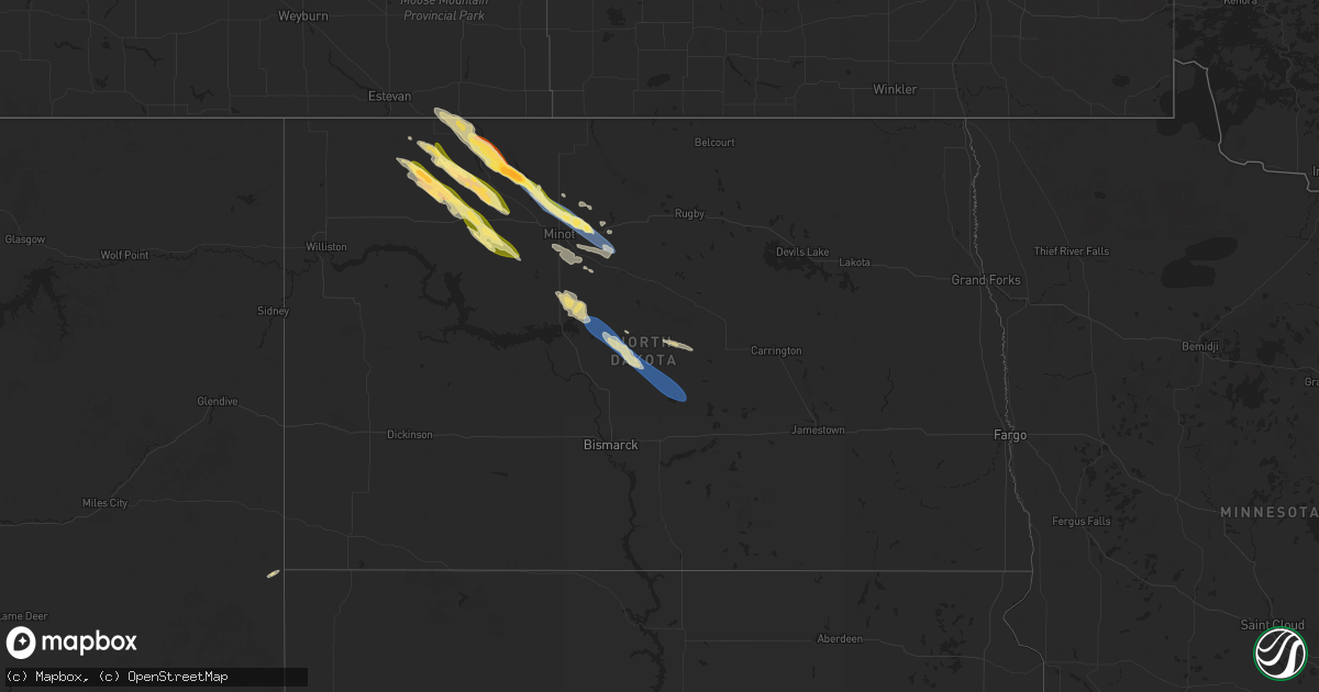
Hail Map in North Dakota on August 6, 2024
Get this storm
August 6 map
$229
one time, instant access
Download today. No call, no setup
Keep the $229
Bought the map and want the full workflow? Apply the entire $229 to a subscription within 7 days. None of it is wasted.
Every map, not just this one
This buys you this map. Subscription and you get every map we run, in the markets you choose from a few cities to whole states to nationwide. Plus real-time alerts the moment a storm fires.
Contact data
Name, contact info, occupancy, even credit band for addresses in the footprint. You go from where it hit to who to call.
Become the source they trust
Unlimited branding weather history reports on demand. You already have the documented answer ready for the property owner, and you are the one who showed up with it.
Property data and RoofTrace estimates
Pull up any address you have got, its value and the exact code rules for that jurisdiction, straight from One Click Code. Then RoofTrace estimates the squares, pitch, and roof value, priced the way you price.
Storm reports in North Dakota
North Dakota
| Date | Description |
|---|---|
| 08/06/20246:58 PM CDT | Delayed report from social media from august 6th. Estimated golf ball size... Destroyed a wheat field. |
| 08/06/20246:55 PM CDT | Delayed report from social media from august 6th. Picture of seven seed bins tipped over... Laying the same direction. Wind estimated at 80 mph. Time based on radar. |
| 08/06/20246:45 PM CDT | Delayed report from social media from august 6th. Pictures of hail and damage to house siding. Lasted 20 minutes. |
| 08/05/202410:57 PM CDT | 10-meter wind speed... Concurrent with 60 mph measurement at 3-meters. Ndawn station wing 8n. |
| 08/05/202410:15 PM CDT | Measured 10 meter wind gust at 4 n turtle lake ndawn station. 3 meter gust was 66 mph. |
| 08/05/202410:12 PM CDT | Delayed report from social media from august 6th. Picture of a center pivot irrigation system flipped. Estimated wind of 80 mph. Time based on radar. |
| 08/05/202410:10 PM CDT | Delayed social media report from august 6th. Picture of three large grain bins dented. Estimated 80 mph winds. Time based on radar. |
| 08/05/202410:09 PM CDT | 10-meter wind gust... With a 3-meter wind gust of 66 mph measured at 10:10 pm cdt. Ndawn station turtle lake 4n. |
| 08/05/202410:02 PM CDT | Delayed report from august 6th. Multiple homes on crooked lake have trees uprooted... Small sheds destroyed... Fences down... And pontoons flipped. Winds estimated at 7 |
| 08/05/20249:03 PM CDT | Delayed report from august 6th. Estimated 60mph winds with tree branches down. |
| 08/05/20248:37 PM CDT | Delayed report from social media from the evening of august 6th. Video of quarters to half dollar size hail... Lasted at least 5 minutes. |
| 08/05/20248:20 PM CDT | Photo relayed through broadcast media. |
| 08/05/20248:18 PM CDT | Delayed report from social media from storms august 6th. Also estimated 70mph winds. |
| 08/05/20248:00 PM CDT | Delayed report from august 6. Largest hailstones were quarter sized... With mostly pea and marble sized hail. |
| 08/05/20247:55 PM CDT | Awos station kmib minot afb. |
| 08/05/20247:55 PM CDT | Awos station kmib minot a |
| 08/05/20247:55 PM CDT | A local report indicates 68 MPH wind near 1 E Minot Air Force Bas |
| 08/05/20247:45 PM CDT | Delayed report from august 6. Time estimated from radar. |
| 08/05/20247:40 PM CDT | Hail lasted about 10 minutes. Also had 0.69 inch of rain. |
| 08/05/20247:34 PM CDT | Delayed report relayed by broadcast media from august 6th. Picture of hail. |
| 08/05/20247:34 PM CDT | Report from social media of nickel and quarter sized hail. |
| 08/05/20247:10 PM CDT | Delayed report from august 6 storms. Time estimated from radar. |
| 08/05/20247:05 PM CDT | Includes pictures of nickel and quarter sized hail piled up alongside a road. Also reports strong winds estimated to around 60 mph and crop damage. Relayed via social m |
| 08/05/20247:00 PM CDT | Delayed report from social media from august 6th. Roof blown off large steel barn... Walls damaged as well. |
All States Impacted by Hail Map on August 6, 2024
Cities Impacted by Hail Map on August 6, 2024
- Lawton, MI
- Marcellus, MI
- Decatur, MI
- Schoolcraft, MI
- Mendon, MI
- Three Rivers, MI
- Centreville, MI
- Sturgis, MI
- Bronson, MI
- Coldwater, MI
- Edon, OH
- West Unity, OH
- Archbold, OH
- Fayette, OH
- Mercer, PA
- Sharpsville, PA
- Hermitage, PA
- Sharon, PA
- Grove City, PA
- Boyers, PA
- Harrisville, PA
- Hilliards, PA
- Parker, PA
- Bruin, PA
- Petrolia, PA
- West Middlesex, PA
- Pulaski, PA
- New Wilmington, PA
- Karns City, PA
- East Brady, PA
- Rimersburg, PA
- Edinburg, PA
- New Castle, PA
- Volant, PA
- Templeton, PA
- New Bethlehem, PA
- Cowansville, PA
- Slippery Rock, PA
- Seminole, PA
- Adrian, PA
- Masury, OH
- Campbell, OH
- Lowellville, OH
- Youngstown, OH
- Dayton, PA
- Kittanning, PA
- Hartstown, PA
- Jamestown, PA
- Adamsville, PA
- West Sunbury, PA
- Butler, PA
- Portersville, PA
- Girard, OH
- Mineral Ridge, OH
- McDonald, OH
- Butler, IN
- Wampum, PA
- New Galilee, PA
- Ellwood City, PA
- Cochranton, PA
- Harmony, PA
- Smicksburg, PA
- Hadley, PA
- Clarks Mills, PA
- Stoneboro, PA
- Sandy Lake, PA
- Luthersburg, PA
- Sheakleyville, PA
- Edgerton, OH
- Bryan, OH
- Canfield, OH
- Marion Center, PA
- Rochester Mills, PA
- Grampian, PA
- Curwensville, PA
- Rockton, PA
- Prospect, PA
- Struthers, OH
- Home, PA
- Clearfield, PA
- Knox, PA
- Defiance, OH
- Ney, OH
- Ford City, PA
- Punxsutawney, PA
- Northpoint, PA
- Shelocta, PA
- Elderton, PA
- Rural Valley, PA
- Creekside, PA
- Indiana, PA
- Clymer, PA
- Morrisdale, PA
- Woodland, PA
- Mark Center, OH
- Sherwood, OH
- Pittsburgh, PA
- Renfrew, PA
- Napoleon, OH
- Hicksville, OH
- Salineville, OH
- Rossiter, PA
- Glen Campbell, PA
- Weston, OH
- Custar, OH
- Kylertown, PA
- Winburne, PA
- Lanse, PA
- Drifting, PA
- Grassflat, PA
- Philipsburg, PA
- Munson, PA
- Wellsville, OH
- Russellton, PA
- Cheswick, PA
- Creighton, PA
- Tarentum, PA
- Tyrone, PA
- Vandergrift, PA
- Penn Run, PA
- Apollo, PA
- Holgate, OH
- Deshler, OH
- McClure, OH
- Worthington, PA
- Cherry Tree, PA
- Allport, PA
- Warriors Mark, PA
- Hamler, OH
- Allison Park, PA
- Rudolph, OH
- Cabot, PA
- Moshannon, PA
- Murrysville, PA
- Export, PA
- Saltsburg, PA
- Malinta, OH
- Coalport, PA
- North Apollo, PA
- East Vandergrift, PA
- Bowling Green, OH
- Portage, OH
- Port Matilda, PA
- Brackenridge, PA
- Natrona Heights, PA
- West Decatur, PA
- Oakwood, OH
- Sarver, PA
- Grand Rapids, OH
- Snow Shoe, PA
- Julian, PA
- Fleming, PA
- Bellefonte, PA
- Beccaria, PA
- Freeport, PA
- Gibsonburg, OH
- Helena, OH
- Bradner, OH
- Cygnet, OH
- Wayne, OH
- Hawk Run, PA
- Osceola Mills, PA
- Willow Street, PA
- Lancaster, PA
- Patton, PA
- Fallentimber, PA
- Flinton, PA
- Lawrence Township, NJ
- Princeton Junction, NJ
- Washington Crossing, PA
- Trenton, NJ
- Morrisville, PA
- Fair Haven, NJ
- Atlantic Highlands, NJ
- Red Bank, NJ
- Rumson, NJ
- Jerry City, OH
- New Bavaria, OH
- Milton Center, OH
- Grelton, OH
- Pemberville, OH
- Leipsic, OH
- Avonmore, PA
- Cranberry Township, PA
- Fremont, OH
- Monmouth Beach, NJ
- Saxonburg, PA
- Evans City, PA
- Connoquenessing, PA
- Burgoon, OH
- Aliquippa, PA
- State College, PA
- Clune, PA
- McIntyre, PA
- Clarksburg, PA
- Slickville, PA
- Bloomdale, OH
- Bellevue, OH
- Green Springs, OH
- Clyde, OH
- Freedom, PA
- Conway, PA
- Ambridge, PA
- Conestoga, PA
- Millersville, PA
- Copiague, NY
- Amityville, NY
- Lindenhurst, NY
- Liberty Center, OH
- Cecil, OH
- McComb, OH
- Findlay, OH
- Arcadia, OH
- Fostoria, OH
- Van Buren, OH
- North Baltimore, OH
- Hoytville, OH
- Bascom, OH
- Tiffin, OH
- Kansas, OH
- Republic, OH
- Risingsun, OH
- Old Fort, OH
- West Millgrove, OH
- Bettsville, OH
- Lindsey, OH
- Vickery, OH
- Sandusky, OH
- Castalia, OH
- Monroeville, OH
- Milan, OH
- Huron, OH
- Norwalk, OH
- Vermilion, OH
- Lorain, OH
- Berlin Heights, OH
- Willard, OH
- Amherst, OH
- Greenwich, OH
- New London, OH
- Oberlin, OH
- Wakeman, OH
- Wellington, OH
- Kipton, OH
- Attica, OH
- Collins, OH
- North Fairfield, OH
- Elyria, OH
- Avon Lake, OH
- Avon, OH
- Sheffield Lake, OH
- Olmsted Falls, OH
- Cleveland, OH
- Grafton, OH
- Lagrange, OH
- Lakewood, OH
- North Ridgeville, OH
- Columbia Station, OH
- Brookpark, OH
- Westlake, OH
- Bay Village, OH
- Rocky River, OH
- Berea, OH
- North Olmsted, OH
- Spencer, OH
- Valley City, OH
- Medina, OH
- Brunswick, OH
- Litchfield, OH
- Strongsville, OH
- Altoona, PA
- Monroe Township, NJ
- Baden, PA
- Wexford, PA
- Sewickley, PA
- Washington Boro, PA
- Hollidaysburg, PA
- Long Branch, NJ
- Newtown, PA
- New Riegel, OH
- Englishtown, NJ
- Felton, PA
- Brogue, PA
- Alexandria, PA
- Sedona, AZ
- Millville, PA
- Ottawa, OH
- Titusville, NJ
- Independence, OH
- Maple Heights, OH
- Bedford, OH
- Pennsylvania Furnace, PA
- Milroy, PA
- Lewistown, PA
- McClure, PA
- Williamsburg, PA
- Bellwood, PA
- Orangeville, PA
- Stillwater, PA
- Benton, PA
- Airville, PA
- Broadview Heights, OH
- Northfield, OH
- Brecksville, OH
- Pennington, NJ
- Spruce Creek, PA
- Huntingdon, PA
- Petersburg, PA
- Reedsville, PA
- Ravenna, OH
- Akron, OH
- Twinsburg, OH
- Peninsula, OH
- Streetsboro, OH
- Macedonia, OH
- Richfield, OH
- Hinckley, OH
- Cuyahoga Falls, OH
- Mantua, OH
- Hudson, OH
- North Royalton, OH
- Solon, OH
- Kent, OH
- Munroe Falls, OH
- Aurora, OH
- Stow, OH
- Wadsworth, OH
- Hiram, OH
- Garrettsville, OH
- Beachwood, OH
- Windham, OH
- Newton Falls, OH
- Chagrin Falls, OH
- Wickliffe, OH
- Chesterland, OH
- Eastlake, OH
- Newbury, OH
- Novelty, OH
- Willoughby, OH
- Mentor, OH
- Burton, OH
- Chardon, OH
- Gates Mills, OH
- Euclid, OH
- West Farmington, OH
- Madison, OH
- Montville, OH
- Perry, OH
- Painesville, OH
- Grand River, OH
- Middlefield, OH
- Thompson, OH
- Huntsburg, OH
- Cortland, OH
- North Bloomfield, OH
- Geneva, OH
- Ashtabula, OH
- Rock Creek, OH
- Warren, OH
- Leavittsburg, OH
- Orwell, OH
- Windsor, OH
- Rome, OH
- Southington, OH
- Jefferson, OH
- Austinburg, OH
- Bristolville, OH
- Farmdale, OH
- Dorset, OH
- Conneaut, OH
- Pierpont, OH
- Williamsfield, OH
- Kingsville, OH
- Andover, OH
- North Kingsville, OH
- Miller City, OH
- Continental, OH
- Rawson, OH
- Alvada, OH
- Jenera, OH
- Pandora, OH
- Bluffton, OH
- Benton Ridge, OH
- Mount Cory, OH
- Arlington, OH
- Vanlue, OH
- Carey, OH
- Bloomville, OH
- Mogadore, OH
- Seville, OH
- Tallmadge, OH
- Barberton, OH
- Plymouth, OH
- Lakemore, OH
- Uniontown, OH
- Hubbard, OH
- Diamond, OH
- Deerfield, OH
- Niles, OH
- Hartville, OH
- North Jackson, OH
- Fowler, OH
- Rootstown, OH
- Vienna, OH
- Lake Milton, OH
- North Benton, OH
- Kinsman, OH
- Atwater, OH
- Berlin Center, OH
- Saxton, PA
- Mifflin, PA
- Port Royal, PA
- Mill Creek, PA
- Nogales, AZ
- Allensville, PA
- Hesston, PA
- Flemington, NJ
- McAlisterville, PA
- Richfield, PA
- Beaver Springs, PA
- Yeagertown, PA
- Mifflintown, PA
- Neshanic Station, NJ
- Annville, PA
- Grantville, PA
- Jonestown, PA
- Toms River, NJ
- New Rochelle, NY
- Monroeville, PA
- Palmyra, PA
- Mount Union, PA
- McVeytown, PA
- Shirleysburg, PA
- Fort Wayne, IN
- James Creek, PA
- Bridgewater, NJ
- Englewood Cliffs, NJ
- Whitehouse Station, NJ
- Three Bridges, NJ
- Hillsborough, NJ
- Somerville, NJ
- Oakland Mills, PA
- Basking Ridge, NJ
- Martinsville, NJ
- Belleville, PA
- Granville, PA
- Thompsontown, PA
- Cocolamus, PA
- Ono, PA
- Hummelstown, PA
- Fredericksburg, PA
- Jackson, WY
- Englewood, NJ
- East Waterford, PA
- Millerstown, PA
- Manchester Township, NJ
- Warren, NJ
- Millington, NJ
- Monroeville, IN
- Hoagland, IN
- Brookfield, OH
- Far Hills, NJ
- Dudley, PA
- Mamaroneck, NY
- Rye, NY
- Ringoes, NJ
- Robertsdale, PA
- Wells Tannery, PA
- Pine Grove, PA
- Mount Pleasant Mills, PA
- Liverpool, PA
- Millersburg, PA
- Dalmatia, PA
- Newport, PA
- Halifax, PA
- Burghill, OH
- Decatur, IN
- Waterfall, PA
- Stirling, NJ
- Bedminster, NJ
- New Haven, IN
- Walsenburg, CO
- Blairs Mills, PA
- Gillette, NJ
- Tenafly, NJ
- Salem, OH
- Beloit, OH
- Limaville, OH
- Alliance, OH
- North Lima, OH
- Leetonia, OH
- Columbiana, OH
- Farrell, PA
- Wheatland, PA
- Green Village, NJ
- New Vernon, NJ
- Chatham, NJ
- Elizabethville, PA
- Mechanicstown, OH
- Elliottsburg, PA
- Kensington, OH
- Carrollton, OH
- Muir, PA
- Tower City, PA
- Hustontown, PA
- Three Springs, PA
- Bernardsville, NJ
- Lykens, PA
- Rogers, OH
- Washingtonville, OH
- New Springfield, OH
- New Waterford, OH
- Negley, OH
- New Middletown, OH
- Petersburg, OH
- East Palestine, OH
- East Liverpool, OH
- Beaver Falls, PA
- Transfer, PA
- Beaver, PA
- Enon Valley, PA
- Hillsville, PA
- Linesville, PA
- Industry, PA
- Bessemer, PA
- Greenville, PA
- Darlington, PA
- Clark, PA
- West Pittsburg, PA
- Conneautville, PA
- Jackson Center, PA
- Berrysburg, PA
- Monaca, PA
- White Bird, ID
- Florham Park, NJ
- Madison, NJ
- Lysite, WY
- Midland, PA
- Morristown, NJ
- Harrisonville, PA
- Conneaut Lake, PA
- Saegertown, PA
- Atlantic, PA
- Springboro, PA
- Fredonia, PA
- West Springfield, PA
- Albion, PA
- Harmonsburg, PA
- Meadville, PA
- Meeteetse, WY
- Whitehall, MT
- Toronto, OH
- Chester, WV
- New Cumberland, WV
- Irondale, OH
- Newell, WV
- Hershey, PA
- Williamstown, PA
- Harrisburg, PA
- Rochester, PA
- Georgetown, PA
- Hookstown, PA
- Shippingport, PA
- Middletown, PA
- Elizabethtown, PA
- Bainbridge, PA
- Lisbon, OH
- Hammondsville, OH
- Morris Plains, NJ
- Shippensburg, PA
- Gardners, PA
- Newville, PA
- Walnut Bottom, PA
- East Rochester, OH
- Hanoverton, OH
- Biglerville, PA
- Manheim, PA
- Mount Joy, PA
- Lebanon, PA
- Wilson, WY
- Prescott Valley, AZ
- Canon City, CO
- Valencia, PA
- Fayetteville, PA
- Orrtanna, PA
- Guffey, CO
- Acton, MT
- Molt, MT
- Broadview, MT
- Emlenton, PA
- Denver, CO
- Cotopaxi, CO
- Elk City, ID
- Fenelton, PA
- Chicora, PA
- Belle Center, OH
- Huntsville, OH
- Albin, WY
- Meriden, WY
- Cheyenne, WY
- Pine, AZ
- Deer Lodge, MT
- Harrisburg, NE
- Carlton, PA
- Utica, PA
- Venus, PA
- Kennerdell, PA
- Titusville, PA
- Cranberry, PA
- Fryburg, PA
- Reno, PA
- Marble, PA
- Clintonville, PA
- Oil City, PA
- Polk, PA
- Seneca, PA
- Guys Mills, PA
- Eau Claire, PA
- Lucinda, PA
- Shippenville, PA
- Tionesta, PA
- Franklin, PA
- Cooperstown, PA
- Rouseville, PA
- Kossuth, PA
- Callensburg, PA
- Foxburg, PA
- Clarion, PA
- Sligo, PA
- Billings, MT
- Worland, WY
- Lagrange, WY
- Henderson, CO
- Gettysburg, PA
- Payson, AZ
- Bellefontaine, OH
- Commerce City, CO
- Manhattan, MT
- Bozeman, MT
- Prescott, AZ
- West Liberty, OH
- Zanesfield, OH
- Buffalo, WY
- Maplewood, OH
- Strattanville, PA
- Mayport, PA
- Corsica, PA
- Sigel, PA
- Brookville, PA
- Fairmount City, PA
- Summerville, PA
- Worthville, PA
- Coolspring, PA
- Timblin, PA
- Sprankle Mills, PA
- Ringgold, PA
- Hawthorn, PA
- Knox Dale, PA
- Huntley, MT
- Vail, AZ
- Sahuarita, AZ
- Romney, WV
- Gold Creek, MT
- Hardin, MT
- Bennett, CO
- Strasburg, CO
- Tucson, AZ
- Flaxton, ND
- Bowbells, ND
- Portal, ND
- Babb, MT
- Winslow, AZ
- Springfield, WV
- Burns, WY
- Sherwood, ND
- Kenmare, ND
- Frenchtown, MT
- Huson, MT
- Cut Bank, MT
- Browning, MT
- Spotswood, NJ
- Darby, MT
- Conner, MT
- Helena, MT
- Marysville, MT
- Elizabeth, CO
- Kiowa, CO
- Tolley, ND
- Lignite, ND
- Gillette, WY
- Crow Agency, MT
- Noonan, ND
- Canyon Creek, MT
- Pompeys Pillar, MT
- Saint Xavier, MT
- Garryowen, MT
- Lansford, ND
- Byers, CO
- Powers Lake, ND
- Donnybrook, ND
- Carpio, ND
- Holbrook, PA
- Casstown, OH
- Conover, OH
- Saint Paris, OH
- Aspers, PA
- Stanley, ND
- Columbus, ND
- New Freeport, PA
- Springfield, OH
- New Carlisle, OH
- Hamilton, MT
- Tonto Basin, AZ
- McLeod, MT
- Marana, AZ
- Agate, CO
- Philipsburg, MT
- Sula, MT
- Absarokee, MT
- Kingman, AZ
- Dauphin, PA
- Deer Trail, CO
- Glenburn, ND
- Berthold, ND
- Carpenter, WY
- Palermo, ND
- Minot Afb, ND
- Minot, ND
- Ramah, CO
- Columbus, MT
- Drummond, MT
- Fishtail, MT
- Joliet, MT
- Surrey, ND
- Norwich, ND
- Peach Springs, AZ
- Russells Point, OH
- Plaza, ND
- Makoti, ND
- Granville, ND
- Velva, ND
- Voltaire, ND
- Grover, CO
- Ryder, ND
- Polson, MT
- Deering, ND
- Sawyer, ND
- Ekalaka, MT
- Baker, MT
- Missoula, MT
- Briggsdale, CO
- Queen Creek, AZ
- Coleharbor, ND
- Benedict, ND
- Max, ND
- Turtle Lake, ND
- Maricopa, AZ
- Windsor, CO
- Severance, CO
- Brush, CO
- Gill, CO
- Kersey, CO
- Lindon, CO
- Hudson, CO
- Orchard, CO
- Hillrose, CO
- Keenesburg, CO
- Erie, CO
- Snyder, CO
- Greeley, CO
- New Raymer, CO
- Dacono, CO
- Frederick, CO
- Johnstown, CO
- Berthoud, CO
- Milliken, CO
- Pierce, CO
- Fort Lupton, CO
- Log Lane Village, CO
- Mead, CO
- Lucerne, CO
- Loveland, CO
- Gilcrest, CO
- Merino, CO
- Otis, CO
- Roggen, CO
- Carr, CO
- Akron, CO
- Fort Morgan, CO
- Padroni, CO
- Evans, CO
- Stoneham, CO
- Thornton, CO
- Broomfield, CO
- Weldona, CO
- Sterling, CO
- Wiggins, CO
- Eaton, CO
- Woodrow, CO
- Firestone, CO
- Platteville, CO
- Timnath, CO
- Wellington, CO
- Atwood, CO
- Fort Collins, CO
- Nunn, CO
- Brighton, CO
- Ault, CO
- La Salle, CO
- Galeton, CO
- Longmont, CO
- Gratz, PA
- Mercer, ND
- Mcclusky, ND
- Reed Point, MT
- Goodrich, ND
- Denhoff, ND
- Hurdsfield, ND
- Regan, ND
- Paradise Valley, AZ
- Scottsdale, AZ
- Wing, ND
- Tuttle, ND
- Florence, AZ
- Coolidge, AZ
- Pine Ridge, SD
- Manderson, SD
- Porcupine, SD
- New Kensington, PA
- Edgemont, SD
- Hot Springs, SD
- Custer, SD
- Wounded Knee, SD
- Batesland, SD
- Helmetta, NJ
- East Brunswick, NJ
- Little Falls, NJ
- Mohall, ND
- Ash, NC


