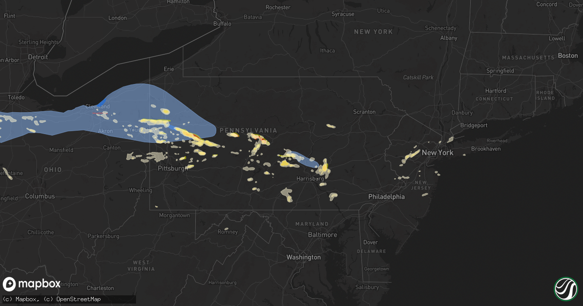
Hail Map in Pennsylvania on August 6, 2024
Get this storm
August 6 map
$229
one time, instant access
Download today. No call, no setup
Keep the $229
Bought the map and want the full workflow? Apply the entire $229 to a subscription within 7 days. None of it is wasted.
Every map, not just this one
This buys you this map. Subscription and you get every map we run, in the markets you choose from a few cities to whole states to nationwide. Plus real-time alerts the moment a storm fires.
Contact data
Name, contact info, occupancy, even credit band for addresses in the footprint. You go from where it hit to who to call.
Become the source they trust
Unlimited branding weather history reports on demand. You already have the documented answer ready for the property owner, and you are the one who showed up with it.
Property data and RoofTrace estimates
Pull up any address you have got, its value and the exact code rules for that jurisdiction, straight from One Click Code. Then RoofTrace estimates the squares, pitch, and roof value, priced the way you price.
Storm reports in Pennsylvania
Pennsylvania
| Date | Description |
|---|---|
| 08/06/20246:50 PM CDT | Tree down on sand hill rd |
| 08/06/20246:42 PM CDT | Trees down along moonlight ln |
| 08/06/20246:37 PM CDT | Tree down across rt 166. |
| 08/06/20246:35 PM CDT | Tree down |
| 08/06/20246:35 PM CDT | Tree down on n 3rd st |
| 08/06/20246:27 PM CDT | Roof of a home collapsed. Time estimated via radar. |
| 08/06/20246:25 PM CDT | Trees down |
| 08/06/20246:23 PM CDT | Tree down on fairbanks road near loaskie road. Time estimated via radar. |
| 08/06/20246:23 PM CDT | Tree down along county rd |
| 08/06/20246:23 PM CDT | Tree down at butler ave and route 156 |
| 08/06/20246:22 PM CDT | Power lines down along chambersville road. |
| 08/06/20246:03 PM CDT | Trees down. |
| 08/06/20246:03 PM CDT | Tree down on road |
| 08/06/20246:00 PM CDT | Trees down |
| 08/06/20245:42 PM CDT | Trees down. |
| 08/06/20245:37 PM CDT | A local report indicates 0 MPH wind near Arendtsville |
| 08/06/20245:37 PM CDT | Numerous reports of trees and wires down across adams county. |
| 08/06/20245:35 PM CDT | Numerous tree limbs down |
| 08/06/20245:30 PM CDT | Tree and wires down |
| 08/06/20245:27 PM CDT | Trees down. |
| 08/06/20245:20 PM CDT | Tree |
| 08/06/20245:20 PM CDT | Trees down |
| 08/06/20245:20 PM CDT | Trees down on fairview road |
| 08/06/20245:20 PM CDT | Numerous trees and wires down countywide |
| 08/06/20245:20 PM CDT | Tree and wires down |
| 08/06/20245:19 PM CDT | Multiple large limbs down along boyers rd and siding damage to marion twp vfd. |
| 08/06/20245:15 PM CDT | Trees down |
| 08/06/20245:14 PM CDT | Wind damage to mercer county courthouse clock. |
| 08/06/20245:12 PM CDT | Trees down. |
| 08/06/20245:07 PM CDT | Trees down |
| 08/06/20245:05 PM CDT | Trees down blocking roadway. |
| 08/06/20245:04 PM CDT | Trees down along fleming rd and nearby streets |
| 08/06/20245:03 PM CDT | Several trees down along route 173. |
| 08/06/20244:58 PM CDT | Trees uprooted or snapped. Relayed from mping |
| 08/06/20244:58 PM CDT | Trees uprooted or snapped. Relayed from mping. |
| 08/06/20244:55 PM CDT | Trees and wires down |
| 08/06/20244:54 PM CDT | Tree fell on home along lamor road. Picture provided. |
| 08/06/20244:51 PM CDT | Corrects previous tstm wnd dmg report from 1 n harrisburg. Trees down. |
| 08/06/20244:50 PM CDT | Large tree limbs down |
| 08/06/20244:48 PM CDT | Trees and wires down and blocking roadway. |
| 08/06/20244:47 PM CDT | Trees and wires down |
| 08/06/20244:43 PM CDT | Trees down on a house on lamor rd |
| 08/06/20244:40 PM CDT | Multiple trees and power lines down on lake road. Time estimated on radar. |
| 08/06/20244:40 PM CDT | Large tree limbs down |
| 08/06/20244:32 PM CDT | Trees and wires down in south shenango township. Time estimated via radar. |
| 08/06/20244:32 PM CDT | Trees and wires down in north shenango township. Time estimated via radar. |
| 08/06/20244:30 PM CDT | Trees down. |
| 08/06/20244:30 PM CDT | Ef-u landspout tornado was documented in photos. Damage is unknown at this time... Pending further information. Location was approximated from photographic perspective. |
| 08/06/20244:25 PM CDT | Trees down. |
| 08/06/20244:22 PM CDT | Corrects previous tstm wnd dmg report from 2 s newport. Trees down. |
| 08/06/20244:22 PM CDT | Trees down. |
| 08/06/20244:22 PM CDT | Trees down. |
| 08/06/20244:17 PM CDT | Tree down on state rt 72 at moonshine rd. |
| 08/06/20244:15 PM CDT | Corrects previous tstm wnd dmg report from liverpool. Trees down blocking roadway. |
| 08/06/20244:10 PM CDT | Ping pong ball sized hail leaving dents in some cars near monroe valley. |
| 08/06/20244:08 PM CDT | Corrects previous tstm wnd dmg report from 4 ne newport. Trees down. |
| 08/06/20243:54 PM CDT | Multiple trees down... Road closed. |
| 08/06/20243:40 PM CDT | Trees and wires down in the waterton area. |
| 08/06/20243:15 PM CDT | 4 trees down in huntingdon borough. |
| 08/06/20242:55 PM CDT | Multiple trees down in lancaster... Pequea... And west lampeter twps. |
| 08/06/20242:54 PM CDT | Trees down. |
| 08/06/20242:45 PM CDT | Trees down and on wires blocking old rt 220. |
| 08/06/20242:25 PM CDT | Tree down on a structure on peach bottom rd. |
| 08/06/20242:20 PM CDT | Trees and wires down on 3500 s eagle valley rd. |
| 08/06/20242:18 PM CDT | A local report indicates 1.00 inch wind near Port Matilda |
| 08/06/20242:10 PM CDT | Tree down along kummer road near hilltop drive. Time estimated via radar. |
| 08/06/20242:00 PM CDT | Trees and wires down. |
| 08/06/20241:56 PM CDT | Observed at 9th ave and prospect st |
| 08/06/20241:56 PM CDT | Tree limbs down on a house. |
| 08/06/20241:55 PM CDT | Several trees snapped. 4 trees uprooted |
| 08/06/20241:55 PM CDT | A local report indicates 1.00 inch wind near Tarentum |
| 08/06/20241:54 PM CDT | Trees and wires down in arnold. Time estimated via radar. |
| 08/06/20241:54 PM CDT | Multiple trees down at grassflat ave and reservoir rd. |
| 08/06/20241:53 PM CDT | Two-foot diameter tree down from thunderstorm wind |
| 08/06/20241:51 PM CDT | Shingles blown off roof and trees down along warren rd |
| 08/06/20241:47 PM CDT | Limbs down in camp deer creek |
| 08/06/20241:38 PM CDT | Report via mping |
| 08/06/20241:30 PM CDT | Dime- to quarter-size hail reported near the post office |
| 08/06/20241:30 PM CDT | Large limbs down |
| 08/06/20241:30 PM CDT | Large limbs broken. Reported via mping |
| 08/06/20241:30 PM CDT | Wires down |
| 08/06/20241:19 PM CDT | Tree down on kennedy road in prospect. Time estimated via radar. |
| 08/06/20241:15 PM CDT | Tree limbs down reported via mping |
| 08/06/20241:10 PM CDT | Trees down |
| 08/06/20241:10 PM CDT | Several trees and wires down |
| 08/06/202412:48 PM CDT | Downburst wind uprooted a number of walnut and oak trees along williamson rd |
| 08/06/202412:42 PM CDT | Several large tree limbs down |
| 08/06/202412:38 PM CDT | Two large trees down |
| 08/06/202412:38 PM CDT | Reported via mping |
| 08/06/202412:28 PM CDT | Tree on a home along gardner hill road. Picture provided. |
| 08/06/202412:25 PM CDT | Power pole and wires down |
| 08/06/202412:22 PM CDT | Trees and lines down across the county. Concentrated across boggs twp. |
| 08/06/202412:20 PM CDT | Several trees down |
| 08/06/202412:15 PM CDT | Trees and wires down |
| 08/06/202412:15 PM CDT | Trees down |
| 08/06/202412:10 PM CDT | Trees and wires down |
| 08/06/202412:07 PM CDT | Spiky hail reported along bingham rd |
| 08/06/202412:03 PM CDT | A local report indicates 1.25 inch wind near Templeton |
| 08/06/202411:59 AM CDT | Trees down along state route 36 |
| 08/06/202411:42 AM CDT | Trees down in vicinity of brady's bend from strong thunderstorm wind |
| 08/06/202411:40 AM CDT | Hail and very strong wind reported along seybertown rd |
| 08/06/202411:40 AM CDT | Along queenstown rd |
| 08/06/202411:39 AM CDT | Trees down along covered bridge rd |
| 08/06/202411:18 AM CDT | Multiple trees and power lines down near rt 227 and oleopolis rd. Time estimated via radar. |
| 08/06/202411:12 AM CDT | Trees down and a tree on a house. |
| 08/06/202411:09 AM CDT | Tree down along kennerdell road. Time estimated via radar. |
| 08/06/202410:57 AM CDT | Em reported 2 trees down near state highway 285. |
| 08/06/202410:39 AM CDT | Power lines down along mercer butler pike |
| 08/06/202410:38 AM CDT | Trees down |
| 08/06/202410:23 AM CDT | Trees down along s pitt st |
| 08/06/202410:22 AM CDT | Trees down. Car stuck between fallen trees along mercer new wilmington rd |
All States Impacted by Hail Map on August 6, 2024
Cities Impacted by Hail Map on August 6, 2024
- Lawton, MI
- Marcellus, MI
- Decatur, MI
- Schoolcraft, MI
- Mendon, MI
- Three Rivers, MI
- Centreville, MI
- Sturgis, MI
- Bronson, MI
- Coldwater, MI
- Edon, OH
- West Unity, OH
- Archbold, OH
- Fayette, OH
- Mercer, PA
- Sharpsville, PA
- Hermitage, PA
- Sharon, PA
- Grove City, PA
- Boyers, PA
- Harrisville, PA
- Hilliards, PA
- Parker, PA
- Bruin, PA
- Petrolia, PA
- West Middlesex, PA
- Pulaski, PA
- New Wilmington, PA
- Karns City, PA
- East Brady, PA
- Rimersburg, PA
- Edinburg, PA
- New Castle, PA
- Volant, PA
- Templeton, PA
- New Bethlehem, PA
- Cowansville, PA
- Slippery Rock, PA
- Seminole, PA
- Adrian, PA
- Masury, OH
- Campbell, OH
- Lowellville, OH
- Youngstown, OH
- Dayton, PA
- Kittanning, PA
- Hartstown, PA
- Jamestown, PA
- Adamsville, PA
- West Sunbury, PA
- Butler, PA
- Portersville, PA
- Girard, OH
- Mineral Ridge, OH
- McDonald, OH
- Butler, IN
- Wampum, PA
- New Galilee, PA
- Ellwood City, PA
- Cochranton, PA
- Harmony, PA
- Smicksburg, PA
- Hadley, PA
- Clarks Mills, PA
- Stoneboro, PA
- Sandy Lake, PA
- Luthersburg, PA
- Sheakleyville, PA
- Edgerton, OH
- Bryan, OH
- Canfield, OH
- Marion Center, PA
- Rochester Mills, PA
- Grampian, PA
- Curwensville, PA
- Rockton, PA
- Prospect, PA
- Struthers, OH
- Home, PA
- Clearfield, PA
- Knox, PA
- Defiance, OH
- Ney, OH
- Ford City, PA
- Punxsutawney, PA
- Northpoint, PA
- Shelocta, PA
- Elderton, PA
- Rural Valley, PA
- Creekside, PA
- Indiana, PA
- Clymer, PA
- Morrisdale, PA
- Woodland, PA
- Mark Center, OH
- Sherwood, OH
- Pittsburgh, PA
- Renfrew, PA
- Napoleon, OH
- Hicksville, OH
- Salineville, OH
- Rossiter, PA
- Glen Campbell, PA
- Weston, OH
- Custar, OH
- Kylertown, PA
- Winburne, PA
- Lanse, PA
- Drifting, PA
- Grassflat, PA
- Philipsburg, PA
- Munson, PA
- Wellsville, OH
- Russellton, PA
- Cheswick, PA
- Creighton, PA
- Tarentum, PA
- Tyrone, PA
- Vandergrift, PA
- Penn Run, PA
- Apollo, PA
- Holgate, OH
- Deshler, OH
- McClure, OH
- Worthington, PA
- Cherry Tree, PA
- Allport, PA
- Warriors Mark, PA
- Hamler, OH
- Allison Park, PA
- Rudolph, OH
- Cabot, PA
- Moshannon, PA
- Murrysville, PA
- Export, PA
- Saltsburg, PA
- Malinta, OH
- Coalport, PA
- North Apollo, PA
- East Vandergrift, PA
- Bowling Green, OH
- Portage, OH
- Port Matilda, PA
- Brackenridge, PA
- Natrona Heights, PA
- West Decatur, PA
- Oakwood, OH
- Sarver, PA
- Grand Rapids, OH
- Snow Shoe, PA
- Julian, PA
- Fleming, PA
- Bellefonte, PA
- Beccaria, PA
- Freeport, PA
- Gibsonburg, OH
- Helena, OH
- Bradner, OH
- Cygnet, OH
- Wayne, OH
- Hawk Run, PA
- Osceola Mills, PA
- Willow Street, PA
- Lancaster, PA
- Patton, PA
- Fallentimber, PA
- Flinton, PA
- Lawrence Township, NJ
- Princeton Junction, NJ
- Washington Crossing, PA
- Trenton, NJ
- Morrisville, PA
- Fair Haven, NJ
- Atlantic Highlands, NJ
- Red Bank, NJ
- Rumson, NJ
- Jerry City, OH
- New Bavaria, OH
- Milton Center, OH
- Grelton, OH
- Pemberville, OH
- Leipsic, OH
- Avonmore, PA
- Cranberry Township, PA
- Fremont, OH
- Monmouth Beach, NJ
- Saxonburg, PA
- Evans City, PA
- Connoquenessing, PA
- Burgoon, OH
- Aliquippa, PA
- State College, PA
- Clune, PA
- McIntyre, PA
- Clarksburg, PA
- Slickville, PA
- Bloomdale, OH
- Bellevue, OH
- Green Springs, OH
- Clyde, OH
- Freedom, PA
- Conway, PA
- Ambridge, PA
- Conestoga, PA
- Millersville, PA
- Copiague, NY
- Amityville, NY
- Lindenhurst, NY
- Liberty Center, OH
- Cecil, OH
- McComb, OH
- Findlay, OH
- Arcadia, OH
- Fostoria, OH
- Van Buren, OH
- North Baltimore, OH
- Hoytville, OH
- Bascom, OH
- Tiffin, OH
- Kansas, OH
- Republic, OH
- Risingsun, OH
- Old Fort, OH
- West Millgrove, OH
- Bettsville, OH
- Lindsey, OH
- Vickery, OH
- Sandusky, OH
- Castalia, OH
- Monroeville, OH
- Milan, OH
- Huron, OH
- Norwalk, OH
- Vermilion, OH
- Lorain, OH
- Berlin Heights, OH
- Willard, OH
- Amherst, OH
- Greenwich, OH
- New London, OH
- Oberlin, OH
- Wakeman, OH
- Wellington, OH
- Kipton, OH
- Attica, OH
- Collins, OH
- North Fairfield, OH
- Elyria, OH
- Avon Lake, OH
- Avon, OH
- Sheffield Lake, OH
- Olmsted Falls, OH
- Cleveland, OH
- Grafton, OH
- Lagrange, OH
- Lakewood, OH
- North Ridgeville, OH
- Columbia Station, OH
- Brookpark, OH
- Westlake, OH
- Bay Village, OH
- Rocky River, OH
- Berea, OH
- North Olmsted, OH
- Spencer, OH
- Valley City, OH
- Medina, OH
- Brunswick, OH
- Litchfield, OH
- Strongsville, OH
- Altoona, PA
- Monroe Township, NJ
- Baden, PA
- Wexford, PA
- Sewickley, PA
- Washington Boro, PA
- Hollidaysburg, PA
- Long Branch, NJ
- Newtown, PA
- New Riegel, OH
- Englishtown, NJ
- Felton, PA
- Brogue, PA
- Alexandria, PA
- Sedona, AZ
- Millville, PA
- Ottawa, OH
- Titusville, NJ
- Independence, OH
- Maple Heights, OH
- Bedford, OH
- Pennsylvania Furnace, PA
- Milroy, PA
- Lewistown, PA
- McClure, PA
- Williamsburg, PA
- Bellwood, PA
- Orangeville, PA
- Stillwater, PA
- Benton, PA
- Airville, PA
- Broadview Heights, OH
- Northfield, OH
- Brecksville, OH
- Pennington, NJ
- Spruce Creek, PA
- Huntingdon, PA
- Petersburg, PA
- Reedsville, PA
- Ravenna, OH
- Akron, OH
- Twinsburg, OH
- Peninsula, OH
- Streetsboro, OH
- Macedonia, OH
- Richfield, OH
- Hinckley, OH
- Cuyahoga Falls, OH
- Mantua, OH
- Hudson, OH
- North Royalton, OH
- Solon, OH
- Kent, OH
- Munroe Falls, OH
- Aurora, OH
- Stow, OH
- Wadsworth, OH
- Hiram, OH
- Garrettsville, OH
- Beachwood, OH
- Windham, OH
- Newton Falls, OH
- Chagrin Falls, OH
- Wickliffe, OH
- Chesterland, OH
- Eastlake, OH
- Newbury, OH
- Novelty, OH
- Willoughby, OH
- Mentor, OH
- Burton, OH
- Chardon, OH
- Gates Mills, OH
- Euclid, OH
- West Farmington, OH
- Madison, OH
- Montville, OH
- Perry, OH
- Painesville, OH
- Grand River, OH
- Middlefield, OH
- Thompson, OH
- Huntsburg, OH
- Cortland, OH
- North Bloomfield, OH
- Geneva, OH
- Ashtabula, OH
- Rock Creek, OH
- Warren, OH
- Leavittsburg, OH
- Orwell, OH
- Windsor, OH
- Rome, OH
- Southington, OH
- Jefferson, OH
- Austinburg, OH
- Bristolville, OH
- Farmdale, OH
- Dorset, OH
- Conneaut, OH
- Pierpont, OH
- Williamsfield, OH
- Kingsville, OH
- Andover, OH
- North Kingsville, OH
- Miller City, OH
- Continental, OH
- Rawson, OH
- Alvada, OH
- Jenera, OH
- Pandora, OH
- Bluffton, OH
- Benton Ridge, OH
- Mount Cory, OH
- Arlington, OH
- Vanlue, OH
- Carey, OH
- Bloomville, OH
- Mogadore, OH
- Seville, OH
- Tallmadge, OH
- Barberton, OH
- Plymouth, OH
- Lakemore, OH
- Uniontown, OH
- Hubbard, OH
- Diamond, OH
- Deerfield, OH
- Niles, OH
- Hartville, OH
- North Jackson, OH
- Fowler, OH
- Rootstown, OH
- Vienna, OH
- Lake Milton, OH
- North Benton, OH
- Kinsman, OH
- Atwater, OH
- Berlin Center, OH
- Saxton, PA
- Mifflin, PA
- Port Royal, PA
- Mill Creek, PA
- Nogales, AZ
- Allensville, PA
- Hesston, PA
- Flemington, NJ
- McAlisterville, PA
- Richfield, PA
- Beaver Springs, PA
- Yeagertown, PA
- Mifflintown, PA
- Neshanic Station, NJ
- Annville, PA
- Grantville, PA
- Jonestown, PA
- Toms River, NJ
- New Rochelle, NY
- Monroeville, PA
- Palmyra, PA
- Mount Union, PA
- McVeytown, PA
- Shirleysburg, PA
- Fort Wayne, IN
- James Creek, PA
- Bridgewater, NJ
- Englewood Cliffs, NJ
- Whitehouse Station, NJ
- Three Bridges, NJ
- Hillsborough, NJ
- Somerville, NJ
- Oakland Mills, PA
- Basking Ridge, NJ
- Martinsville, NJ
- Belleville, PA
- Granville, PA
- Thompsontown, PA
- Cocolamus, PA
- Ono, PA
- Hummelstown, PA
- Fredericksburg, PA
- Jackson, WY
- Englewood, NJ
- East Waterford, PA
- Millerstown, PA
- Manchester Township, NJ
- Warren, NJ
- Millington, NJ
- Monroeville, IN
- Hoagland, IN
- Brookfield, OH
- Far Hills, NJ
- Dudley, PA
- Mamaroneck, NY
- Rye, NY
- Ringoes, NJ
- Robertsdale, PA
- Wells Tannery, PA
- Pine Grove, PA
- Mount Pleasant Mills, PA
- Liverpool, PA
- Millersburg, PA
- Dalmatia, PA
- Newport, PA
- Halifax, PA
- Burghill, OH
- Decatur, IN
- Waterfall, PA
- Stirling, NJ
- Bedminster, NJ
- New Haven, IN
- Walsenburg, CO
- Blairs Mills, PA
- Gillette, NJ
- Tenafly, NJ
- Salem, OH
- Beloit, OH
- Limaville, OH
- Alliance, OH
- North Lima, OH
- Leetonia, OH
- Columbiana, OH
- Farrell, PA
- Wheatland, PA
- Green Village, NJ
- New Vernon, NJ
- Chatham, NJ
- Elizabethville, PA
- Mechanicstown, OH
- Elliottsburg, PA
- Kensington, OH
- Carrollton, OH
- Muir, PA
- Tower City, PA
- Hustontown, PA
- Three Springs, PA
- Bernardsville, NJ
- Lykens, PA
- Rogers, OH
- Washingtonville, OH
- New Springfield, OH
- New Waterford, OH
- Negley, OH
- New Middletown, OH
- Petersburg, OH
- East Palestine, OH
- East Liverpool, OH
- Beaver Falls, PA
- Transfer, PA
- Beaver, PA
- Enon Valley, PA
- Hillsville, PA
- Linesville, PA
- Industry, PA
- Bessemer, PA
- Greenville, PA
- Darlington, PA
- Clark, PA
- West Pittsburg, PA
- Conneautville, PA
- Jackson Center, PA
- Berrysburg, PA
- Monaca, PA
- White Bird, ID
- Florham Park, NJ
- Madison, NJ
- Lysite, WY
- Midland, PA
- Morristown, NJ
- Harrisonville, PA
- Conneaut Lake, PA
- Saegertown, PA
- Atlantic, PA
- Springboro, PA
- Fredonia, PA
- West Springfield, PA
- Albion, PA
- Harmonsburg, PA
- Meadville, PA
- Meeteetse, WY
- Whitehall, MT
- Toronto, OH
- Chester, WV
- New Cumberland, WV
- Irondale, OH
- Newell, WV
- Hershey, PA
- Williamstown, PA
- Harrisburg, PA
- Rochester, PA
- Georgetown, PA
- Hookstown, PA
- Shippingport, PA
- Middletown, PA
- Elizabethtown, PA
- Bainbridge, PA
- Lisbon, OH
- Hammondsville, OH
- Morris Plains, NJ
- Shippensburg, PA
- Gardners, PA
- Newville, PA
- Walnut Bottom, PA
- East Rochester, OH
- Hanoverton, OH
- Biglerville, PA
- Manheim, PA
- Mount Joy, PA
- Lebanon, PA
- Wilson, WY
- Prescott Valley, AZ
- Canon City, CO
- Valencia, PA
- Fayetteville, PA
- Orrtanna, PA
- Guffey, CO
- Acton, MT
- Molt, MT
- Broadview, MT
- Emlenton, PA
- Denver, CO
- Cotopaxi, CO
- Elk City, ID
- Fenelton, PA
- Chicora, PA
- Belle Center, OH
- Huntsville, OH
- Albin, WY
- Meriden, WY
- Cheyenne, WY
- Pine, AZ
- Deer Lodge, MT
- Harrisburg, NE
- Carlton, PA
- Utica, PA
- Venus, PA
- Kennerdell, PA
- Titusville, PA
- Cranberry, PA
- Fryburg, PA
- Reno, PA
- Marble, PA
- Clintonville, PA
- Oil City, PA
- Polk, PA
- Seneca, PA
- Guys Mills, PA
- Eau Claire, PA
- Lucinda, PA
- Shippenville, PA
- Tionesta, PA
- Franklin, PA
- Cooperstown, PA
- Rouseville, PA
- Kossuth, PA
- Callensburg, PA
- Foxburg, PA
- Clarion, PA
- Sligo, PA
- Billings, MT
- Worland, WY
- Lagrange, WY
- Henderson, CO
- Gettysburg, PA
- Payson, AZ
- Bellefontaine, OH
- Commerce City, CO
- Manhattan, MT
- Bozeman, MT
- Prescott, AZ
- West Liberty, OH
- Zanesfield, OH
- Buffalo, WY
- Maplewood, OH
- Strattanville, PA
- Mayport, PA
- Corsica, PA
- Sigel, PA
- Brookville, PA
- Fairmount City, PA
- Summerville, PA
- Worthville, PA
- Coolspring, PA
- Timblin, PA
- Sprankle Mills, PA
- Ringgold, PA
- Hawthorn, PA
- Knox Dale, PA
- Huntley, MT
- Vail, AZ
- Sahuarita, AZ
- Romney, WV
- Gold Creek, MT
- Hardin, MT
- Bennett, CO
- Strasburg, CO
- Tucson, AZ
- Flaxton, ND
- Bowbells, ND
- Portal, ND
- Babb, MT
- Winslow, AZ
- Springfield, WV
- Burns, WY
- Sherwood, ND
- Kenmare, ND
- Frenchtown, MT
- Huson, MT
- Cut Bank, MT
- Browning, MT
- Spotswood, NJ
- Darby, MT
- Conner, MT
- Helena, MT
- Marysville, MT
- Elizabeth, CO
- Kiowa, CO
- Tolley, ND
- Lignite, ND
- Gillette, WY
- Crow Agency, MT
- Noonan, ND
- Canyon Creek, MT
- Pompeys Pillar, MT
- Saint Xavier, MT
- Garryowen, MT
- Lansford, ND
- Byers, CO
- Powers Lake, ND
- Donnybrook, ND
- Carpio, ND
- Holbrook, PA
- Casstown, OH
- Conover, OH
- Saint Paris, OH
- Aspers, PA
- Stanley, ND
- Columbus, ND
- New Freeport, PA
- Springfield, OH
- New Carlisle, OH
- Hamilton, MT
- Tonto Basin, AZ
- McLeod, MT
- Marana, AZ
- Agate, CO
- Philipsburg, MT
- Sula, MT
- Absarokee, MT
- Kingman, AZ
- Dauphin, PA
- Deer Trail, CO
- Glenburn, ND
- Berthold, ND
- Carpenter, WY
- Palermo, ND
- Minot Afb, ND
- Minot, ND
- Ramah, CO
- Columbus, MT
- Drummond, MT
- Fishtail, MT
- Joliet, MT
- Surrey, ND
- Norwich, ND
- Peach Springs, AZ
- Russells Point, OH
- Plaza, ND
- Makoti, ND
- Granville, ND
- Velva, ND
- Voltaire, ND
- Grover, CO
- Ryder, ND
- Polson, MT
- Deering, ND
- Sawyer, ND
- Ekalaka, MT
- Baker, MT
- Missoula, MT
- Briggsdale, CO
- Queen Creek, AZ
- Coleharbor, ND
- Benedict, ND
- Max, ND
- Turtle Lake, ND
- Maricopa, AZ
- Windsor, CO
- Severance, CO
- Brush, CO
- Gill, CO
- Kersey, CO
- Lindon, CO
- Hudson, CO
- Orchard, CO
- Hillrose, CO
- Keenesburg, CO
- Erie, CO
- Snyder, CO
- Greeley, CO
- New Raymer, CO
- Dacono, CO
- Frederick, CO
- Johnstown, CO
- Berthoud, CO
- Milliken, CO
- Pierce, CO
- Fort Lupton, CO
- Log Lane Village, CO
- Mead, CO
- Lucerne, CO
- Loveland, CO
- Gilcrest, CO
- Merino, CO
- Otis, CO
- Roggen, CO
- Carr, CO
- Akron, CO
- Fort Morgan, CO
- Padroni, CO
- Evans, CO
- Stoneham, CO
- Thornton, CO
- Broomfield, CO
- Weldona, CO
- Sterling, CO
- Wiggins, CO
- Eaton, CO
- Woodrow, CO
- Firestone, CO
- Platteville, CO
- Timnath, CO
- Wellington, CO
- Atwood, CO
- Fort Collins, CO
- Nunn, CO
- Brighton, CO
- Ault, CO
- La Salle, CO
- Galeton, CO
- Longmont, CO
- Gratz, PA
- Mercer, ND
- Mcclusky, ND
- Reed Point, MT
- Goodrich, ND
- Denhoff, ND
- Hurdsfield, ND
- Regan, ND
- Paradise Valley, AZ
- Scottsdale, AZ
- Wing, ND
- Tuttle, ND
- Florence, AZ
- Coolidge, AZ
- Pine Ridge, SD
- Manderson, SD
- Porcupine, SD
- New Kensington, PA
- Edgemont, SD
- Hot Springs, SD
- Custer, SD
- Wounded Knee, SD
- Batesland, SD
- Helmetta, NJ
- East Brunswick, NJ
- Little Falls, NJ
- Mohall, ND
- Ash, NC


