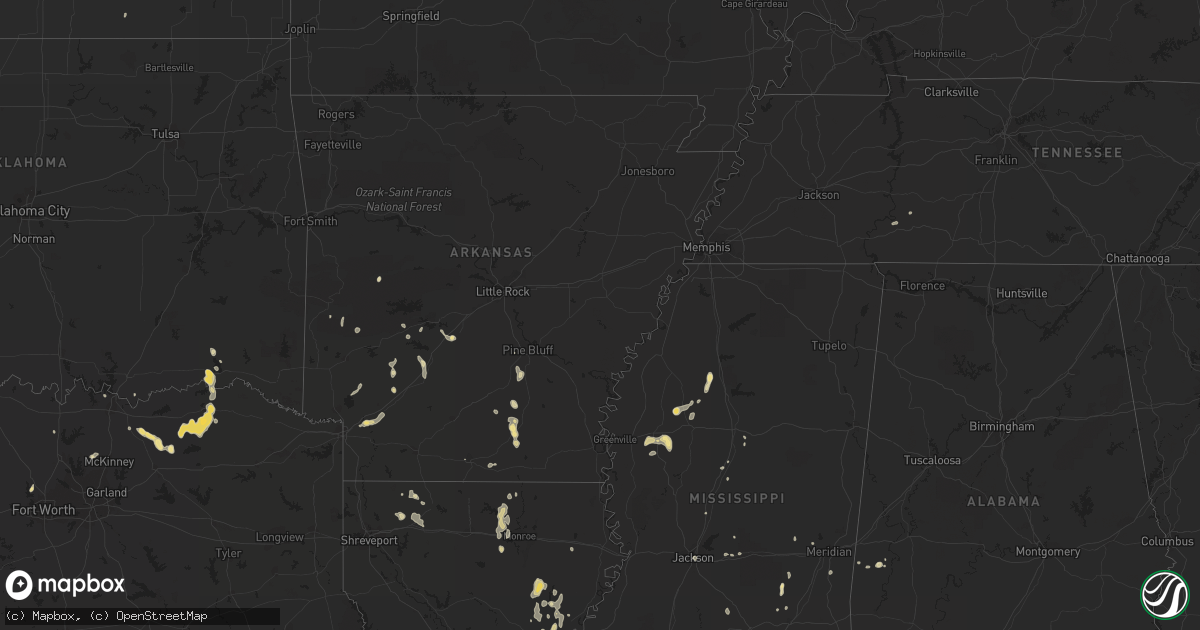
Hail Map in Mississippi on August 6, 2012
Get this storm
August 6 map
$229
one time, instant access
Download today. No call, no setup
Keep the $229
Bought the map and want the full workflow? Apply the entire $229 to a subscription within 7 days. None of it is wasted.
Every map, not just this one
This buys you this map. Subscription and you get every map we run, in the markets you choose from a few cities to whole states to nationwide. Plus real-time alerts the moment a storm fires.
Contact data
Name, contact info, occupancy, even credit band for addresses in the footprint. You go from where it hit to who to call.
Become the source they trust
Unlimited branding weather history reports on demand. You already have the documented answer ready for the property owner, and you are the one who showed up with it.
Property data and RoofTrace estimates
Pull up any address you have got, its value and the exact code rules for that jurisdiction, straight from One Click Code. Then RoofTrace estimates the squares, pitch, and roof value, priced the way you price.
Storm reports in Mississippi
Mississippi
| Date | Description |
|---|---|
| 08/06/20125:00 PM CDT | Tree down on experiment station rd near gallman. |
| 08/06/20124:50 PM CDT | Trees down and power outages in crystal springs. |
| 08/06/20124:25 PM CDT | Trees down at bluemoon dr and camp dantzler rd. |
| 08/06/20124:20 PM CDT | Trees down in byram/lake ridgelea area. Tree on car on w ridge dr and another tree fell on a patio on rod st |
| 08/06/20124:05 PM CDT | Tree down at 711 w capitol st |
| 08/06/20124:00 PM CDT | Large tree down at eatonville rd and sibs hobson. |
| 08/06/20124:00 PM CDT | Tree down at wood st and peach orchard place. Another down at st ann and laurel st. |
| 08/06/20124:00 PM CDT | At a downtown jackson office building. |
| 08/06/20123:50 PM CDT | Large tree limbs across moselle-oak grove rd. |
| 08/06/20123:45 PM CDT | Three trees down. One tree fell on vehicle on augusta rd. Road is blocked. Unknown injuries. |
| 08/06/20123:35 PM CDT | Reports of multiple trees down and some trees on powerlines in east brandon and pelahatchie area. Trees were also down on walters road near highway 43. |
All States Impacted by Hail Map on August 6, 2012
Cities Impacted by Hail Map on August 6, 2012
- Sicily Island, LA
- Bassett, NE
- Jonesville, LA
- Harrisonburg, LA
- Ashton, NE
- Boelus, NE
- Farwell, NE
- Pottsboro, TX
- Denison, TX
- Independence, LA
- Loranger, LA
- Texarkana, AR
- Fulton, AR
- Hope, AR
- Taylor, NE
- Gibbon, NE
- Warren, AR
- Hermitage, AR
- Hendrix, OK
- Wolfe City, TX
- Stapleton, NE
- Arnold, NE
- Brooksville, FL
- Winter Garden, FL
- Arkadelphia, AR
- Biloxi, MS
- Sulphur, LA
- Schlater, MS
- Malvern, AR
- Amite, LA
- Greensburg, LA
- Callaway, NE
- Gothenburg, NE
- Mena, AR
- Commerce, TX
- Minden, NE
- Winnsboro, LA
- Columbia, LA
- Fort Necessity, LA
- North Platte, NE
- Tryon, NE
- Singer, LA
- Baton Rouge, LA
- Lucas, KS
- Isola, MS
- Hugo, OK
- Buna, TX
- Oconto, NE
- Long Pine, NE
- Calhoun, LA
- Bluffton, AR
- Woodworth, LA
- Farmerville, LA
- Downsville, LA
- Minden, LA
- Moorhead, MS
- Inverness, MS
- Rison, AR
- Itta Bena, MS
- Indianola, MS
- Belzoni, MS
- Delight, AR
- Ellisville, MS
- Prosper, TX
- Orange, TX
- Ferriday, LA
- Clayton, LA
- Saratoga, TX
- West Monroe, LA
- New Edinburg, AR
- Lucedale, MS
- Meadville, MS
- Bonham, TX
- Whitewright, TX
- Randolph, TX
- Trenton, TX
- Leonard, TX
- Bailey, TX
- Fort Worth, TX
- Hampton, AR
- Delhi, LA
- Eros, LA
- Halsey, NE
- Paris, TX
- Powderly, TX
- Arthur City, TX
- Elton, LA
- Bay Springs, MS
- Louin, MS
- Denham Springs, LA
- Tampa, FL
- Pecan Gap, TX
- Cooper, TX
- Ben Franklin, TX
- Roxton, TX
- Ladonia, TX
- Wisner, LA
- Moselle, MS
- Jacksboro, TX
- Scobey, MS
- Tillatoba, MS
- Cascilla, MS
- Overton, NE
- Loomis, NE
- Shelton, NE
- Meridian, MS
- Quitman, MS
- Wesley Chapel, FL
- Marion, LA
- Osborne, KS
- Sallis, MS
- Pelahatchie, MS
- Brandon, MS
- Morse, LA
- Jennings, LA
- Mermentau, LA
- Bonnerdale, AR
- Shongaloo, LA
- Haynesville, LA
- Dequincy, LA
- Clermont, FL
- Enterprise, LA
- Lisman, AL
- Foley, AL
- Pattonville, TX
- Lake Creek, TX
- Brookston, TX
- Mineral Springs, AR
- Nashville, AR
- Campbell, NE
- Saucier, MS
- Pearcy, AR
- Hot Springs National Park, AR
- Charleston, MS
- Oakland, MS
- Holcomb, MS
- Grant, OK
- Morton, MS
- Prescott, AR
- Purvis, MS
- El Dorado, AR
- Strong, AR
- Forest Hill, LA
- Kirbyville, TX
- Beaumont, TX
- Bladen, NE
- Gravelly, AR
- Magee, MS
- Mount Olive, MS
- Gurdon, AR
- Kilmichael, MS
- Butler, AL
- Jachin, AL
- Hilliard, FL
- Rattan, OK
- Fairhope, AL
- Lumberton, TX
- Dannebrog, NE
- Antlers, OK
- Lumberton, MS
- Waynesboro, TN
- Clifton, TN
- Minter City, MS
- Philipp, MS
- Doddsville, MS
- Greenwood, MS
- Baker, LA
- Zachary, LA
- Canton, MS
- Cape Coral, FL
- Orleans, NE
- Valley View, TX
- Era, TX
- Hattiesburg, MS
- Pennington, AL
- Ward, AL
- Bismarck, AR
- Amity, AR
- Vinton, LA
- Red Cloud, NE
- Vidor, TX
- Laurel, MS
- Sour Lake, TX
- Cottonwood Falls, KS
- Poplarville, MS
- Winona, MS
- Decatur, MS
- West, MS
- Cotton Valley, LA
- Elm Creek, NE
- Bertrand, NE
- Holdrege, NE
- Kountze, TX
- Durant, MS
- Ellsworth, KS
- Homer, LA
- Celina, TX
- Mckinney, TX
- Kearney, NE
- Port Allen, LA
- Stringer, MS
- Sylvan Grove, KS
- Cedar Vale, KS
- Jackson, MS
- Flowood, MS
- Heartwell, NE
- Franklinton, LA
- Pine Bluff, AR
- Caddo Gap, AR
- Atlanta, NE
- Chunky, MS
- Collinsville, MS
- New London, NC
- Haughton, LA
- Jacksonville, FL
- Sawyer, OK
- Spencerville, OK


