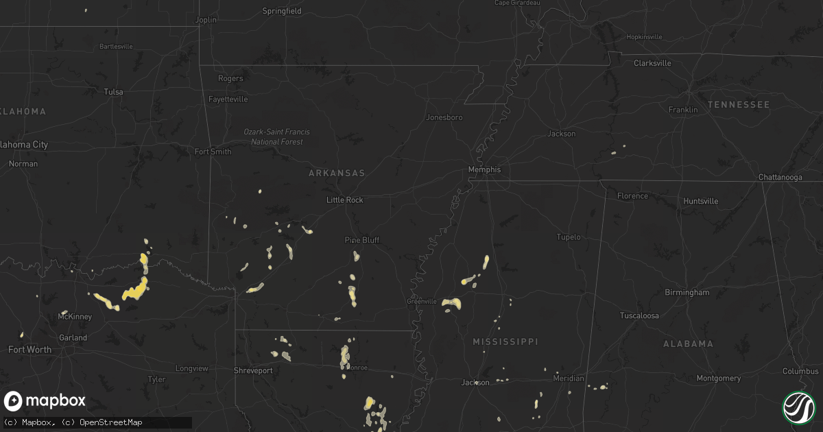
Hail Map in Louisiana on August 6, 2012
Get this storm
August 6 map
$229
one time, instant access
Download today. No call, no setup
Keep the $229
Bought the map and want the full workflow? Apply the entire $229 to a subscription within 7 days. None of it is wasted.
Every map, not just this one
This buys you this map. Subscription and you get every map we run, in the markets you choose from a few cities to whole states to nationwide. Plus real-time alerts the moment a storm fires.
Contact data
Name, contact info, occupancy, even credit band for addresses in the footprint. You go from where it hit to who to call.
Become the source they trust
Unlimited branding weather history reports on demand. You already have the documented answer ready for the property owner, and you are the one who showed up with it.
Property data and RoofTrace estimates
Pull up any address you have got, its value and the exact code rules for that jurisdiction, straight from One Click Code. Then RoofTrace estimates the squares, pitch, and roof value, priced the way you price.
Storm reports in Louisiana
Louisiana
| Date | Description |
|---|---|
| 08/06/20126:20 PM CDT | Tree down chadwick area west monroe |
| 08/06/20125:55 PM CDT | Trees and power lines down |
| 08/06/20125:50 PM CDT | Power lines down on deloutre switch road |
| 08/06/20124:00 PM CDT | Trees down on dorcheat road |
| 08/06/20123:30 PM CDT | A large tree limb was blown into a passing vehicle traveling highway 9...shattering the windshield. The motorist was not injured. |
| 08/06/20123:30 PM CDT | Trees down near shongaloo |
| 08/05/20128:10 PM CDT | Scattered trees down southwest of town causing power outages and road blockages. Winds estimated by emergency manager to be 50 mph. |
All States Impacted by Hail Map on August 6, 2012
Cities Impacted by Hail Map on August 6, 2012
- Sicily Island, LA
- Bassett, NE
- Jonesville, LA
- Harrisonburg, LA
- Ashton, NE
- Boelus, NE
- Farwell, NE
- Pottsboro, TX
- Denison, TX
- Independence, LA
- Loranger, LA
- Texarkana, AR
- Fulton, AR
- Hope, AR
- Taylor, NE
- Gibbon, NE
- Warren, AR
- Hermitage, AR
- Hendrix, OK
- Wolfe City, TX
- Stapleton, NE
- Arnold, NE
- Brooksville, FL
- Winter Garden, FL
- Arkadelphia, AR
- Biloxi, MS
- Sulphur, LA
- Schlater, MS
- Malvern, AR
- Amite, LA
- Greensburg, LA
- Callaway, NE
- Gothenburg, NE
- Mena, AR
- Commerce, TX
- Minden, NE
- Winnsboro, LA
- Columbia, LA
- Fort Necessity, LA
- North Platte, NE
- Tryon, NE
- Singer, LA
- Baton Rouge, LA
- Lucas, KS
- Isola, MS
- Hugo, OK
- Buna, TX
- Oconto, NE
- Long Pine, NE
- Calhoun, LA
- Bluffton, AR
- Woodworth, LA
- Farmerville, LA
- Downsville, LA
- Minden, LA
- Moorhead, MS
- Inverness, MS
- Rison, AR
- Itta Bena, MS
- Indianola, MS
- Belzoni, MS
- Delight, AR
- Ellisville, MS
- Prosper, TX
- Orange, TX
- Ferriday, LA
- Clayton, LA
- Saratoga, TX
- West Monroe, LA
- New Edinburg, AR
- Lucedale, MS
- Meadville, MS
- Bonham, TX
- Whitewright, TX
- Randolph, TX
- Trenton, TX
- Leonard, TX
- Bailey, TX
- Fort Worth, TX
- Hampton, AR
- Delhi, LA
- Eros, LA
- Halsey, NE
- Paris, TX
- Powderly, TX
- Arthur City, TX
- Elton, LA
- Bay Springs, MS
- Louin, MS
- Denham Springs, LA
- Tampa, FL
- Pecan Gap, TX
- Cooper, TX
- Ben Franklin, TX
- Roxton, TX
- Ladonia, TX
- Wisner, LA
- Moselle, MS
- Jacksboro, TX
- Scobey, MS
- Tillatoba, MS
- Cascilla, MS
- Overton, NE
- Loomis, NE
- Shelton, NE
- Meridian, MS
- Quitman, MS
- Wesley Chapel, FL
- Marion, LA
- Osborne, KS
- Sallis, MS
- Pelahatchie, MS
- Brandon, MS
- Morse, LA
- Jennings, LA
- Mermentau, LA
- Bonnerdale, AR
- Shongaloo, LA
- Haynesville, LA
- Dequincy, LA
- Clermont, FL
- Enterprise, LA
- Lisman, AL
- Foley, AL
- Pattonville, TX
- Lake Creek, TX
- Brookston, TX
- Mineral Springs, AR
- Nashville, AR
- Campbell, NE
- Saucier, MS
- Pearcy, AR
- Hot Springs National Park, AR
- Charleston, MS
- Oakland, MS
- Holcomb, MS
- Grant, OK
- Morton, MS
- Prescott, AR
- Purvis, MS
- El Dorado, AR
- Strong, AR
- Forest Hill, LA
- Kirbyville, TX
- Beaumont, TX
- Bladen, NE
- Gravelly, AR
- Magee, MS
- Mount Olive, MS
- Gurdon, AR
- Kilmichael, MS
- Butler, AL
- Jachin, AL
- Hilliard, FL
- Rattan, OK
- Fairhope, AL
- Lumberton, TX
- Dannebrog, NE
- Antlers, OK
- Lumberton, MS
- Waynesboro, TN
- Clifton, TN
- Minter City, MS
- Philipp, MS
- Doddsville, MS
- Greenwood, MS
- Baker, LA
- Zachary, LA
- Canton, MS
- Cape Coral, FL
- Orleans, NE
- Valley View, TX
- Era, TX
- Hattiesburg, MS
- Pennington, AL
- Ward, AL
- Bismarck, AR
- Amity, AR
- Vinton, LA
- Red Cloud, NE
- Vidor, TX
- Laurel, MS
- Sour Lake, TX
- Cottonwood Falls, KS
- Poplarville, MS
- Winona, MS
- Decatur, MS
- West, MS
- Cotton Valley, LA
- Elm Creek, NE
- Bertrand, NE
- Holdrege, NE
- Kountze, TX
- Durant, MS
- Ellsworth, KS
- Homer, LA
- Celina, TX
- Mckinney, TX
- Kearney, NE
- Port Allen, LA
- Stringer, MS
- Sylvan Grove, KS
- Cedar Vale, KS
- Jackson, MS
- Flowood, MS
- Heartwell, NE
- Franklinton, LA
- Pine Bluff, AR
- Caddo Gap, AR
- Atlanta, NE
- Chunky, MS
- Collinsville, MS
- New London, NC
- Haughton, LA
- Jacksonville, FL
- Sawyer, OK
- Spencerville, OK


