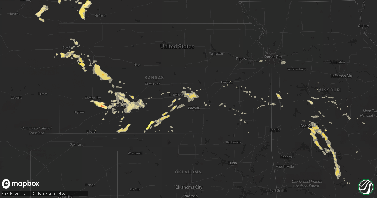
Hail Map in Montana on August 5, 2013
Get this storm
August 5 map
$229
one time, instant access
Download today. No call, no setup
Keep the $229
Bought the map and want the full workflow? Apply the entire $229 to a subscription within 7 days. None of it is wasted.
Every map, not just this one
This buys you this map. Subscription and you get every map we run, in the markets you choose from a few cities to whole states to nationwide. Plus real-time alerts the moment a storm fires.
Contact data
Name, contact info, occupancy, even credit band for addresses in the footprint. You go from where it hit to who to call.
Become the source they trust
Unlimited branding weather history reports on demand. You already have the documented answer ready for the property owner, and you are the one who showed up with it.
Property data and RoofTrace estimates
Pull up any address you have got, its value and the exact code rules for that jurisdiction, straight from One Click Code. Then RoofTrace estimates the squares, pitch, and roof value, priced the way you price.
Storm reports in Montana
Montana
| Date | Description |
|---|---|
| 08/05/20136:40 PM CDT | A local report indicates 1.00 inch wind near 17 NE VOLBORG |
| 08/05/20136:35 PM CDT | Part of a roof on a home torn off. |
| 08/05/20136:30 PM CDT | Power poles north of their property were knocked down. Power was out for several hours. |
| 08/05/20136:15 PM CDT | Some 5 inch limbs down on chain link fence. Minor tree damage around town. |
| 08/05/20136:03 PM CDT | Sustained wind at 44 mph |
| 08/05/20135:50 PM CDT | A local report indicates 1.00 inch wind near 7 SE BAYLOR |
| 08/05/20135:30 PM CDT | Hail lasted for 2 minutes. Ended at 430 pm. |
| 08/05/20135:30 PM CDT | 68 mph thunderstorm wind gust a few miles north of galata. Time of event is estimated. |
| 08/05/20135:00 PM CDT | Quarter-sized hail around 4 pm mdt. Crop damage reported. |
| 08/05/20135:00 PM CDT | Received delayed report from trained spotter of quarter-size hail from storm on aug 5 at 400 pm approx. 25 miles nw of ft benton |
| 08/05/20135:00 PM CDT | Winds estimated to at least 60 mph. Several tree branches down. Peas size hail and .75 rainfall. |
| 08/05/20134:57 PM CDT | Possible microburst from a collapsing storm. |
| 08/05/20134:35 PM CDT | Golf ball sized hail. Crop damage. |
| 08/05/20134:28 PM CDT | Nickel to quarter size hail. 50 mph winds. |
| 08/05/20134:25 PM CDT | Quarter sized hail covering the ground. |
| 08/05/20134:05 PM CDT | A local report indicates 1.25 inch wind near 25 NE DODSON |
| 08/05/20134:02 PM CDT | Hail ranging from pea to quarter sized. |
| 08/05/20133:40 PM CDT | A local report indicates 1.00 inch wind near 11 S DEVON |
| 08/05/20132:40 PM CDT | Quarter sized hail reported near the glacier wind farm. |
| 08/04/20138:15 PM CDT | A local report indicates 1.00 inch wind near 9 NW ALBION |
| 08/04/20138:15 PM CDT | A local report indicates 1.75 inch wind near 2 NNE ALBION |
| 08/04/20138:15 PM CDT | Broken windows in house. |
| 08/04/20138:00 PM CDT | Hen egg hail stripped siding and screens from house. |
| 08/04/20138:00 PM CDT | A local report indicates 65 MPH wind near 7 S RIDGEWAY |
| 08/04/20137:55 PM CDT | A local report indicates 1.75 inch wind near 11 WSW CAPITOL |
| 08/04/20137:55 PM CDT | A local report indicates 75 MPH wind near 11 WSW CAPITOL |
| 08/04/20137:40 PM CDT | Measured at cannonball creek raws |
| 08/04/20137:39 PM CDT | Power flickering on and off. |
| 08/04/20137:27 PM CDT | Hail and wind destroyed over 600 acres of crop and 1200-1500 acres of grass for their cattle. A window was broken on the house. |
| 08/04/20137:15 PM CDT | A local report indicates 60 MPH wind near 2 SSW PLEVNA |
All States Impacted by Hail Map on August 5, 2013
Cities Impacted by Hail Map on August 5, 2013
- Isabel, KS
- Medicine Lodge, KS
- Nashville, KS
- Spivey, KS
- Zenda, KS
- Wellfleet, NE
- North Platte, NE
- Isabella, MO
- Thornfield, MO
- Rogersville, MO
- Bruner, MO
- Fordland, MO
- Belle Fourche, SD
- Poplar, MT
- Hammond, MT
- Alzada, MT
- Ozark, MO
- Sparta, MO
- Springfield, MO
- Maxwell, NE
- Gillette, WY
- Pierson, FL
- White River, SD
- Inverness, MT
- Yuma, CO
- Otis, CO
- Scotland, SD
- Lesterville, SD
- Jacksonville, AR
- Cabot, AR
- Kadoka, SD
- Interior, SD
- Wanblee, SD
- Fredonia, KS
- Benedict, KS
- Arlington, NE
- Eudora, AR
- Wolf Point, MT
- Burlington, CO
- Hayes Center, NE
- Palisade, NE
- Chester, MT
- Winona, KS
- Havre, MT
- Saint Paul, NE
- Wolbach, NE
- Fort Benton, MT
- Goodland, KS
- Sharon Springs, KS
- Kanorado, KS
- Weskan, KS
- Hershey, NE
- Brewster, KS
- Edson, KS
- Brockton, MT
- Douglas, AZ
- Eureka, MT
- Columbia Falls, MT
- Roach, MO
- Camdenton, MO
- Frazer, MT
- Volborg, MT
- Neodesha, KS
- Independence, KS
- Peabody, KS
- Walton, KS
- Fort Pierre, SD
- Gunnison, MS
- Tucumcari, NM
- Drasco, AR
- Ida, AR
- Tumbling Shoals, AR
- Port Orange, FL
- Twin City, GA
- Kenmare, ND
- Bowbells, ND
- Flaxton, ND
- Vida, MT
- Circle, MT
- Licking, MO
- Roby, MO
- Success, MO
- Wauneta, NE
- Offerle, KS
- Spearville, KS
- Greensburg, KS
- Bucklin, KS
- Kinsley, KS
- Diberville, MS
- Biloxi, MS
- Keystone, SD
- Custer, SD
- Hermosa, SD
- Hill City, SD
- Dodge City, KS
- Ensign, KS
- Cheney, KS
- Haven, KS
- Stafford, KS
- Shelby, MT
- Kevin, MT
- Cut Bank, MT
- Clearmont, WY
- Shawnee, KS
- Preston, MO
- Macks Creek, MO
- Cross Timbers, MO
- Brockway, MT
- Fremont, NE
- Winifred, MT
- Outlook, MT
- Rapid City, SD
- Pontiac, MO
- Saco, MT
- Hinsdale, MT
- Malta, MT
- Glasgow, MT
- Norfork, AR
- Mountain View, AR
- Mountain Home, AR
- Marshall, AR
- Strafford, MO
- Garrison, MO
- Gainesville, MO
- Rueter, MO
- Midway, AR
- Chadwick, MO
- Big Flat, AR
- Brookline, MO
- Oldfield, MO
- Cedarcreek, MO
- Gassville, AR
- Highlandville, MO
- Harriet, AR
- Kissee Mills, MO
- Fifty Six, AR
- Ava, MO
- Leslie, AR
- Calico Rock, AR
- Nixa, MO
- Onia, AR
- Taneyville, MO
- Forsyth, MO
- Fox, AR
- Oakland, AR
- Seymour, MO
- Shirley, AR
- Noble, MO
- Wasola, MO
- Timbo, AR
- Squires, MO
- Protem, MO
- Meadow Grove, NE
- Madison, NE
- Newport, NE
- Stuart, NE
- Tripp, SD
- Lewis, KS
- Ames, NE
- Nevada, MO
- Nobleton, FL
- Bushnell, FL
- Palmer, NE
- Archer, NE
- Nashua, MT
- Garden City, KS
- Yankton, SD
- Burrton, KS
- Sedgwick, KS
- Halstead, KS
- North Newton, KS
- Newton, KS
- Jetmore, KS
- Capitol, MT
- Buffalo, SD
- Newell, SD
- Hingham, MT
- Rudyard, MT
- Gildford, MT
- Lloyd, MT
- Big Sandy, MT
- Stoutland, MO
- Richland, MO
- Belden, NE
- La Harpe, KS
- Estancia, NM
- Saint Francis, SD
- Benkelman, NE
- Stratton, NE
- Loring, MT
- Sheridan, WY
- Decker, MT
- Fairview, MT
- Sidney, MT
- Conrad, MT
- Wallace, KS
- Jefferson, SD
- North Sioux City, SD
- Burlington, KS
- Dixon, MO
- Crocker, MO
- Bay Springs, MS
- Montezuma, KS
- Ingalls, KS
- Rich Hill, MO
- Callaway, NE
- Gothenburg, NE
- Kingman, KS
- Cunningham, KS
- Amherst, CO
- Faith, SD
- Dighton, KS
- Whitewater, KS
- Bentley, KS
- Buhler, KS
- Moundridge, KS
- Hesston, KS
- Reva, SD
- Astor, FL
- Lyons, GA
- Swainsboro, GA
- Edgemont, AR
- Central City, NE
- Belgrade, NE
- Fullerton, NE
- Sutherland, NE
- Hutchinson, KS
- Richey, MT
- Springfield, SD
- Loma, MT
- Ash Grove, MO
- Walnut Grove, MO
- Willard, MO
- Lodge Grass, MT
- Brady, MT
- Valentine, NE
- Fort Scott, KS
- Healy, KS
- Pretty Prairie, KS
- Powell, WY
- Lambert, MT
- Uvalda, GA
- Coldwater, KS
- Moran, KS
- Norris, SD
- Parmelee, SD
- Milesville, SD
- Plains, KS
- Ledger, MT
- Lake City, KS
- Peerless, MT
- Champion, NE
- Holyoke, CO
- Cimarron, KS
- Pierceville, KS
- Kyle, SD
- Porcupine, SD
- Wright, KS
- Ponderosa, NM
- Redfield, KS
- Gate, OK
- Blackshear, GA
- Bancroft, NE
- Pender, NE
- Hermitage, MO
- Pittsburg, MO
- Houston, MO
- Winter Park, FL
- Minneola, KS
- Olpe, KS
- Kiowa, KS
- Hartington, NE
- Fordyce, NE
- Kinsey, MT
- Terry, MT
- De Witt, AR
- Gillett, AR
- Meade, KS
- Brady, NE
- Royal, NE
- Clearwater, NE
- Orchard, NE
- Ewing, NE
- Page, NE
- Pickens, MS
- Vaughan, MS
- Sterling, KS
- Soso, MS
- Inman, KS
- Mcpherson, KS
- Caputa, SD
- Long Valley, SD
- Imperial, NE
- Emporia, KS
- Owanka, SD
- New Underwood, SD
- Linwood, KS
- Eudora, KS
- De Soto, KS
- Bonner Springs, KS
- Ashland, KS
- Colony, KS
- Mud Butte, SD
- Winnett, MT
- Copeland, KS
- Stover, MO
- Wall, SD
- Partridge, KS
- Wewahitchka, FL
- Hathaway, MT
- Rosebud, MT
- Utica, SD
- Scribner, NE
- North Bend, NE
- Theodosia, MO
- Peel, AR
- Rozet, WY
- Macksville, KS
- Grinnell, KS
- Scott City, KS
- Beeler, KS
- Crookston, NE
- Tolley, ND
- Vidalia, GA
- Englewood, KS
- Vancleave, MS
- Fairburn, SD
- Clermont, FL
- Oakley, KS
- Cohagen, MT
- Wayne, NE
- Springer, NM
- Dakota City, NE
- Jackson, NE
- Hubbard, NE
- Tillatoba, MS
- Oakland, MS
- Winner, SD
- Culbertson, MT
- Nickerson, NE
- Rogers, NE
- Cedar Bluffs, NE
- Clarkson, NE
- Dodge, NE
- Howells, NE
- Hooper, NE
- Anthony, KS
- Monument, KS
- Thayer, KS
- Altoona, KS
- Eureka, KS
- Severy, KS
- Ponca, NE
- Colome, SD
- Springview, NE
- Ingomar, MT
- Fall River, KS
- Fulton, KS
- Gove, KS
- Larslan, MT
- Waldron, KS
- Hazlehurst, GA
- Dickens, NE
- Westphalia, KS
- Le Roy, KS
- Kalispell, MT
- Coram, MT
- Mission, SD
- Duncan, MS
- Newman Grove, NE
- Haviland, KS
- Byers, KS
- Coffeyville, KS
- Collins, MO
- Benoit, MS
- Ness City, KS
- Coffeeville, MS
- Raymond, MT
- Plentywood, MT
- Genoa, NE
- Dunnellon, FL
- Scobey, MT
- Grass Range, MT
- Roundup, MT
- Ruleville, MS
- Merigold, MS
- Cleveland, MS
- Hardtner, KS
- Hepler, KS
- Uniontown, KS
- Hanston, KS
- Orlando, FL
- Lebanon, MO
- Alma, GA
- Half Way, MO
- Urbana, MO
- Ord, NE
- Seville, FL
- Fort McCoy, FL
- Long Lane, MO
- Phillipsburg, MO
- Conway, MO
- Neligh, NE
- Macon, MS
- Newburg, MO
- Edgar Springs, MO
- Oakdale, NE
- Tilden, NE
- Big Creek, MS
- Protection, KS
- Winnebago, NE
- Emerson, NE
- Mammoth Spring, AR
- Avon, SD
- Edgemont, SD
- Venango, NE
- Lake Panasoffkee, FL
- Ocoee, FL
- Waterbury, NE
- Colby, KS
- Wood, SD
- Elkland, MO
- Bird City, KS
- Saint Marie, MT
- Ocean Springs, MS
- Upton, WY
- Dodson, MT
- Petersburg, NE
- Boyes, MT
- Ekalaka, MT
- El Dorado, KS
- Towanda, KS
- Bassett, NE
- Atkinson, NE
- Moorcroft, WY
- Liberal, KS
- Tarrytown, GA
- Ailey, GA
- Saint Francis, KS
- Geneva, FL
- Moss Point, MS
- Musselshell, MT
- Galva, KS
- Linn Creek, MO
- Beemer, NE
- Wisner, NE
- West Point, NE
- Leon, KS
- Moore Haven, FL
- Citronelle, AL
- Burlington, OK
- Enid, MS
- Pope, MS
- Richards, MO
- Walker, MO
- Brunswick, NE
- Montreal, MO
- Climax Springs, MO
- St John, KS
- Hartville, MO
- Mills, NE
- Hume, MO
- Humphrey, NE
- Brooksville, FL
- Floral City, FL
- Shelby, MS
- Haxtun, CO
- Wray, CO
- Waynesville, MO
- Calhoun City, MS
- Scenic, SD
- Saint Joe, AR
- Elgin, NE
- Lindsay, NE
- Battle Creek, NE
- Yellville, AR
- Laquey, MO
- Oak Hill, FL
- Raton, NM
- Snow Lake, AR
- Ford, KS
- Deerfield, MO
- Milo, MO
- Volin, SD
- Mission Hill, SD
- Sylvia, KS
- Lone Jack, MO
- Oak Grove, MO
- Grain Valley, MO
- Blue Springs, MO
- Greenwood, MO
- Lees Summit, MO
- Midland, SD
- Stark, KS
- Cuba, AL
- Lisman, AL
- Thurston, NE
- Salem, MO
- Fair Grove, MO
- Lothair, MT
- Cherryvale, KS
- Eldridge, MO
- Daytona Beach, FL
- Valley Park, MS
- Eminence, MO
- Longwood, FL
- Altamonte Springs, FL
- Waverly, KS
- Drew, MS
- Alligator, MS
- Clarksdale, MS
- Rockville, MO
- Pleasant Hope, MO
- Buffalo, MO
- Marshfield, MO
- Mullinville, KS
- Belpre, KS
- Attica, KS
- Dupree, SD
- Camp Crook, SD
- Prim, AR
- Presho, SD
- Ideal, SD
- Murdock, KS
- Andale, KS
- Garden Plain, KS
- Mount Hope, KS
- Bronaugh, MO
- Moundville, MO
- Laurel, NE
- Niangua, MO
- Lovell, WY
- Edwards, MO
- Morton, MS
- Arlington, KS
- Wheatland, MO
- Carroll, NE
- Randolph, NE
- Richland, MT


