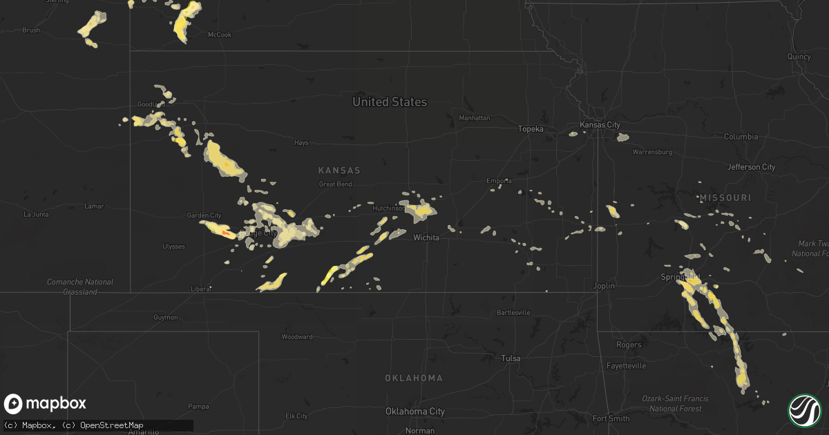
Hail Map in Kansas on August 5, 2013
Get this storm
August 5 map
$229
one time, instant access
Download today. No call, no setup
Keep the $229
Bought the map and want the full workflow? Apply the entire $229 to a subscription within 7 days. None of it is wasted.
Every map, not just this one
This buys you this map. Subscription and you get every map we run, in the markets you choose from a few cities to whole states to nationwide. Plus real-time alerts the moment a storm fires.
Contact data
Name, contact info, occupancy, even credit band for addresses in the footprint. You go from where it hit to who to call.
Become the source they trust
Unlimited branding weather history reports on demand. You already have the documented answer ready for the property owner, and you are the one who showed up with it.
Property data and RoofTrace estimates
Pull up any address you have got, its value and the exact code rules for that jurisdiction, straight from One Click Code. Then RoofTrace estimates the squares, pitch, and roof value, priced the way you price.
Storm reports in Kansas
Kansas
| Date | Description |
|---|---|
| 08/05/20136:45 PM CDT | A local report indicates 1.00 inch wind near 7 NNE AETNA |
| 08/05/20136:45 PM CDT | A local report indicates 60 MPH wind near 1 N ACRES |
| 08/05/20136:23 PM CDT | A local report indicates 60 MPH wind near SW NESS CITY |
| 08/05/20135:59 PM CDT | Also had 4-5 inch branches broken on his trees. |
| 08/05/20135:18 PM CDT | Also pea sized hail...very heavy rain...and visibilities less than a quarter of a mile. |
| 08/05/20135:10 PM CDT | Several 4 inch tree branches broken...some 6 to 8 inch tree branches broke. Also semi blown off of road |
| 08/05/20135:07 PM CDT | Also pea sized hail and small tree damage |
| 08/05/20134:57 PM CDT | A local report indicates 60 MPH wind near 3 N HEALY |
| 08/05/20134:35 PM CDT | A local report indicates 60 MPH wind near 5 E SCOTT STATE LAKE |
| 08/05/20133:54 PM CDT | Heavy rainfall and gusty winds were observed. Some small branches were blown to the ground. |
| 08/05/20133:20 PM CDT | Heavy rainfall observed. |
| 08/05/20133:11 PM CDT | A local report indicates 1.00 inch wind near 15 SW EDSON |
| 08/05/20131:40 PM CDT | Weak landspout tornado ne of the office. |
| 08/05/20131:35 PM CDT | Landspout seen from weather office to the northeast. Dissipated then one more formed a few minutes later. |
| 08/05/20131:28 PM CDT | Landspout seen from weather office to the northeast. Dissipated after about 2 minutes. |
| 08/05/20131:30 AM CDT | Large limbs blown down in devon along with 1.96 inches of rainfall in about an hour |
| 08/05/201312:10 AM CDT | A local report indicates 80 MPH wind near 9 SSE MOLINE |
| 08/05/201312:09 AM CDT | A local report indicates 60 MPH wind near FREDONIA |
| 08/04/201311:58 PM CDT | Numerous trees downed across the roads in the county. |
| 08/04/201311:38 PM CDT | Law enforcement estimated 70-75mph wind gusts at eureka lake. |
| 08/04/201311:29 PM CDT | Trees down on a house and a car. |
| 08/04/201311:13 PM CDT | Emergency manager reports 30 inch diameter tree uprooted at the country club and a few of similar size could be found uprooted in town as well. |
| 08/04/201310:52 PM CDT | A local report indicates 75 MPH wind near 1 N AUGUSTA |
| 08/04/201310:46 PM CDT | 10 inch diameter tree down |
| 08/04/201310:46 PM CDT | Trained spotter reported winds of 60 mph with very heavy rainfall |
| 08/04/201310:42 PM CDT | Measured 61 mph gust at el dorado high school |
| 08/04/201310:35 PM CDT | Report of a camper overturned at campground with no reports of injuries. Time estimated from radar |
| 08/04/201310:35 PM CDT | A local report indicates 70 MPH wind near 7 N BENTON |
| 08/04/201310:30 PM CDT | Reports of docks tossed around and flipped over at the shady creek marina. Time estimated from radar. |
| 08/04/201310:26 PM CDT | A local report indicates 67 MPH wind near 1 WSW WHITEWATER |
| 08/04/201310:25 PM CDT | Spotter estimated 50 to 60 mph winds with torrential rainfall |
| 08/04/201310:20 PM CDT | Delayed report of an estimated 65 mph winds with tree branches down as the storm moved through whitewater. |
| 08/04/201310:13 PM CDT | A local report indicates 65 MPH wind near ELBING |
| 08/04/201310:11 PM CDT | Estimated 70 to 80 mph on the southwest side of newton |
| 08/04/201310:06 PM CDT | Delayed report from the newton airport |
| 08/04/20139:41 PM CDT | Spotter estimated 50 to 60 mph winds |
| 08/04/20139:10 PM CDT | A local report indicates 70 MPH wind near CUNNINGHAM |
| 08/04/20139:09 PM CDT | A local report indicates 80 MPH wind near 8 E PRATT |
| 08/04/20139:08 PM CDT | 12 inch diameter trees reported down at nw 10th street and 70th ave. |
| 08/04/20139:00 PM CDT | A local report indicates 83 MPH wind near 3 E PRATT |
| 08/04/20138:52 PM CDT | Can hear limbs cracking in the background |
| 08/04/20138:50 PM CDT | Numerous powerlines down in and around pratt. The entire city of pratt was without power as well as cullison and iuka. Numerous trees were also reported down from culli |
| 08/04/20138:35 PM CDT | This was an estimated wind speed from a spotter that was reporting to the emergency manager. Damage from this high of wind speed was not yet reported in. |
| 08/04/20138:10 PM CDT | A local report indicates 1.75 inch wind near 5 S INGALLS |
| 08/04/20138:08 PM CDT | A local report indicates 2.75 inch wind near 7 S CHARLESTON |
| 08/04/20138:05 PM CDT | A local report indicates 1.75 inch wind near 9 S CHARLESTON |
| 08/04/20138:05 PM CDT | A local report indicates 60 MPH wind near 2 NNE CENTERVIEW |
| 08/04/20137:58 PM CDT | Spotter reported that their power was out and estimated winds of 50 mph along with very heavy rainfall. |
| 08/04/20137:46 PM CDT | A local report indicates 60 MPH wind near 2 SSE WILLOWDALE |
| 08/04/20137:30 PM CDT | A local report indicates 1.00 inch wind near 5 ENE PLYMELL |
| 08/04/20137:10 PM CDT | A local report indicates 60 MPH wind near 4 ESE JETMORE |
| 08/04/20137:07 PM CDT | A local report indicates 60 MPH wind near MEDICINE LODGE |
All States Impacted by Hail Map on August 5, 2013
Cities Impacted by Hail Map on August 5, 2013
- Isabel, KS
- Medicine Lodge, KS
- Nashville, KS
- Spivey, KS
- Zenda, KS
- Wellfleet, NE
- North Platte, NE
- Isabella, MO
- Thornfield, MO
- Rogersville, MO
- Bruner, MO
- Fordland, MO
- Belle Fourche, SD
- Poplar, MT
- Hammond, MT
- Alzada, MT
- Ozark, MO
- Sparta, MO
- Springfield, MO
- Maxwell, NE
- Gillette, WY
- Pierson, FL
- White River, SD
- Inverness, MT
- Yuma, CO
- Otis, CO
- Scotland, SD
- Lesterville, SD
- Jacksonville, AR
- Cabot, AR
- Kadoka, SD
- Interior, SD
- Wanblee, SD
- Fredonia, KS
- Benedict, KS
- Arlington, NE
- Eudora, AR
- Wolf Point, MT
- Burlington, CO
- Hayes Center, NE
- Palisade, NE
- Chester, MT
- Winona, KS
- Havre, MT
- Saint Paul, NE
- Wolbach, NE
- Fort Benton, MT
- Goodland, KS
- Sharon Springs, KS
- Kanorado, KS
- Weskan, KS
- Hershey, NE
- Brewster, KS
- Edson, KS
- Brockton, MT
- Douglas, AZ
- Eureka, MT
- Columbia Falls, MT
- Roach, MO
- Camdenton, MO
- Frazer, MT
- Volborg, MT
- Neodesha, KS
- Independence, KS
- Peabody, KS
- Walton, KS
- Fort Pierre, SD
- Gunnison, MS
- Tucumcari, NM
- Drasco, AR
- Ida, AR
- Tumbling Shoals, AR
- Port Orange, FL
- Twin City, GA
- Kenmare, ND
- Bowbells, ND
- Flaxton, ND
- Vida, MT
- Circle, MT
- Licking, MO
- Roby, MO
- Success, MO
- Wauneta, NE
- Offerle, KS
- Spearville, KS
- Greensburg, KS
- Bucklin, KS
- Kinsley, KS
- Diberville, MS
- Biloxi, MS
- Keystone, SD
- Custer, SD
- Hermosa, SD
- Hill City, SD
- Dodge City, KS
- Ensign, KS
- Cheney, KS
- Haven, KS
- Stafford, KS
- Shelby, MT
- Kevin, MT
- Cut Bank, MT
- Clearmont, WY
- Shawnee, KS
- Preston, MO
- Macks Creek, MO
- Cross Timbers, MO
- Brockway, MT
- Fremont, NE
- Winifred, MT
- Outlook, MT
- Rapid City, SD
- Pontiac, MO
- Saco, MT
- Hinsdale, MT
- Malta, MT
- Glasgow, MT
- Norfork, AR
- Mountain View, AR
- Mountain Home, AR
- Marshall, AR
- Strafford, MO
- Garrison, MO
- Gainesville, MO
- Rueter, MO
- Midway, AR
- Chadwick, MO
- Big Flat, AR
- Brookline, MO
- Oldfield, MO
- Cedarcreek, MO
- Gassville, AR
- Highlandville, MO
- Harriet, AR
- Kissee Mills, MO
- Fifty Six, AR
- Ava, MO
- Leslie, AR
- Calico Rock, AR
- Nixa, MO
- Onia, AR
- Taneyville, MO
- Forsyth, MO
- Fox, AR
- Oakland, AR
- Seymour, MO
- Shirley, AR
- Noble, MO
- Wasola, MO
- Timbo, AR
- Squires, MO
- Protem, MO
- Meadow Grove, NE
- Madison, NE
- Newport, NE
- Stuart, NE
- Tripp, SD
- Lewis, KS
- Ames, NE
- Nevada, MO
- Nobleton, FL
- Bushnell, FL
- Palmer, NE
- Archer, NE
- Nashua, MT
- Garden City, KS
- Yankton, SD
- Burrton, KS
- Sedgwick, KS
- Halstead, KS
- North Newton, KS
- Newton, KS
- Jetmore, KS
- Capitol, MT
- Buffalo, SD
- Newell, SD
- Hingham, MT
- Rudyard, MT
- Gildford, MT
- Lloyd, MT
- Big Sandy, MT
- Stoutland, MO
- Richland, MO
- Belden, NE
- La Harpe, KS
- Estancia, NM
- Saint Francis, SD
- Benkelman, NE
- Stratton, NE
- Loring, MT
- Sheridan, WY
- Decker, MT
- Fairview, MT
- Sidney, MT
- Conrad, MT
- Wallace, KS
- Jefferson, SD
- North Sioux City, SD
- Burlington, KS
- Dixon, MO
- Crocker, MO
- Bay Springs, MS
- Montezuma, KS
- Ingalls, KS
- Rich Hill, MO
- Callaway, NE
- Gothenburg, NE
- Kingman, KS
- Cunningham, KS
- Amherst, CO
- Faith, SD
- Dighton, KS
- Whitewater, KS
- Bentley, KS
- Buhler, KS
- Moundridge, KS
- Hesston, KS
- Reva, SD
- Astor, FL
- Lyons, GA
- Swainsboro, GA
- Edgemont, AR
- Central City, NE
- Belgrade, NE
- Fullerton, NE
- Sutherland, NE
- Hutchinson, KS
- Richey, MT
- Springfield, SD
- Loma, MT
- Ash Grove, MO
- Walnut Grove, MO
- Willard, MO
- Lodge Grass, MT
- Brady, MT
- Valentine, NE
- Fort Scott, KS
- Healy, KS
- Pretty Prairie, KS
- Powell, WY
- Lambert, MT
- Uvalda, GA
- Coldwater, KS
- Moran, KS
- Norris, SD
- Parmelee, SD
- Milesville, SD
- Plains, KS
- Ledger, MT
- Lake City, KS
- Peerless, MT
- Champion, NE
- Holyoke, CO
- Cimarron, KS
- Pierceville, KS
- Kyle, SD
- Porcupine, SD
- Wright, KS
- Ponderosa, NM
- Redfield, KS
- Gate, OK
- Blackshear, GA
- Bancroft, NE
- Pender, NE
- Hermitage, MO
- Pittsburg, MO
- Houston, MO
- Winter Park, FL
- Minneola, KS
- Olpe, KS
- Kiowa, KS
- Hartington, NE
- Fordyce, NE
- Kinsey, MT
- Terry, MT
- De Witt, AR
- Gillett, AR
- Meade, KS
- Brady, NE
- Royal, NE
- Clearwater, NE
- Orchard, NE
- Ewing, NE
- Page, NE
- Pickens, MS
- Vaughan, MS
- Sterling, KS
- Soso, MS
- Inman, KS
- Mcpherson, KS
- Caputa, SD
- Long Valley, SD
- Imperial, NE
- Emporia, KS
- Owanka, SD
- New Underwood, SD
- Linwood, KS
- Eudora, KS
- De Soto, KS
- Bonner Springs, KS
- Ashland, KS
- Colony, KS
- Mud Butte, SD
- Winnett, MT
- Copeland, KS
- Stover, MO
- Wall, SD
- Partridge, KS
- Wewahitchka, FL
- Hathaway, MT
- Rosebud, MT
- Utica, SD
- Scribner, NE
- North Bend, NE
- Theodosia, MO
- Peel, AR
- Rozet, WY
- Macksville, KS
- Grinnell, KS
- Scott City, KS
- Beeler, KS
- Crookston, NE
- Tolley, ND
- Vidalia, GA
- Englewood, KS
- Vancleave, MS
- Fairburn, SD
- Clermont, FL
- Oakley, KS
- Cohagen, MT
- Wayne, NE
- Springer, NM
- Dakota City, NE
- Jackson, NE
- Hubbard, NE
- Tillatoba, MS
- Oakland, MS
- Winner, SD
- Culbertson, MT
- Nickerson, NE
- Rogers, NE
- Cedar Bluffs, NE
- Clarkson, NE
- Dodge, NE
- Howells, NE
- Hooper, NE
- Anthony, KS
- Monument, KS
- Thayer, KS
- Altoona, KS
- Eureka, KS
- Severy, KS
- Ponca, NE
- Colome, SD
- Springview, NE
- Ingomar, MT
- Fall River, KS
- Fulton, KS
- Gove, KS
- Larslan, MT
- Waldron, KS
- Hazlehurst, GA
- Dickens, NE
- Westphalia, KS
- Le Roy, KS
- Kalispell, MT
- Coram, MT
- Mission, SD
- Duncan, MS
- Newman Grove, NE
- Haviland, KS
- Byers, KS
- Coffeyville, KS
- Collins, MO
- Benoit, MS
- Ness City, KS
- Coffeeville, MS
- Raymond, MT
- Plentywood, MT
- Genoa, NE
- Dunnellon, FL
- Scobey, MT
- Grass Range, MT
- Roundup, MT
- Ruleville, MS
- Merigold, MS
- Cleveland, MS
- Hardtner, KS
- Hepler, KS
- Uniontown, KS
- Hanston, KS
- Orlando, FL
- Lebanon, MO
- Alma, GA
- Half Way, MO
- Urbana, MO
- Ord, NE
- Seville, FL
- Fort McCoy, FL
- Long Lane, MO
- Phillipsburg, MO
- Conway, MO
- Neligh, NE
- Macon, MS
- Newburg, MO
- Edgar Springs, MO
- Oakdale, NE
- Tilden, NE
- Big Creek, MS
- Protection, KS
- Winnebago, NE
- Emerson, NE
- Mammoth Spring, AR
- Avon, SD
- Edgemont, SD
- Venango, NE
- Lake Panasoffkee, FL
- Ocoee, FL
- Waterbury, NE
- Colby, KS
- Wood, SD
- Elkland, MO
- Bird City, KS
- Saint Marie, MT
- Ocean Springs, MS
- Upton, WY
- Dodson, MT
- Petersburg, NE
- Boyes, MT
- Ekalaka, MT
- El Dorado, KS
- Towanda, KS
- Bassett, NE
- Atkinson, NE
- Moorcroft, WY
- Liberal, KS
- Tarrytown, GA
- Ailey, GA
- Saint Francis, KS
- Geneva, FL
- Moss Point, MS
- Musselshell, MT
- Galva, KS
- Linn Creek, MO
- Beemer, NE
- Wisner, NE
- West Point, NE
- Leon, KS
- Moore Haven, FL
- Citronelle, AL
- Burlington, OK
- Enid, MS
- Pope, MS
- Richards, MO
- Walker, MO
- Brunswick, NE
- Montreal, MO
- Climax Springs, MO
- St John, KS
- Hartville, MO
- Mills, NE
- Hume, MO
- Humphrey, NE
- Brooksville, FL
- Floral City, FL
- Shelby, MS
- Haxtun, CO
- Wray, CO
- Waynesville, MO
- Calhoun City, MS
- Scenic, SD
- Saint Joe, AR
- Elgin, NE
- Lindsay, NE
- Battle Creek, NE
- Yellville, AR
- Laquey, MO
- Oak Hill, FL
- Raton, NM
- Snow Lake, AR
- Ford, KS
- Deerfield, MO
- Milo, MO
- Volin, SD
- Mission Hill, SD
- Sylvia, KS
- Lone Jack, MO
- Oak Grove, MO
- Grain Valley, MO
- Blue Springs, MO
- Greenwood, MO
- Lees Summit, MO
- Midland, SD
- Stark, KS
- Cuba, AL
- Lisman, AL
- Thurston, NE
- Salem, MO
- Fair Grove, MO
- Lothair, MT
- Cherryvale, KS
- Eldridge, MO
- Daytona Beach, FL
- Valley Park, MS
- Eminence, MO
- Longwood, FL
- Altamonte Springs, FL
- Waverly, KS
- Drew, MS
- Alligator, MS
- Clarksdale, MS
- Rockville, MO
- Pleasant Hope, MO
- Buffalo, MO
- Marshfield, MO
- Mullinville, KS
- Belpre, KS
- Attica, KS
- Dupree, SD
- Camp Crook, SD
- Prim, AR
- Presho, SD
- Ideal, SD
- Murdock, KS
- Andale, KS
- Garden Plain, KS
- Mount Hope, KS
- Bronaugh, MO
- Moundville, MO
- Laurel, NE
- Niangua, MO
- Lovell, WY
- Edwards, MO
- Morton, MS
- Arlington, KS
- Wheatland, MO
- Carroll, NE
- Randolph, NE
- Richland, MT


