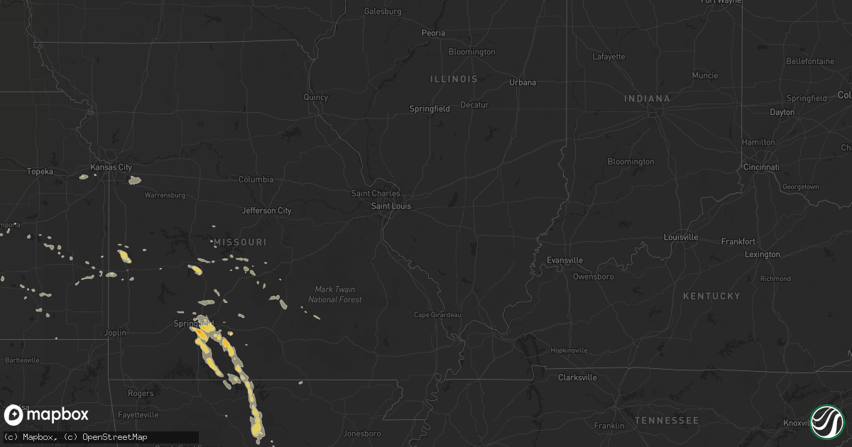
Hail Map on August 5, 2013
Get this storm
August 5 map
$229
one time, instant access
Download today. No call, no setup
Keep the $229
Bought the map and want the full workflow? Apply the entire $229 to a subscription within 7 days. None of it is wasted.
Every map, not just this one
This buys you this map. Subscription and you get every map we run, in the markets you choose from a few cities to whole states to nationwide. Plus real-time alerts the moment a storm fires.
Contact data
Name, contact info, occupancy, even credit band for addresses in the footprint. You go from where it hit to who to call.
Become the source they trust
Unlimited branding weather history reports on demand. You already have the documented answer ready for the property owner, and you are the one who showed up with it.
Property data and RoofTrace estimates
Pull up any address you have got, its value and the exact code rules for that jurisdiction, straight from One Click Code. Then RoofTrace estimates the squares, pitch, and roof value, priced the way you price.
States Impacted by Hail Map on August 5, 2013
Storm reports
Colorado
| Date | Description |
|---|---|
| 08/04/20138:30 PM CDT | A local report indicates 1.75 inch wind near 11 N YUMA |
Missouri
| Date | Description |
|---|---|
| 08/05/20136:56 PM CDT | Mostly dime sized hail with an occasional quarter size. |
| 08/05/20136:55 PM CDT | A local report indicates 1.75 inch wind near 4 NW AVA |
| 08/05/20136:55 PM CDT | A local report indicates 1.00 inch wind near 3 S ROGERSVILLE |
| 08/05/20133:15 AM CDT | Large tree limbs down. Delayed report. |
| 08/05/20132:00 AM CDT | Large tree branch over the road near the intersection of main street and ewing street. |
| 08/05/20132:00 AM CDT | Tree uprooted and power pole broken. Time estimated. |
| 08/04/20138:50 PM CDT | Trees and power lines reported down in and around protem. |
| 08/04/20138:39 PM CDT | Trees reported down. |
| 08/04/20138:34 PM CDT | Numerous trees down at 160 in rueter. |
| 08/04/20138:16 PM CDT | A local report indicates 1.25 inch wind near 2 NE KISSEE MILLS |
| 08/04/20138:07 PM CDT | Several large trees and powerlines down between forsyth and taneyville. |
| 08/04/20138:02 PM CDT | Trees reported down in theodosia. Roof damaged directly across the lake to the east of theodosia. Trees reported down in isabela also. |
| 08/04/20137:55 PM CDT | Trees down between theodosia and isabella on highway 160. |
| 08/04/20137:44 PM CDT | Numerous trees and power poles were down. Some locations were without power. |
| 08/04/20137:11 PM CDT | Multiple trees down and minor roof damage reported. |
| 08/04/20137:04 PM CDT | Delayed report from monday evening. |
| 08/04/20137:04 PM CDT | Delayed report from monday evening. |
Utah
| Date | Description |
|---|---|
| 08/05/20132:45 PM CDT | Near the intersection of utah state route 111 and new bingham highway...rocky mountain power reports an estimated 37 transmission poles and 23 distribution poles were k |
Idaho
| Date | Description |
|---|---|
| 08/05/20135:20 PM CDT | Dale bitner raws. Time of event estimated coincident with weak radar echoes moving through the area. Wind gust occurred sometime between 1546 and 1645 mdt. |
| 08/05/20135:19 PM CDT | Semi-truck blown off road near downey. Report time approximate and coincident with weak cell passing through area on radar. Neaby mesonet wind gust to 32 mph at malad s |
| 08/05/20134:48 PM CDT | Weakened trees downed and a power line downed. Time approxiamte and coincident with weak radar returns near lava hot springs. |
Florida
| Date | Description |
|---|---|
| 08/05/20131:35 PM CDT | A large tree was uprooted in the cove subdivision near goldenrod. Broadcast media also relayed images of several large broken tree limbs and damaged pool enclosures. Re |
North Dakota
| Date | Description |
|---|---|
| 08/04/20138:30 PM CDT | 7 n and 3 e of scranton. 60 mph winds. |
Iowa
| Date | Description |
|---|---|
| 08/05/20138:00 AM CDT | Small twigs and branches off of trees. Estimated 45 mph winds with occasional higher gusts. Heavy downpours reducing visibility to a few blocks in distance. |
Arkansas
| Date | Description |
|---|---|
| 08/04/201310:03 PM CDT | Trees down along hwy 66 west. |
| 08/04/20139:53 PM CDT | Trees down along hwy 5 north. |
| 08/04/20138:45 PM CDT | A local report indicates 1.00 inch wind near MOUNTAIN HOME |
| 08/04/20138:31 PM CDT | Tree fell an a car and trees down in the area. |
| 08/04/20138:28 PM CDT | Trees reported down. |
Kansas
| Date | Description |
|---|---|
| 08/05/20136:45 PM CDT | A local report indicates 60 MPH wind near 1 N ACRES |
| 08/05/20136:45 PM CDT | A local report indicates 1.00 inch wind near 7 NNE AETNA |
| 08/05/20136:23 PM CDT | A local report indicates 60 MPH wind near SW NESS CITY |
| 08/05/20135:59 PM CDT | Also had 4-5 inch branches broken on his trees. |
| 08/05/20135:18 PM CDT | Also pea sized hail...very heavy rain...and visibilities less than a quarter of a mile. |
| 08/05/20135:10 PM CDT | Several 4 inch tree branches broken...some 6 to 8 inch tree branches broke. Also semi blown off of road |
| 08/05/20135:07 PM CDT | Also pea sized hail and small tree damage |
| 08/05/20134:57 PM CDT | A local report indicates 60 MPH wind near 3 N HEALY |
| 08/05/20134:35 PM CDT | A local report indicates 60 MPH wind near 5 E SCOTT STATE LAKE |
| 08/05/20133:54 PM CDT | Heavy rainfall and gusty winds were observed. Some small branches were blown to the ground. |
| 08/05/20133:20 PM CDT | Heavy rainfall observed. |
| 08/05/20133:11 PM CDT | A local report indicates 1.00 inch wind near 15 SW EDSON |
| 08/05/20131:40 PM CDT | Weak landspout tornado ne of the office. |
| 08/05/20131:35 PM CDT | Landspout seen from weather office to the northeast. Dissipated then one more formed a few minutes later. |
| 08/05/20131:28 PM CDT | Landspout seen from weather office to the northeast. Dissipated after about 2 minutes. |
| 08/05/20131:30 AM CDT | Large limbs blown down in devon along with 1.96 inches of rainfall in about an hour |
| 08/05/201312:10 AM CDT | A local report indicates 80 MPH wind near 9 SSE MOLINE |
| 08/05/201312:09 AM CDT | A local report indicates 60 MPH wind near FREDONIA |
| 08/04/201311:58 PM CDT | Numerous trees downed across the roads in the county. |
| 08/04/201311:38 PM CDT | Law enforcement estimated 70-75mph wind gusts at eureka lake. |
| 08/04/201311:29 PM CDT | Trees down on a house and a car. |
| 08/04/201311:13 PM CDT | Emergency manager reports 30 inch diameter tree uprooted at the country club and a few of similar size could be found uprooted in town as well. |
| 08/04/201310:52 PM CDT | A local report indicates 75 MPH wind near 1 N AUGUSTA |
| 08/04/201310:46 PM CDT | 10 inch diameter tree down |
| 08/04/201310:46 PM CDT | Trained spotter reported winds of 60 mph with very heavy rainfall |
| 08/04/201310:42 PM CDT | Measured 61 mph gust at el dorado high school |
| 08/04/201310:35 PM CDT | Report of a camper overturned at campground with no reports of injuries. Time estimated from radar |
| 08/04/201310:35 PM CDT | A local report indicates 70 MPH wind near 7 N BENTON |
| 08/04/201310:30 PM CDT | Reports of docks tossed around and flipped over at the shady creek marina. Time estimated from radar. |
| 08/04/201310:26 PM CDT | A local report indicates 67 MPH wind near 1 WSW WHITEWATER |
| 08/04/201310:25 PM CDT | Spotter estimated 50 to 60 mph winds with torrential rainfall |
| 08/04/201310:20 PM CDT | Delayed report of an estimated 65 mph winds with tree branches down as the storm moved through whitewater. |
| 08/04/201310:13 PM CDT | A local report indicates 65 MPH wind near ELBING |
| 08/04/201310:11 PM CDT | Estimated 70 to 80 mph on the southwest side of newton |
| 08/04/201310:06 PM CDT | Delayed report from the newton airport |
| 08/04/20139:41 PM CDT | Spotter estimated 50 to 60 mph winds |
| 08/04/20139:10 PM CDT | A local report indicates 70 MPH wind near CUNNINGHAM |
| 08/04/20139:09 PM CDT | A local report indicates 80 MPH wind near 8 E PRATT |
| 08/04/20139:08 PM CDT | 12 inch diameter trees reported down at nw 10th street and 70th ave. |
| 08/04/20139:00 PM CDT | A local report indicates 83 MPH wind near 3 E PRATT |
| 08/04/20138:52 PM CDT | Can hear limbs cracking in the background |
| 08/04/20138:50 PM CDT | Numerous powerlines down in and around pratt. The entire city of pratt was without power as well as cullison and iuka. Numerous trees were also reported down from culli |
| 08/04/20138:35 PM CDT | This was an estimated wind speed from a spotter that was reporting to the emergency manager. Damage from this high of wind speed was not yet reported in. |
| 08/04/20138:10 PM CDT | A local report indicates 1.75 inch wind near 5 S INGALLS |
| 08/04/20138:08 PM CDT | A local report indicates 2.75 inch wind near 7 S CHARLESTON |
| 08/04/20138:05 PM CDT | A local report indicates 60 MPH wind near 2 NNE CENTERVIEW |
| 08/04/20138:05 PM CDT | A local report indicates 1.75 inch wind near 9 S CHARLESTON |
| 08/04/20137:58 PM CDT | Spotter reported that their power was out and estimated winds of 50 mph along with very heavy rainfall. |
| 08/04/20137:46 PM CDT | A local report indicates 60 MPH wind near 2 SSE WILLOWDALE |
| 08/04/20137:30 PM CDT | A local report indicates 1.00 inch wind near 5 ENE PLYMELL |
| 08/04/20137:10 PM CDT | A local report indicates 60 MPH wind near 4 ESE JETMORE |
| 08/04/20137:07 PM CDT | A local report indicates 60 MPH wind near MEDICINE LODGE |
Nebraska
| Date | Description |
|---|---|
| 08/05/20136:55 PM CDT | A local report indicates 1.00 inch wind near 8 N WAUNETA |
| 08/05/20136:40 PM CDT | A local report indicates 1.00 inch wind near 9 SW HAYES CENTER |
| 08/05/20136:20 PM CDT | Corn field is damaged and the ground is white from the hail. |
| 08/05/20135:50 PM CDT | A local report indicates 1.00 inch wind near 4 N WELLFLEET |
| 08/04/20138:42 PM CDT | A local report indicates 62 MPH wind near 3 E NORTH PLATTE |
| 08/04/20138:38 PM CDT | Large branches were reported down across highway 30 just west of the airport. |
| 08/04/20138:30 PM CDT | A local report indicates 1.00 inch wind near STRATTON NE |
| 08/04/20138:05 PM CDT | A local report indicates 1.50 inch wind near 7 NNW STRATTON NE |
| 08/04/20137:37 PM CDT | A local report indicates 1.00 inch wind near 12 N STRATTON NE |
| 08/04/20137:25 PM CDT | A local report indicates 1.00 inch wind near 4 W HAMLET |
Georgia
| Date | Description |
|---|---|
| 08/05/20133:25 PM CDT | The public reported quarter sized hail between nunez and oak park. |
Mississippi
| Date | Description |
|---|---|
| 08/05/20134:45 PM CDT | Large trees down om power lines. Roof damge to shed. |
| 08/05/20134:30 PM CDT | Power lines reported down in the diberville area. |
South Dakota
| Date | Description |
|---|---|
| 08/05/20136:50 PM CDT | A local report indicates 1.75 inch wind near 5 NNE DOWNTOWN CUSTER |
| 08/05/20136:50 PM CDT | A local report indicates 1.00 inch wind near 4 S HILL CITY |
| 08/05/20133:55 AM CDT | A local report indicates 70 MPH wind near 1 ESE MISSION |
| 08/05/20133:00 AM CDT | A local report indicates 65 MPH wind near 11 ENE WANBLEE |
| 08/05/20132:20 AM CDT | A local report indicates 64 MPH wind near 4 E CACTUS FLAT |
| 08/05/201312:17 AM CDT | Flag ripped from flagpole and pole slightly bent |
| 08/04/201311:30 PM CDT | Cocorahs report of 60 mph winds at residence. |
| 08/04/201311:30 PM CDT | Also reported pea size hail with the winds |
| 08/04/201311:00 PM CDT | A local report indicates 60 MPH wind near 4 S MILESVILLE |
| 08/04/201310:50 PM CDT | A local report indicates 60 MPH wind near 5 NE MILESVILLE |
| 08/04/201310:30 PM CDT | A local report indicates 70 MPH wind near RED SCAFFOLD |
| 08/04/201310:26 PM CDT | A local report indicates 65 MPH wind near 11 WNW RED SCAFFOLD |
| 08/04/201310:20 PM CDT | A local report indicates 70 MPH wind near UNION CENTER |
| 08/04/201310:20 PM CDT | A local report indicates 60 MPH wind near 2 ENE WHITE OWL |
| 08/04/20139:50 PM CDT | A local report indicates 71 MPH wind near 1 NE MUD BUTTE |
| 08/04/20139:40 PM CDT | A local report indicates 60 MPH wind near 5 NNE MAURINE |
| 08/04/20139:35 PM CDT | A local report indicates 60 MPH wind near 11 ESE ZEONA |
| 08/04/20139:25 PM CDT | A local report indicates 60 MPH wind near HOOVER |
| 08/04/20139:15 PM CDT | A local report indicates 65 MPH wind near 8 NW ZEONA |
| 08/04/20139:09 PM CDT | A local report indicates 1.75 inch wind near 21 WSW CASTLE ROCK |
| 08/04/20138:57 PM CDT | A local report indicates 70 MPH wind near 15 ENE REDIG |
| 08/04/20138:45 PM CDT | A local report indicates 60 MPH wind near 10 SE BUFFALO |
| 08/04/20138:30 PM CDT | Dime-sized hail also |
| 08/04/20138:08 PM CDT | A local report indicates 75 MPH wind near 10 SW LADNER |
| 08/04/20137:20 PM CDT | A local report indicates 1.00 inch wind near 9 NW FAIRBURN |
| 08/04/20137:10 PM CDT | A local report indicates 1.00 inch wind near 9 ENE DOWNTOWN CUSTER |
Montana
| Date | Description |
|---|---|
| 08/05/20136:40 PM CDT | A local report indicates 1.00 inch wind near 17 NE VOLBORG |
| 08/05/20136:35 PM CDT | Part of a roof on a home torn off. |
| 08/05/20136:30 PM CDT | Power poles north of their property were knocked down. Power was out for several hours. |
| 08/05/20136:15 PM CDT | Some 5 inch limbs down on chain link fence. Minor tree damage around town. |
| 08/05/20136:03 PM CDT | Sustained wind at 44 mph |
| 08/05/20135:50 PM CDT | A local report indicates 1.00 inch wind near 7 SE BAYLOR |
| 08/05/20135:30 PM CDT | Hail lasted for 2 minutes. Ended at 430 pm. |
| 08/05/20135:30 PM CDT | 68 mph thunderstorm wind gust a few miles north of galata. Time of event is estimated. |
| 08/05/20135:00 PM CDT | Winds estimated to at least 60 mph. Several tree branches down. Peas size hail and .75 rainfall. |
| 08/05/20135:00 PM CDT | Quarter-sized hail around 4 pm mdt. Crop damage reported. |
| 08/05/20135:00 PM CDT | Received delayed report from trained spotter of quarter-size hail from storm on aug 5 at 400 pm approx. 25 miles nw of ft benton |
| 08/05/20134:57 PM CDT | Possible microburst from a collapsing storm. |
| 08/05/20134:35 PM CDT | Golf ball sized hail. Crop damage. |
| 08/05/20134:28 PM CDT | Nickel to quarter size hail. 50 mph winds. |
| 08/05/20134:25 PM CDT | Quarter sized hail covering the ground. |
| 08/05/20134:05 PM CDT | A local report indicates 1.25 inch wind near 25 NE DODSON |
| 08/05/20134:02 PM CDT | Hail ranging from pea to quarter sized. |
| 08/05/20133:40 PM CDT | A local report indicates 1.00 inch wind near 11 S DEVON |
| 08/05/20132:40 PM CDT | Quarter sized hail reported near the glacier wind farm. |
| 08/04/20138:15 PM CDT | Broken windows in house. |
| 08/04/20138:15 PM CDT | A local report indicates 1.75 inch wind near 2 NNE ALBION |
| 08/04/20138:15 PM CDT | A local report indicates 1.00 inch wind near 9 NW ALBION |
| 08/04/20138:00 PM CDT | A local report indicates 65 MPH wind near 7 S RIDGEWAY |
| 08/04/20138:00 PM CDT | Hen egg hail stripped siding and screens from house. |
| 08/04/20137:55 PM CDT | A local report indicates 75 MPH wind near 11 WSW CAPITOL |
| 08/04/20137:55 PM CDT | A local report indicates 1.75 inch wind near 11 WSW CAPITOL |
| 08/04/20137:40 PM CDT | Measured at cannonball creek raws |
| 08/04/20137:39 PM CDT | Power flickering on and off. |
| 08/04/20137:27 PM CDT | Hail and wind destroyed over 600 acres of crop and 1200-1500 acres of grass for their cattle. A window was broken on the house. |
| 08/04/20137:15 PM CDT | A local report indicates 60 MPH wind near 2 SSW PLEVNA |
Wyoming
| Date | Description |
|---|---|
| 08/05/20136:20 PM CDT | A local report indicates 1.00 inch wind near 3 SSE MOORCROFT |
| 08/05/20136:10 PM CDT | A local report indicates 1.00 inch wind near 3 SSE MOORCROFT |
| 08/05/20136:05 PM CDT | A local report indicates 1.00 inch wind near 3 SW UPTON |
| 08/05/20135:31 PM CDT | A local report indicates 1.00 inch wind near 5 NE DOWNTOWN GILLETTE |
| 08/05/20135:16 PM CDT | A local report indicates 1.00 inch wind near 5 WSW UPTON |
New Mexico
| Date | Description |
|---|---|
| 08/04/20137:00 PM CDT | Large pine tree blown over on garver lane. |
Cities Impacted by Hail Map on August 5, 2013
- Isabel, KS
- Medicine Lodge, KS
- Nashville, KS
- Spivey, KS
- Zenda, KS
- Wellfleet, NE
- North Platte, NE
- Isabella, MO
- Thornfield, MO
- Rogersville, MO
- Bruner, MO
- Fordland, MO
- Belle Fourche, SD
- Poplar, MT
- Hammond, MT
- Alzada, MT
- Ozark, MO
- Sparta, MO
- Springfield, MO
- Maxwell, NE
- Gillette, WY
- Pierson, FL
- White River, SD
- Inverness, MT
- Yuma, CO
- Otis, CO
- Scotland, SD
- Lesterville, SD
- Jacksonville, AR
- Cabot, AR
- Kadoka, SD
- Interior, SD
- Wanblee, SD
- Fredonia, KS
- Benedict, KS
- Arlington, NE
- Eudora, AR
- Wolf Point, MT
- Burlington, CO
- Hayes Center, NE
- Palisade, NE
- Chester, MT
- Winona, KS
- Havre, MT
- Saint Paul, NE
- Wolbach, NE
- Fort Benton, MT
- Goodland, KS
- Sharon Springs, KS
- Kanorado, KS
- Weskan, KS
- Hershey, NE
- Brewster, KS
- Edson, KS
- Brockton, MT
- Douglas, AZ
- Eureka, MT
- Columbia Falls, MT
- Roach, MO
- Camdenton, MO
- Frazer, MT
- Volborg, MT
- Neodesha, KS
- Independence, KS
- Peabody, KS
- Walton, KS
- Fort Pierre, SD
- Gunnison, MS
- Tucumcari, NM
- Drasco, AR
- Ida, AR
- Tumbling Shoals, AR
- Port Orange, FL
- Twin City, GA
- Kenmare, ND
- Bowbells, ND
- Flaxton, ND
- Vida, MT
- Circle, MT
- Licking, MO
- Roby, MO
- Success, MO
- Wauneta, NE
- Offerle, KS
- Spearville, KS
- Greensburg, KS
- Bucklin, KS
- Kinsley, KS
- Diberville, MS
- Biloxi, MS
- Keystone, SD
- Custer, SD
- Hermosa, SD
- Hill City, SD
- Dodge City, KS
- Ensign, KS
- Cheney, KS
- Haven, KS
- Stafford, KS
- Shelby, MT
- Kevin, MT
- Cut Bank, MT
- Clearmont, WY
- Shawnee, KS
- Preston, MO
- Macks Creek, MO
- Cross Timbers, MO
- Brockway, MT
- Fremont, NE
- Winifred, MT
- Outlook, MT
- Rapid City, SD
- Pontiac, MO
- Saco, MT
- Hinsdale, MT
- Malta, MT
- Glasgow, MT
- Norfork, AR
- Mountain View, AR
- Mountain Home, AR
- Marshall, AR
- Strafford, MO
- Garrison, MO
- Gainesville, MO
- Rueter, MO
- Midway, AR
- Chadwick, MO
- Big Flat, AR
- Brookline, MO
- Oldfield, MO
- Cedarcreek, MO
- Gassville, AR
- Highlandville, MO
- Harriet, AR
- Kissee Mills, MO
- Fifty Six, AR
- Ava, MO
- Leslie, AR
- Calico Rock, AR
- Nixa, MO
- Onia, AR
- Taneyville, MO
- Forsyth, MO
- Fox, AR
- Oakland, AR
- Seymour, MO
- Shirley, AR
- Noble, MO
- Wasola, MO
- Timbo, AR
- Squires, MO
- Protem, MO
- Meadow Grove, NE
- Madison, NE
- Newport, NE
- Stuart, NE
- Tripp, SD
- Lewis, KS
- Ames, NE
- Nevada, MO
- Nobleton, FL
- Bushnell, FL
- Palmer, NE
- Archer, NE
- Nashua, MT
- Garden City, KS
- Yankton, SD
- Burrton, KS
- Sedgwick, KS
- Halstead, KS
- North Newton, KS
- Newton, KS
- Jetmore, KS
- Capitol, MT
- Buffalo, SD
- Newell, SD
- Hingham, MT
- Rudyard, MT
- Gildford, MT
- Lloyd, MT
- Big Sandy, MT
- Stoutland, MO
- Richland, MO
- Belden, NE
- La Harpe, KS
- Estancia, NM
- Saint Francis, SD
- Benkelman, NE
- Stratton, NE
- Loring, MT
- Sheridan, WY
- Decker, MT
- Fairview, MT
- Sidney, MT
- Conrad, MT
- Wallace, KS
- Jefferson, SD
- North Sioux City, SD
- Burlington, KS
- Dixon, MO
- Crocker, MO
- Bay Springs, MS
- Montezuma, KS
- Ingalls, KS
- Rich Hill, MO
- Callaway, NE
- Gothenburg, NE
- Kingman, KS
- Cunningham, KS
- Amherst, CO
- Faith, SD
- Dighton, KS
- Whitewater, KS
- Bentley, KS
- Buhler, KS
- Moundridge, KS
- Hesston, KS
- Reva, SD
- Astor, FL
- Lyons, GA
- Swainsboro, GA
- Edgemont, AR
- Central City, NE
- Belgrade, NE
- Fullerton, NE
- Sutherland, NE
- Hutchinson, KS
- Richey, MT
- Springfield, SD
- Loma, MT
- Ash Grove, MO
- Walnut Grove, MO
- Willard, MO
- Lodge Grass, MT
- Brady, MT
- Valentine, NE
- Fort Scott, KS
- Healy, KS
- Pretty Prairie, KS
- Powell, WY
- Lambert, MT
- Uvalda, GA
- Coldwater, KS
- Moran, KS
- Norris, SD
- Parmelee, SD
- Milesville, SD
- Plains, KS
- Ledger, MT
- Lake City, KS
- Peerless, MT
- Champion, NE
- Holyoke, CO
- Cimarron, KS
- Pierceville, KS
- Kyle, SD
- Porcupine, SD
- Wright, KS
- Ponderosa, NM
- Redfield, KS
- Gate, OK
- Blackshear, GA
- Bancroft, NE
- Pender, NE
- Hermitage, MO
- Pittsburg, MO
- Houston, MO
- Winter Park, FL
- Minneola, KS
- Olpe, KS
- Kiowa, KS
- Hartington, NE
- Fordyce, NE
- Kinsey, MT
- Terry, MT
- De Witt, AR
- Gillett, AR
- Meade, KS
- Brady, NE
- Royal, NE
- Clearwater, NE
- Orchard, NE
- Ewing, NE
- Page, NE
- Pickens, MS
- Vaughan, MS
- Sterling, KS
- Soso, MS
- Inman, KS
- Mcpherson, KS
- Caputa, SD
- Long Valley, SD
- Imperial, NE
- Emporia, KS
- Owanka, SD
- New Underwood, SD
- Linwood, KS
- Eudora, KS
- De Soto, KS
- Bonner Springs, KS
- Ashland, KS
- Colony, KS
- Mud Butte, SD
- Winnett, MT
- Copeland, KS
- Stover, MO
- Wall, SD
- Partridge, KS
- Wewahitchka, FL
- Hathaway, MT
- Rosebud, MT
- Utica, SD
- Scribner, NE
- North Bend, NE
- Theodosia, MO
- Peel, AR
- Rozet, WY
- Macksville, KS
- Grinnell, KS
- Scott City, KS
- Beeler, KS
- Crookston, NE
- Tolley, ND
- Vidalia, GA
- Englewood, KS
- Vancleave, MS
- Fairburn, SD
- Clermont, FL
- Oakley, KS
- Cohagen, MT
- Wayne, NE
- Springer, NM
- Dakota City, NE
- Jackson, NE
- Hubbard, NE
- Tillatoba, MS
- Oakland, MS
- Winner, SD
- Culbertson, MT
- Nickerson, NE
- Rogers, NE
- Cedar Bluffs, NE
- Clarkson, NE
- Dodge, NE
- Howells, NE
- Hooper, NE
- Anthony, KS
- Monument, KS
- Thayer, KS
- Altoona, KS
- Eureka, KS
- Severy, KS
- Ponca, NE
- Colome, SD
- Springview, NE
- Ingomar, MT
- Fall River, KS
- Fulton, KS
- Gove, KS
- Larslan, MT
- Waldron, KS
- Hazlehurst, GA
- Dickens, NE
- Westphalia, KS
- Le Roy, KS
- Kalispell, MT
- Coram, MT
- Mission, SD
- Duncan, MS
- Newman Grove, NE
- Haviland, KS
- Byers, KS
- Coffeyville, KS
- Collins, MO
- Benoit, MS
- Ness City, KS
- Coffeeville, MS
- Raymond, MT
- Plentywood, MT
- Genoa, NE
- Dunnellon, FL
- Scobey, MT
- Grass Range, MT
- Roundup, MT
- Ruleville, MS
- Merigold, MS
- Cleveland, MS
- Hardtner, KS
- Hepler, KS
- Uniontown, KS
- Hanston, KS
- Orlando, FL
- Lebanon, MO
- Alma, GA
- Half Way, MO
- Urbana, MO
- Ord, NE
- Seville, FL
- Fort McCoy, FL
- Long Lane, MO
- Phillipsburg, MO
- Conway, MO
- Neligh, NE
- Macon, MS
- Newburg, MO
- Edgar Springs, MO
- Oakdale, NE
- Tilden, NE
- Big Creek, MS
- Protection, KS
- Winnebago, NE
- Emerson, NE
- Mammoth Spring, AR
- Avon, SD
- Edgemont, SD
- Venango, NE
- Lake Panasoffkee, FL
- Ocoee, FL
- Waterbury, NE
- Colby, KS
- Wood, SD
- Elkland, MO
- Bird City, KS
- Saint Marie, MT
- Ocean Springs, MS
- Upton, WY
- Dodson, MT
- Petersburg, NE
- Boyes, MT
- Ekalaka, MT
- El Dorado, KS
- Towanda, KS
- Bassett, NE
- Atkinson, NE
- Moorcroft, WY
- Liberal, KS
- Tarrytown, GA
- Ailey, GA
- Saint Francis, KS
- Geneva, FL
- Moss Point, MS
- Musselshell, MT
- Galva, KS
- Linn Creek, MO
- Beemer, NE
- Wisner, NE
- West Point, NE
- Leon, KS
- Moore Haven, FL
- Citronelle, AL
- Burlington, OK
- Enid, MS
- Pope, MS
- Richards, MO
- Walker, MO
- Brunswick, NE
- Montreal, MO
- Climax Springs, MO
- St John, KS
- Hartville, MO
- Mills, NE
- Hume, MO
- Humphrey, NE
- Brooksville, FL
- Floral City, FL
- Shelby, MS
- Haxtun, CO
- Wray, CO
- Waynesville, MO
- Calhoun City, MS
- Scenic, SD
- Saint Joe, AR
- Elgin, NE
- Lindsay, NE
- Battle Creek, NE
- Yellville, AR
- Laquey, MO
- Oak Hill, FL
- Raton, NM
- Snow Lake, AR
- Ford, KS
- Deerfield, MO
- Milo, MO
- Volin, SD
- Mission Hill, SD
- Sylvia, KS
- Lone Jack, MO
- Oak Grove, MO
- Grain Valley, MO
- Blue Springs, MO
- Greenwood, MO
- Lees Summit, MO
- Midland, SD
- Stark, KS
- Cuba, AL
- Lisman, AL
- Thurston, NE
- Salem, MO
- Fair Grove, MO
- Lothair, MT
- Cherryvale, KS
- Eldridge, MO
- Daytona Beach, FL
- Valley Park, MS
- Eminence, MO
- Longwood, FL
- Altamonte Springs, FL
- Waverly, KS
- Drew, MS
- Alligator, MS
- Clarksdale, MS
- Rockville, MO
- Pleasant Hope, MO
- Buffalo, MO
- Marshfield, MO
- Mullinville, KS
- Belpre, KS
- Attica, KS
- Dupree, SD
- Camp Crook, SD
- Prim, AR
- Presho, SD
- Ideal, SD
- Murdock, KS
- Andale, KS
- Garden Plain, KS
- Mount Hope, KS
- Bronaugh, MO
- Moundville, MO
- Laurel, NE
- Niangua, MO
- Lovell, WY
- Edwards, MO
- Morton, MS
- Arlington, KS
- Wheatland, MO
- Carroll, NE
- Randolph, NE
- Richland, MT