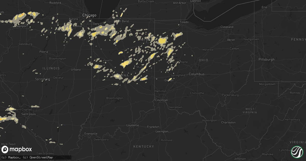
Hail Map in Indiana on August 4, 2012
Get this storm
August 4 map
$229
one time, instant access
Download today. No call, no setup
Keep the $229
Bought the map and want the full workflow? Apply the entire $229 to a subscription within 7 days. None of it is wasted.
Every map, not just this one
This buys you this map. Subscription and you get every map we run, in the markets you choose from a few cities to whole states to nationwide. Plus real-time alerts the moment a storm fires.
Contact data
Name, contact info, occupancy, even credit band for addresses in the footprint. You go from where it hit to who to call.
Become the source they trust
Unlimited branding weather history reports on demand. You already have the documented answer ready for the property owner, and you are the one who showed up with it.
Property data and RoofTrace estimates
Pull up any address you have got, its value and the exact code rules for that jurisdiction, straight from One Click Code. Then RoofTrace estimates the squares, pitch, and roof value, priced the way you price.
Storm reports in Indiana
Indiana
| Date | Description |
|---|---|
| 08/04/20126:57 PM CDT | A local report indicates 65 MPH wind near JONESBORO |
| 08/04/20126:55 PM CDT | Along with winds in excess of 50 mph |
| 08/04/20126:52 PM CDT | Trees and power lines down on rangeline road and 500 n |
| 08/04/20126:50 PM CDT | Tree limbs downed and tree downed in roadway at county roads 400 north and 525 east. |
| 08/04/20126:50 PM CDT | 2 outbuildings damaged... One destroyed. Moderate damage to a home. |
| 08/04/20126:47 PM CDT | Large tree down on mckeever road. Time estimated from radar. |
| 08/04/20126:45 PM CDT | Tree down near county road 115n and route 24. |
| 08/04/20126:20 PM CDT | Tree downed on a home in tipton. |
| 08/04/20126:13 PM CDT | Estimated 65 mph winds at national weather service office. |
| 08/04/20126:01 PM CDT | Numerous trees down in warsaw...winona lake....and across northern portions of the county |
| 08/04/20125:50 PM CDT | A small tree reported down. |
| 08/04/20125:50 PM CDT | A local report indicates 65 MPH wind near 1 E ELKHART |
| 08/04/20125:48 PM CDT | Large branches down near county road 1. |
| 08/04/20125:43 PM CDT | Corn flattened. |
| 08/04/20125:38 PM CDT | Estimated 60 to 70 mph winds. Time estimated from radar. |
| 08/04/20125:38 PM CDT | A local report indicates 60 MPH wind near MISHAWAKA |
| 08/04/20125:35 PM CDT | Trees down throughout the county. Tree down across us31 south of 30. Lines down in culver which started a fire. |
| 08/04/20125:23 PM CDT | Intersection of rt 30 and burr. At 14 inch diameter tree which was 25 feet tall fell on house next to it. |
| 08/04/20125:20 PM CDT | Trees and power lines down. |
| 08/04/20125:10 PM CDT | 2 large trees down. |
| 08/04/20125:03 PM CDT | A local report indicates 66 MPH wind near 4 NW SOUTH BEND |
| 08/04/20124:58 PM CDT | A local report indicates 1.00 inch wind near OBER |
| 08/04/20124:57 PM CDT | Power lines down along us 421 near wanatah and hail slightly larger than quarters also reported. |
| 08/04/20124:57 PM CDT | Power lines down along us 421 near wanatah and hail slightly larger than quarters also reported. |
| 08/04/20124:53 PM CDT | A local report indicates 59 MPH wind near VALPARAISO |
| 08/04/20124:44 PM CDT | Ridge and cline |
| 08/04/20124:38 PM CDT | A local report indicates 1.00 inch wind near 2 E ALDINE |
| 08/04/20124:23 PM CDT | A local report indicates 61 MPH wind near GARY |
| 08/04/20122:05 PM CDT | One healty tree down across the road and partially onto a pick -up truck. Tree is about 50 feet tall and 16 to 18 inches in diameter. Location approx. |
| 08/04/20121:25 PM CDT | Measured at eagle creek asos. |
| 08/04/20126:00 AM CDT | Tree reported down on i-70 east near mm 153. Time estimated. |
| 08/04/20125:55 AM CDT | Tree down on college corner road near west grove road. Time estimated. |
| 08/04/20125:38 AM CDT | Tree down on plum street. Time estimated. |
| 08/04/20125:35 AM CDT | Trees downed near spiceland rd and cr400s. |
| 08/04/20124:45 AM CDT | Power outages in noblesville area. |
| 08/04/20124:45 AM CDT | Numerous trees down between 46th and 49th street and college and keystone. Much of the area also without power. |
| 08/04/20124:42 AM CDT | One tree down and another partially down. |
| 08/04/20124:15 AM CDT | Outbuilding damaged. |
| 08/04/20124:05 AM CDT | Large tree down blocking roadway. Time estimated from radar. Late report. |
| 08/03/20127:29 PM CDT | Large tree branches reported down. |
| 08/03/20127:29 PM CDT | Tree limbs and power lines down in portland and pennville |
| 08/03/20127:10 PM CDT | Large tree down across road near rockford. Large limbs down on 450 e and 100 n |
| 08/03/20127:10 PM CDT | Trees downed near kennard. |
| 08/03/20127:08 PM CDT | Large tree down near wayne street and 2nd. Time estimated from radar |
| 08/03/20127:02 PM CDT | A local report indicates 60 MPH wind near PARKER CITY |
| 08/03/20127:00 PM CDT | Measured at the intersection of maplecrest and interstate 469 |
| 08/03/20127:00 PM CDT | Estimated size of nickel to quarter |
| 08/03/20127:00 PM CDT | Maple tree snapped off eight feet above ground. Nearby trees also sustained tree limb damage. |
All States Impacted by Hail Map on August 4, 2012
Cities Impacted by Hail Map on August 4, 2012
- Rolla, MO
- Newburg, MO
- Geneva, IN
- Celina, OH
- Portland, IN
- Rockford, OH
- Berne, IN
- Bryant, IN
- Ponca City, OK
- Knox, IN
- Tipton, IN
- Long Lane, MO
- Conway, MO
- Elkland, MO
- Putnam, IL
- Morrison, IL
- Bryant, IA
- Sterling, IL
- Clinton, IA
- Fulton, IL
- Chadwick, IL
- Thomson, IL
- Charlotte, TN
- Danville, AL
- Moulton, AL
- Bay Springs, MS
- Louin, MS
- Dowagiac, MI
- Niles, MI
- Hudson, KY
- Big Clifty, KY
- Leslie, MO
- Chamois, MO
- Mount Sterling, MO
- Freeburg, MO
- Linn, MO
- Gerald, MO
- Owensville, MO
- New Haven, MO
- Hermann, MO
- Morrison, MO
- Bland, MO
- Rosebud, MO
- Belle, MO
- Milton, IN
- Falmouth, IN
- Hagerstown, IN
- Straughn, IN
- Mays, IN
- New Castle, IN
- Connersville, IN
- Cambridge City, IN
- Lewisville, IN
- Knightstown, IN
- Rushville, IN
- Edna, KS
- Troy, MO
- Foristell, MO
- Jasper, MO
- Harlan, IN
- Antwerp, OH
- New Haven, IN
- Woodburn, IN
- Bristol, FL
- Piqua, OH
- Troy, OH
- Fletcher, OH
- Bellefontaine, OH
- Decatur, IN
- Willshire, OH
- Uniondale, IN
- Ossian, IN
- Ohio City, OH
- Monroe, IN
- Bluffton, IN
- Continental, OH
- Paulding, OH
- Payne, OH
- Oakwood, OH
- Melrose, OH
- Convoy, OH
- Fort Jennings, OH
- Van Wert, OH
- Cloverdale, OH
- Scott, OH
- Delphos, OH
- Cecil, OH
- Venedocia, OH
- Defiance, OH
- Latty, OH
- Grover Hill, OH
- Haviland, OH
- Middle Point, OH
- Athens, IL
- Sparta, MO
- Spokane, MO
- Highlandville, MO
- Galena, MO
- Forsyth, MO
- Ponce De Leon, MO
- Ozark, MO
- Oldfield, MO
- Chadwick, MO
- Bruner, MO
- Baker, LA
- Zachary, LA
- Thayer, KS
- Goldsmith, IN
- Atlanta, IN
- Sharpsville, IN
- Oronogo, MO
- Lebanon, MO
- Ransom, IL
- Portage, OH
- Rudolph, OH
- Kendallville, IN
- Pittsburg, KS
- Weir, KS
- Asbury, MO
- Galena, KS
- Carl Junction, MO
- Nashua, NH
- Hillsdale, IN
- Saint Henry, OH
- Fenton, IL
- Erie, IL
- Stevensville, MI
- Grovespring, MO
- Niangua, MO
- Vienna, MO
- East Berlin, PA
- Dillsburg, PA
- Wellsville, PA
- Dover, PA
- Richland, MO
- Vine Grove, KY
- Craigville, IN
- Plainfield, MA
- Ashfield, MA
- Leroy, AL
- House, NM
- Mcalister, NM
- Fitchburg, MA
- Lunenburg, MA
- Leominster, MA
- Casstown, OH
- Saint Paris, OH
- Sidney, OH
- Conover, OH
- Garrison, IA
- Peru, IN
- Dayton, OH
- Chetopa, KS
- Eaton, OH
- Ottawa, IL
- Walnut Grove, MO
- New Boston, NH
- Carthage, MO
- Mound Valley, KS
- Royalston, MA
- Fort Sumner, NM
- Vinton, IA
- Royal Center, IN
- Sigourney, IA
- Arlington, IN
- West Brooklyn, IL
- Ashton, IL
- Dixon, MO
- Albion, IN
- Laotto, IN
- Churubusco, IN
- Avilla, IN
- Duke, MO
- La Russell, MO
- Stotts City, MO
- Alger, OH
- Ada, OH
- Harrod, OH
- Schneider, IN
- Lowell, IN
- Grant Park, IL
- Crown Point, IN
- Hebron, IN
- Yorkville, IL
- Newark, IL
- Afton, OK
- Fairland, OK
- Grove, OK
- Fortville, IN
- Pendleton, IN
- Ingalls, IN
- Gorham, IL
- Murphysboro, IL
- Reedsville, WI
- Greenleaf, WI
- Denmark, WI
- Maribel, WI
- Whitelaw, WI
- Rineyville, KY
- Elizabethtown, KY
- Rhineland, MO
- Portland, MO
- Birmingham, AL
- Louisa, KY
- Pontiac, IL
- Bremen, IN
- Findlay, OH
- Arlington, OH
- Mount Blanchard, OH
- Clarinda, IA
- New Market, IA
- Calamus, IA
- Poplar Bluff, MO
- Grandin, MO
- Doniphan, MO
- Cayuga, IN
- Drury, MA
- Anderson, IN
- Monroeville, IN
- Vichy, MO
- Remington, IN
- Wolcott, IN
- Granger, IA
- Dallas Center, IA
- Catoosa, OK
- Owasso, OK
- Poneto, IN
- Markle, IN
- Warren, IN
- Liberty Center, IN
- Lockwood, MO
- University Park, IL
- Park Forest, IL
- Steger, IL
- Crete, IL
- Walton, IN
- Galveston, IN
- Logansport, IN
- Lenapah, OK
- Delaware, OK
- Vinita, OK
- Valparaiso, IN
- Wanatah, IN
- Elmo, MO
- Westboro, MO
- Pierce City, MO
- Stark City, MO
- Walnut Shade, MO
- Reeds Spring, MO
- Chestnutridge, MO
- Townsend, MA
- West Townsend, MA
- Pawhuska, OK
- Arcadia, IN
- Windfall, IN
- Kempton, IN
- Elwood, IN
- Kokomo, IN
- Swayzee, IN
- Frankfort, IN
- Greentown, IN
- Cicero, IN
- Sheridan, IN
- Fairmount, IN
- Jonesboro, IN
- Ainsworth, IA
- Ash Grove, MO
- Everton, MO
- Wabash, IN
- Lima, OH
- Wapakoneta, OH
- Seymour, MO
- Hillsborough, NH
- Walnut, IL
- Harmon, IL
- Tampico, IL
- Deer Grove, IL
- Saint Francisville, LA
- Woodville, MS
- Blackwell, OK
- Catawissa, MO
- Labadie, MO
- Robertsville, MO
- Gray Summit, MO
- Pacific, MO
- Brownsburg, IN
- Pittsboro, IN
- De Witt, IA
- Quapaw, OK
- Verona, MO
- Des Moines, IA
- Livingston, TN
- Flemington, MO
- Wheatland, MO
- College Springs, IA
- Blanchard, IA
- Thorntown, IN
- Union Mills, IN
- La Crosse, IN
- Charlotte, IA
- Crystal City, MO
- Festus, MO
- Hillsboro, MO
- Mokane, MO
- Steedman, MO
- Creal Springs, IL
- Newton, MS
- Harrisburg, PA
- Chicago, IL
- Hartford City, IN
- Eaton, IN
- Muncie, IN
- Rochelle, IL
- Otley, IA
- Pella, IA
- Mount Vernon, IA
- Goose Lake, IA
- Grand Mound, IA
- Hampshire, TN
- Tulsa, OK
- Sand Springs, OK
- Lamar, MO
- Argos, IN
- Dickson, TN
- Bon Aqua, TN
- Rossville, IL
- Danville, IL
- Alvin, IL
- Springfield, MO
- Fair Grove, MO
- Marshfield, MO
- Strafford, MO
- Sturgis, KY
- Hardaway, AL
- Miami, OK
- Newtown, IN
- New Richmond, IN
- Covington, IN
- Wingate, IN
- Mellott, IN
- Veedersburg, IN
- Attica, IN
- Williamsport, IN
- Westpoint, IN
- Momence, IL
- New Ipswich, NH
- Columbia City, IN
- Andrews, IN
- La Fontaine, IN
- Huntington, IN
- Marion, IN
- Van Buren, IN
- Oskaloosa, IA
- Brighton, IA
- Beech Grove, IN
- Indianapolis, IN
- Fort Wayne, IN
- Fordland, MO
- Monett, MO
- Wentworth, MO
- Mount Vernon, MO
- Merrillville, IN
- Miller, MO
- Bennington, VT
- Richland, IA
- Sapulpa, OK
- Morgantown, KY
- Warsaw, IN
- Pierceton, IN
- Winona Lake, IN
- New Cumberland, PA
- Etters, PA
- Lewisberry, PA
- Wyandotte, OK
- Seneca, MO
- Saint Anne, IL
- Pembroke Township, IL
- Geneseo, IL
- Le Claire, IA
- Eldridge, IA
- Bettendorf, IA
- Davenport, IA
- Prairie City, IA
- Reasnor, IA
- Hartford, IA
- Swan, IA
- Knoxville, IA
- Pleasantville, IA
- Monroe, IA
- Runnells, IA
- New Sharon, IA
- Greenfield, IN
- Rockville, IN
- Greencastle, IN
- Russellville, IN
- Arcola, MO
- Golden City, MO
- Jerico Springs, MO
- Greenfield, MO
- Newport, PA
- Collison, IL
- Mansfield, MO
- Villa Ridge, MO
- Rock Port, MO
- Wilton, IA
- New Liberty, IA
- Stockton, IA
- Eldred, IL
- Peotone, IL
- Bonfield, IL
- Manteno, IL
- Bourbonnais, IL
- Kankakee, IL
- Wilmington, IL
- Manhattan, IL
- Montezuma, IA
- Kouts, IN
- South Bend, IN
- Selma, IN
- Parker City, IN
- Lenox, MO
- Earlville, IL
- Mazon, IL
- Millbrook, IL
- Leland, IL
- Oswego, IL
- Marseilles, IL
- Morris, IL
- Plano, IL
- Kinsman, IL
- Serena, IL
- Bristol, IL
- Somonauk, IL
- Minooka, IL
- Seneca, IL
- Verona, IL
- Montgomery, IL
- Wedron, IL
- Utica, IL
- Sheridan, IL
- Sandwich, IL
- Millington, IL
- Culver, IN
- Hickory, MS
- Westville, IN
- Grovertown, IN
- Milledgeville, IL
- Mountain View, MO
- Jerry City, OH
- McComb, OH
- Malinta, OH
- Custar, OH
- North Baltimore, OH
- Cygnet, OH
- Leipsic, OH
- Hamler, OH
- Holgate, OH
- Hoytville, OH
- Deshler, OH
- Markleville, IN
- Wright City, MO
- Wentzville, MO
- Tonkawa, OK
- Hartville, MO
- Sedan, KS
- Cedar Vale, KS
- East Alton, IL
- Russellville, KY
- Lewisburg, KY
- Muscatine, IA
- Blue Grass, IA
- Lizton, IN
- Lebanon, IN
- Urbana, MO
- Tunas, MO
- What Cheer, IA
- Keswick, IA
- Rose Hill, IA
- Delta, IA
- Huntsville, AR
- Waynesville, MO
- Saint Robert, MO
- Willow Springs, MO
- Summersville, MO
- Aroma Park, IL
- Goffstown, NH
- Goshen, IN
- New Paris, IN
- Millersburg, IN
- Winchester, IN
- Walkerton, IN
- Hamlet, IN
- La Porte, IN
- Hanna, IN
- Clarksville, TN
- Merrimack, NH
- Macks Creek, MO
- Mendota, IL
- La Salle, IL
- Luxemburg, WI
- New Palestine, IN
- Fountaintown, IN
- Ludlow Falls, OH
- Rochester, IN
- Greenwell Springs, LA
- Dewey, OK
- Nowata, OK
- Bartlesville, OK
- Wann, OK
- Welch, OK
- Bluejacket, OK
- Garfield, KY
- Irvington, KY
- Harned, KY
- Custer, KY
- Waynesfield, OH
- Fort Leonard Wood, MO
- Edgar Springs, MO
- Rochester, IL
- Burbank, OK
- North Clarendon, VT
- Losantville, IN
- Mooreland, IN
- Modoc, IN
- Farmland, IN
- Lawrenceburg, TN
- Buffalo, MO
- Tiskilwa, IL
- Princeton, IL
- Wyanet, IL
- Blackstone, IL
- Hamel, IL
- Edwardsville, IL
- Newkirk, OK
- Cumming, IA
- Urbandale, IA
- Waukee, IA
- Windsor Heights, IA
- Clive, IA
- West Des Moines, IA
- Plato, MO
- Capitan, NM
- Kenton, OH
- Mount Victory, OH
- Florence, AL
- Kewanna, IN
- Falcon, MO
- Saint Martinville, LA
- Alexandria, IN
- Tippecanoe, IN
- Anderson, MO
- Lanagan, MO
- Pineville, MO
- Walcott, IA
- Tipton, IA
- Durant, IA
- West Branch, IA
- Donahue, IA
- Welton, IA
- Bennett, IA
- Wheatland, IA
- Moscow, IA
- Long Grove, IA
- Dixon, IA
- Delmar, IA
- Atalissa, IA
- West Liberty, IA
- Harper, IA
- Corinth, MS
- Converse, IN
- Bonnots Mill, MO
- Decatur, MS
- Little Rock, MS
- Dunstable, MA
- Groton, MA
- Saint James, MO
- Cook Sta, MO
- Thornfield, MO
- Wasola, MO
- Noble, MO
- Squires, MO
- Gainesville, MO
- Brixey, MO
- Braman, OK
- Grabill, IN
- Reeds, MO
- Sarcoxie, MO
- Taneyville, MO
- Weaubleau, MO
- Uriah, AL
- Sperry, OK
- Marthasville, MO
- Hoagland, IN
- Claremore, OK
- Boswell, IN
- Fort Recovery, OH
- South Greenfield, MO
- Houston, MO
- Cabool, MO
- Webb City, MO
- Alba, MO
- Kirklin, IN
- New Carlisle, IN
- Rolling Prairie, IN
- Mill Creek, IN
- North Liberty, IN
- Lucedale, MS
- Williamsburg, IA
- Paw Paw, IL
- Compton, IL
- Steelville, MO
- Barnsdall, OK
- Granville, IL
- Hennepin, IL
- Depue, IL
- Spring Valley, IL
- Summitville, IN
- Gaston, IN
- Monterey, IN
- Leesburg, IN
- Mentone, IN
- Milford, IN
- Star City, IN
- Nappanee, IN
- Wakarusa, IN
- Winamac, IN
- Bourbon, IN
- Etna Green, IN
- Kimmell, IN
- Ligonier, IN
- Cromwell, IN
- Fayette, MS
- Florence, VT
- Pittsford, VT
- Otterbein, IN
- West Lafayette, IN
- Cecilia, KY
- Eastview, KY
- Westford, MA
- Littleton, MA
- Elk Creek, MO
- Plymouth, IN
- Jenera, OH
- Dyer, IN
- Lake Village, IN
- Hobart, IN
- Beecher, IL
- San Pierre, IN
- Portage, IN
- Saint John, IN
- Wheatfield, IN
- Morocco, IN
- Cedar Lake, IN
- North Judson, IN
- Kingsford Heights, IN
- Columbus, KS
- Purcell, MO
- Avilla, MO
- Neck City, MO
- Willard, MO
- Freistatt, MO
- Granby, MO
- Oswego, KS
- Roby, MO
- Hoopeston, IL
- Eau Claire, MI
- Benton Harbor, MI
- Theodosia, MO
- Ava, MO
- Adams, TN
- Wood River, IL
- Covington, OH
- Pleasant Hill, OH
- Dorset, VT
- Coatesville, IN
- Stilesville, IN
- Wilmington, VT
- Union City, IN
- Union City, OH
- Jamestown, IN
- Celina, TN
- Leasburg, MO
- Dunkirk, IN
- Union, MO
- Russiaville, IN
- Carbondale, IL
- Bellflower, MO
- Joplin, MO
- Carrollton, IL
- Donovan, IL
- Beaverville, IL
- Louisburg, MO
- Valders, WI
- Melrose, NM
- Odell, IL
- Carmel, IN
- Zionsville, IN
- Scammon, KS
- Wagarville, AL
- Saint Stephens, AL
- Oglesby, IL
- Peru, IL
- New Weston, OH
- Colfax, IA
- Leitchfield, KY
- McDaniels, KY
- Westview, KY
- Mountain Grove, MO
- Osceola, IN
- Tuscumbia, AL
- Sheffield, AL
- Muscle Shoals, AL
- Ottawa, OH
- Columbus Grove, OH
- Loretto, TN
- Petersburg, IL
- Tallula, IL
- North English, IA
- South English, IA
- Mooresville, IN
- Camby, IN
- Lime Springs, IA
- Skiatook, OK
- Prairie Du Rocher, IL
- Coldwater, OH
- Arlington, IL
- New Ross, IN
- Ladoga, IN
- Crawfordsville, IN
- Bedford, IA
- Gravity, IA
- Buda, IL
- Sheffield, IL
- Bradleyville, MO
- Charlottesville, IN
- Wilkinson, IN
- Mechanicsburg, IL
- Dawson, IL
- Stockton, MO
- Show Low, AZ
- Crawfordsville, IA
- Gardner, IL
- Dwight, IL
- Hermitage, MO
- North Manchester, IN
- South Whitley, IN
- Barnes City, IA
- Brownsville, KY
- Beaverdam, OH
- Bluffton, OH
- Raleigh, MS
- Opdyke, IL
- Mount Vernon, IL
- Decatur, MI
- Jackson, AL
- Clinton, LA
- Springfield, IL
- Washington, MO
- Tarkio, MO
- Coin, IA
- Charlemont, MA
- Caneyville, KY
- Huntertown, IN
- Cuttingsville, VT
- Bradford, IL
- Graff, MO
- Huggins, MO
- Lafayette, IN
- Warwick, MA
- Northfield, MA
- Dixon, IL
- Pleasant Hill, IA
- Altoona, IA
- Mitchellville, IA
- Horse Branch, KY
- Cromwell, KY
- Williamstown, OH
- Dunkirk, OH
- Forest, OH
- Chunky, MS
- Iowa City, IA
- Brooks, KY
- Shepherdsville, KY
- Spencerville, OH
- Buckland, OH
- New Knoxville, OH
- Saint Marys, OH
- Mingo, IA
- Baxter, IA
- Collins, IA
- Rhodes, IA
- Angola, LA
- Hope Hull, AL
- Warrenton, MO
- Montpelier, IN
- Upland, IN
- Licking, MO
- Lyles, TN
- Rogersville, MO
- Danby, VT
- Plainfield, IN
- Clayton, IN
- Buchanan, MI
- Galien, MI
- Danville, IN
- Whitestown, IN
- Cornell, IL
- Avon, IL
- Prairie City, IL
- Orange, MA
- Winchester, NH
- Braddyville, IA
- Bonnie, IL
- Darlington, IN
- North Salem, IN
- Roachdale, IN
- Medaryville, IN
- Tyngsboro, MA
- Hollis, NH
- Shirley, IN
- Albany, IN
- Sublette, IL
- Collinsville, OK
- Garrett, IN
- Tuskegee, AL
- Tallassee, AL
- Berrien Springs, MI
- Baroda, MI
- Clinton Township, MI
- Romeoville, IL
- Shorewood, IL
- Joliet, IL
- Plainfield, IL
- Warner, NH
- Pomona, IL
- Makanda, IL
- Kingman, IN
- Hillsboro, IN
- Westfield, IN
- Henry, IL
- Ashley, MI
- Saint Johns, MI
- East Wallingford, VT
- Wallingford, VT
- Luzerne, IA
- Three Oaks, MI
- Port Byron, IL
- Hillsdale, IL
- Oakford, IL
- Pine Village, IN
- Oxford, IN
- Monclova, OH
- South Amana, IA
- Homestead, IA
- Marengo, IA
- Conroy, IA
- Liberty, MS
- Norwood, LA
- Rosewood, OH
- West Liberty, OH
- Urbana, OH
- De Graff, OH
- Fulton, MO
- Lake Saint Louis, MO
- Tebbetts, MO
- Augusta, MO
- Dittmer, MO
- Cedar Hill, MO
- Truesdale, MO
- Defiance, MO
- Loose Creek, MO
- Beaufort, MO
- Spencerville, IN
- Auburn, IN
- Leo, IN
- Romney, IN
- Bremen, KY
- Minor Hill, TN
- Middle Amana, IA
- Shelby, IN
- Demotte, IN
- Thayer, IN
- Millerstown, PA
- Washington, IA
- West Chester, IA
- Keota, IA
- Princeton, IA
- Cordova, IL
- Center Point, IA
- Thomasville, PA
- Abbottstown, PA
- New Oxford, PA
- Marion, OH
- Michigan City, IN
- Chesterton, IN
- Munford, AL
- Talladega, AL
- Centerville, TN
- Anna, OH
- Meadville, MS
- Jaffrey, NH
- Troy, NH
- Falls Of Rough, KY
- Bethalto, IL
- Alton, IL
- Cottage Hills, IL
- Alhambra, IL
- Moro, IL
- Worden, IL
- Lebanon, TN
- Grosse Tete, LA
- Weare, NH
- Prophetstown, IL
- Waveland, IN
- Quincy, OH
- Maplewood, OH
- Jackson Center, OH
- Lewistown, OH
- Botkins, OH
- Waynetown, IN
- Saint Joe, IN
- Cresco, IA
- Crane, MO
- Garrison, MO
- Homer Glen, IL
- Lockport, IL
- Leighton, IA
- Carlisle, IA
- Sully, IA
- Parsons, KS
- McCune, KS
- Palos Hills, IL
- Lemont, IL
- Palos Park, IL
- Willow Springs, IL
- Orland Park, IL
- Westpoint, TN
- Waynesboro, TN
- Commerce, OK
- Braidwood, IL
- Essex, IL
- Braceville, IL
- New Lenox, IL
- Frankfort, IL
- Monee, IL
- Johnston, IA
- Wayland, IA
- New Bremen, OH
- Brook, IN
- New Carlisle, OH
- Arcanum, OH
- Easton, PA
- Hellertown, PA
- Bismarck, IL
- West Lebanon, IN
- Spiceland, IN
- Springport, IN
- Redkey, IN
- Middletown, IN
- Fairland, IN
- Carthage, IN
- Ridgeville, IN
- Solo, MO
- Cuba, MO
- Bourbon, MO
- Duck River, TN
- Fairborn, OH
- Ringwood, OK
- Yoder, IN
- Roanoke, IN
- Belle Plaine, IA
- Chandlerville, IL
- Vanlue, OH
- Corunna, IN
- Mendon, OH
- Brookhaven, MS
- Wesson, MS
- Salem, MO
- Clay, KY
- Deep River, IA
- Maria Stein, OH
- Chickasaw, OH
- Grimes, IA
- Larwill, IN
- Mechanicsburg, PA
- Dadeville, MO
- Sawyer, MI
- Bridgman, MI
- Harbert, MI
- Noblesville, IN
- Wynona, OK


