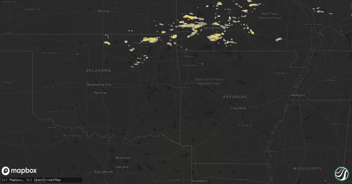
Hail Map on August 4, 2012
Get this storm
August 4 map
$229
one time, instant access
Download today. No call, no setup
Keep the $229
Bought the map and want the full workflow? Apply the entire $229 to a subscription within 7 days. None of it is wasted.
Every map, not just this one
This buys you this map. Subscription and you get every map we run, in the markets you choose from a few cities to whole states to nationwide. Plus real-time alerts the moment a storm fires.
Contact data
Name, contact info, occupancy, even credit band for addresses in the footprint. You go from where it hit to who to call.
Become the source they trust
Unlimited branding weather history reports on demand. You already have the documented answer ready for the property owner, and you are the one who showed up with it.
Property data and RoofTrace estimates
Pull up any address you have got, its value and the exact code rules for that jurisdiction, straight from One Click Code. Then RoofTrace estimates the squares, pitch, and roof value, priced the way you price.
States Impacted by Hail Map on August 4, 2012
Storm reports
Mississippi
| Date | Description |
|---|---|
| 08/04/20126:51 PM CDT | Reports of tree down on liberty church road and power outages on wickware road. |
| 08/03/20127:00 PM CDT | Reports of a powerline down due to fallen tree in newton. |
Illinois
| Date | Description |
|---|---|
| 08/04/20124:40 PM CDT | Minor flooding around cicero ave and 85th. |
| 08/04/20124:30 PM CDT | Power lines down |
| 08/04/20124:29 PM CDT | Numerous large trees snapped and uprooted. Time estimated per radar. |
| 08/04/20124:20 PM CDT | A local report indicates 60 MPH wind near 3 SW MIDWAY AIRPORT |
| 08/04/20124:06 PM CDT | At the amphitheatre |
| 08/04/20124:05 PM CDT | At intersection of algonquin and barrington rds. |
| 08/04/20124:00 PM CDT | At algonquin and roselle |
| 08/04/20123:56 PM CDT | Several power poles blown over nearly to ground /not snapped/ harlem rd 1 mi s of manhattan-monee rd. Time based on radar. |
| 08/04/20123:52 PM CDT | A local report indicates 58 MPH wind near DUPAGE AIRPORT |
| 08/04/20123:52 PM CDT | Relayed from k7sc |
| 08/04/20123:49 PM CDT | A local report indicates 60 MPH wind near ELGIN |
| 08/04/20123:48 PM CDT | A local report indicates 60 MPH wind near NEW LENOX |
| 08/04/20123:35 PM CDT | 14 inch maple tree fell on garage |
| 08/04/20123:31 PM CDT | A local report indicates 70 MPH wind near AURORA |
| 08/04/20123:30 PM CDT | Several large pine trees snapped. Caton farm road between rt 47 and ashley |
| 08/04/20123:27 PM CDT | Also heavy rain |
| 08/04/20123:26 PM CDT | 6-7 inches diameter down |
| 08/04/20123:15 PM CDT | Relayed via facebook |
| 08/04/20123:15 PM CDT | Several large trees downed across the southern part of kendall county. Time estimated per radar. |
| 08/04/20123:15 PM CDT | 600 freemont avenue. 26 inch diameter tree fell on house. One other tree split in half. |
| 08/04/20123:14 PM CDT | Trees down and trees on houses |
| 08/04/20123:11 PM CDT | Large treen downed along il highway 71 near the small town of norway. Time estimated per radar. |
| 08/04/20123:08 PM CDT | A local report indicates 75 MPH wind near 5 SW ROCKFORD |
| 08/04/20122:57 PM CDT | Chicago ave closed due to an estimated 1 to 1.5 foot diameter size tree down accross road. |
| 08/04/20122:56 PM CDT | Large tree downed. Time estimated per radar. |
| 08/04/20122:50 PM CDT | Numerous trees and powerlines downed. Time estimated per radar. |
| 08/04/20122:49 PM CDT | A local report indicates 58 MPH wind near 2 WNW FREEPORT |
| 08/04/20122:45 PM CDT | Report of power lines down across carroll county |
| 08/04/20122:30 PM CDT | Braches 6-8 inches in diameter down. 0.88 inches of rain. |
| 08/04/20122:25 PM CDT | A local report indicates 60 MPH wind near 5 N PEARL CITY |
| 08/04/20122:25 PM CDT | E40 to 60 mph winds with a report of two buildings down at the fairgrounds |
| 08/04/20122:25 PM CDT | Few large diameter tree branches down. Minor street flooding. 1.53 inches of rain so far. Via espotter |
| 08/04/20122:15 PM CDT | Huge oak tree went down in front of me. Numerous large branches down estimated 4-6 inch diameter. Estimated sustained winds 60 with gust over 70 mph. Via espotter. |
| 08/04/20122:14 PM CDT | Three foot tree diamater tree was blown down...power was also out in toulon |
| 08/04/20122:10 PM CDT | Several large tree branches also down. |
| 08/04/20122:05 PM CDT | Delayed report via espotter |
| 08/04/20121:57 PM CDT | Tree limbs down approximaely 3 inches in diameter along with very heavy rain. |
| 08/03/201211:55 PM CDT | Tree limbs down in town...some on power lines causing power outages. Some limbs on cars. |
| 08/03/201211:35 PM CDT | High winds snapped power pole... And blew large limb off an oak tree. Delayed report |
| 08/03/201211:26 PM CDT | Several limbs and power lines blown down. |
Pennsylvania
| Date | Description |
|---|---|
| 08/04/20122:35 PM CDT | Trees and wires down. |
| 08/04/20122:25 PM CDT | Tree down on red lane in mahoning township |
| 08/04/20122:20 PM CDT | Large tree across railroad tracks |
| 08/04/20122:08 PM CDT | Numerous reports of trees and wires down in the city of york. |
| 08/04/20121:50 PM CDT | Tree down blocking route 304 at zimmerman road |
| 08/04/20121:30 PM CDT | Several trees down on utility lines |
| 08/04/20121:20 PM CDT | Branches down. |
| 08/04/20121:13 PM CDT | Half dollar size hail reported. |
| 08/04/20121:10 PM CDT | Multiple large tree branches down along maple ave in horsham. Also... Fence blown over along route 611. |
| 08/04/20121:00 PM CDT | Trees and wires down in horsham twp. |
| 08/04/201212:45 PM CDT | Trees and wires down in abington twp. |
| 08/04/201211:45 AM CDT | Large limbs down. |
Arkansas
| Date | Description |
|---|---|
| 08/03/20129:35 PM CDT | Multiple tree limbs down in and around pea ridge. |
| 08/03/20129:32 PM CDT | Shingle damage to a home. |
| 08/03/20129:32 PM CDT | Trees downed on hwy 59 closed at sulphure springs...several power lines down in bella vista. |
| 08/03/20129:30 PM CDT | A local report indicates 65 MPH wind near 1 ENE BENTONVILLE |
| 08/03/20129:28 PM CDT | Many trees damaged by wind. Power lines downed. Roof damage to some homes. |
| 08/03/20129:15 PM CDT | Relayed measurement from a wind instrument on cooper elementary school on highway 71 in bella vista. |
| 08/03/20129:10 PM CDT | Tree blown into house. Power lines downed. Many trees damaged by wind. |
| 08/03/20129:00 PM CDT | Trees down in the area. |
Missouri
| Date | Description |
|---|---|
| 08/04/20126:55 PM CDT | A local report indicates 60 MPH wind near 3 NW EBENEZER |
| 08/04/20126:35 PM CDT | Roof off bank. Fire dept. Had doors blown in. Trees on houses. |
| 08/04/20126:30 PM CDT | Tree down over power lines. |
| 08/04/20126:12 PM CDT | Law enforcement reports numerous power lines down and power outages around the city. |
| 08/04/20126:12 PM CDT | Law enforcement reports several power lines and trees down around the city with power outages. |
| 08/04/20126:02 PM CDT | Nickel size hail and estimated wind gust of 58 mph was reported with this storm. |
| 08/04/201212:24 AM CDT | A local report indicates 60 MPH wind near REPUBLIC |
| 08/03/201210:39 PM CDT | Several trees blown down. |
| 08/03/201210:35 PM CDT | Severe thundertorm wind gusts downed large tree limbs. |
| 08/03/201210:35 PM CDT | Sheriff deputy estimated 60 mph wind gusts north of pineville. |
| 08/03/201210:33 PM CDT | Sheriff deputy reported 60 to 70 mph wind gusts south of lanagan. Said that the wind gusts nearly blew him off the roadway. |
| 08/03/201210:25 PM CDT | 3-6 inch diameter tree limbs blown down |
| 08/03/201210:25 PM CDT | A local report indicates 65 MPH wind near MARYLAND HEIGHTS |
| 08/03/201210:12 PM CDT | Several trees blown down. |
| 08/03/201210:10 PM CDT | Trees down |
| 08/03/201210:00 PM CDT | Heavy rain fell over the past hour. |
| 08/03/20129:50 PM CDT | One and one half foot diameter tree uprooted |
| 08/03/20129:47 PM CDT | Top of large maple tree snapped off by high winds. |
| 08/03/20129:38 PM CDT | 60 to 70 mph wind gust about 4 miles south of new haven. |
| 08/03/20129:21 PM CDT | Severe thunderstorm wind gusts downed several trees. |
| 08/03/20129:06 PM CDT | A local report indicates 59 MPH wind near REPUBLIC |
| 08/03/20129:05 PM CDT | Large branches blown down at city park. |
| 08/03/20129:04 PM CDT | A large tree was blown down. This tree fell on a house...causing significant damage to the house. |
| 08/03/20128:56 PM CDT | 60 mph wind gusts and penny size hail |
| 08/03/20128:55 PM CDT | Nickel hail also. |
| 08/03/20128:52 PM CDT | Power line down across road on cope dr. Near state highway z. |
| 08/03/20128:45 PM CDT | Large tree blown down. |
| 08/03/20128:40 PM CDT | Several large tree branches and power lines blown down. |
| 08/03/20128:40 PM CDT | Tree down |
| 08/03/20128:40 PM CDT | Two large trees down. |
| 08/03/20128:40 PM CDT | Several large trees down. |
| 08/03/20128:30 PM CDT | Few trees down along highway h. |
| 08/03/20128:12 PM CDT | Storm spotter estimated wind gust up to 70 mph on the northwest side of town near i-44 and kearney |
| 08/03/20128:08 PM CDT | A local report indicates 60 MPH wind near 5 N FAIR GROVE |
| 08/03/20128:05 PM CDT | Large tree blown down on golf course off chestnut expressway. |
| 08/03/20128:01 PM CDT | Public reports 60 mph wind gusts and trees down |
| 08/03/20127:58 PM CDT | A local report indicates 60 MPH wind near 5 N PLEASANT HOPE |
| 08/03/20127:58 PM CDT | Signal light down on the north side of the city. |
| 08/03/20127:55 PM CDT | *** 1 inj *** numerous trees down with one home damaged near goodnight hollow and round mountain roads. |
| 08/03/20127:51 PM CDT | Tree limbs down. |
| 08/03/20127:50 PM CDT | Flatbed trailer blown 20 yds at the ozark empire fair grounds. |
| 08/03/20127:45 PM CDT | Large tree branches blown down. |
| 08/03/20127:34 PM CDT | Large tree down blocking hwy 125. Report via espotter. |
| 08/03/20127:32 PM CDT | A local report indicates 60 MPH wind near 4 E ROLLA |
| 08/03/20127:28 PM CDT | A local report indicates 58 MPH wind near ASH GROVE |
| 08/03/20127:25 PM CDT | Trees down up to 14 inches in diameter. |
| 08/03/20127:25 PM CDT | A local report indicates 58 MPH wind near 1 N ASH GROVE |
| 08/03/20127:25 PM CDT | Tree blown down across highway 160. |
| 08/03/20127:15 PM CDT | Several trees and power lines down. |
| 08/03/20127:10 PM CDT | A local report indicates 1.50 inch wind near 1 ESE MILLER |
| 08/03/20127:05 PM CDT | A local report indicates 1.00 inch wind near MILLER |
New York
| Date | Description |
|---|---|
| 08/04/20126:40 PM CDT | Trees down on ide road near coomer in newfane |
| 08/04/20126:00 PM CDT | Tree limbs and wires down in newfane |
Oklahoma
| Date | Description |
|---|---|
| 08/04/20126:15 PM CDT | Tree damage. Large limbs broken. |
| 08/04/20126:04 PM CDT | Roof and barn damage near highway 10. Power poles broken. |
| 08/04/20125:47 PM CDT | Tree blown down onto a house. |
| 08/04/20125:38 PM CDT | Fence blown down. Round hay bales apparently thrown from one field to another. |
| 08/03/20129:00 PM CDT | Large tree limbs blown broken |
| 08/03/20128:43 PM CDT | A local report indicates 71 MPH wind near TULSA |
| 08/03/20127:00 PM CDT | Large branches and power lines down. |
Massachusetts
| Date | Description |
|---|---|
| 08/04/20124:57 PM CDT | Two trees down on wires. |
Kansas
| Date | Description |
|---|---|
| 08/04/20126:01 PM CDT | 15 to 25 power poles were downed from 2 miles west of crestline to crestline. |
Ohio
| Date | Description |
|---|---|
| 08/04/20126:00 PM CDT | Several trees down. Tree down on mulbury street. |
| 08/04/20125:50 AM CDT | One tree down at indian lake state park. Time estimated. |
| 08/04/20125:45 AM CDT | A tree fell and took down a power pole and hit the corner of a house. Time estimated. |
| 08/03/201210:45 PM CDT | Trees down in the city and outskirts. |
| 08/03/201210:00 PM CDT | Trees down in fairpark. |
| 08/03/20129:05 PM CDT | Telephone poles down. |
| 08/03/20129:00 PM CDT | A local report indicates 70 MPH wind near TOLEDO |
| 08/03/20129:00 PM CDT | Telephone poles down. |
| 08/03/20128:45 PM CDT | Large tree branch down. |
| 08/03/20128:42 PM CDT | Large tree down on lakewood |
| 08/03/20128:40 PM CDT | Large tree uprooted and fell on a house. |
| 08/03/20128:10 PM CDT | Power lines down and numerous tree limbs down across the county. |
| 08/03/20128:05 PM CDT | Two barns destroyed |
| 08/03/20127:44 PM CDT | A local report indicates 60 MPH wind near 4 W CONVOY |
| 08/03/20127:42 PM CDT | Numerous tree limbs down. Report relayed to nws by emergency manager. |
| 08/03/20127:24 PM CDT | A local report indicates 60 MPH wind near 1 E OAK HARBOR |
| 08/03/20127:06 PM CDT | Downed trees and power poles countywide. |
Indiana
| Date | Description |
|---|---|
| 08/04/20126:57 PM CDT | A local report indicates 65 MPH wind near JONESBORO |
| 08/04/20126:55 PM CDT | Along with winds in excess of 50 mph |
| 08/04/20126:52 PM CDT | Trees and power lines down on rangeline road and 500 n |
| 08/04/20126:50 PM CDT | Tree limbs downed and tree downed in roadway at county roads 400 north and 525 east. |
| 08/04/20126:50 PM CDT | 2 outbuildings damaged... One destroyed. Moderate damage to a home. |
| 08/04/20126:47 PM CDT | Large tree down on mckeever road. Time estimated from radar. |
| 08/04/20126:45 PM CDT | Tree down near county road 115n and route 24. |
| 08/04/20126:20 PM CDT | Tree downed on a home in tipton. |
| 08/04/20126:13 PM CDT | Estimated 65 mph winds at national weather service office. |
| 08/04/20126:01 PM CDT | Numerous trees down in warsaw...winona lake....and across northern portions of the county |
| 08/04/20125:50 PM CDT | A small tree reported down. |
| 08/04/20125:50 PM CDT | A local report indicates 65 MPH wind near 1 E ELKHART |
| 08/04/20125:48 PM CDT | Large branches down near county road 1. |
| 08/04/20125:43 PM CDT | Corn flattened. |
| 08/04/20125:38 PM CDT | A local report indicates 60 MPH wind near MISHAWAKA |
| 08/04/20125:38 PM CDT | Estimated 60 to 70 mph winds. Time estimated from radar. |
| 08/04/20125:35 PM CDT | Trees down throughout the county. Tree down across us31 south of 30. Lines down in culver which started a fire. |
| 08/04/20125:23 PM CDT | Intersection of rt 30 and burr. At 14 inch diameter tree which was 25 feet tall fell on house next to it. |
| 08/04/20125:20 PM CDT | Trees and power lines down. |
| 08/04/20125:10 PM CDT | 2 large trees down. |
| 08/04/20125:03 PM CDT | A local report indicates 66 MPH wind near 4 NW SOUTH BEND |
| 08/04/20124:58 PM CDT | A local report indicates 1.00 inch wind near OBER |
| 08/04/20124:57 PM CDT | Power lines down along us 421 near wanatah and hail slightly larger than quarters also reported. |
| 08/04/20124:57 PM CDT | Power lines down along us 421 near wanatah and hail slightly larger than quarters also reported. |
| 08/04/20124:53 PM CDT | A local report indicates 59 MPH wind near VALPARAISO |
| 08/04/20124:44 PM CDT | Ridge and cline |
| 08/04/20124:38 PM CDT | A local report indicates 1.00 inch wind near 2 E ALDINE |
| 08/04/20124:23 PM CDT | A local report indicates 61 MPH wind near GARY |
| 08/04/20122:05 PM CDT | One healty tree down across the road and partially onto a pick -up truck. Tree is about 50 feet tall and 16 to 18 inches in diameter. Location approx. |
| 08/04/20121:25 PM CDT | Measured at eagle creek asos. |
| 08/04/20126:00 AM CDT | Tree reported down on i-70 east near mm 153. Time estimated. |
| 08/04/20125:55 AM CDT | Tree down on college corner road near west grove road. Time estimated. |
| 08/04/20125:38 AM CDT | Tree down on plum street. Time estimated. |
| 08/04/20125:35 AM CDT | Trees downed near spiceland rd and cr400s. |
| 08/04/20124:45 AM CDT | Numerous trees down between 46th and 49th street and college and keystone. Much of the area also without power. |
| 08/04/20124:45 AM CDT | Power outages in noblesville area. |
| 08/04/20124:42 AM CDT | One tree down and another partially down. |
| 08/04/20124:15 AM CDT | Outbuilding damaged. |
| 08/04/20124:05 AM CDT | Large tree down blocking roadway. Time estimated from radar. Late report. |
| 08/03/20127:29 PM CDT | Large tree branches reported down. |
| 08/03/20127:29 PM CDT | Tree limbs and power lines down in portland and pennville |
| 08/03/20127:10 PM CDT | Large tree down across road near rockford. Large limbs down on 450 e and 100 n |
| 08/03/20127:10 PM CDT | Trees downed near kennard. |
| 08/03/20127:08 PM CDT | Large tree down near wayne street and 2nd. Time estimated from radar |
| 08/03/20127:02 PM CDT | A local report indicates 60 MPH wind near PARKER CITY |
| 08/03/20127:00 PM CDT | Maple tree snapped off eight feet above ground. Nearby trees also sustained tree limb damage. |
| 08/03/20127:00 PM CDT | Measured at the intersection of maplecrest and interstate 469 |
| 08/03/20127:00 PM CDT | Estimated size of nickel to quarter |
New Hampshire
| Date | Description |
|---|---|
| 08/04/20123:35 PM CDT | Trees down on patette hill road and tibbets hill road in northern portion of goffstown. Time approximate. |
Delaware
| Date | Description |
|---|---|
| 08/04/20121:23 PM CDT | Wires down along deer run road in townsend. |
New Jersey
| Date | Description |
|---|---|
| 08/04/201212:41 PM CDT | Wires down in maple shade. |
| 08/04/201212:35 PM CDT | Wires down in cinnaminson. |
| 08/04/201212:30 PM CDT | Trees and wires down in cherry hill. |
| 08/04/201212:30 PM CDT | Trees and wires down in pennsauken. |
Iowa
| Date | Description |
|---|---|
| 08/04/20122:55 PM CDT | Numerous up to 3 inch diameter limbs down |
| 08/04/20122:06 PM CDT | E50 mph winds producing small tree limbs down |
| 08/04/20122:01 PM CDT | A trained spotter reported an 18 to 24 inch tree down across north 3rd street in the city of clinton. |
| 08/04/20121:54 PM CDT | A local report indicates 60 MPH wind near DAVENPORT |
| 08/04/20121:35 PM CDT | Fruit tree downed |
| 08/04/20121:20 PM CDT | Time estimated |
| 08/04/20121:17 PM CDT | Report via espotter |
| 08/04/20121:16 PM CDT | Estimated 60 to 70 mph winds. Relayed by delaware county sheriffs office. |
| 08/04/20121:14 PM CDT | Report via espotter. |
| 08/04/20121:14 PM CDT | A local report indicates 65 MPH wind near 2 E BENNETT |
| 08/04/20121:12 PM CDT | A 5 inch tree limb down. Report was delayed. |
| 08/04/201212:55 PM CDT | Spotter report of 12 inch tree town. Report was delayed. |
| 08/04/201212:48 PM CDT | A trained spotter reported 3 to 4 inch diameter tree limbs down. Estimated wind gusts of 70 to 75 mph. |
| 08/04/201212:48 PM CDT | Estimated 60 to 65 mph. |
| 08/04/201212:48 PM CDT | Aluminum flag pole snapped and several trees damaged. |
| 08/04/201212:48 PM CDT | Estimated winds of 60 to 70 mph. Heavy rain is reducing visibility. |
| 08/04/201212:47 PM CDT | A trained spotter estimated thunderstorm winds of 06 to 65 mph. |
| 08/04/201212:47 PM CDT | A trained spotter estimated winds of 70 to 75 mph. |
| 08/04/201212:47 PM CDT | A local report indicates 73 MPH wind near CEDAR RAPIDS MUNICIPAL |
| 08/04/201212:40 PM CDT | A trained spotter estimated winds of 50 to 60 mph. |
| 08/04/201212:38 PM CDT | A local report indicates 72 MPH wind near CEDAR RAPIDS MUNICIPAL |
| 08/04/201212:36 PM CDT | A trained spotter reported estimated wind gusts of 50 to 60 mph. |
| 08/04/201212:35 PM CDT | A local report indicates 60 MPH wind near 5 NW IOWA CITY |
| 08/04/201212:35 PM CDT | 3 inch diameter tree branch down on home. Numerous smaller branches down. |
| 08/04/201212:28 PM CDT | Winds estimated at 60 to 65 mph with heavy rain with visibility of a quarter of a mile or less. |
| 08/04/201212:25 PM CDT | Spotter estimated sustained 40 gust 60-70 mph. |
| 08/04/201212:25 PM CDT | Trees down and windows blown out of a residence. A grain bin is also reported down. Delayed report. |
Vermont
| Date | Description |
|---|---|
| 08/04/20123:05 PM CDT | Sizes varying from dimes to a quarter |
| 08/04/20122:48 PM CDT | Two 8 to 10 inch diameter trees blown over |
Tennessee
| Date | Description |
|---|---|
| 08/04/20122:52 PM CDT | One tree snapped and several tree limbs blown down along maple hill road north of carver lane |
Michigan
| Date | Description |
|---|---|
| 08/04/20125:52 PM CDT | Four trees down. Time estimated from radar. |
| 08/04/20125:38 PM CDT | Large tree branch down. Time estimated from radar. |
| 08/04/20125:33 PM CDT | 6 inch to 1 foot tree limbs and trees down. Also hail the size of ping pong balls. |
| 08/04/20125:33 PM CDT | 6 inch to 1 foot tree limbs and trees down. Also hail the size of ping pong balls. |
Cities Impacted by Hail Map on August 4, 2012
- Rolla, MO
- Newburg, MO
- Geneva, IN
- Celina, OH
- Portland, IN
- Rockford, OH
- Berne, IN
- Bryant, IN
- Ponca City, OK
- Knox, IN
- Tipton, IN
- Long Lane, MO
- Conway, MO
- Elkland, MO
- Putnam, IL
- Morrison, IL
- Bryant, IA
- Sterling, IL
- Clinton, IA
- Fulton, IL
- Chadwick, IL
- Thomson, IL
- Charlotte, TN
- Danville, AL
- Moulton, AL
- Bay Springs, MS
- Louin, MS
- Dowagiac, MI
- Niles, MI
- Hudson, KY
- Big Clifty, KY
- Leslie, MO
- Chamois, MO
- Mount Sterling, MO
- Freeburg, MO
- Linn, MO
- Gerald, MO
- Owensville, MO
- New Haven, MO
- Hermann, MO
- Morrison, MO
- Bland, MO
- Rosebud, MO
- Belle, MO
- Milton, IN
- Falmouth, IN
- Hagerstown, IN
- Straughn, IN
- Mays, IN
- New Castle, IN
- Connersville, IN
- Cambridge City, IN
- Lewisville, IN
- Knightstown, IN
- Rushville, IN
- Edna, KS
- Troy, MO
- Foristell, MO
- Jasper, MO
- Harlan, IN
- Antwerp, OH
- New Haven, IN
- Woodburn, IN
- Bristol, FL
- Piqua, OH
- Troy, OH
- Fletcher, OH
- Bellefontaine, OH
- Decatur, IN
- Willshire, OH
- Uniondale, IN
- Ossian, IN
- Ohio City, OH
- Monroe, IN
- Bluffton, IN
- Continental, OH
- Paulding, OH
- Payne, OH
- Oakwood, OH
- Melrose, OH
- Convoy, OH
- Fort Jennings, OH
- Van Wert, OH
- Cloverdale, OH
- Scott, OH
- Delphos, OH
- Cecil, OH
- Venedocia, OH
- Defiance, OH
- Latty, OH
- Grover Hill, OH
- Haviland, OH
- Middle Point, OH
- Athens, IL
- Sparta, MO
- Spokane, MO
- Highlandville, MO
- Galena, MO
- Forsyth, MO
- Ponce De Leon, MO
- Ozark, MO
- Oldfield, MO
- Chadwick, MO
- Bruner, MO
- Baker, LA
- Zachary, LA
- Thayer, KS
- Goldsmith, IN
- Atlanta, IN
- Sharpsville, IN
- Oronogo, MO
- Lebanon, MO
- Ransom, IL
- Portage, OH
- Rudolph, OH
- Kendallville, IN
- Pittsburg, KS
- Weir, KS
- Asbury, MO
- Galena, KS
- Carl Junction, MO
- Nashua, NH
- Hillsdale, IN
- Saint Henry, OH
- Fenton, IL
- Erie, IL
- Stevensville, MI
- Grovespring, MO
- Niangua, MO
- Vienna, MO
- East Berlin, PA
- Dillsburg, PA
- Wellsville, PA
- Dover, PA
- Richland, MO
- Vine Grove, KY
- Craigville, IN
- Plainfield, MA
- Ashfield, MA
- Leroy, AL
- House, NM
- Mcalister, NM
- Fitchburg, MA
- Lunenburg, MA
- Leominster, MA
- Casstown, OH
- Saint Paris, OH
- Sidney, OH
- Conover, OH
- Garrison, IA
- Peru, IN
- Dayton, OH
- Chetopa, KS
- Eaton, OH
- Ottawa, IL
- Walnut Grove, MO
- New Boston, NH
- Carthage, MO
- Mound Valley, KS
- Royalston, MA
- Fort Sumner, NM
- Vinton, IA
- Royal Center, IN
- Sigourney, IA
- Arlington, IN
- West Brooklyn, IL
- Ashton, IL
- Dixon, MO
- Albion, IN
- Laotto, IN
- Churubusco, IN
- Avilla, IN
- Duke, MO
- La Russell, MO
- Stotts City, MO
- Alger, OH
- Ada, OH
- Harrod, OH
- Schneider, IN
- Lowell, IN
- Grant Park, IL
- Crown Point, IN
- Hebron, IN
- Yorkville, IL
- Newark, IL
- Afton, OK
- Fairland, OK
- Grove, OK
- Fortville, IN
- Pendleton, IN
- Ingalls, IN
- Gorham, IL
- Murphysboro, IL
- Reedsville, WI
- Greenleaf, WI
- Denmark, WI
- Maribel, WI
- Whitelaw, WI
- Rineyville, KY
- Elizabethtown, KY
- Rhineland, MO
- Portland, MO
- Birmingham, AL
- Louisa, KY
- Pontiac, IL
- Bremen, IN
- Findlay, OH
- Arlington, OH
- Mount Blanchard, OH
- Clarinda, IA
- New Market, IA
- Calamus, IA
- Poplar Bluff, MO
- Grandin, MO
- Doniphan, MO
- Cayuga, IN
- Drury, MA
- Anderson, IN
- Monroeville, IN
- Vichy, MO
- Remington, IN
- Wolcott, IN
- Granger, IA
- Dallas Center, IA
- Catoosa, OK
- Owasso, OK
- Poneto, IN
- Markle, IN
- Warren, IN
- Liberty Center, IN
- Lockwood, MO
- University Park, IL
- Park Forest, IL
- Steger, IL
- Crete, IL
- Walton, IN
- Galveston, IN
- Logansport, IN
- Lenapah, OK
- Delaware, OK
- Vinita, OK
- Valparaiso, IN
- Wanatah, IN
- Elmo, MO
- Westboro, MO
- Pierce City, MO
- Stark City, MO
- Walnut Shade, MO
- Reeds Spring, MO
- Chestnutridge, MO
- Townsend, MA
- West Townsend, MA
- Pawhuska, OK
- Arcadia, IN
- Windfall, IN
- Kempton, IN
- Elwood, IN
- Kokomo, IN
- Swayzee, IN
- Frankfort, IN
- Greentown, IN
- Cicero, IN
- Sheridan, IN
- Fairmount, IN
- Jonesboro, IN
- Ainsworth, IA
- Ash Grove, MO
- Everton, MO
- Wabash, IN
- Lima, OH
- Wapakoneta, OH
- Seymour, MO
- Hillsborough, NH
- Walnut, IL
- Harmon, IL
- Tampico, IL
- Deer Grove, IL
- Saint Francisville, LA
- Woodville, MS
- Blackwell, OK
- Catawissa, MO
- Labadie, MO
- Robertsville, MO
- Gray Summit, MO
- Pacific, MO
- Brownsburg, IN
- Pittsboro, IN
- De Witt, IA
- Quapaw, OK
- Verona, MO
- Des Moines, IA
- Livingston, TN
- Flemington, MO
- Wheatland, MO
- College Springs, IA
- Blanchard, IA
- Thorntown, IN
- Union Mills, IN
- La Crosse, IN
- Charlotte, IA
- Crystal City, MO
- Festus, MO
- Hillsboro, MO
- Mokane, MO
- Steedman, MO
- Creal Springs, IL
- Newton, MS
- Harrisburg, PA
- Chicago, IL
- Hartford City, IN
- Eaton, IN
- Muncie, IN
- Rochelle, IL
- Otley, IA
- Pella, IA
- Mount Vernon, IA
- Goose Lake, IA
- Grand Mound, IA
- Hampshire, TN
- Tulsa, OK
- Sand Springs, OK
- Lamar, MO
- Argos, IN
- Dickson, TN
- Bon Aqua, TN
- Rossville, IL
- Danville, IL
- Alvin, IL
- Springfield, MO
- Fair Grove, MO
- Marshfield, MO
- Strafford, MO
- Sturgis, KY
- Hardaway, AL
- Miami, OK
- Newtown, IN
- New Richmond, IN
- Covington, IN
- Wingate, IN
- Mellott, IN
- Veedersburg, IN
- Attica, IN
- Williamsport, IN
- Westpoint, IN
- Momence, IL
- New Ipswich, NH
- Columbia City, IN
- Andrews, IN
- La Fontaine, IN
- Huntington, IN
- Marion, IN
- Van Buren, IN
- Oskaloosa, IA
- Brighton, IA
- Beech Grove, IN
- Indianapolis, IN
- Fort Wayne, IN
- Fordland, MO
- Monett, MO
- Wentworth, MO
- Mount Vernon, MO
- Merrillville, IN
- Miller, MO
- Bennington, VT
- Richland, IA
- Sapulpa, OK
- Morgantown, KY
- Warsaw, IN
- Pierceton, IN
- Winona Lake, IN
- New Cumberland, PA
- Etters, PA
- Lewisberry, PA
- Wyandotte, OK
- Seneca, MO
- Saint Anne, IL
- Pembroke Township, IL
- Geneseo, IL
- Le Claire, IA
- Eldridge, IA
- Bettendorf, IA
- Davenport, IA
- Prairie City, IA
- Reasnor, IA
- Hartford, IA
- Swan, IA
- Knoxville, IA
- Pleasantville, IA
- Monroe, IA
- Runnells, IA
- New Sharon, IA
- Greenfield, IN
- Rockville, IN
- Greencastle, IN
- Russellville, IN
- Arcola, MO
- Golden City, MO
- Jerico Springs, MO
- Greenfield, MO
- Newport, PA
- Collison, IL
- Mansfield, MO
- Villa Ridge, MO
- Rock Port, MO
- Wilton, IA
- New Liberty, IA
- Stockton, IA
- Eldred, IL
- Peotone, IL
- Bonfield, IL
- Manteno, IL
- Bourbonnais, IL
- Kankakee, IL
- Wilmington, IL
- Manhattan, IL
- Montezuma, IA
- Kouts, IN
- South Bend, IN
- Selma, IN
- Parker City, IN
- Lenox, MO
- Earlville, IL
- Mazon, IL
- Millbrook, IL
- Leland, IL
- Oswego, IL
- Marseilles, IL
- Morris, IL
- Plano, IL
- Kinsman, IL
- Serena, IL
- Bristol, IL
- Somonauk, IL
- Minooka, IL
- Seneca, IL
- Verona, IL
- Montgomery, IL
- Wedron, IL
- Utica, IL
- Sheridan, IL
- Sandwich, IL
- Millington, IL
- Culver, IN
- Hickory, MS
- Westville, IN
- Grovertown, IN
- Milledgeville, IL
- Mountain View, MO
- Jerry City, OH
- McComb, OH
- Malinta, OH
- Custar, OH
- North Baltimore, OH
- Cygnet, OH
- Leipsic, OH
- Hamler, OH
- Holgate, OH
- Hoytville, OH
- Deshler, OH
- Markleville, IN
- Wright City, MO
- Wentzville, MO
- Tonkawa, OK
- Hartville, MO
- Sedan, KS
- Cedar Vale, KS
- East Alton, IL
- Russellville, KY
- Lewisburg, KY
- Muscatine, IA
- Blue Grass, IA
- Lizton, IN
- Lebanon, IN
- Urbana, MO
- Tunas, MO
- What Cheer, IA
- Keswick, IA
- Rose Hill, IA
- Delta, IA
- Huntsville, AR
- Waynesville, MO
- Saint Robert, MO
- Willow Springs, MO
- Summersville, MO
- Aroma Park, IL
- Goffstown, NH
- Goshen, IN
- New Paris, IN
- Millersburg, IN
- Winchester, IN
- Walkerton, IN
- Hamlet, IN
- La Porte, IN
- Hanna, IN
- Clarksville, TN
- Merrimack, NH
- Macks Creek, MO
- Mendota, IL
- La Salle, IL
- Luxemburg, WI
- New Palestine, IN
- Fountaintown, IN
- Ludlow Falls, OH
- Rochester, IN
- Greenwell Springs, LA
- Dewey, OK
- Nowata, OK
- Bartlesville, OK
- Wann, OK
- Welch, OK
- Bluejacket, OK
- Garfield, KY
- Irvington, KY
- Harned, KY
- Custer, KY
- Waynesfield, OH
- Fort Leonard Wood, MO
- Edgar Springs, MO
- Rochester, IL
- Burbank, OK
- North Clarendon, VT
- Losantville, IN
- Mooreland, IN
- Modoc, IN
- Farmland, IN
- Lawrenceburg, TN
- Buffalo, MO
- Tiskilwa, IL
- Princeton, IL
- Wyanet, IL
- Blackstone, IL
- Hamel, IL
- Edwardsville, IL
- Newkirk, OK
- Cumming, IA
- Urbandale, IA
- Waukee, IA
- Windsor Heights, IA
- Clive, IA
- West Des Moines, IA
- Plato, MO
- Capitan, NM
- Kenton, OH
- Mount Victory, OH
- Florence, AL
- Kewanna, IN
- Falcon, MO
- Saint Martinville, LA
- Alexandria, IN
- Tippecanoe, IN
- Anderson, MO
- Lanagan, MO
- Pineville, MO
- Walcott, IA
- Tipton, IA
- Durant, IA
- West Branch, IA
- Donahue, IA
- Welton, IA
- Bennett, IA
- Wheatland, IA
- Moscow, IA
- Long Grove, IA
- Dixon, IA
- Delmar, IA
- Atalissa, IA
- West Liberty, IA
- Harper, IA
- Corinth, MS
- Converse, IN
- Bonnots Mill, MO
- Decatur, MS
- Little Rock, MS
- Dunstable, MA
- Groton, MA
- Saint James, MO
- Cook Sta, MO
- Thornfield, MO
- Wasola, MO
- Noble, MO
- Squires, MO
- Gainesville, MO
- Brixey, MO
- Braman, OK
- Grabill, IN
- Reeds, MO
- Sarcoxie, MO
- Taneyville, MO
- Weaubleau, MO
- Uriah, AL
- Sperry, OK
- Marthasville, MO
- Hoagland, IN
- Claremore, OK
- Boswell, IN
- Fort Recovery, OH
- South Greenfield, MO
- Houston, MO
- Cabool, MO
- Webb City, MO
- Alba, MO
- Kirklin, IN
- New Carlisle, IN
- Rolling Prairie, IN
- Mill Creek, IN
- North Liberty, IN
- Lucedale, MS
- Williamsburg, IA
- Paw Paw, IL
- Compton, IL
- Steelville, MO
- Barnsdall, OK
- Granville, IL
- Hennepin, IL
- Depue, IL
- Spring Valley, IL
- Summitville, IN
- Gaston, IN
- Monterey, IN
- Leesburg, IN
- Mentone, IN
- Milford, IN
- Star City, IN
- Nappanee, IN
- Wakarusa, IN
- Winamac, IN
- Bourbon, IN
- Etna Green, IN
- Kimmell, IN
- Ligonier, IN
- Cromwell, IN
- Fayette, MS
- Florence, VT
- Pittsford, VT
- Otterbein, IN
- West Lafayette, IN
- Cecilia, KY
- Eastview, KY
- Westford, MA
- Littleton, MA
- Elk Creek, MO
- Plymouth, IN
- Jenera, OH
- Dyer, IN
- Lake Village, IN
- Hobart, IN
- Beecher, IL
- San Pierre, IN
- Portage, IN
- Saint John, IN
- Wheatfield, IN
- Morocco, IN
- Cedar Lake, IN
- North Judson, IN
- Kingsford Heights, IN
- Columbus, KS
- Purcell, MO
- Avilla, MO
- Neck City, MO
- Willard, MO
- Freistatt, MO
- Granby, MO
- Oswego, KS
- Roby, MO
- Hoopeston, IL
- Eau Claire, MI
- Benton Harbor, MI
- Theodosia, MO
- Ava, MO
- Adams, TN
- Wood River, IL
- Covington, OH
- Pleasant Hill, OH
- Dorset, VT
- Coatesville, IN
- Stilesville, IN
- Wilmington, VT
- Union City, IN
- Union City, OH
- Jamestown, IN
- Celina, TN
- Leasburg, MO
- Dunkirk, IN
- Union, MO
- Russiaville, IN
- Carbondale, IL
- Bellflower, MO
- Joplin, MO
- Carrollton, IL
- Donovan, IL
- Beaverville, IL
- Louisburg, MO
- Valders, WI
- Melrose, NM
- Odell, IL
- Carmel, IN
- Zionsville, IN
- Scammon, KS
- Wagarville, AL
- Saint Stephens, AL
- Oglesby, IL
- Peru, IL
- New Weston, OH
- Colfax, IA
- Leitchfield, KY
- McDaniels, KY
- Westview, KY
- Mountain Grove, MO
- Osceola, IN
- Tuscumbia, AL
- Sheffield, AL
- Muscle Shoals, AL
- Ottawa, OH
- Columbus Grove, OH
- Loretto, TN
- Petersburg, IL
- Tallula, IL
- North English, IA
- South English, IA
- Mooresville, IN
- Camby, IN
- Lime Springs, IA
- Skiatook, OK
- Prairie Du Rocher, IL
- Coldwater, OH
- Arlington, IL
- New Ross, IN
- Ladoga, IN
- Crawfordsville, IN
- Bedford, IA
- Gravity, IA
- Buda, IL
- Sheffield, IL
- Bradleyville, MO
- Charlottesville, IN
- Wilkinson, IN
- Mechanicsburg, IL
- Dawson, IL
- Stockton, MO
- Show Low, AZ
- Crawfordsville, IA
- Gardner, IL
- Dwight, IL
- Hermitage, MO
- North Manchester, IN
- South Whitley, IN
- Barnes City, IA
- Brownsville, KY
- Beaverdam, OH
- Bluffton, OH
- Raleigh, MS
- Opdyke, IL
- Mount Vernon, IL
- Decatur, MI
- Jackson, AL
- Clinton, LA
- Springfield, IL
- Washington, MO
- Tarkio, MO
- Coin, IA
- Charlemont, MA
- Caneyville, KY
- Huntertown, IN
- Cuttingsville, VT
- Bradford, IL
- Graff, MO
- Huggins, MO
- Lafayette, IN
- Warwick, MA
- Northfield, MA
- Dixon, IL
- Pleasant Hill, IA
- Altoona, IA
- Mitchellville, IA
- Horse Branch, KY
- Cromwell, KY
- Williamstown, OH
- Dunkirk, OH
- Forest, OH
- Chunky, MS
- Iowa City, IA
- Brooks, KY
- Shepherdsville, KY
- Spencerville, OH
- Buckland, OH
- New Knoxville, OH
- Saint Marys, OH
- Mingo, IA
- Baxter, IA
- Collins, IA
- Rhodes, IA
- Angola, LA
- Hope Hull, AL
- Warrenton, MO
- Montpelier, IN
- Upland, IN
- Licking, MO
- Lyles, TN
- Rogersville, MO
- Danby, VT
- Plainfield, IN
- Clayton, IN
- Buchanan, MI
- Galien, MI
- Danville, IN
- Whitestown, IN
- Cornell, IL
- Avon, IL
- Prairie City, IL
- Orange, MA
- Winchester, NH
- Braddyville, IA
- Bonnie, IL
- Darlington, IN
- North Salem, IN
- Roachdale, IN
- Medaryville, IN
- Tyngsboro, MA
- Hollis, NH
- Shirley, IN
- Albany, IN
- Sublette, IL
- Collinsville, OK
- Garrett, IN
- Tuskegee, AL
- Tallassee, AL
- Berrien Springs, MI
- Baroda, MI
- Clinton Township, MI
- Romeoville, IL
- Shorewood, IL
- Joliet, IL
- Plainfield, IL
- Warner, NH
- Pomona, IL
- Makanda, IL
- Kingman, IN
- Hillsboro, IN
- Westfield, IN
- Henry, IL
- Ashley, MI
- Saint Johns, MI
- East Wallingford, VT
- Wallingford, VT
- Luzerne, IA
- Three Oaks, MI
- Port Byron, IL
- Hillsdale, IL
- Oakford, IL
- Pine Village, IN
- Oxford, IN
- Monclova, OH
- South Amana, IA
- Homestead, IA
- Marengo, IA
- Conroy, IA
- Liberty, MS
- Norwood, LA
- Rosewood, OH
- West Liberty, OH
- Urbana, OH
- De Graff, OH
- Fulton, MO
- Lake Saint Louis, MO
- Tebbetts, MO
- Augusta, MO
- Dittmer, MO
- Cedar Hill, MO
- Truesdale, MO
- Defiance, MO
- Loose Creek, MO
- Beaufort, MO
- Spencerville, IN
- Auburn, IN
- Leo, IN
- Romney, IN
- Bremen, KY
- Minor Hill, TN
- Middle Amana, IA
- Shelby, IN
- Demotte, IN
- Thayer, IN
- Millerstown, PA
- Washington, IA
- West Chester, IA
- Keota, IA
- Princeton, IA
- Cordova, IL
- Center Point, IA
- Thomasville, PA
- Abbottstown, PA
- New Oxford, PA
- Marion, OH
- Michigan City, IN
- Chesterton, IN
- Munford, AL
- Talladega, AL
- Centerville, TN
- Anna, OH
- Meadville, MS
- Jaffrey, NH
- Troy, NH
- Falls Of Rough, KY
- Bethalto, IL
- Alton, IL
- Cottage Hills, IL
- Alhambra, IL
- Moro, IL
- Worden, IL
- Lebanon, TN
- Grosse Tete, LA
- Weare, NH
- Prophetstown, IL
- Waveland, IN
- Quincy, OH
- Maplewood, OH
- Jackson Center, OH
- Lewistown, OH
- Botkins, OH
- Waynetown, IN
- Saint Joe, IN
- Cresco, IA
- Crane, MO
- Garrison, MO
- Homer Glen, IL
- Lockport, IL
- Leighton, IA
- Carlisle, IA
- Sully, IA
- Parsons, KS
- McCune, KS
- Palos Hills, IL
- Lemont, IL
- Palos Park, IL
- Willow Springs, IL
- Orland Park, IL
- Westpoint, TN
- Waynesboro, TN
- Commerce, OK
- Braidwood, IL
- Essex, IL
- Braceville, IL
- New Lenox, IL
- Frankfort, IL
- Monee, IL
- Johnston, IA
- Wayland, IA
- New Bremen, OH
- Brook, IN
- New Carlisle, OH
- Arcanum, OH
- Easton, PA
- Hellertown, PA
- Bismarck, IL
- West Lebanon, IN
- Spiceland, IN
- Springport, IN
- Redkey, IN
- Middletown, IN
- Fairland, IN
- Carthage, IN
- Ridgeville, IN
- Solo, MO
- Cuba, MO
- Bourbon, MO
- Duck River, TN
- Fairborn, OH
- Ringwood, OK
- Yoder, IN
- Roanoke, IN
- Belle Plaine, IA
- Chandlerville, IL
- Vanlue, OH
- Corunna, IN
- Mendon, OH
- Brookhaven, MS
- Wesson, MS
- Salem, MO
- Clay, KY
- Deep River, IA
- Maria Stein, OH
- Chickasaw, OH
- Grimes, IA
- Larwill, IN
- Mechanicsburg, PA
- Dadeville, MO
- Sawyer, MI
- Bridgman, MI
- Harbert, MI
- Noblesville, IN
- Wynona, OK