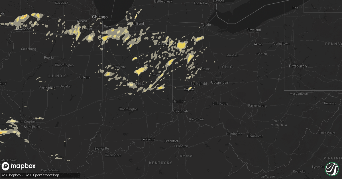
Hail Map in Illinois on August 4, 2012
Get this storm
August 4 map
$229
one time, instant access
Download today. No call, no setup
Keep the $229
Bought the map and want the full workflow? Apply the entire $229 to a subscription within 7 days. None of it is wasted.
Every map, not just this one
This buys you this map. Subscription and you get every map we run, in the markets you choose from a few cities to whole states to nationwide. Plus real-time alerts the moment a storm fires.
Contact data
Name, contact info, occupancy, even credit band for addresses in the footprint. You go from where it hit to who to call.
Become the source they trust
Unlimited branding weather history reports on demand. You already have the documented answer ready for the property owner, and you are the one who showed up with it.
Property data and RoofTrace estimates
Pull up any address you have got, its value and the exact code rules for that jurisdiction, straight from One Click Code. Then RoofTrace estimates the squares, pitch, and roof value, priced the way you price.
Storm reports in Illinois
Illinois
| Date | Description |
|---|---|
| 08/04/20124:40 PM CDT | Minor flooding around cicero ave and 85th. |
| 08/04/20124:30 PM CDT | Power lines down |
| 08/04/20124:29 PM CDT | Numerous large trees snapped and uprooted. Time estimated per radar. |
| 08/04/20124:20 PM CDT | A local report indicates 60 MPH wind near 3 SW MIDWAY AIRPORT |
| 08/04/20124:06 PM CDT | At the amphitheatre |
| 08/04/20124:05 PM CDT | At intersection of algonquin and barrington rds. |
| 08/04/20124:00 PM CDT | At algonquin and roselle |
| 08/04/20123:56 PM CDT | Several power poles blown over nearly to ground /not snapped/ harlem rd 1 mi s of manhattan-monee rd. Time based on radar. |
| 08/04/20123:52 PM CDT | Relayed from k7sc |
| 08/04/20123:52 PM CDT | A local report indicates 58 MPH wind near DUPAGE AIRPORT |
| 08/04/20123:49 PM CDT | A local report indicates 60 MPH wind near ELGIN |
| 08/04/20123:48 PM CDT | A local report indicates 60 MPH wind near NEW LENOX |
| 08/04/20123:35 PM CDT | 14 inch maple tree fell on garage |
| 08/04/20123:31 PM CDT | A local report indicates 70 MPH wind near AURORA |
| 08/04/20123:30 PM CDT | Several large pine trees snapped. Caton farm road between rt 47 and ashley |
| 08/04/20123:27 PM CDT | Also heavy rain |
| 08/04/20123:26 PM CDT | 6-7 inches diameter down |
| 08/04/20123:15 PM CDT | Relayed via facebook |
| 08/04/20123:15 PM CDT | 600 freemont avenue. 26 inch diameter tree fell on house. One other tree split in half. |
| 08/04/20123:15 PM CDT | Several large trees downed across the southern part of kendall county. Time estimated per radar. |
| 08/04/20123:14 PM CDT | Trees down and trees on houses |
| 08/04/20123:11 PM CDT | Large treen downed along il highway 71 near the small town of norway. Time estimated per radar. |
| 08/04/20123:08 PM CDT | A local report indicates 75 MPH wind near 5 SW ROCKFORD |
| 08/04/20122:57 PM CDT | Chicago ave closed due to an estimated 1 to 1.5 foot diameter size tree down accross road. |
| 08/04/20122:56 PM CDT | Large tree downed. Time estimated per radar. |
| 08/04/20122:50 PM CDT | Numerous trees and powerlines downed. Time estimated per radar. |
| 08/04/20122:49 PM CDT | A local report indicates 58 MPH wind near 2 WNW FREEPORT |
| 08/04/20122:45 PM CDT | Report of power lines down across carroll county |
| 08/04/20122:30 PM CDT | Braches 6-8 inches in diameter down. 0.88 inches of rain. |
| 08/04/20122:25 PM CDT | Few large diameter tree branches down. Minor street flooding. 1.53 inches of rain so far. Via espotter |
| 08/04/20122:25 PM CDT | E40 to 60 mph winds with a report of two buildings down at the fairgrounds |
| 08/04/20122:25 PM CDT | A local report indicates 60 MPH wind near 5 N PEARL CITY |
| 08/04/20122:15 PM CDT | Huge oak tree went down in front of me. Numerous large branches down estimated 4-6 inch diameter. Estimated sustained winds 60 with gust over 70 mph. Via espotter. |
| 08/04/20122:14 PM CDT | Three foot tree diamater tree was blown down...power was also out in toulon |
| 08/04/20122:10 PM CDT | Several large tree branches also down. |
| 08/04/20122:05 PM CDT | Delayed report via espotter |
| 08/04/20121:57 PM CDT | Tree limbs down approximaely 3 inches in diameter along with very heavy rain. |
| 08/03/201211:55 PM CDT | Tree limbs down in town...some on power lines causing power outages. Some limbs on cars. |
| 08/03/201211:35 PM CDT | High winds snapped power pole... And blew large limb off an oak tree. Delayed report |
| 08/03/201211:26 PM CDT | Several limbs and power lines blown down. |
All States Impacted by Hail Map on August 4, 2012
Cities Impacted by Hail Map on August 4, 2012
- Rolla, MO
- Newburg, MO
- Geneva, IN
- Celina, OH
- Portland, IN
- Rockford, OH
- Berne, IN
- Bryant, IN
- Ponca City, OK
- Knox, IN
- Tipton, IN
- Long Lane, MO
- Conway, MO
- Elkland, MO
- Putnam, IL
- Morrison, IL
- Bryant, IA
- Sterling, IL
- Clinton, IA
- Fulton, IL
- Chadwick, IL
- Thomson, IL
- Charlotte, TN
- Danville, AL
- Moulton, AL
- Bay Springs, MS
- Louin, MS
- Dowagiac, MI
- Niles, MI
- Hudson, KY
- Big Clifty, KY
- Leslie, MO
- Chamois, MO
- Mount Sterling, MO
- Freeburg, MO
- Linn, MO
- Gerald, MO
- Owensville, MO
- New Haven, MO
- Hermann, MO
- Morrison, MO
- Bland, MO
- Rosebud, MO
- Belle, MO
- Milton, IN
- Falmouth, IN
- Hagerstown, IN
- Straughn, IN
- Mays, IN
- New Castle, IN
- Connersville, IN
- Cambridge City, IN
- Lewisville, IN
- Knightstown, IN
- Rushville, IN
- Edna, KS
- Troy, MO
- Foristell, MO
- Jasper, MO
- Harlan, IN
- Antwerp, OH
- New Haven, IN
- Woodburn, IN
- Bristol, FL
- Piqua, OH
- Troy, OH
- Fletcher, OH
- Bellefontaine, OH
- Decatur, IN
- Willshire, OH
- Uniondale, IN
- Ossian, IN
- Ohio City, OH
- Monroe, IN
- Bluffton, IN
- Continental, OH
- Paulding, OH
- Payne, OH
- Oakwood, OH
- Melrose, OH
- Convoy, OH
- Fort Jennings, OH
- Van Wert, OH
- Cloverdale, OH
- Scott, OH
- Delphos, OH
- Cecil, OH
- Venedocia, OH
- Defiance, OH
- Latty, OH
- Grover Hill, OH
- Haviland, OH
- Middle Point, OH
- Athens, IL
- Sparta, MO
- Spokane, MO
- Highlandville, MO
- Galena, MO
- Forsyth, MO
- Ponce De Leon, MO
- Ozark, MO
- Oldfield, MO
- Chadwick, MO
- Bruner, MO
- Baker, LA
- Zachary, LA
- Thayer, KS
- Goldsmith, IN
- Atlanta, IN
- Sharpsville, IN
- Oronogo, MO
- Lebanon, MO
- Ransom, IL
- Portage, OH
- Rudolph, OH
- Kendallville, IN
- Pittsburg, KS
- Weir, KS
- Asbury, MO
- Galena, KS
- Carl Junction, MO
- Nashua, NH
- Hillsdale, IN
- Saint Henry, OH
- Fenton, IL
- Erie, IL
- Stevensville, MI
- Grovespring, MO
- Niangua, MO
- Vienna, MO
- East Berlin, PA
- Dillsburg, PA
- Wellsville, PA
- Dover, PA
- Richland, MO
- Vine Grove, KY
- Craigville, IN
- Plainfield, MA
- Ashfield, MA
- Leroy, AL
- House, NM
- Mcalister, NM
- Fitchburg, MA
- Lunenburg, MA
- Leominster, MA
- Casstown, OH
- Saint Paris, OH
- Sidney, OH
- Conover, OH
- Garrison, IA
- Peru, IN
- Dayton, OH
- Chetopa, KS
- Eaton, OH
- Ottawa, IL
- Walnut Grove, MO
- New Boston, NH
- Carthage, MO
- Mound Valley, KS
- Royalston, MA
- Fort Sumner, NM
- Vinton, IA
- Royal Center, IN
- Sigourney, IA
- Arlington, IN
- West Brooklyn, IL
- Ashton, IL
- Dixon, MO
- Albion, IN
- Laotto, IN
- Churubusco, IN
- Avilla, IN
- Duke, MO
- La Russell, MO
- Stotts City, MO
- Alger, OH
- Ada, OH
- Harrod, OH
- Schneider, IN
- Lowell, IN
- Grant Park, IL
- Crown Point, IN
- Hebron, IN
- Yorkville, IL
- Newark, IL
- Afton, OK
- Fairland, OK
- Grove, OK
- Fortville, IN
- Pendleton, IN
- Ingalls, IN
- Gorham, IL
- Murphysboro, IL
- Reedsville, WI
- Greenleaf, WI
- Denmark, WI
- Maribel, WI
- Whitelaw, WI
- Rineyville, KY
- Elizabethtown, KY
- Rhineland, MO
- Portland, MO
- Birmingham, AL
- Louisa, KY
- Pontiac, IL
- Bremen, IN
- Findlay, OH
- Arlington, OH
- Mount Blanchard, OH
- Clarinda, IA
- New Market, IA
- Calamus, IA
- Poplar Bluff, MO
- Grandin, MO
- Doniphan, MO
- Cayuga, IN
- Drury, MA
- Anderson, IN
- Monroeville, IN
- Vichy, MO
- Remington, IN
- Wolcott, IN
- Granger, IA
- Dallas Center, IA
- Catoosa, OK
- Owasso, OK
- Poneto, IN
- Markle, IN
- Warren, IN
- Liberty Center, IN
- Lockwood, MO
- University Park, IL
- Park Forest, IL
- Steger, IL
- Crete, IL
- Walton, IN
- Galveston, IN
- Logansport, IN
- Lenapah, OK
- Delaware, OK
- Vinita, OK
- Valparaiso, IN
- Wanatah, IN
- Elmo, MO
- Westboro, MO
- Pierce City, MO
- Stark City, MO
- Walnut Shade, MO
- Reeds Spring, MO
- Chestnutridge, MO
- Townsend, MA
- West Townsend, MA
- Pawhuska, OK
- Arcadia, IN
- Windfall, IN
- Kempton, IN
- Elwood, IN
- Kokomo, IN
- Swayzee, IN
- Frankfort, IN
- Greentown, IN
- Cicero, IN
- Sheridan, IN
- Fairmount, IN
- Jonesboro, IN
- Ainsworth, IA
- Ash Grove, MO
- Everton, MO
- Wabash, IN
- Lima, OH
- Wapakoneta, OH
- Seymour, MO
- Hillsborough, NH
- Walnut, IL
- Harmon, IL
- Tampico, IL
- Deer Grove, IL
- Saint Francisville, LA
- Woodville, MS
- Blackwell, OK
- Catawissa, MO
- Labadie, MO
- Robertsville, MO
- Gray Summit, MO
- Pacific, MO
- Brownsburg, IN
- Pittsboro, IN
- De Witt, IA
- Quapaw, OK
- Verona, MO
- Des Moines, IA
- Livingston, TN
- Flemington, MO
- Wheatland, MO
- College Springs, IA
- Blanchard, IA
- Thorntown, IN
- Union Mills, IN
- La Crosse, IN
- Charlotte, IA
- Crystal City, MO
- Festus, MO
- Hillsboro, MO
- Mokane, MO
- Steedman, MO
- Creal Springs, IL
- Newton, MS
- Harrisburg, PA
- Chicago, IL
- Hartford City, IN
- Eaton, IN
- Muncie, IN
- Rochelle, IL
- Otley, IA
- Pella, IA
- Mount Vernon, IA
- Goose Lake, IA
- Grand Mound, IA
- Hampshire, TN
- Tulsa, OK
- Sand Springs, OK
- Lamar, MO
- Argos, IN
- Dickson, TN
- Bon Aqua, TN
- Rossville, IL
- Danville, IL
- Alvin, IL
- Springfield, MO
- Fair Grove, MO
- Marshfield, MO
- Strafford, MO
- Sturgis, KY
- Hardaway, AL
- Miami, OK
- Newtown, IN
- New Richmond, IN
- Covington, IN
- Wingate, IN
- Mellott, IN
- Veedersburg, IN
- Attica, IN
- Williamsport, IN
- Westpoint, IN
- Momence, IL
- New Ipswich, NH
- Columbia City, IN
- Andrews, IN
- La Fontaine, IN
- Huntington, IN
- Marion, IN
- Van Buren, IN
- Oskaloosa, IA
- Brighton, IA
- Beech Grove, IN
- Indianapolis, IN
- Fort Wayne, IN
- Fordland, MO
- Monett, MO
- Wentworth, MO
- Mount Vernon, MO
- Merrillville, IN
- Miller, MO
- Bennington, VT
- Richland, IA
- Sapulpa, OK
- Morgantown, KY
- Warsaw, IN
- Pierceton, IN
- Winona Lake, IN
- New Cumberland, PA
- Etters, PA
- Lewisberry, PA
- Wyandotte, OK
- Seneca, MO
- Saint Anne, IL
- Pembroke Township, IL
- Geneseo, IL
- Le Claire, IA
- Eldridge, IA
- Bettendorf, IA
- Davenport, IA
- Prairie City, IA
- Reasnor, IA
- Hartford, IA
- Swan, IA
- Knoxville, IA
- Pleasantville, IA
- Monroe, IA
- Runnells, IA
- New Sharon, IA
- Greenfield, IN
- Rockville, IN
- Greencastle, IN
- Russellville, IN
- Arcola, MO
- Golden City, MO
- Jerico Springs, MO
- Greenfield, MO
- Newport, PA
- Collison, IL
- Mansfield, MO
- Villa Ridge, MO
- Rock Port, MO
- Wilton, IA
- New Liberty, IA
- Stockton, IA
- Eldred, IL
- Peotone, IL
- Bonfield, IL
- Manteno, IL
- Bourbonnais, IL
- Kankakee, IL
- Wilmington, IL
- Manhattan, IL
- Montezuma, IA
- Kouts, IN
- South Bend, IN
- Selma, IN
- Parker City, IN
- Lenox, MO
- Earlville, IL
- Mazon, IL
- Millbrook, IL
- Leland, IL
- Oswego, IL
- Marseilles, IL
- Morris, IL
- Plano, IL
- Kinsman, IL
- Serena, IL
- Bristol, IL
- Somonauk, IL
- Minooka, IL
- Seneca, IL
- Verona, IL
- Montgomery, IL
- Wedron, IL
- Utica, IL
- Sheridan, IL
- Sandwich, IL
- Millington, IL
- Culver, IN
- Hickory, MS
- Westville, IN
- Grovertown, IN
- Milledgeville, IL
- Mountain View, MO
- Jerry City, OH
- McComb, OH
- Malinta, OH
- Custar, OH
- North Baltimore, OH
- Cygnet, OH
- Leipsic, OH
- Hamler, OH
- Holgate, OH
- Hoytville, OH
- Deshler, OH
- Markleville, IN
- Wright City, MO
- Wentzville, MO
- Tonkawa, OK
- Hartville, MO
- Sedan, KS
- Cedar Vale, KS
- East Alton, IL
- Russellville, KY
- Lewisburg, KY
- Muscatine, IA
- Blue Grass, IA
- Lizton, IN
- Lebanon, IN
- Urbana, MO
- Tunas, MO
- What Cheer, IA
- Keswick, IA
- Rose Hill, IA
- Delta, IA
- Huntsville, AR
- Waynesville, MO
- Saint Robert, MO
- Willow Springs, MO
- Summersville, MO
- Aroma Park, IL
- Goffstown, NH
- Goshen, IN
- New Paris, IN
- Millersburg, IN
- Winchester, IN
- Walkerton, IN
- Hamlet, IN
- La Porte, IN
- Hanna, IN
- Clarksville, TN
- Merrimack, NH
- Macks Creek, MO
- Mendota, IL
- La Salle, IL
- Luxemburg, WI
- New Palestine, IN
- Fountaintown, IN
- Ludlow Falls, OH
- Rochester, IN
- Greenwell Springs, LA
- Dewey, OK
- Nowata, OK
- Bartlesville, OK
- Wann, OK
- Welch, OK
- Bluejacket, OK
- Garfield, KY
- Irvington, KY
- Harned, KY
- Custer, KY
- Waynesfield, OH
- Fort Leonard Wood, MO
- Edgar Springs, MO
- Rochester, IL
- Burbank, OK
- North Clarendon, VT
- Losantville, IN
- Mooreland, IN
- Modoc, IN
- Farmland, IN
- Lawrenceburg, TN
- Buffalo, MO
- Tiskilwa, IL
- Princeton, IL
- Wyanet, IL
- Blackstone, IL
- Hamel, IL
- Edwardsville, IL
- Newkirk, OK
- Cumming, IA
- Urbandale, IA
- Waukee, IA
- Windsor Heights, IA
- Clive, IA
- West Des Moines, IA
- Plato, MO
- Capitan, NM
- Kenton, OH
- Mount Victory, OH
- Florence, AL
- Kewanna, IN
- Falcon, MO
- Saint Martinville, LA
- Alexandria, IN
- Tippecanoe, IN
- Anderson, MO
- Lanagan, MO
- Pineville, MO
- Walcott, IA
- Tipton, IA
- Durant, IA
- West Branch, IA
- Donahue, IA
- Welton, IA
- Bennett, IA
- Wheatland, IA
- Moscow, IA
- Long Grove, IA
- Dixon, IA
- Delmar, IA
- Atalissa, IA
- West Liberty, IA
- Harper, IA
- Corinth, MS
- Converse, IN
- Bonnots Mill, MO
- Decatur, MS
- Little Rock, MS
- Dunstable, MA
- Groton, MA
- Saint James, MO
- Cook Sta, MO
- Thornfield, MO
- Wasola, MO
- Noble, MO
- Squires, MO
- Gainesville, MO
- Brixey, MO
- Braman, OK
- Grabill, IN
- Reeds, MO
- Sarcoxie, MO
- Taneyville, MO
- Weaubleau, MO
- Uriah, AL
- Sperry, OK
- Marthasville, MO
- Hoagland, IN
- Claremore, OK
- Boswell, IN
- Fort Recovery, OH
- South Greenfield, MO
- Houston, MO
- Cabool, MO
- Webb City, MO
- Alba, MO
- Kirklin, IN
- New Carlisle, IN
- Rolling Prairie, IN
- Mill Creek, IN
- North Liberty, IN
- Lucedale, MS
- Williamsburg, IA
- Paw Paw, IL
- Compton, IL
- Steelville, MO
- Barnsdall, OK
- Granville, IL
- Hennepin, IL
- Depue, IL
- Spring Valley, IL
- Summitville, IN
- Gaston, IN
- Monterey, IN
- Leesburg, IN
- Mentone, IN
- Milford, IN
- Star City, IN
- Nappanee, IN
- Wakarusa, IN
- Winamac, IN
- Bourbon, IN
- Etna Green, IN
- Kimmell, IN
- Ligonier, IN
- Cromwell, IN
- Fayette, MS
- Florence, VT
- Pittsford, VT
- Otterbein, IN
- West Lafayette, IN
- Cecilia, KY
- Eastview, KY
- Westford, MA
- Littleton, MA
- Elk Creek, MO
- Plymouth, IN
- Jenera, OH
- Dyer, IN
- Lake Village, IN
- Hobart, IN
- Beecher, IL
- San Pierre, IN
- Portage, IN
- Saint John, IN
- Wheatfield, IN
- Morocco, IN
- Cedar Lake, IN
- North Judson, IN
- Kingsford Heights, IN
- Columbus, KS
- Purcell, MO
- Avilla, MO
- Neck City, MO
- Willard, MO
- Freistatt, MO
- Granby, MO
- Oswego, KS
- Roby, MO
- Hoopeston, IL
- Eau Claire, MI
- Benton Harbor, MI
- Theodosia, MO
- Ava, MO
- Adams, TN
- Wood River, IL
- Covington, OH
- Pleasant Hill, OH
- Dorset, VT
- Coatesville, IN
- Stilesville, IN
- Wilmington, VT
- Union City, IN
- Union City, OH
- Jamestown, IN
- Celina, TN
- Leasburg, MO
- Dunkirk, IN
- Union, MO
- Russiaville, IN
- Carbondale, IL
- Bellflower, MO
- Joplin, MO
- Carrollton, IL
- Donovan, IL
- Beaverville, IL
- Louisburg, MO
- Valders, WI
- Melrose, NM
- Odell, IL
- Carmel, IN
- Zionsville, IN
- Scammon, KS
- Wagarville, AL
- Saint Stephens, AL
- Oglesby, IL
- Peru, IL
- New Weston, OH
- Colfax, IA
- Leitchfield, KY
- McDaniels, KY
- Westview, KY
- Mountain Grove, MO
- Osceola, IN
- Tuscumbia, AL
- Sheffield, AL
- Muscle Shoals, AL
- Ottawa, OH
- Columbus Grove, OH
- Loretto, TN
- Petersburg, IL
- Tallula, IL
- North English, IA
- South English, IA
- Mooresville, IN
- Camby, IN
- Lime Springs, IA
- Skiatook, OK
- Prairie Du Rocher, IL
- Coldwater, OH
- Arlington, IL
- New Ross, IN
- Ladoga, IN
- Crawfordsville, IN
- Bedford, IA
- Gravity, IA
- Buda, IL
- Sheffield, IL
- Bradleyville, MO
- Charlottesville, IN
- Wilkinson, IN
- Mechanicsburg, IL
- Dawson, IL
- Stockton, MO
- Show Low, AZ
- Crawfordsville, IA
- Gardner, IL
- Dwight, IL
- Hermitage, MO
- North Manchester, IN
- South Whitley, IN
- Barnes City, IA
- Brownsville, KY
- Beaverdam, OH
- Bluffton, OH
- Raleigh, MS
- Opdyke, IL
- Mount Vernon, IL
- Decatur, MI
- Jackson, AL
- Clinton, LA
- Springfield, IL
- Washington, MO
- Tarkio, MO
- Coin, IA
- Charlemont, MA
- Caneyville, KY
- Huntertown, IN
- Cuttingsville, VT
- Bradford, IL
- Graff, MO
- Huggins, MO
- Lafayette, IN
- Warwick, MA
- Northfield, MA
- Dixon, IL
- Pleasant Hill, IA
- Altoona, IA
- Mitchellville, IA
- Horse Branch, KY
- Cromwell, KY
- Williamstown, OH
- Dunkirk, OH
- Forest, OH
- Chunky, MS
- Iowa City, IA
- Brooks, KY
- Shepherdsville, KY
- Spencerville, OH
- Buckland, OH
- New Knoxville, OH
- Saint Marys, OH
- Mingo, IA
- Baxter, IA
- Collins, IA
- Rhodes, IA
- Angola, LA
- Hope Hull, AL
- Warrenton, MO
- Montpelier, IN
- Upland, IN
- Licking, MO
- Lyles, TN
- Rogersville, MO
- Danby, VT
- Plainfield, IN
- Clayton, IN
- Buchanan, MI
- Galien, MI
- Danville, IN
- Whitestown, IN
- Cornell, IL
- Avon, IL
- Prairie City, IL
- Orange, MA
- Winchester, NH
- Braddyville, IA
- Bonnie, IL
- Darlington, IN
- North Salem, IN
- Roachdale, IN
- Medaryville, IN
- Tyngsboro, MA
- Hollis, NH
- Shirley, IN
- Albany, IN
- Sublette, IL
- Collinsville, OK
- Garrett, IN
- Tuskegee, AL
- Tallassee, AL
- Berrien Springs, MI
- Baroda, MI
- Clinton Township, MI
- Romeoville, IL
- Shorewood, IL
- Joliet, IL
- Plainfield, IL
- Warner, NH
- Pomona, IL
- Makanda, IL
- Kingman, IN
- Hillsboro, IN
- Westfield, IN
- Henry, IL
- Ashley, MI
- Saint Johns, MI
- East Wallingford, VT
- Wallingford, VT
- Luzerne, IA
- Three Oaks, MI
- Port Byron, IL
- Hillsdale, IL
- Oakford, IL
- Pine Village, IN
- Oxford, IN
- Monclova, OH
- South Amana, IA
- Homestead, IA
- Marengo, IA
- Conroy, IA
- Liberty, MS
- Norwood, LA
- Rosewood, OH
- West Liberty, OH
- Urbana, OH
- De Graff, OH
- Fulton, MO
- Lake Saint Louis, MO
- Tebbetts, MO
- Augusta, MO
- Dittmer, MO
- Cedar Hill, MO
- Truesdale, MO
- Defiance, MO
- Loose Creek, MO
- Beaufort, MO
- Spencerville, IN
- Auburn, IN
- Leo, IN
- Romney, IN
- Bremen, KY
- Minor Hill, TN
- Middle Amana, IA
- Shelby, IN
- Demotte, IN
- Thayer, IN
- Millerstown, PA
- Washington, IA
- West Chester, IA
- Keota, IA
- Princeton, IA
- Cordova, IL
- Center Point, IA
- Thomasville, PA
- Abbottstown, PA
- New Oxford, PA
- Marion, OH
- Michigan City, IN
- Chesterton, IN
- Munford, AL
- Talladega, AL
- Centerville, TN
- Anna, OH
- Meadville, MS
- Jaffrey, NH
- Troy, NH
- Falls Of Rough, KY
- Bethalto, IL
- Alton, IL
- Cottage Hills, IL
- Alhambra, IL
- Moro, IL
- Worden, IL
- Lebanon, TN
- Grosse Tete, LA
- Weare, NH
- Prophetstown, IL
- Waveland, IN
- Quincy, OH
- Maplewood, OH
- Jackson Center, OH
- Lewistown, OH
- Botkins, OH
- Waynetown, IN
- Saint Joe, IN
- Cresco, IA
- Crane, MO
- Garrison, MO
- Homer Glen, IL
- Lockport, IL
- Leighton, IA
- Carlisle, IA
- Sully, IA
- Parsons, KS
- McCune, KS
- Palos Hills, IL
- Lemont, IL
- Palos Park, IL
- Willow Springs, IL
- Orland Park, IL
- Westpoint, TN
- Waynesboro, TN
- Commerce, OK
- Braidwood, IL
- Essex, IL
- Braceville, IL
- New Lenox, IL
- Frankfort, IL
- Monee, IL
- Johnston, IA
- Wayland, IA
- New Bremen, OH
- Brook, IN
- New Carlisle, OH
- Arcanum, OH
- Easton, PA
- Hellertown, PA
- Bismarck, IL
- West Lebanon, IN
- Spiceland, IN
- Springport, IN
- Redkey, IN
- Middletown, IN
- Fairland, IN
- Carthage, IN
- Ridgeville, IN
- Solo, MO
- Cuba, MO
- Bourbon, MO
- Duck River, TN
- Fairborn, OH
- Ringwood, OK
- Yoder, IN
- Roanoke, IN
- Belle Plaine, IA
- Chandlerville, IL
- Vanlue, OH
- Corunna, IN
- Mendon, OH
- Brookhaven, MS
- Wesson, MS
- Salem, MO
- Clay, KY
- Deep River, IA
- Maria Stein, OH
- Chickasaw, OH
- Grimes, IA
- Larwill, IN
- Mechanicsburg, PA
- Dadeville, MO
- Sawyer, MI
- Bridgman, MI
- Harbert, MI
- Noblesville, IN
- Wynona, OK


