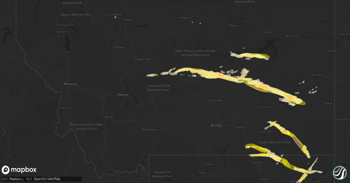
Hail Map in Montana on August 3, 2013
Get this storm
August 3 map
$229
one time, instant access
Download today. No call, no setup
Keep the $229
Bought the map and want the full workflow? Apply the entire $229 to a subscription within 7 days. None of it is wasted.
Every map, not just this one
This buys you this map. Subscription and you get every map we run, in the markets you choose from a few cities to whole states to nationwide. Plus real-time alerts the moment a storm fires.
Contact data
Name, contact info, occupancy, even credit band for addresses in the footprint. You go from where it hit to who to call.
Become the source they trust
Unlimited branding weather history reports on demand. You already have the documented answer ready for the property owner, and you are the one who showed up with it.
Property data and RoofTrace estimates
Pull up any address you have got, its value and the exact code rules for that jurisdiction, straight from One Click Code. Then RoofTrace estimates the squares, pitch, and roof value, priced the way you price.
Storm reports in Montana
Montana
| Date | Description |
|---|---|
| 08/03/20136:30 PM CDT | A local report indicates 1.25 inch wind near HELL CREEK RECREATION A |
| 08/03/20136:30 PM CDT | Estimated 50 to 60 mph wind gust. |
| 08/03/20136:20 PM CDT | Received 1.10 inches of rain in 10 minutes. |
| 08/03/20136:15 PM CDT | Also estimated 50 mph winds |
| 08/03/20135:55 PM CDT | A local report indicates 2.00 inch wind near 9 N BRUSETT |
| 08/03/20135:55 PM CDT | A local report indicates 2.50 inch wind near 10 N BRUSETT |
| 08/03/20135:40 PM CDT | Had 5 windows and all skylights broken in home by the hail along with 0.62 inches of rain |
| 08/03/20135:14 PM CDT | A local report indicates 1.25 inch wind near GRASS RANGE |
| 08/03/20134:10 PM CDT | Winds estimated around 60 mph with thunderstorm. 0.20-0.30 rainfall estimated. |
| 08/03/20132:48 PM CDT | 1 inch hail in stanford. Ground is white. |
| 08/03/20132:45 PM CDT | 64 mph wind gust and one half inch hail south of stanford. |
| 08/03/20132:34 PM CDT | A local report indicates 1.00 inch wind near 1 SSE MONARCH |
| 08/02/201311:00 PM CDT | A local report indicates 1.00 inch wind near 12 E MOORHEAD |
| 08/02/20139:35 PM CDT | A local report indicates 60 MPH wind near 8 NNW MARSH |
| 08/02/20139:30 PM CDT | A local report indicates 1.25 inch wind near 1 S TUSLER |
| 08/02/20139:30 PM CDT | A local report indicates 1.75 inch wind near 3 E TUSLER |
| 08/02/20138:59 PM CDT | A local report indicates 2.50 inch wind near 10 N BIDDLE |
| 08/02/20138:59 PM CDT | A local report indicates 65 MPH wind near 10 N BIDDLE |
| 08/02/20138:55 PM CDT | Brief touchdown rural area |
| 08/02/20138:35 PM CDT | A local report indicates 1.50 inch wind near 9 S BROADUS |
| 08/02/20138:30 PM CDT | A local report indicates 1.00 inch wind near 20 NW MILES CITY |
| 08/02/20138:20 PM CDT | A local report indicates 4.25 inch wind near 5 SSW BROADUS |
| 08/02/20138:15 PM CDT | Brief touchdown |
| 08/02/20138:13 PM CDT | A local report indicates 1.75 inch wind near 4 SSW OLIVE |
| 08/02/20137:57 PM CDT | A local report indicates 1.75 inch wind near 10 S STACEY |
| 08/02/20137:35 PM CDT | A local report indicates 1.00 inch wind near 7 NNE DECKER |
| 08/02/20137:20 PM CDT | Heavy rain |
| 08/02/20137:15 PM CDT | A local report indicates 1.00 inch wind near 5 N TONGUE RIVER RESERV |
| 08/02/20137:15 PM CDT | A local report indicates 60 MPH wind near 5 N TONGUE RIVER RESERV |
| 08/02/20137:15 PM CDT | A local report indicates 1.25 inch wind near 3 SE STACEY |
| 08/02/20137:10 PM CDT | A local report indicates 60 MPH wind near 11 SW NELSON CREEK RECR |
All States Impacted by Hail Map on August 3, 2013
Cities Impacted by Hail Map on August 3, 2013
- Valentine, NE
- Decker, MT
- Lafayette, CO
- Broomfield, CO
- Boulder, CO
- Brighton, CO
- Erie, CO
- Nara Visa, NM
- Fort Peck, MT
- Nashua, MT
- Folsom, NM
- Carr, CO
- Fort Collins, CO
- Wellington, CO
- Nunn, CO
- Longmont, CO
- La Salle, CO
- Gillette, WY
- Cheyenne, WY
- Lodge Grass, MT
- Dalhart, TX
- Lewistown, MT
- Denton, MT
- Jordan, MT
- Monarch, MT
- Otter, MT
- Sheridan Lake, CO
- Winnett, MT
- Olive, MT
- Broadus, MT
- Forsyth, MT
- Pierce, CO
- Ault, CO
- Wheatland, WY
- Laramie, WY
- Grenville, NM
- Volborg, MT
- Mosquero, NM
- Clearmont, WY
- Sundance, WY
- Hulett, WY
- Weston, WY
- Devils Tower, WY
- Moorcroft, WY
- Rozet, WY
- Lucerne, CO
- Timnath, CO
- Evans, CO
- Livermore, CO
- Kersey, CO
- Greeley, CO
- Eaton, CO
- Milliken, CO
- Windsor, CO
- Fort Morgan, CO
- Roy, NM
- Sheridan, WY
- Vega, TX
- Sand Springs, MT
- Brusett, MT
- Clayton, NM
- Cody, NE
- Merriman, NE
- Matheson, CO
- Ramah, CO
- Simla, CO
- Kinsey, MT
- Angela, MT
- Miles City, MT
- Ismay, MT
- Garden City, KS
- Kaycee, WY
- Douglas, WY
- Datil, NM
- Granite Canon, WY
- Glenrock, WY
- Perryton, TX
- Miami, TX
- Sharon, TN
- Dresden, TN
- Eads, CO
- Spearville, KS
- Jetmore, KS
- Hanston, KS
- Zortman, MT
- Boise City, OK
- Accomac, VA
- Onancock, VA
- Onley, VA
- Grass Range, MT
- Hilger, MT
- Mosby, MT
- Roy, MT
- Stanford, MT
- Chesapeake, VA
- Colorado Springs, CO
- Wyola, MT
- Ranchester, WY
- Amistad, NM
- Agate, CO
- Limon, CO
- Chinook, MT
- Garrett, WY
- Greenbush, VA
- Parksley, VA
- Melfa, VA
- Greensboro, AL
- Cohagen, MT
- Genoa, CO
- Woodrow, CO
- Platteville, CO
- Johnstown, CO
- Linden, NC
- Burrton, KS
- Dodge City, KS
- Deer Trail, CO
- Grimesland, NC
- Greenville, NC
- Pueblo, CO
- Geyser, MT
- Henderson, NC
- Dendron, VA
- Waverly, VA
- Spring Grove, VA
- Snyder, CO
- Alzada, MT
- Minneola, KS
- Casper, WY
- Neihart, MT
- Amarillo, TX
- Smithfield, VA
- Norfolk, VA
- Lakeside, AZ
- Durham, NC
- Warfield, VA
- Terry, MT
- Branson, CO
- Lyons, CO
- Arvada, WY
- Mount Olive, NC
- Albertson, NC
- Corolla, NC
- Kill Devil Hills, NC
- Kitty Hawk, NC
- Wakefield, VA
- Birney, MT
- Glendive, MT
- Barco, NC
- Trinidad, CO
- Trinchera, CO
- San Jon, NM
- Berthoud, CO
- Pampa, TX
- Parkman, WY
- Cut Bank, MT
- Ingalls, KS
- Cimarron, KS
- Moccasin, MT
- Manson, NC
- Texline, TX
- Brush, CO
- Malta, MT
- Channing, TX
- Des Moines, NM
- Gates, NC
- Yorktown, VA
- Midwest, WY
- Coffee Creek, MT
- Ivor, VA
- Disputanta, VA
- Elberon, VA
- Surry, VA
- Cary, NC
- Fallon, MT
- Stockett, MT
- Knotts Island, NC
- Virginia Beach, VA
- Chocowinity, NC
- Washington, NC
- Sedan, NM
- Ford, KS
- Loveland, CO
- Vale, SD
- Sturgis, SD
- Williamsburg, VA
- Toano, VA
- Houlton, ME
- Recluse, WY
- Rosebud, MT


