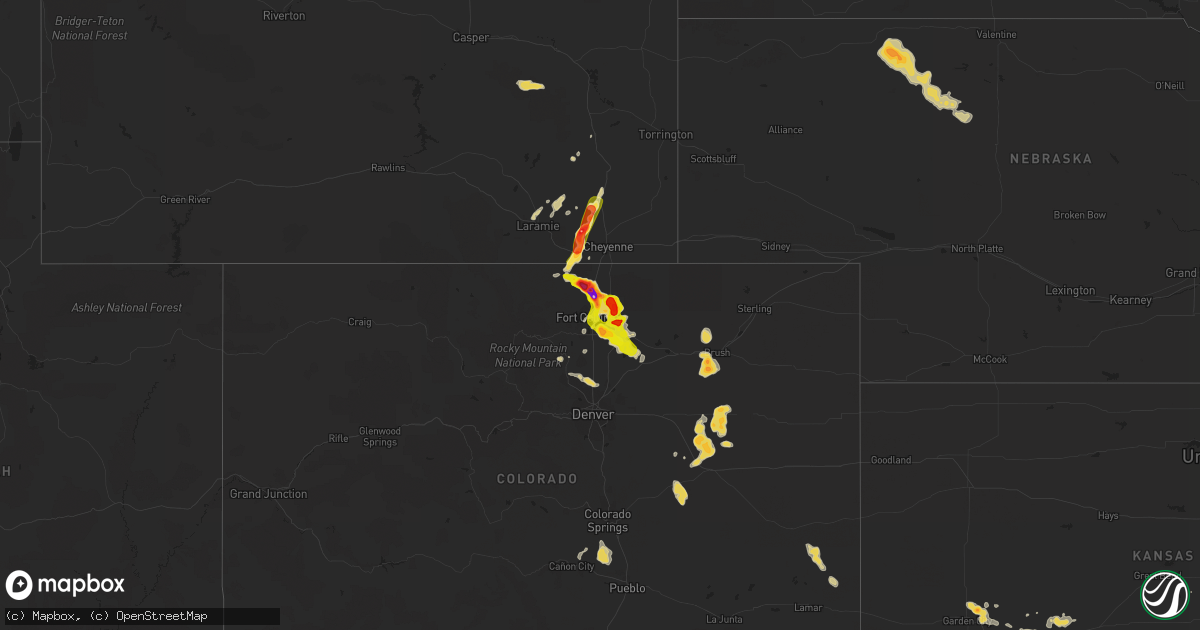
Hail Map on August 3, 2013
Get this storm
August 3 map
$229
one time, instant access
Download today. No call, no setup
Keep the $229
Bought the map and want the full workflow? Apply the entire $229 to a subscription within 7 days. None of it is wasted.
Every map, not just this one
This buys you this map. Subscription and you get every map we run, in the markets you choose from a few cities to whole states to nationwide. Plus real-time alerts the moment a storm fires.
Contact data
Name, contact info, occupancy, even credit band for addresses in the footprint. You go from where it hit to who to call.
Become the source they trust
Unlimited branding weather history reports on demand. You already have the documented answer ready for the property owner, and you are the one who showed up with it.
Property data and RoofTrace estimates
Pull up any address you have got, its value and the exact code rules for that jurisdiction, straight from One Click Code. Then RoofTrace estimates the squares, pitch, and roof value, priced the way you price.
States Impacted by Hail Map on August 3, 2013
Storm reports
Virginia
| Date | Description |
|---|---|
| 08/03/20132:25 PM CDT | A local report indicates 1.00 inch wind near TASLEY |
Florida
| Date | Description |
|---|---|
| 08/03/20134:55 PM CDT | Flagler county emergency management relayed a public report of trees downed by thunderstorm wind gusts along state road 11 near the flagler/volusia county line. Time of |
Nebraska
| Date | Description |
|---|---|
| 08/03/20139:20 AM CDT | Pea to marble size hail was also reported. |
| 08/03/20137:20 AM CDT | Wind driven hail knocked windows out and damaged part of a pasture. Size of hail is unknown. Time is estimated by radar. |
Wyoming
| Date | Description |
|---|---|
| 08/03/20134:39 PM CDT | A local report indicates 1.25 inch wind near 2 ESE FEDERAL |
| 08/03/20134:30 PM CDT | A local report indicates 2.75 inch wind near 1 NW FEDERAL |
| 08/03/20134:10 PM CDT | Hail between one inch and golf ball fell at this location. |
| 08/03/20134:10 PM CDT | Hail was accompaned by 70 mph winds. The wind driven hail broke windows and skylights. |
| 08/03/20134:10 PM CDT | Some just a bit smaller than a ping pong ball |
| 08/03/20134:08 PM CDT | Hail fell at mile marker 13 on horse creek road. |
| 08/03/20133:33 PM CDT | A local report indicates 1.50 inch wind near 19 W CHEYENNE |
| 08/02/201311:40 PM CDT | A local report indicates 1.00 inch wind near 1 SSE DEVILS TOWER |
| 08/02/201310:50 PM CDT | A local report indicates 1.00 inch wind near 17 N RECLUSE |
| 08/02/201310:45 PM CDT | Damaged alfalfa crop |
| 08/02/201310:30 PM CDT | Broken tree limbs of 6-8 inches around |
| 08/02/20139:46 PM CDT | Estimated 40-50 mph wind accompanied the hail. |
| 08/02/20139:19 PM CDT | Heavy rain and pea size hail accompanied the wind. |
| 08/02/20139:10 PM CDT | Pea size hail accompanied the wind. |
| 08/02/20139:05 PM CDT | A local report indicates 1.25 inch wind near 4 WSW OSHOTO |
| 08/02/20138:38 PM CDT | A local report indicates 1.75 inch wind near 11 NNW ROZET |
| 08/02/20138:20 PM CDT | A local report indicates 1.00 inch wind near 9 N LEITER |
| 08/02/20137:44 PM CDT | Some larger. Broke windows. |
| 08/02/20137:15 PM CDT | A local report indicates 1.75 inch wind near 3 SSE DECKER |
North Carolina
| Date | Description |
|---|---|
| 08/03/20136:20 PM CDT | One tree down at donaldson drive and hamilton court |
| 08/03/20136:19 PM CDT | 1 tree was blown down in the road on east cedar street. |
| 08/03/20135:15 PM CDT | A tree fell on a power line and caught fire |
Colorado
| Date | Description |
|---|---|
| 08/03/20136:55 PM CDT | A local report indicates 68 MPH wind near ERIE |
| 08/03/20136:53 PM CDT | 3 sections of wooden fence blown down...parts of siding torn...and other exterior damage. |
| 08/03/20136:47 PM CDT | A local report indicates 65 MPH wind near 1 S ERIE |
| 08/03/20136:24 PM CDT | Brief touchdown in open field with no damage reported |
| 08/03/20136:03 PM CDT | 12 inch diameter tree branches snapped |
| 08/03/20135:53 PM CDT | A local report indicates 1.00 inch wind near 1 W GREELEY |
| 08/03/20135:48 PM CDT | A local report indicates 1.00 inch wind near 4 W GREELEY |
| 08/03/20135:43 PM CDT | Street and sidewalk flooding. |
| 08/03/20135:30 PM CDT | A local report indicates 1.00 inch wind near 4 ENE EATON |
| 08/03/20135:29 PM CDT | Brief touchdown with no damage reported. |
| 08/03/20135:25 PM CDT | A local report indicates 1.00 inch wind near 6 E FORT COLLINS |
| 08/03/20135:21 PM CDT | A local report indicates 1.00 inch wind near 1 SSE WINDSOR |
| 08/03/20135:17 PM CDT | Brief touchdown with no damage reported |
| 08/03/20135:16 PM CDT | A local report indicates 1.75 inch wind near 3 S WINDSOR |
| 08/03/20135:07 PM CDT | Brief tornado in open field with no damage reported. |
| 08/03/20134:41 PM CDT | A local report indicates 1.75 inch wind near 1 NW AULT |
| 08/03/20134:37 PM CDT | Short duration tornado in open field with no damage reported. |
| 08/03/20134:21 PM CDT | A local report indicates 1.25 inch wind near 5 SE WELLINGTON |
| 08/03/20134:21 PM CDT | A local report indicates 1.50 inch wind near WELLINGTON |
| 08/03/20134:20 PM CDT | A local report indicates 1.75 inch wind near 2 W PIERCE |
| 08/03/20134:17 PM CDT | A local report indicates 1.75 inch wind near 1 E WELLINGTON |
| 08/03/20134:07 PM CDT | A local report indicates 2.75 inch wind near 3 NE WELLINGTON |
| 08/03/20133:55 PM CDT | Windshield broken |
| 08/03/20133:45 PM CDT | Shredded leaves...car dents...damaged shingles and broken house windows. Majority of stones were not spherical...more like the shape of rocks one digs out of the ground |
| 08/03/20133:32 PM CDT | Lasted 5 minutes |
| 08/03/20133:03 PM CDT | Short lived tornado in open field with no reports of damage. |
| 08/03/20133:02 PM CDT | Brief tornado in open field. On ground for 1-2min with no damage reported. |
| 08/02/20138:55 PM CDT | A local report indicates 61 MPH wind near BUCKLEY AFB |
| 08/02/20137:09 PM CDT | A local report indicates 60 MPH wind near 4 ESE ERIE |
| 08/02/20137:09 PM CDT | A local report indicates 60 MPH wind near 5 E LAFAYETTE |
Montana
| Date | Description |
|---|---|
| 08/03/20136:30 PM CDT | Estimated 50 to 60 mph wind gust. |
| 08/03/20136:30 PM CDT | A local report indicates 1.25 inch wind near HELL CREEK RECREATION A |
| 08/03/20136:20 PM CDT | Received 1.10 inches of rain in 10 minutes. |
| 08/03/20136:15 PM CDT | Also estimated 50 mph winds |
| 08/03/20135:55 PM CDT | A local report indicates 2.00 inch wind near 9 N BRUSETT |
| 08/03/20135:55 PM CDT | A local report indicates 2.50 inch wind near 10 N BRUSETT |
| 08/03/20135:40 PM CDT | Had 5 windows and all skylights broken in home by the hail along with 0.62 inches of rain |
| 08/03/20135:14 PM CDT | A local report indicates 1.25 inch wind near GRASS RANGE |
| 08/03/20134:10 PM CDT | Winds estimated around 60 mph with thunderstorm. 0.20-0.30 rainfall estimated. |
| 08/03/20132:48 PM CDT | 1 inch hail in stanford. Ground is white. |
| 08/03/20132:45 PM CDT | 64 mph wind gust and one half inch hail south of stanford. |
| 08/03/20132:34 PM CDT | A local report indicates 1.00 inch wind near 1 SSE MONARCH |
| 08/02/201311:00 PM CDT | A local report indicates 1.00 inch wind near 12 E MOORHEAD |
| 08/02/20139:35 PM CDT | A local report indicates 60 MPH wind near 8 NNW MARSH |
| 08/02/20139:30 PM CDT | A local report indicates 1.75 inch wind near 3 E TUSLER |
| 08/02/20139:30 PM CDT | A local report indicates 1.25 inch wind near 1 S TUSLER |
| 08/02/20138:59 PM CDT | A local report indicates 2.50 inch wind near 10 N BIDDLE |
| 08/02/20138:59 PM CDT | A local report indicates 65 MPH wind near 10 N BIDDLE |
| 08/02/20138:55 PM CDT | Brief touchdown rural area |
| 08/02/20138:35 PM CDT | A local report indicates 1.50 inch wind near 9 S BROADUS |
| 08/02/20138:30 PM CDT | A local report indicates 1.00 inch wind near 20 NW MILES CITY |
| 08/02/20138:20 PM CDT | A local report indicates 4.25 inch wind near 5 SSW BROADUS |
| 08/02/20138:15 PM CDT | Brief touchdown |
| 08/02/20138:13 PM CDT | A local report indicates 1.75 inch wind near 4 SSW OLIVE |
| 08/02/20137:57 PM CDT | A local report indicates 1.75 inch wind near 10 S STACEY |
| 08/02/20137:35 PM CDT | A local report indicates 1.00 inch wind near 7 NNE DECKER |
| 08/02/20137:20 PM CDT | Heavy rain |
| 08/02/20137:15 PM CDT | A local report indicates 60 MPH wind near 5 N TONGUE RIVER RESERV |
| 08/02/20137:15 PM CDT | A local report indicates 1.25 inch wind near 3 SE STACEY |
| 08/02/20137:15 PM CDT | A local report indicates 1.00 inch wind near 5 N TONGUE RIVER RESERV |
| 08/02/20137:10 PM CDT | A local report indicates 60 MPH wind near 11 SW NELSON CREEK RECR |
Cities Impacted by Hail Map on August 3, 2013
- Valentine, NE
- Decker, MT
- Lafayette, CO
- Broomfield, CO
- Boulder, CO
- Brighton, CO
- Erie, CO
- Nara Visa, NM
- Fort Peck, MT
- Nashua, MT
- Folsom, NM
- Carr, CO
- Fort Collins, CO
- Wellington, CO
- Nunn, CO
- Longmont, CO
- La Salle, CO
- Gillette, WY
- Cheyenne, WY
- Lodge Grass, MT
- Dalhart, TX
- Lewistown, MT
- Denton, MT
- Jordan, MT
- Monarch, MT
- Otter, MT
- Sheridan Lake, CO
- Winnett, MT
- Olive, MT
- Broadus, MT
- Forsyth, MT
- Pierce, CO
- Ault, CO
- Wheatland, WY
- Laramie, WY
- Grenville, NM
- Volborg, MT
- Mosquero, NM
- Clearmont, WY
- Sundance, WY
- Hulett, WY
- Weston, WY
- Devils Tower, WY
- Moorcroft, WY
- Rozet, WY
- Lucerne, CO
- Timnath, CO
- Evans, CO
- Livermore, CO
- Kersey, CO
- Greeley, CO
- Eaton, CO
- Milliken, CO
- Windsor, CO
- Fort Morgan, CO
- Roy, NM
- Sheridan, WY
- Vega, TX
- Sand Springs, MT
- Brusett, MT
- Clayton, NM
- Cody, NE
- Merriman, NE
- Matheson, CO
- Ramah, CO
- Simla, CO
- Kinsey, MT
- Angela, MT
- Miles City, MT
- Ismay, MT
- Garden City, KS
- Kaycee, WY
- Douglas, WY
- Datil, NM
- Granite Canon, WY
- Glenrock, WY
- Perryton, TX
- Miami, TX
- Sharon, TN
- Dresden, TN
- Eads, CO
- Spearville, KS
- Jetmore, KS
- Hanston, KS
- Zortman, MT
- Boise City, OK
- Accomac, VA
- Onancock, VA
- Onley, VA
- Grass Range, MT
- Hilger, MT
- Mosby, MT
- Roy, MT
- Stanford, MT
- Chesapeake, VA
- Colorado Springs, CO
- Wyola, MT
- Ranchester, WY
- Amistad, NM
- Agate, CO
- Limon, CO
- Chinook, MT
- Garrett, WY
- Greenbush, VA
- Parksley, VA
- Melfa, VA
- Greensboro, AL
- Cohagen, MT
- Genoa, CO
- Woodrow, CO
- Platteville, CO
- Johnstown, CO
- Linden, NC
- Burrton, KS
- Dodge City, KS
- Deer Trail, CO
- Grimesland, NC
- Greenville, NC
- Pueblo, CO
- Geyser, MT
- Henderson, NC
- Dendron, VA
- Waverly, VA
- Spring Grove, VA
- Snyder, CO
- Alzada, MT
- Minneola, KS
- Casper, WY
- Neihart, MT
- Amarillo, TX
- Smithfield, VA
- Norfolk, VA
- Lakeside, AZ
- Durham, NC
- Warfield, VA
- Terry, MT
- Branson, CO
- Lyons, CO
- Arvada, WY
- Mount Olive, NC
- Albertson, NC
- Corolla, NC
- Kill Devil Hills, NC
- Kitty Hawk, NC
- Wakefield, VA
- Birney, MT
- Glendive, MT
- Barco, NC
- Trinidad, CO
- Trinchera, CO
- San Jon, NM
- Berthoud, CO
- Pampa, TX
- Parkman, WY
- Cut Bank, MT
- Ingalls, KS
- Cimarron, KS
- Moccasin, MT
- Manson, NC
- Texline, TX
- Brush, CO
- Malta, MT
- Channing, TX
- Des Moines, NM
- Gates, NC
- Yorktown, VA
- Midwest, WY
- Coffee Creek, MT
- Ivor, VA
- Disputanta, VA
- Elberon, VA
- Surry, VA
- Cary, NC
- Fallon, MT
- Stockett, MT
- Knotts Island, NC
- Virginia Beach, VA
- Chocowinity, NC
- Washington, NC
- Sedan, NM
- Ford, KS
- Loveland, CO
- Vale, SD
- Sturgis, SD
- Williamsburg, VA
- Toano, VA
- Houlton, ME
- Recluse, WY
- Rosebud, MT