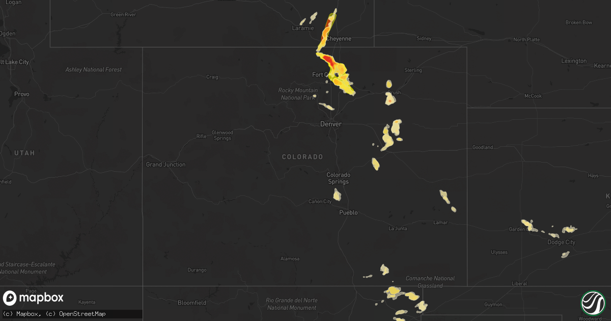
Hail Map in Colorado on August 3, 2013
Get this storm
August 3 map
$229
one time, instant access
Download today. No call, no setup
Keep the $229
Bought the map and want the full workflow? Apply the entire $229 to a subscription within 7 days. None of it is wasted.
Every map, not just this one
This buys you this map. Subscription and you get every map we run, in the markets you choose from a few cities to whole states to nationwide. Plus real-time alerts the moment a storm fires.
Contact data
Name, contact info, occupancy, even credit band for addresses in the footprint. You go from where it hit to who to call.
Become the source they trust
Unlimited branding weather history reports on demand. You already have the documented answer ready for the property owner, and you are the one who showed up with it.
Property data and RoofTrace estimates
Pull up any address you have got, its value and the exact code rules for that jurisdiction, straight from One Click Code. Then RoofTrace estimates the squares, pitch, and roof value, priced the way you price.
Storm reports in Colorado
Colorado
| Date | Description |
|---|---|
| 08/03/20136:55 PM CDT | A local report indicates 68 MPH wind near ERIE |
| 08/03/20136:53 PM CDT | 3 sections of wooden fence blown down...parts of siding torn...and other exterior damage. |
| 08/03/20136:47 PM CDT | A local report indicates 65 MPH wind near 1 S ERIE |
| 08/03/20136:24 PM CDT | Brief touchdown in open field with no damage reported |
| 08/03/20136:03 PM CDT | 12 inch diameter tree branches snapped |
| 08/03/20135:53 PM CDT | A local report indicates 1.00 inch wind near 1 W GREELEY |
| 08/03/20135:48 PM CDT | A local report indicates 1.00 inch wind near 4 W GREELEY |
| 08/03/20135:43 PM CDT | Street and sidewalk flooding. |
| 08/03/20135:30 PM CDT | A local report indicates 1.00 inch wind near 4 ENE EATON |
| 08/03/20135:29 PM CDT | Brief touchdown with no damage reported. |
| 08/03/20135:25 PM CDT | A local report indicates 1.00 inch wind near 6 E FORT COLLINS |
| 08/03/20135:21 PM CDT | A local report indicates 1.00 inch wind near 1 SSE WINDSOR |
| 08/03/20135:17 PM CDT | Brief touchdown with no damage reported |
| 08/03/20135:16 PM CDT | A local report indicates 1.75 inch wind near 3 S WINDSOR |
| 08/03/20135:07 PM CDT | Brief tornado in open field with no damage reported. |
| 08/03/20134:41 PM CDT | A local report indicates 1.75 inch wind near 1 NW AULT |
| 08/03/20134:37 PM CDT | Short duration tornado in open field with no damage reported. |
| 08/03/20134:21 PM CDT | A local report indicates 1.50 inch wind near WELLINGTON |
| 08/03/20134:21 PM CDT | A local report indicates 1.25 inch wind near 5 SE WELLINGTON |
| 08/03/20134:20 PM CDT | A local report indicates 1.75 inch wind near 2 W PIERCE |
| 08/03/20134:17 PM CDT | A local report indicates 1.75 inch wind near 1 E WELLINGTON |
| 08/03/20134:07 PM CDT | A local report indicates 2.75 inch wind near 3 NE WELLINGTON |
| 08/03/20133:55 PM CDT | Windshield broken |
| 08/03/20133:45 PM CDT | Shredded leaves...car dents...damaged shingles and broken house windows. Majority of stones were not spherical...more like the shape of rocks one digs out of the ground |
| 08/03/20133:32 PM CDT | Lasted 5 minutes |
| 08/03/20133:03 PM CDT | Short lived tornado in open field with no reports of damage. |
| 08/03/20133:02 PM CDT | Brief tornado in open field. On ground for 1-2min with no damage reported. |
| 08/02/20138:55 PM CDT | A local report indicates 61 MPH wind near BUCKLEY AFB |
| 08/02/20137:09 PM CDT | A local report indicates 60 MPH wind near 5 E LAFAYETTE |
| 08/02/20137:09 PM CDT | A local report indicates 60 MPH wind near 4 ESE ERIE |
All States Impacted by Hail Map on August 3, 2013
Cities Impacted by Hail Map on August 3, 2013
- Valentine, NE
- Decker, MT
- Lafayette, CO
- Broomfield, CO
- Boulder, CO
- Brighton, CO
- Erie, CO
- Nara Visa, NM
- Fort Peck, MT
- Nashua, MT
- Folsom, NM
- Carr, CO
- Fort Collins, CO
- Wellington, CO
- Nunn, CO
- Longmont, CO
- La Salle, CO
- Gillette, WY
- Cheyenne, WY
- Lodge Grass, MT
- Dalhart, TX
- Lewistown, MT
- Denton, MT
- Jordan, MT
- Monarch, MT
- Otter, MT
- Sheridan Lake, CO
- Winnett, MT
- Olive, MT
- Broadus, MT
- Forsyth, MT
- Pierce, CO
- Ault, CO
- Wheatland, WY
- Laramie, WY
- Grenville, NM
- Volborg, MT
- Mosquero, NM
- Clearmont, WY
- Sundance, WY
- Hulett, WY
- Weston, WY
- Devils Tower, WY
- Moorcroft, WY
- Rozet, WY
- Lucerne, CO
- Timnath, CO
- Evans, CO
- Livermore, CO
- Kersey, CO
- Greeley, CO
- Eaton, CO
- Milliken, CO
- Windsor, CO
- Fort Morgan, CO
- Roy, NM
- Sheridan, WY
- Vega, TX
- Sand Springs, MT
- Brusett, MT
- Clayton, NM
- Cody, NE
- Merriman, NE
- Matheson, CO
- Ramah, CO
- Simla, CO
- Kinsey, MT
- Angela, MT
- Miles City, MT
- Ismay, MT
- Garden City, KS
- Kaycee, WY
- Douglas, WY
- Datil, NM
- Granite Canon, WY
- Glenrock, WY
- Perryton, TX
- Miami, TX
- Sharon, TN
- Dresden, TN
- Eads, CO
- Spearville, KS
- Jetmore, KS
- Hanston, KS
- Zortman, MT
- Boise City, OK
- Accomac, VA
- Onancock, VA
- Onley, VA
- Grass Range, MT
- Hilger, MT
- Mosby, MT
- Roy, MT
- Stanford, MT
- Chesapeake, VA
- Colorado Springs, CO
- Wyola, MT
- Ranchester, WY
- Amistad, NM
- Agate, CO
- Limon, CO
- Chinook, MT
- Garrett, WY
- Greenbush, VA
- Parksley, VA
- Melfa, VA
- Greensboro, AL
- Cohagen, MT
- Genoa, CO
- Woodrow, CO
- Platteville, CO
- Johnstown, CO
- Linden, NC
- Burrton, KS
- Dodge City, KS
- Deer Trail, CO
- Grimesland, NC
- Greenville, NC
- Pueblo, CO
- Geyser, MT
- Henderson, NC
- Dendron, VA
- Waverly, VA
- Spring Grove, VA
- Snyder, CO
- Alzada, MT
- Minneola, KS
- Casper, WY
- Neihart, MT
- Amarillo, TX
- Smithfield, VA
- Norfolk, VA
- Lakeside, AZ
- Durham, NC
- Warfield, VA
- Terry, MT
- Branson, CO
- Lyons, CO
- Arvada, WY
- Mount Olive, NC
- Albertson, NC
- Corolla, NC
- Kill Devil Hills, NC
- Kitty Hawk, NC
- Wakefield, VA
- Birney, MT
- Glendive, MT
- Barco, NC
- Trinidad, CO
- Trinchera, CO
- San Jon, NM
- Berthoud, CO
- Pampa, TX
- Parkman, WY
- Cut Bank, MT
- Ingalls, KS
- Cimarron, KS
- Moccasin, MT
- Manson, NC
- Texline, TX
- Brush, CO
- Malta, MT
- Channing, TX
- Des Moines, NM
- Gates, NC
- Yorktown, VA
- Midwest, WY
- Coffee Creek, MT
- Ivor, VA
- Disputanta, VA
- Elberon, VA
- Surry, VA
- Cary, NC
- Fallon, MT
- Stockett, MT
- Knotts Island, NC
- Virginia Beach, VA
- Chocowinity, NC
- Washington, NC
- Sedan, NM
- Ford, KS
- Loveland, CO
- Vale, SD
- Sturgis, SD
- Williamsburg, VA
- Toano, VA
- Houlton, ME
- Recluse, WY
- Rosebud, MT


