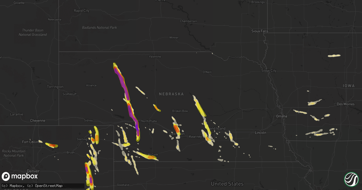
Hail Map in Nebraska on August 2, 2017
Get this storm
August 2 map
$229
one time, instant access
Download today. No call, no setup
Keep the $229
Bought the map and want the full workflow? Apply the entire $229 to a subscription within 7 days. None of it is wasted.
Every map, not just this one
This buys you this map. Subscription and you get every map we run, in the markets you choose from a few cities to whole states to nationwide. Plus real-time alerts the moment a storm fires.
Contact data
Name, contact info, occupancy, even credit band for addresses in the footprint. You go from where it hit to who to call.
Become the source they trust
Unlimited branding weather history reports on demand. You already have the documented answer ready for the property owner, and you are the one who showed up with it.
Property data and RoofTrace estimates
Pull up any address you have got, its value and the exact code rules for that jurisdiction, straight from One Click Code. Then RoofTrace estimates the squares, pitch, and roof value, priced the way you price.
Storm reports in Nebraska
Nebraska
| Date | Description |
|---|---|
| 08/02/20176:48 PM CDT | A local report indicates 1.75 inch wind near 6 N WALLACE |
| 08/02/20176:47 PM CDT | Storm chaser report baseball size hail |
| 08/02/20176:09 PM CDT | Golf to tennis ball hail |
| 08/02/20176:07 PM CDT | Relayed by paxton fire department... Golf ball size hail with 40 to 50 mph winds. Update... They also relayed damage from hail including holes in siding and cracked to |
| 08/02/20176:05 PM CDT | Corn crop stripped due to wind and hail |
| 08/02/20176:05 PM CDT | Via social media |
| 08/02/20175:56 PM CDT | Pea to golf ball size hail |
| 08/02/20175:49 PM CDT | Heavy rain and quarter size hail |
| 08/02/20175:19 PM CDT | 1.25 inch size hail and strong non-svr gusty winds |
| 08/02/20175:00 PM CDT | Brief large hail up to golf ball size and heavy rain. |
| 08/02/20171:00 AM CDT | Delayed report of an approximately 5 inch tree branch down. Estimated 50 to 60 mph gusts. |
| 08/02/201712:35 AM CDT | Delayed report: trained spotter reported estimated 60 mph wind gusts... And 3 inch tree branches down. |
| 08/02/201712:05 AM CDT | Public report via mping. |
| 08/02/201712:02 AM CDT | Trained spotter reports heavy rain... Estimated wind gusts at 60 mph... And hail to the size of quarters. |
| 08/01/201710:34 PM CDT | Law enforcement reports golf ball size hail and estimated 60 mph winds at the intersection of road 761 and hiway 21. |
| 08/01/20177:40 PM CDT | A local report indicates 76 MPH wind near IMPERIAL |
| 08/01/20177:40 PM CDT | Large tree snapped in half. |
| 08/01/20177:37 PM CDT | Co-op estimated winds north of imperial |
| 08/01/20177:36 PM CDT | A local report indicates 1.00 inch wind near 3 E TRENTON |
| 08/01/20177:36 PM CDT | A local report indicates 1.00 inch wind near TRENTON |
| 08/01/20177:31 PM CDT | A local report indicates 1.25 inch wind near TRENTON |
| 08/01/20177:20 PM CDT | A local report indicates 2.00 inch wind near 5 S WALLACE |
| 08/01/20177:01 PM CDT | Golf ball size hail exhibiting saucer shape |
All States Impacted by Hail Map on August 2, 2017
Cities Impacted by Hail Map on August 2, 2017
- Bondville, VT
- Eddyville, NE
- Lexington, NE
- Venango, NE
- Culbertson, NE
- Trenton, NE
- Clarks Summit, PA
- Rockholds, KY
- Williamsburg, KY
- Gothenburg, NE
- Cozad, NE
- Merriman, NE
- Gravity, IA
- Sharpsburg, IA
- Clarinda, IA
- New Market, IA
- Lenox, IA
- Gibbon, NE
- Shelton, NE
- Kenesaw, NE
- Ravenna, NE
- Cairo, NE
- Wood River, NE
- Doniphan, NE
- Ayr, NE
- Rockville, NE
- Juniata, NE
- Roseland, NE
- Hastings, NE
- Boelus, NE
- Fryeburg, ME
- Harrison, ME
- Fleming, CO
- Gill, CO
- Max, NE
- Imperial, NE
- Grant, NE
- Champion, NE
- Enders, NE
- Yuma, CO
- Madison, NH
- Haxtun, CO
- Peru, VT
- Quincy, CA
- Wild Horse, CO
- Flagler, CO
- Seibert, CO
- Eads, CO
- Kit Carson, CO
- Vona, CO
- Anton, CO
- Akron, CO
- Cope, CO
- Otis, CO
- Briggsdale, CO
- West Wardsboro, VT
- Jamaica, VT
- Stapleton, NE
- Kent, CT
- Sharon, CT
- New Milford, CT
- Cornwall, CT
- West Cornwall, CT
- Sherman, CT
- Cornwall Bridge, CT
- Goshen, CT
- South Kent, CT
- Gaylordsville, CT
- Litchfield, CT
- Contoocook, NH
- Crook, CO
- Chateaugay, NY
- Stratton, NE
- Atwood, KS
- McDonald, KS
- Madrid, NE
- Wauneta, NE
- Holyoke, CO
- Beulah, CO
- Williamsport, PA
- Cogan Station, PA
- Concord, NH
- Canterbury, NH
- Kersey, CO
- Exira, IA
- Oconto, NE
- Sebree, KY
- Devon, PA
- Wayne, PA
- Conshohocken, PA
- Villanova, PA
- King Of Prussia, PA
- Kingston, MO
- Polo, MO
- Cameron, MO
- Cross Plains, IN
- Dillsboro, IN
- Bennington, IN
- Effingham, NH
- Freedom, NH
- Porter, ME
- Parsonsfield, ME
- Yucca, AZ
- Olmstead, KY
- Russellville, KY
- Iliff, CO
- Wallace, NE
- Joes, CO
- Hamlin, IA
- Guthrie Center, IA
- Brayton, IA
- Adair, IA
- Atlantic, IA
- Walnut, IA
- Avoca, IA
- Lewis, IA
- Minden, IA
- Oakland, IA
- Hancock, IA
- Hyannis, NE
- Sutherland, NE
- Arthur, NE
- Paxton, NE
- Overton, NE
- Norristown, PA
- Blue Bell, PA
- Plymouth Meeting, PA
- Lovell, ME
- Orient, IA
- Greenfield, IA
- Winterset, IA
- Dearborn, MI
- Detroit, MI
- Cedar Grove, NJ
- Henderson, NE
- Grafton, NE
- Sutton, NE
- Thompson, MO
- Eagle Butte, SD
- Cheshire, CT
- Greentown, PA
- Hancock, NY
- Susquehanna, PA
- Starlight, PA
- Beech Creek, KY
- Drakesboro, KY
- Beechmont, KY
- Paris, KY
- Fort Gratiot, MI
- Wolcott, CT
- Hiram, ME
- Whitman, NE
- Hayes Center, NE
- Elk Creek, NE
- Tecumseh, NE
- Southington, CT
- Meriden, CT
- Edmonton, KY
- Ulster Park, NY
- Kingston, NY
- Cynthiana, KY
- Upper Darby, PA
- Drexel Hill, PA
- Andover, NY
- McCook, NE
- Frankfort, KY
- Valhalla, NY
- Hawthorne, NY
- Maywood, NE
- Wellfleet, NE
- Timber Lake, SD
- North Loup, NE
- Loup City, NE
- Ord, NE
- Ashton, NE
- Harrisburg, PA
- Anabel, MO
- Atlanta, MO
- Macon, MO
- Pine Valley, CA
- Thendara, NY
- Palisade, NE
- Renwick, IA
- Danbury, NE
- Glen Arm, MD
- Bridgewater, IA
- Shelbina, MO
- Clarence, MO
- Lentner, MO
- Stamping Ground, KY
- Sadieville, KY
- Geneva, NE
- Manning, IA
- Templeton, IA
- Sussex, NJ
- Unionville, NY
- Pine Island, NY
- New Hampton, NY
- Westtown, NY
- Aurora, NE
- Ohiowa, NE
- Thornwood, NY
- Chappaqua, NY
- Pleasantville, NY
- White Plains, NY
- Armonk, NY
- Elmsford, NY
- Fairfield, NE
- Deweese, NE
- Kingman, AZ
- Rosendale, NY
- Bovina Center, NY
- Fontanelle, IA
- Massena, IA
- Prescott, IA
- Elyria, NE
- Burwell, NE
- Mullen, NE
- Damascus, PA
- Hankins, NY
- Equinunk, PA
- Long Eddy, NY
- Fremont Center, NY
- Callicoon, NY
- Auxvasse, MO
- Fairbury, NE
- Olivebridge, NY
- Clayton, KS
- Lewisburg, KY
- Center Ossipee, NH
- Tamworth, NH
- Silver Lake, NH
- West Ossipee, NH
- Sterling, NE
- White Marsh, MD
- Hydes, MD
- Perry Hall, MD
- Parkville, MD
- Nottingham, MD
- Upper Falls, MD
- Kingsville, MD
- Perryville, MO
- Farmington, MO
- Denmark, ME
- Wellsville, NY
- Alfred Station, NY
- Hustontown, PA
- Huntington, NY
- Arcadia, NE
- Benkelman, NE
- Bird City, KS
- Diagonal, IA
- Bedford, IA
- Benton, IA
- Clearfield, IA
- Portola, CA
- Kanawha, IA
- Grand Island, NE
- Saint Libory, NE
- Bloomington, NY
- Lexington, MA
- Arlington, MA
- Winchester, MA
- Valley Center, CA
- Pauma Valley, CA
- Caldwell, NJ
- Roseland, NJ
- Pine Brook, NJ
- Livingston, NJ
- East Hanover, NJ
- Chapman, NE
- Shelbyville, IN
- Lakewood, PA
- Philadelphia, PA
- Londonderry, VT
- Shirleysburg, PA
- Mount Union, PA
- Elsie, NE
- Auburn, KY
- Madison, MO
- Holliday, MO
- Saint Clair, PA
- Walsenburg, CO
- Grand River, IA
- Murray, IA
- Ellston, IA
- Thayer, IA
- Chester, MA
- Blandford, MA
- Churubusco, NY
- McLaughlin, SD
- Erie, PA
- Waterford, PA
- Union City, PA
- Eaton, CO
- Ault, CO
- North Platte, NE
- Bolton, MA
- Acton, MA
- Concord, MA
- Maynard, MA
- Harvard, MA
- Sudbury, MA
- Stow, MA
- West Suffield, CT
- Suffield, CT
- Long Valley, NJ
- Mount Pleasant Mills, PA
- Richfield, PA
- Dover Plains, NY
- Cummington, MA
- Plainfield, MA
- Farragut, IA
- Shenandoah, IA
- Santa Ysabel, CA
- Goshen, NY
- Middletown, NY
- Campbell Hall, NY
- Sandy Hook, CT
- Southbury, CT
- Bel Air, MD
- Forest Hill, MD
- Agar, SD
- Gettysburg, SD
- New Boston, MO
- Elba, NE
- Shickley, NE
- Southgate, MI
- Amenia, NY
- Palomar Mountain, CA
- Warner Springs, CA
- Davison, MI
- Rineyville, KY
- Fairfax, SD
- Edinburgh, IN
- Hurley, NY
- Corwith, IA
- Lu Verne, IA
- Hardy, IA
- Bode, IA
- Livermore, IA
- Bertrand, NE
- Oxford, NE
- Edison, NE
- Pioneer, TN
- Taylorsville, CA
- Martinsburg, PA
- Saxton, PA
- Summer Shade, KY
- Blairstown, NJ
- Elwood, NE
- Onida, SD
- Pierre, SD
- Callaway, NE
- Spartansburg, PA
- Centerville, PA
- Coatesville, PA
- Bridgewater, CT
- Brookfield, CT
- Guys Mills, PA
- Union Star, KY
- Stephensport, KY
- Demarest, NJ
- Closter, NJ
- Haworth, NJ
- Dumont, NJ
- Alpine, NJ
- Medway, MA
- Franklin, MA
- Cumberland, IA
- Superior, NE
- Montgomery, PA
- New City, NY
- Wiggins, CO
- Bismarck, MO
- Ironton, MO
- Sedgwick, CO
- Carleton, MI
- Monroe, MI
- Ridgeview, SD
- Hummelstown, PA
- Long Lake, NY
- Slatersville, RI
- North Smithfield, RI
- Grand Blanc, MI
- Annville, PA
- Jennings, KS
- Orwell, OH
- North Bloomfield, OH
- Canton, CT
- West Granby, CT
- Owenton, KY
- Allen Park, MI
- Wyandotte, MI
- Romulus, MI
- Riverview, MI
- Trenton, MI
- Taylor, MI
- Lincoln Park, MI
- Cross Fork, PA
- New Kingston, NY
- Pocono Pines, PA
- Pocono Lake, PA
- Ogallala, NE
- Deposit, NY
- Storrs Mansfield, CT
- Saint Paul, NE
- Parks, NE
- East Dorset, VT
- Manchester Center, VT
- Dorset, VT
- Saronville, NE
- Harvard, NE
- Giltner, NE
- Wagner, SD
- South Newfane, VT
- Newfane, VT
- Port Trevorton, PA
- Fort Collins, CO
- New Boston, MI
- Wilmington, DE
- Swedesboro, NJ
- Bridgeport, NJ
- Mansfield Center, CT
- Bullhead City, AZ
- Elkins Park, PA
- Cheltenham, PA
- York, PA
- Honesdale, PA
- Hampton, NE
- Arnold, MD
- Mount Ayr, IA
- Kellerton, IA
- Tingley, IA
- Munden, KS
- Belleville, KS
- Browder, KY
- Belton, KY
- Glastonbury, CT
- East Hartford, CT
- Vernon Rockville, CT
- Manchester, CT
- Taylor, PA
- Scranton, PA
- West Hurley, NY
- New Liberty, KY
- Worthville, KY
- Boxborough, MA
- Bridgton, ME
- Lawrence, NE
- Truckee, CA
- Bethlehem, PA
- Allentown, PA
- Easton, PA
- Montgomery, NY
- New Windsor, NY
- Rock Tavern, NY
- Pleasant Mount, PA
- Cowgill, MO
- Greenville, CA
- Carlisle, KY
- Ashland, PA
- Chicopee, MA
- Seneca, NE
- Ashby, NE
- Bath, PA
- Nazareth, PA
- Auburn, PA
- Paterson, NJ
- Clifton, NJ
- Little Falls, NJ
- Wayne, NJ
- Totowa, NJ
- Fairfield, NJ
- Oakland, RI
- Mapleville, RI
- Harrisville, RI
- Falls Village, CT
- Lakeville, CT
- New Albany, PA
- Tobyhanna, PA
- Mexico, MO
- Hardy, NE
- Republic, KS
- Smithfield, NE
- Carbondale, IL
- Lapeer, MI
- Middle River, MD
- Shannon City, IA
- Feeding Hills, MA
- West Springfield, MA
- Hawley, PA
- Richmond, KY
- Pocono Summit, PA
- Eustis, NE
- Strang, NE
- Hardinsburg, KY
- West Shokan, NY
- Bernville, PA
- Weatherly, PA
- Farwell, NE
- Flint, MI
- Guide Rock, NE
- Pen Argyl, PA
- Wind Gap, PA
- Crescent Mills, CA
- Seneca Falls, NY
- Bronx, NY
- Blackstone, MA
- Mendon, MA
- Bellingham, MA
- Pottstown, PA
- Schwenksville, PA
- Hobart, NY
- Porter Corners, NY
- Corinth, NY
- Campbell, NY
- Savona, NY
- Bath, NY
- Gilbertville, MA
- New Braintree, MA
- Bangor, PA
- Mount Bethel, PA
- Mooers Forks, NY
- Barre, MA
- Shade Gap, PA
- Burnt Cabins, PA
- Cold Brook, NY
- Smiths Creek, MI
- North Street, MI
- Moores Hill, IN
- Aurora, IN
- Canaan, IN
- Quakertown, PA
- Corning, IA
- Medford, MA
- Yonkers, NY
- Tuckahoe, NY
- Scarsdale, NY
- Eastchester, NY
- Winchester, KY
- Florence, AL
- Vevay, IN
- Madison, IN
- Julesburg, CO
- Roggen, CO
- Hardwick, MA
- Phoenicia, NY
- Port Huron, MI
- Deerfield, OH
- Atwater, OH
- North Branch, MI
- Sterling, CO
- Palacios, TX
- Lewellen, NE
- Mooers, NY
- Ramona, CA
- North Brookfield, MA
- Oakham, MA
- Andreas, PA
- New Ringgold, PA
- Seven Valleys, PA
- York New Salem, PA
- Spring Grove, PA
- Hopedale, MA
- Upton, MA
- Milford, MA
- Cold Spring Harbor, NY
- Vail, AZ
- Joppa, MD
- Edgewood, MD
- Tahoe City, CA
- La Plata, MO
- Lincoln Park, NJ
- Fair Lawn, NJ
- Montclair, NJ
- Elmwood Park, NJ
- Saddle Brook, NJ
- Beech Creek, PA
- Lexington, KY
- Coventry, CT
- Andover, CT
- Goodells, MI
- Old Forge, PA
- Renovo, PA
- North Bend, PA
- Naper, NE
- Louisville, OH
- Pasadena, MD
- Tyler Hill, PA
- Roscoe, NY
- Hortonville, NY
- Middleburg, PA
- Paoli, PA
- Berwyn, PA
- Malvern, PA
- Orchard, CO
- Gordon, NE
- Arnold, NE
- Indianola, NE
- South Londonderry, VT
- Charlemont, MA


