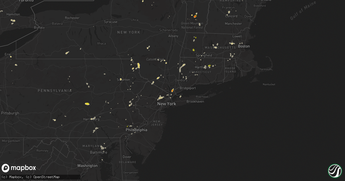
Hail Map on August 2, 2017
Get this storm
August 2 map
$229
one time, instant access
Download today. No call, no setup
Keep the $229
Bought the map and want the full workflow? Apply the entire $229 to a subscription within 7 days. None of it is wasted.
Every map, not just this one
This buys you this map. Subscription and you get every map we run, in the markets you choose from a few cities to whole states to nationwide. Plus real-time alerts the moment a storm fires.
Contact data
Name, contact info, occupancy, even credit band for addresses in the footprint. You go from where it hit to who to call.
Become the source they trust
Unlimited branding weather history reports on demand. You already have the documented answer ready for the property owner, and you are the one who showed up with it.
Property data and RoofTrace estimates
Pull up any address you have got, its value and the exact code rules for that jurisdiction, straight from One Click Code. Then RoofTrace estimates the squares, pitch, and roof value, priced the way you price.
States Impacted by Hail Map on August 2, 2017
Storm reports
Colorado
| Date | Description |
|---|---|
| 08/02/20176:45 PM CDT | Delayed social media report... Hail slightly larger than the size of quarters according to picture. |
| 08/02/20176:05 PM CDT | A local report indicates 2.00 inch wind near 5 E ARICKAREE SCHOOL |
| 08/02/20175:55 PM CDT | A local report indicates 1.00 inch wind near 2 ESE ARICKAREE SCHOOL |
| 08/02/20175:45 PM CDT | Extensive crop damage in vicinity of haxtun. Hail measured 3-4 inches deep over a widespread area. |
| 08/02/20175:15 PM CDT | A local report indicates 1.00 inch wind near OTIS |
| 08/02/20175:15 PM CDT | A local report indicates 1.25 inch wind near 10 E ELBA |
| 08/02/20175:14 PM CDT | A local report indicates 1.25 inch wind near 10 S FLEMING |
| 08/02/20175:06 PM CDT | A local report indicates 1.75 inch wind near 1 N ST PETERSBURG |
| 08/02/20175:00 PM CDT | A local report indicates 1.50 inch wind near 2 SSE OTIS |
| 08/02/20174:45 PM CDT | A local report indicates 1.00 inch wind near 5 S FLEMING |
| 08/02/20174:15 PM CDT | A local report indicates 1.00 inch wind near 6 ESE OTIS |
| 08/02/20173:21 PM CDT | Asos station ril... Rifle airport. |
| 08/01/20177:29 PM CDT | Hail was mostly quarters and ping pong ball sized and covered the ground. Wind measured at 54 mph before measuring device failed. Windows broken and tree branches down. |
| 08/01/20177:24 PM CDT | 2 limbs broken... 60 year old dead tree blown over |
Pennsylvania
| Date | Description |
|---|---|
| 08/02/20171:43 PM CDT | Trees and powerlines down |
| 08/02/20171:37 PM CDT | Large tree down across bald mountain rd |
| 08/02/20171:20 PM CDT | Tree down on road. |
| 08/02/20171:18 PM CDT | Trees and large branches down |
| 08/02/20171:11 PM CDT | Quarter-sized hail. |
| 08/02/20171:05 PM CDT | Tree down in haycock. Time estimated by radar. |
| 08/02/20171:05 PM CDT | Tree down in springfield. Time estimated by radar. |
| 08/02/20171:05 PM CDT | Tree down in bedminster. Time estimated by radar. |
| 08/02/201712:36 PM CDT | Trees down in perry twp |
| 08/02/201712:21 PM CDT | Trees/wires down in west perry twp |
| 08/02/201712:21 PM CDT | Trees/wires down in west perry twp |
| 08/01/20178:32 PM CDT | Trees and wires down |
Rhode Island
| Date | Description |
|---|---|
| 08/02/201712:35 PM CDT | Tree down on providence pike at industrial drive |
New York
| Date | Description |
|---|---|
| 08/02/20176:54 PM CDT | Trees and lines down at intersection of hemmingford rd. And north star rd. |
| 08/02/20176:13 PM CDT | Trees and lines down on patnode rd. At route 11 |
| 08/02/20172:41 PM CDT | Downed tree on ny17k westbound area of union street |
| 08/02/20171:50 PM CDT | Small trees down. Numerous tree limb downs. |
| 08/02/20171:45 PM CDT | Multiple trees down |
| 08/02/20171:12 PM CDT | Large branch split off a 20 foot tall tree |
| 08/02/20171:12 PM CDT | 20 inch decorative tree sheared off completely. |
| 08/02/20171:02 PM CDT | Trees and wires down. |
| 08/02/201712:56 PM CDT | Trees and wires down. |
| 08/02/201712:25 PM CDT | Trained spotter measured 1.75 inch hail golf ball sized |
| 08/02/201712:18 PM CDT | Tree limbs |
Michigan
| Date | Description |
|---|---|
| 08/02/20175:05 PM CDT | Multiple downed trees along west rd. Pictures shared on facebook. |
| 08/02/20174:22 PM CDT | Tree limbs down at belle isle state park. |
California
| Date | Description |
|---|---|
| 08/01/20179:50 PM CDT | Reports of golf ball size hail southeast of quincy in the vicinity of the minerva fire. |
Florida
| Date | Description |
|---|---|
| 08/02/20173:30 PM CDT | A tree was knocked down onto mcintosh road between proctor and ashton roads... Blocking one lane of traffic. |
Kansas
| Date | Description |
|---|---|
| 08/01/20178:40 PM CDT | Corn crop severely stripped by wind driven small hail that ranged in size from peas to dimes. Delayed report time estimated by radar. |
Kentucky
| Date | Description |
|---|---|
| 08/02/20174:15 PM CDT | Trees fell on the roofs of two houses. |
| 08/02/20172:27 PM CDT | Tree down at parkers mill road and versailles road. |
| 08/02/20171:48 PM CDT | Dispatch reported trees down on stepstone road... Ridge ave... Slate ave... And kendall springs road. Time estimated from radar. |
Connecticut
| Date | Description |
|---|---|
| 08/02/20173:07 PM CDT | Tree down on riverside ave |
| 08/02/20173:03 PM CDT | Route 341 and south kent road closed due to mutliple trees down and water across the road |
| 08/02/20173:03 PM CDT | Numerous trees and wires down along south kent road between spooner hill road and camps flat road |
| 08/02/20172:57 PM CDT | A local report indicates 1.00 inch wind near 1 NE GAYLORDSVILLE STAT |
| 08/02/20172:52 PM CDT | Tree down on wires on boulder road |
| 08/02/20172:45 PM CDT | Tree struck by lightning and caught fire. Radar estimated time. |
| 08/02/20172:15 PM CDT | Wires down on holiday drive |
| 08/02/20172:15 PM CDT | Tree down on power lines. |
| 08/02/20172:14 PM CDT | Tree down across roadway. |
| 08/02/20172:14 PM CDT | Tree down on power lines. |
| 08/02/20172:12 PM CDT | Trees and wires down. |
| 08/02/20171:12 PM CDT | Trained spotter |
| 08/02/201712:20 PM CDT | Trained spotter |
New Hampshire
| Date | Description |
|---|---|
| 08/02/20176:00 PM CDT | A local report indicates 1.00 inch wind near 3 S EATON |
| 08/02/20176:00 PM CDT | A local report indicates 1.00 inch wind near EATON |
| 08/02/20176:00 PM CDT | Trees down and marble sized hail |
| 08/02/20176:00 PM CDT | A local report indicates 1.75 inch wind near FREEDOM |
| 08/02/20176:00 PM CDT | Trees and wires downed all over town |
| 08/02/20174:00 PM CDT | Trees down |
Maryland
| Date | Description |
|---|---|
| 08/02/20176:11 PM CDT | Tree blown onto power lines. |
| 08/02/20173:01 PM CDT | Couple trees down at arbors apt complex |
| 08/02/20173:00 PM CDT | Chase elementary |
| 08/02/20172:21 PM CDT | Downed tree near joppa rd and philadelphia rd |
| 08/02/20172:13 PM CDT | Downed tree in the 12200 block of stoney batter rd |
| 08/02/20172:04 PM CDT | Tree down on hallhurst rd |
| 08/02/20171:56 PM CDT | Tree down 2400 blk telegraph rd |
| 08/02/20171:53 PM CDT | Wires down |
| 08/02/20171:48 PM CDT | Tree down across 2100 block of mt horeb rd |
| 08/02/20171:40 PM CDT | Tree down near harkins rd and onion rd |
| 08/02/201712:38 PM CDT | Tree on wires |
| 08/02/201712:04 PM CDT | Tree down |
| 08/02/201711:48 AM CDT | Tree with 6 inch diameter trunk down. |
| 08/01/20178:25 PM CDT | Tree blown onto power lines. |
New Jersey
| Date | Description |
|---|---|
| 08/02/20174:19 PM CDT | Wires down near vineland. Time estimated by radar. |
| 08/02/20173:29 PM CDT | Several trees down. |
| 08/02/20173:07 PM CDT | Large tree branches snapped in johnson park |
| 08/02/20173:05 PM CDT | Large branches down. |
| 08/02/20172:14 PM CDT | Trees down near jackson. Time estimated by radar. |
| 08/02/201712:25 PM CDT | Trees down at martha road and parkwary street |
| 08/02/201711:42 AM CDT | Tree branches and power lines down |
West Virginia
| Date | Description |
|---|---|
| 08/02/20176:45 PM CDT | Mping report of 1 inch branches broken and some shingles blown off roof. |
Vermont
| Date | Description |
|---|---|
| 08/02/20173:01 PM CDT | Golfball size hail. Several trees down. |
Nevada
| Date | Description |
|---|---|
| 08/01/20178:44 PM CDT | Site lxvgs. |
Ohio
| Date | Description |
|---|---|
| 08/02/20171:43 PM CDT | Trees and utility lines downed route 86 and 534. |
Alabama
| Date | Description |
|---|---|
| 08/02/20174:10 PM CDT | A tree was knocked down. |
| 08/02/20174:10 PM CDT | Large tree branch down on a car. |
| 08/02/20174:10 PM CDT | A tree was knocked down onto a home on foy avenue. |
| 08/02/20174:08 PM CDT | Tree split and came down on a house in florence... Alabama. |
Maine
| Date | Description |
|---|---|
| 08/02/20176:10 PM CDT | Large tree limbs down |
| 08/02/20174:40 PM CDT | Tree down and power out |
Nebraska
| Date | Description |
|---|---|
| 08/02/20176:48 PM CDT | A local report indicates 1.75 inch wind near 6 N WALLACE |
| 08/02/20176:47 PM CDT | Storm chaser report baseball size hail |
| 08/02/20176:09 PM CDT | Golf to tennis ball hail |
| 08/02/20176:07 PM CDT | Relayed by paxton fire department... Golf ball size hail with 40 to 50 mph winds. Update... They also relayed damage from hail including holes in siding and cracked to |
| 08/02/20176:05 PM CDT | Via social media |
| 08/02/20176:05 PM CDT | Corn crop stripped due to wind and hail |
| 08/02/20175:56 PM CDT | Pea to golf ball size hail |
| 08/02/20175:49 PM CDT | Heavy rain and quarter size hail |
| 08/02/20175:19 PM CDT | 1.25 inch size hail and strong non-svr gusty winds |
| 08/02/20175:00 PM CDT | Brief large hail up to golf ball size and heavy rain. |
| 08/02/20171:00 AM CDT | Delayed report of an approximately 5 inch tree branch down. Estimated 50 to 60 mph gusts. |
| 08/02/201712:35 AM CDT | Delayed report: trained spotter reported estimated 60 mph wind gusts... And 3 inch tree branches down. |
| 08/02/201712:05 AM CDT | Public report via mping. |
| 08/02/201712:02 AM CDT | Trained spotter reports heavy rain... Estimated wind gusts at 60 mph... And hail to the size of quarters. |
| 08/01/201710:34 PM CDT | Law enforcement reports golf ball size hail and estimated 60 mph winds at the intersection of road 761 and hiway 21. |
| 08/01/20177:40 PM CDT | A local report indicates 76 MPH wind near IMPERIAL |
| 08/01/20177:40 PM CDT | Large tree snapped in half. |
| 08/01/20177:37 PM CDT | Co-op estimated winds north of imperial |
| 08/01/20177:36 PM CDT | A local report indicates 1.00 inch wind near 3 E TRENTON |
| 08/01/20177:36 PM CDT | A local report indicates 1.00 inch wind near TRENTON |
| 08/01/20177:31 PM CDT | A local report indicates 1.25 inch wind near TRENTON |
| 08/01/20177:20 PM CDT | A local report indicates 2.00 inch wind near 5 S WALLACE |
| 08/01/20177:01 PM CDT | Golf ball size hail exhibiting saucer shape |
Arizona
| Date | Description |
|---|---|
| 08/02/20176:50 PM CDT | Trained spotter reported small limbs down and street signs down near valle vista. |
| 08/02/20176:32 PM CDT | Spotter in valle vista area reported estimated wind gust of 60 mph and blowing dust with quarter mile visibility. |
| 08/01/20178:41 PM CDT | Trained spotter estimated 60 mph gust and visibility estimated less than quarter mile near mohave valley. |
| 08/01/20177:33 PM CDT | A local report indicates 59 MPH wind near 1 S YUMA |
| 08/01/20177:31 PM CDT | A local report indicates 59 MPH wind near 1 S YUMA |
Massachusetts
| Date | Description |
|---|---|
| 08/02/20174:35 PM CDT | Trees down on neckhill road and gaskell street with the roads impassable |
| 08/02/20174:12 PM CDT | Two trees down on route 32a |
| 08/02/20174:11 PM CDT | A local report indicates 1.00 inch wind near MILFORD |
| 08/02/20174:11 PM CDT | Tree down on south main street and tree down on route 140 |
| 08/02/20174:06 PM CDT | A local report indicates 1.00 inch wind near MILFORD |
| 08/02/20173:10 PM CDT | Wires down on high street at school street |
| 08/02/20172:52 PM CDT | Large tree limb down on old marlboro road at emerson road |
| 08/02/20172:45 PM CDT | Large limb on wires blocking arlington road with wires down on highland avenue |
| 08/02/20172:40 PM CDT | Large branch down on independence avenue |
| 08/02/20172:40 PM CDT | Large limbs and wires down on pleasant and clinton streets |
| 08/02/20172:40 PM CDT | Tree down on hanover street |
| 08/02/20172:40 PM CDT | Tree down on sam west road into wires |
| 08/02/20172:35 PM CDT | Tree down at 454 college highway |
| 08/02/20172:24 PM CDT | Tree and wires down |
| 08/02/20172:15 PM CDT | Large tree on wires on stow road |
| 08/02/20172:15 PM CDT | Tree down on car on great road with tree and wires down at a second location |
| 08/02/20172:15 PM CDT | Tree down blocking taylor road |
| 08/02/20172:05 PM CDT | Tree and wires down |
| 08/02/20172:00 PM CDT | Tree and wires down on long hill road |
| 08/02/20171:54 PM CDT | Tree down on moving car on newtown road |
| 08/02/20171:40 PM CDT | Wires down on pearl street |
| 08/02/20171:40 PM CDT | Tree down and uprooted on harborside drive |
| 08/02/20171:28 PM CDT | Hail covering ground |
| 08/02/20171:28 PM CDT | Hail covering ground |
| 08/02/20171:10 PM CDT | Tree down on power lines at 711 pond street also tree down on annabel lane |
Cities Impacted by Hail Map on August 2, 2017
- Bondville, VT
- Eddyville, NE
- Lexington, NE
- Venango, NE
- Culbertson, NE
- Trenton, NE
- Clarks Summit, PA
- Rockholds, KY
- Williamsburg, KY
- Gothenburg, NE
- Cozad, NE
- Merriman, NE
- Gravity, IA
- Sharpsburg, IA
- Clarinda, IA
- New Market, IA
- Lenox, IA
- Gibbon, NE
- Shelton, NE
- Kenesaw, NE
- Ravenna, NE
- Cairo, NE
- Wood River, NE
- Doniphan, NE
- Ayr, NE
- Rockville, NE
- Juniata, NE
- Roseland, NE
- Hastings, NE
- Boelus, NE
- Fryeburg, ME
- Harrison, ME
- Fleming, CO
- Gill, CO
- Max, NE
- Imperial, NE
- Grant, NE
- Champion, NE
- Enders, NE
- Yuma, CO
- Madison, NH
- Haxtun, CO
- Peru, VT
- Quincy, CA
- Wild Horse, CO
- Flagler, CO
- Seibert, CO
- Eads, CO
- Kit Carson, CO
- Vona, CO
- Anton, CO
- Akron, CO
- Cope, CO
- Otis, CO
- Briggsdale, CO
- West Wardsboro, VT
- Jamaica, VT
- Stapleton, NE
- Kent, CT
- Sharon, CT
- New Milford, CT
- Cornwall, CT
- West Cornwall, CT
- Sherman, CT
- Cornwall Bridge, CT
- Goshen, CT
- South Kent, CT
- Gaylordsville, CT
- Litchfield, CT
- Contoocook, NH
- Crook, CO
- Chateaugay, NY
- Stratton, NE
- Atwood, KS
- McDonald, KS
- Madrid, NE
- Wauneta, NE
- Holyoke, CO
- Beulah, CO
- Williamsport, PA
- Cogan Station, PA
- Concord, NH
- Canterbury, NH
- Kersey, CO
- Exira, IA
- Oconto, NE
- Sebree, KY
- Devon, PA
- Wayne, PA
- Conshohocken, PA
- Villanova, PA
- King Of Prussia, PA
- Kingston, MO
- Polo, MO
- Cameron, MO
- Cross Plains, IN
- Dillsboro, IN
- Bennington, IN
- Effingham, NH
- Freedom, NH
- Porter, ME
- Parsonsfield, ME
- Yucca, AZ
- Olmstead, KY
- Russellville, KY
- Iliff, CO
- Wallace, NE
- Joes, CO
- Hamlin, IA
- Guthrie Center, IA
- Brayton, IA
- Adair, IA
- Atlantic, IA
- Walnut, IA
- Avoca, IA
- Lewis, IA
- Minden, IA
- Oakland, IA
- Hancock, IA
- Hyannis, NE
- Sutherland, NE
- Arthur, NE
- Paxton, NE
- Overton, NE
- Norristown, PA
- Blue Bell, PA
- Plymouth Meeting, PA
- Lovell, ME
- Orient, IA
- Greenfield, IA
- Winterset, IA
- Dearborn, MI
- Detroit, MI
- Cedar Grove, NJ
- Henderson, NE
- Grafton, NE
- Sutton, NE
- Thompson, MO
- Eagle Butte, SD
- Cheshire, CT
- Greentown, PA
- Hancock, NY
- Susquehanna, PA
- Starlight, PA
- Beech Creek, KY
- Drakesboro, KY
- Beechmont, KY
- Paris, KY
- Fort Gratiot, MI
- Wolcott, CT
- Hiram, ME
- Whitman, NE
- Hayes Center, NE
- Elk Creek, NE
- Tecumseh, NE
- Southington, CT
- Meriden, CT
- Edmonton, KY
- Ulster Park, NY
- Kingston, NY
- Cynthiana, KY
- Upper Darby, PA
- Drexel Hill, PA
- Andover, NY
- McCook, NE
- Frankfort, KY
- Valhalla, NY
- Hawthorne, NY
- Maywood, NE
- Wellfleet, NE
- Timber Lake, SD
- North Loup, NE
- Loup City, NE
- Ord, NE
- Ashton, NE
- Harrisburg, PA
- Anabel, MO
- Atlanta, MO
- Macon, MO
- Pine Valley, CA
- Thendara, NY
- Palisade, NE
- Renwick, IA
- Danbury, NE
- Glen Arm, MD
- Bridgewater, IA
- Shelbina, MO
- Clarence, MO
- Lentner, MO
- Stamping Ground, KY
- Sadieville, KY
- Geneva, NE
- Manning, IA
- Templeton, IA
- Sussex, NJ
- Unionville, NY
- Pine Island, NY
- New Hampton, NY
- Westtown, NY
- Aurora, NE
- Ohiowa, NE
- Thornwood, NY
- Chappaqua, NY
- Pleasantville, NY
- White Plains, NY
- Armonk, NY
- Elmsford, NY
- Fairfield, NE
- Deweese, NE
- Kingman, AZ
- Rosendale, NY
- Bovina Center, NY
- Fontanelle, IA
- Massena, IA
- Prescott, IA
- Elyria, NE
- Burwell, NE
- Mullen, NE
- Damascus, PA
- Hankins, NY
- Equinunk, PA
- Long Eddy, NY
- Fremont Center, NY
- Callicoon, NY
- Auxvasse, MO
- Fairbury, NE
- Olivebridge, NY
- Clayton, KS
- Lewisburg, KY
- Center Ossipee, NH
- Tamworth, NH
- Silver Lake, NH
- West Ossipee, NH
- Sterling, NE
- White Marsh, MD
- Hydes, MD
- Perry Hall, MD
- Parkville, MD
- Nottingham, MD
- Upper Falls, MD
- Kingsville, MD
- Perryville, MO
- Farmington, MO
- Denmark, ME
- Wellsville, NY
- Alfred Station, NY
- Hustontown, PA
- Huntington, NY
- Arcadia, NE
- Benkelman, NE
- Bird City, KS
- Diagonal, IA
- Bedford, IA
- Benton, IA
- Clearfield, IA
- Portola, CA
- Kanawha, IA
- Grand Island, NE
- Saint Libory, NE
- Bloomington, NY
- Lexington, MA
- Arlington, MA
- Winchester, MA
- Valley Center, CA
- Pauma Valley, CA
- Caldwell, NJ
- Roseland, NJ
- Pine Brook, NJ
- Livingston, NJ
- East Hanover, NJ
- Chapman, NE
- Shelbyville, IN
- Lakewood, PA
- Philadelphia, PA
- Londonderry, VT
- Shirleysburg, PA
- Mount Union, PA
- Elsie, NE
- Auburn, KY
- Madison, MO
- Holliday, MO
- Saint Clair, PA
- Walsenburg, CO
- Grand River, IA
- Murray, IA
- Ellston, IA
- Thayer, IA
- Chester, MA
- Blandford, MA
- Churubusco, NY
- McLaughlin, SD
- Erie, PA
- Waterford, PA
- Union City, PA
- Eaton, CO
- Ault, CO
- North Platte, NE
- Bolton, MA
- Acton, MA
- Concord, MA
- Maynard, MA
- Harvard, MA
- Sudbury, MA
- Stow, MA
- West Suffield, CT
- Suffield, CT
- Long Valley, NJ
- Mount Pleasant Mills, PA
- Richfield, PA
- Dover Plains, NY
- Cummington, MA
- Plainfield, MA
- Farragut, IA
- Shenandoah, IA
- Santa Ysabel, CA
- Goshen, NY
- Middletown, NY
- Campbell Hall, NY
- Sandy Hook, CT
- Southbury, CT
- Bel Air, MD
- Forest Hill, MD
- Agar, SD
- Gettysburg, SD
- New Boston, MO
- Elba, NE
- Shickley, NE
- Southgate, MI
- Amenia, NY
- Palomar Mountain, CA
- Warner Springs, CA
- Davison, MI
- Rineyville, KY
- Fairfax, SD
- Edinburgh, IN
- Hurley, NY
- Corwith, IA
- Lu Verne, IA
- Hardy, IA
- Bode, IA
- Livermore, IA
- Bertrand, NE
- Oxford, NE
- Edison, NE
- Pioneer, TN
- Taylorsville, CA
- Martinsburg, PA
- Saxton, PA
- Summer Shade, KY
- Blairstown, NJ
- Elwood, NE
- Onida, SD
- Pierre, SD
- Callaway, NE
- Spartansburg, PA
- Centerville, PA
- Coatesville, PA
- Bridgewater, CT
- Brookfield, CT
- Guys Mills, PA
- Union Star, KY
- Stephensport, KY
- Demarest, NJ
- Closter, NJ
- Haworth, NJ
- Dumont, NJ
- Alpine, NJ
- Medway, MA
- Franklin, MA
- Cumberland, IA
- Superior, NE
- Montgomery, PA
- New City, NY
- Wiggins, CO
- Bismarck, MO
- Ironton, MO
- Sedgwick, CO
- Carleton, MI
- Monroe, MI
- Ridgeview, SD
- Hummelstown, PA
- Long Lake, NY
- Slatersville, RI
- North Smithfield, RI
- Grand Blanc, MI
- Annville, PA
- Jennings, KS
- Orwell, OH
- North Bloomfield, OH
- Canton, CT
- West Granby, CT
- Owenton, KY
- Allen Park, MI
- Wyandotte, MI
- Romulus, MI
- Riverview, MI
- Trenton, MI
- Taylor, MI
- Lincoln Park, MI
- Cross Fork, PA
- New Kingston, NY
- Pocono Pines, PA
- Pocono Lake, PA
- Ogallala, NE
- Deposit, NY
- Storrs Mansfield, CT
- Saint Paul, NE
- Parks, NE
- East Dorset, VT
- Manchester Center, VT
- Dorset, VT
- Saronville, NE
- Harvard, NE
- Giltner, NE
- Wagner, SD
- South Newfane, VT
- Newfane, VT
- Port Trevorton, PA
- Fort Collins, CO
- New Boston, MI
- Wilmington, DE
- Swedesboro, NJ
- Bridgeport, NJ
- Mansfield Center, CT
- Bullhead City, AZ
- Elkins Park, PA
- Cheltenham, PA
- York, PA
- Honesdale, PA
- Hampton, NE
- Arnold, MD
- Mount Ayr, IA
- Kellerton, IA
- Tingley, IA
- Munden, KS
- Belleville, KS
- Browder, KY
- Belton, KY
- Glastonbury, CT
- East Hartford, CT
- Vernon Rockville, CT
- Manchester, CT
- Taylor, PA
- Scranton, PA
- West Hurley, NY
- New Liberty, KY
- Worthville, KY
- Boxborough, MA
- Bridgton, ME
- Lawrence, NE
- Truckee, CA
- Bethlehem, PA
- Allentown, PA
- Easton, PA
- Montgomery, NY
- New Windsor, NY
- Rock Tavern, NY
- Pleasant Mount, PA
- Cowgill, MO
- Greenville, CA
- Carlisle, KY
- Ashland, PA
- Chicopee, MA
- Seneca, NE
- Ashby, NE
- Bath, PA
- Nazareth, PA
- Auburn, PA
- Paterson, NJ
- Clifton, NJ
- Little Falls, NJ
- Wayne, NJ
- Totowa, NJ
- Fairfield, NJ
- Oakland, RI
- Mapleville, RI
- Harrisville, RI
- Falls Village, CT
- Lakeville, CT
- New Albany, PA
- Tobyhanna, PA
- Mexico, MO
- Hardy, NE
- Republic, KS
- Smithfield, NE
- Carbondale, IL
- Lapeer, MI
- Middle River, MD
- Shannon City, IA
- Feeding Hills, MA
- West Springfield, MA
- Hawley, PA
- Richmond, KY
- Pocono Summit, PA
- Eustis, NE
- Strang, NE
- Hardinsburg, KY
- West Shokan, NY
- Bernville, PA
- Weatherly, PA
- Farwell, NE
- Flint, MI
- Guide Rock, NE
- Pen Argyl, PA
- Wind Gap, PA
- Crescent Mills, CA
- Seneca Falls, NY
- Bronx, NY
- Blackstone, MA
- Mendon, MA
- Bellingham, MA
- Pottstown, PA
- Schwenksville, PA
- Hobart, NY
- Porter Corners, NY
- Corinth, NY
- Campbell, NY
- Savona, NY
- Bath, NY
- Gilbertville, MA
- New Braintree, MA
- Bangor, PA
- Mount Bethel, PA
- Mooers Forks, NY
- Barre, MA
- Shade Gap, PA
- Burnt Cabins, PA
- Cold Brook, NY
- Smiths Creek, MI
- North Street, MI
- Moores Hill, IN
- Aurora, IN
- Canaan, IN
- Quakertown, PA
- Corning, IA
- Medford, MA
- Yonkers, NY
- Tuckahoe, NY
- Scarsdale, NY
- Eastchester, NY
- Winchester, KY
- Florence, AL
- Vevay, IN
- Madison, IN
- Julesburg, CO
- Roggen, CO
- Hardwick, MA
- Phoenicia, NY
- Port Huron, MI
- Deerfield, OH
- Atwater, OH
- North Branch, MI
- Sterling, CO
- Palacios, TX
- Lewellen, NE
- Mooers, NY
- Ramona, CA
- North Brookfield, MA
- Oakham, MA
- Andreas, PA
- New Ringgold, PA
- Seven Valleys, PA
- York New Salem, PA
- Spring Grove, PA
- Hopedale, MA
- Upton, MA
- Milford, MA
- Cold Spring Harbor, NY
- Vail, AZ
- Joppa, MD
- Edgewood, MD
- Tahoe City, CA
- La Plata, MO
- Lincoln Park, NJ
- Fair Lawn, NJ
- Montclair, NJ
- Elmwood Park, NJ
- Saddle Brook, NJ
- Beech Creek, PA
- Lexington, KY
- Coventry, CT
- Andover, CT
- Goodells, MI
- Old Forge, PA
- Renovo, PA
- North Bend, PA
- Naper, NE
- Louisville, OH
- Pasadena, MD
- Tyler Hill, PA
- Roscoe, NY
- Hortonville, NY
- Middleburg, PA
- Paoli, PA
- Berwyn, PA
- Malvern, PA
- Orchard, CO
- Gordon, NE
- Arnold, NE
- Indianola, NE
- South Londonderry, VT
- Charlemont, MA