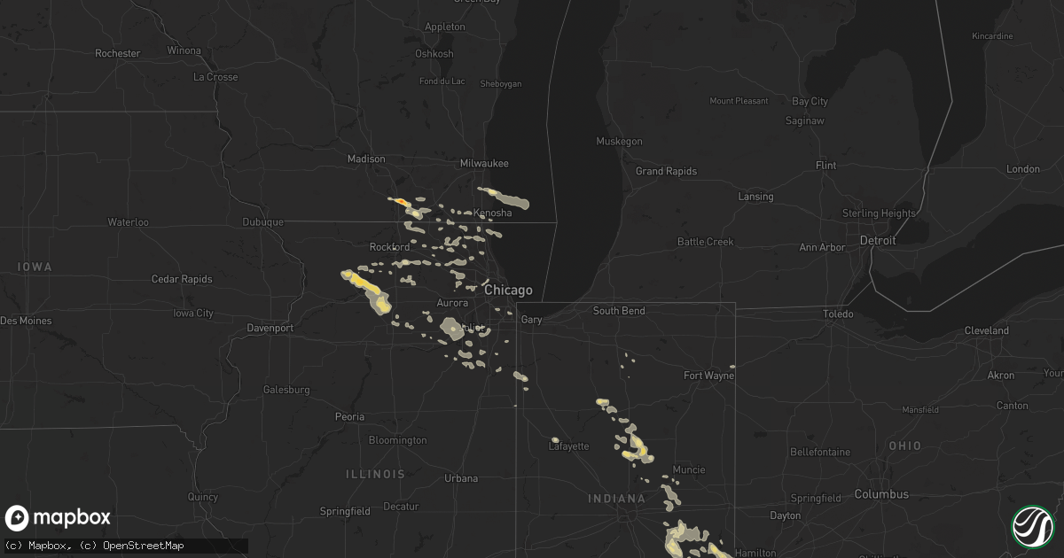
Hail Map in Arkansas on August 2, 2011
Get this storm
August 2 map
$229
one time, instant access
Download today. No call, no setup
Keep the $229
Bought the map and want the full workflow? Apply the entire $229 to a subscription within 7 days. None of it is wasted.
Every map, not just this one
This buys you this map. Subscription and you get every map we run, in the markets you choose from a few cities to whole states to nationwide. Plus real-time alerts the moment a storm fires.
Contact data
Name, contact info, occupancy, even credit band for addresses in the footprint. You go from where it hit to who to call.
Become the source they trust
Unlimited branding weather history reports on demand. You already have the documented answer ready for the property owner, and you are the one who showed up with it.
Property data and RoofTrace estimates
Pull up any address you have got, its value and the exact code rules for that jurisdiction, straight from One Click Code. Then RoofTrace estimates the squares, pitch, and roof value, priced the way you price.
Storm reports in Arkansas
Arkansas
| Date | Description |
|---|---|
| 08/02/20116:17 PM CDT | Strong winds damaged sheds and parts of several mobile homes. Some roof damage to mobile homes. |
| 08/01/20117:40 PM CDT | Strong winds damaged sheds and parts of several mobile homes. Some roof damage to mobile homes. |
| 08/01/20117:25 PM CDT | Trees and powerlines down on state highway 216 in houston. Officers also reported dime size hail. |
| 08/01/20117:09 PM CDT | Powerlines down in plumerville. |
| 08/01/20117:01 PM CDT | Severe thunderstorm producing golf ball size hail in plumerville in conway county. |
All States Impacted by Hail Map on August 2, 2011
Cities Impacted by Hail Map on August 2, 2011
- Plumerville, AR
- Center Ridge, AR
- Solgohachia, AR
- Springfield, AR
- Morrilton, AR
- Richmond, ME
- Bowdoinham, ME
- Racine, WI
- Greensburg, IN
- Animas, NM
- New Trenton, IN
- Metamora, IN
- Hamilton, OH
- Okeana, OH
- Cedar Grove, IN
- Cincinnati, OH
- Miamitown, OH
- Brookville, IN
- Harrison, OH
- Laurel, IN
- West Harrison, IN
- Cleves, OH
- Whitetail, MT
- Scobey, MT
- Isanti, MN
- Monmouth, ME
- Grenora, ND
- Williston, ND
- Dekalb, IL
- Kim, CO
- Thorndike, ME
- Redstone, MT
- Outlook, MT
- Farmington, ME
- Troy, ME
- Brooks, ME
- Janesville, WI
- Medicine Lake, MT
- Reserve, MT
- Dagmar, MT
- Plentywood, MT
- Antelope, MT
- Epping, ND
- Plainfield, VT
- Rushville, IN
- Waldron, IN
- Manilla, IN
- Milroy, IN
- Saint Paul, IN
- Truth Or Consequences, NM
- Balsam Lake, WI
- Foley, MN
- Strafford, NH
- Northwood, NH
- East Falmouth, MA
- Falmouth, MA
- Phippsburg, ME
- Southport, ME
- Woolwich, ME
- Squirrel Island, ME
- Georgetown, ME
- Boothbay, ME
- Wiscasset, ME
- Bath, ME
- Rockford, IL
- Marengo, IL
- Union, IL
- Joliet, IL
- Mokena, IL
- New Lenox, IL
- Belfast, ME
- Clare, IL
- Malta, IL
- Rochelle, IL
- Sycamore, IL
- Esmond, IL
- Essex, IL
- Bonfield, IL
- Wilmington, IL
- East Sandwich, MA
- Marstons Mills, MA
- Buzzards Bay, MA
- Mashpee, MA
- Sandwich, MA
- Forestdale, MA
- Cotuit, MA
- Woodstock, IL
- Aguilar, CO
- Kirkland, IL
- Logansport, IN
- Flaxville, MT
- Comstock, WI
- Turtle Lake, WI
- Braidwood, IL
- Exeland, WI
- Wayne, ME
- Winthrop, ME
- Paris, MI
- Reed City, MI
- Markleville, IN
- Shirley, IN
- Wilkinson, IN
- Kennard, IN
- New Castle, IN
- Pendleton, IN
- Anderson, IN
- Knightstown, IN
- Nottingham, NH
- Barrington, NH
- Pritchett, CO
- Minooka, IL
- Mount Morris, IL
- Turner, ME
- Auburn, ME
- Montello, NV
- Grouse Creek, UT
- Williamsburg, OH
- Oregon, IL
- Walsenburg, CO
- Kokomo, IN
- Greentown, IN
- Anson, ME
- Russiaville, IN
- Albany, MN
- Avon, MN
- Saint Cloud, MN
- Sartell, MN
- Sauk Rapids, MN
- Mchenry, IL
- Crystal Lake, IL
- Unity, ME
- Freedom, ME
- West Lafayette, IN
- Lucerne, IN
- Royal Center, IN
- Dixon, IL
- Polo, IL
- Franklin Grove, IL
- Ashton, IL
- Litchfield, MN
- Elwood, IL
- Channahon, IL
- Model, CO
- Trinidad, CO
- Saint Joe, AR
- Yorkville, IL
- Princeton, MN
- Zimmerman, MN
- Cambridge, MN
- Napoleon, IN
- Batesville, IN
- Osgood, IN
- Lakin, KS
- Chicago, IL
- Riverdale, IL
- Guildhall, VT
- Lancaster, NH
- Milton, WI
- Shawano, WI
- Clintonville, WI
- Wilton, ME
- Temple, ME
- Darien, WI
- Clinton, WI
- Sharon, WI
- Strong, ME
- New Vineyard, ME
- North Branch, MN
- Liberty, IN
- Franksville, WI
- Allegan, MI
- Harris, MN
- Branson, CO
- Bunker Hill, IN
- Peru, IN
- Grissom Arb, IN
- Walton, IN
- Galveston, IN
- Shafer, MN
- Center City, MN
- Hayward, WI
- Houston, AR
- Gardiner, ME
- Litchfield, ME
- Bartlett, IL
- Wayne, IL
- Saint Charles, IL
- West Chicago, IL
- Watford City, ND
- Jay, ME
- Truro, MA
- Big Rapids, MI
- Jefferson, NH
- Lunenburg, VT
- Chana, IL
- Okeechobee, FL
- Pueblo, CO
- Raton, NM
- Addison, IL
- Glen Ellyn, IL
- Glendale Heights, IL
- Lombard, IL
- Carol Stream, IL
- Wheaton, IL
- Winfield, IL
- Big Lake, MN
- Becker, MN
- Elk River, MN
- Alsip, IL
- Oak Lawn, IL
- Chicago Ridge, IL
- Noblesville, IN
- Jerusalem, AR
- Rochester, IN
- Argos, IN
- Morrill, ME
- Mendota, IL
- Earlville, IL
- Avalon, WI
- Hanover Park, IL
- Elgin, IL
- Streamwood, IL
- Bee Branch, AR
- Stillman Valley, IL
- Windfall, IN
- Tipton, IN
- Sharpsville, IN
- Burnham, ME
- Caledonia, IL
- South Beloit, IL
- Capron, IL
- Poplar Grove, IL
- Harvard, IL
- Russellville, AR
- Morocco, IN
- Milledgeville, IL
- Sublette, IL
- Forreston, IL
- West Brooklyn, IL
- Compton, IL
- Steward, IL
- Amboy, IL
- Barrington, IL
- Lake Zurich, IL
- Palatine, IL
- Danbury, WI
- Bowdoin, ME
- Delavan, WI
- Amery, WI
- Mountain Home, AR
- Middletown, IN
- Daleville, IN
- Woodburn, IN
- Charlottesville, IN
- Wadsworth, IL
- Waterville, ME
- Clinton, ME
- Perry, AR
- Pittsfield, ME
- Palmyra, ME
- Elwood, IN
- Milan, IN
- Versailles, IN
- Holcomb, KS
- Antioch, IL
- Lake Villa, IL
- Spring Grove, IL
- Mazon, IL
- Monroe Center, IL
- Algonquin, IL
- Dundee, IL
- Gilberts, IL
- Carpentersville, IL
- Bourbon, IN
- Dennis, MA
- Martin, MI
- Manhattan, IL
- Frankfort, IL
- Greenfield, IN
- Seneca, IL
- Marseilles, IL
- Sheridan, IL
- Fennville, MI
- Patagonia, AZ
- Paw Paw, MI
- Decatur, MI
- Libertyville, IL
- Gurnee, IL
- Fox Lake, IL
- Ingleside, IL
- Waukegan, IL
- Grayslake, IL
- Round Lake, IL
- Lake Village, IN
- Pembroke Township, IL
- Burlington, WI
- Zion, IL
- Hooven, OH
- Hebron, IL
- Homer, IN
- Arlington, IN
- Kingston, IL
- Detroit, ME
- Hartland, ME
- Damascus, AR
- Dresser, WI
- Salem, WI
- Bristol, WI
- Sunman, IN
- Cushing, WI
- Luck, WI
- Kentland, IN
- Sheldon, IL
- Elmhurst, IL
- Bensenville, IL
- Melrose Park, IL
- Saint Croix Falls, WI
- Grantsburg, WI
- Butternut, WI
- Mattapoisett, MA
- Centuria, WI
- Taylors Falls, MN
- Kankakee, IL
- Momence, IL
- Saint Anne, IL
- Leeds, ME
- Oldenburg, IN
- Morris, IL
- Clear Lake, MN
- Lee, NH
- Kempton, IN
- Batavia, IL
- Willmar, MN
- Kandiyohi, MN
- Osceola, WI
- Braceville, IL
- Newark, IL
- Shorewood, IL
- Plainfield, IL
- Oswego, IL
- South Dennis, MA
- Lake Geneva, WI
- Saint Joseph, MI
- Atwater, MN
- Hebron, KY
- North Bend, OH
- Elkhorn, WI
- Schiller Park, IL
- Franklin Park, IL
- Des Plaines, IL
- Walkerville, MI
- Reading, MA
- Trevett, ME
- Harpswell, ME
- Boothbay Harbor, ME
- Belvidere, IL
- Garden Prairie, IL
- Granada, CO
- Davis Junction, IL
- Genoa, IL
- Rush City, MN
- Saint Francis, MN
- Ojibwa, WI
- Greenbrier, AR
- Calico Rock, AR
- Norfork, AR
- Leland, IL
- Hampshire, IL
- Genoa City, WI
- Richmond, IL
- Twin Lakes, WI
- Wonder Lake, IL
- Pleasant Prairie, WI
- Kenosha, WI
- Booker, TX
- Atlanta, IN
- Wauconda, IL
- Lindstrom, MN
- Chisago City, MN
- Stacy, MN
- Clearwater, MN
- Canal Point, FL
- Tippecanoe, IN
- Crete, IL
- Beecher, IL
- Brunswick, ME
- Minong, WI
- Gainesville, FL
- Felicity, OH
- Georgetown, OH
- Sandwich, IL
- Somonauk, IL
- Caledonia, WI
- Huntley, IL
- Kents Hill, ME
- Gwynneville, IN
- Morristown, IN
- Springbrook, WI
- Las Animas, CO
- Bisbee, AZ
- Plano, IL
- Osterville, MA
- Dixfield, ME
- Leaf River, IL
- Byron, IL
- Grant Park, IL
- Micanopy, FL
- Bourbonnais, IL
- Manteno, IL
- Carthage, IN
- Shelbyville, IN
- Connersville, IN
- Glenwood, IN
- North Falmouth, MA
- Vernon Hills, IL
- Lincolnshire, IL
- Lake Forest, IL
- Buffalo Grove, IL
- Peotone, IL
- Elizabeth, AR


