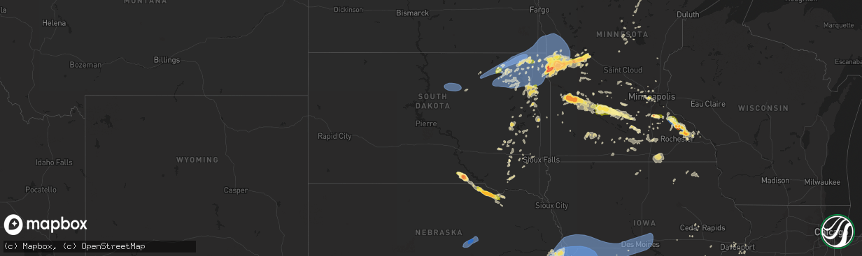
Hail Map in South Dakota on July 31, 2024
The weather event in South Dakota on July 31, 2024 includes Wind, Hail, and Tornado maps. 25 states and 1,493 cities were impacted and suffered possible damage. The total estimated number of properties impacted is 1,093.
Want more than just the map?
Turn this storm into a full workflow.
- Owner + property data so you know who to knock
- OnDemand branded weather history reports to win the "did we even have hail?" argument
- RoofTrace estimate so reps stop guessing numbers at the door
Bought this map? Upgrade within 7 days and we'll credit the $230. (10-15 min setup call)
Wind
Hail
Tornado
1,093
Estimated number of impacted properties by a 1.00" hail or larger0
Estimated number of impacted properties by a 1.75" hail or larger0
Estimated number of impacted properties by a 2.50" hail or largerStorm reports in South Dakota
South Dakota
| Date | Description |
|---|---|
| 07/31/20246:57 PM CDT | Asos station katy watertown muni ap. |
| 07/31/20246:55 PM CDT | Steady 40 to 50 mph winds with a few gusts to 60 mph. |
| 07/31/20246:42 PM CDT | A local report indicates 1.00 inch wind near Burke |
| 07/31/20245:20 PM CDT | A local report indicates 1.25 inch wind near 3 NNE Sisseton Municipa |
| 07/31/20244:15 PM CDT | Nickel to quarter size hail. |
| 07/31/202412:59 PM CDT | Mesonet station mrls2 hillhead 3 wsw. |
| 07/31/202412:45 PM CDT | Estimated 60 mph winds and branches down in yard. Radar estimated time. |
| 07/31/202412:45 PM CDT | Report of broken widows from wind/debris. |
| 07/31/202412:20 PM CDT | Damage to dairy barn roof. |
| 07/31/202412:15 PM CDT | Awos station k8d3 2 e sisseton. |
| 07/31/202412:09 PM CDT | Mesonet station 55 summit |
| 07/31/202412:04 PM CDT | Summit at mm 207 sddot station. |
| 07/31/202412:04 PM CDT | Mesonet station 2 lake city |
| 07/31/202412:00 PM CDT | Report relayed on social media. |
| 07/31/202412:00 PM CDT | Corn blown down due to thunderstorm wind. Radar estimated time. |
| 07/31/202411:56 AM CDT | Personal weather station. |
| 07/31/202411:45 AM CDT | Photo sent from marshall county em. Time estimated by radar. |
| 07/31/202411:40 AM CDT | Mesonet station btns2 britton 8 s |
| 07/31/202411:37 AM CDT | Mesonet station 45 andover |
| 07/31/202411:30 AM CDT | Langford pws - ksdlangf2. |
| 07/31/202411:15 AM CDT | Mesonet station gots2 groton 9 nne |
| 07/31/20249:03 AM CDT | Mesonet station 56 tolstoy |
| 07/30/202410:35 PM CDT | Corrects previous hail report from canistota. Social media report with picture of quarter sized hail southeast of canastota. |
| 07/30/202410:30 PM CDT | Social media report with picture of quarter sized hail southeast of canastota. |
| 07/30/20249:00 PM CDT | Corrects previous tstm wnd dmg report from brookings. Social media report with picture of a downed tree branch approximately 4-6 inches in diameter. Estimated time betw |
| 07/30/20249:00 PM CDT | Social media report of medium branches down |
| 07/30/20248:30 PM CDT | Social media report with picture of a downed tree branch approximately 4-6 inches in diameter. Estimated time between 8:30 and 9:30pm. Time estimate matches with radar. |
| 07/30/20248:30 PM CDT | Downed large tree branch at arrowhead apartments. |
| 07/30/20248:30 PM CDT | Social media report of downed branches about 3 inches in diameter. Time estimated between 8 and 9 pm during the storm. Used radar to estimate time of greatest winds. |
| 07/30/20248:25 PM CDT | Large tree limbed downed. |
| 07/30/20248:04 PM CDT | Personal weather station. |
| 07/30/20247:56 PM CDT | Mesonet station 213 sd rwis alexandria. |
| 07/30/20247:55 PM CDT | Mesonet station vgas2 volga |
| 07/30/20247:00 PM CDT | Social media report with picture of hail estimated to be 2 inches. |
| 07/30/20247:00 PM CDT | 10 inch branch down and blocking main street... As well as 3/4 inch hail. |
All States Impacted by Hail Map on July 31, 2024
Cities Impacted by Hail Map on July 31, 2024
- Unionville, IA
- Moravia, IA
- Novinger, MO
- Manito, IL
- Forest City, IL
- Topeka, IL
- Greentop, MO
- Queen City, MO
- Byron, IL
- Oregon, IL
- Leaf River, IL
- Kirksville, MO
- Memphis, MO
- Eagle Butte, SD
- Wenona, IL
- Stillman Valley, IL
- Downing, MO
- Brashear, MO
- Chana, IL
- Streator, IL
- Colchester, IL
- Hamilton, IL
- Warsaw, IL
- Milan, MO
- Plymouth, IL
- Macomb, IL
- Mandan, ND
- Flanagan, IL
- Littleton, IL
- Industry, IL
- Bismarck, ND
- Oskaloosa, IA
- El Paso, IL
- Tennessee, IL
- Davis Junction, IL
- Rochelle, IL
- Long Point, IL
- Green City, MO
- Chenoa, IL
- Baring, MO
- Pontiac, IL
- Green Castle, MO
- Meadow, SD
- Odell, IL
- Menoken, ND
- Gettysburg, SD
- Shannon City, IA
- Sterling, ND
- Strawn, IL
- Sibley, IL
- Saybrook, IL
- Fairbury, IL
- Rushville, IL
- Murray, IA
- Colfax, IL
- Gibson City, IL
- Cropsey, IL
- Osceola, IA
- Tuttle, ND
- Robinson, ND
- Anchor, IL
- Penfield, IL
- Gifford, IL
- Chariton, IA
- Paxton, IL
- Melvin, IL
- Knoxville, IA
- Thayer, IA
- Ellston, IA
- Rantoul, IL
- Ludlow, IL
- Hoven, SD
- Tolstoy, SD
- Onaka, SD
- Woodworth, ND
- Harvey, IA
- Ottumwa, IA
- Blakesburg, IA
- Albia, IA
- Newman, IL
- Weldon, IA
- Russell, IA
- Urbana, IL
- Tolono, IL
- Saint Joseph, IL
- Philo, IL
- Chambersburg, IL
- Potomac, IL
- Armstrong, IL
- Rankin, IL
- Melrose, IA
- Sykeston, ND
- Ogden, IL
- Griggsville, IL
- New Salem, IL
- Baylis, IL
- Sidney, IL
- Broadlands, IL
- Carrington, ND
- Pella, IA
- Leighton, IA
- Tracy, IA
- Eddyville, IA
- Hume, IL
- Allerton, IL
- Homer, IL
- Brocton, IL
- Fithian, IL
- Collison, IL
- Barry, IL
- Pittsfield, IL
- Seneca, SD
- Faulkton, SD
- Cresbard, SD
- Chrisman, IL
- Metcalf, IL
- Hamilton, IA
- Bowdon, ND
- Drakesville, IA
- Lacona, IA
- Rockport, IL
- Indianola, IL
- Sidell, IL
- Paris, IL
- Bloomfield, IA
- Elliott, IL
- Foosland, IL
- Fisher, IL
- Loda, IL
- Dewey, IL
- Thomasboro, IL
- Champaign, IL
- Royal, IL
- Hoopeston, IL
- Rossville, IL
- Henning, IL
- Tilton, IL
- Alvin, IL
- Westville, IL
- Georgetown, IL
- Danville, IL
- Fairmount, IL
- Catlin, IL
- Oakwood, IL
- Muncie, IL
- Covington, IN
- Veedersburg, IN
- Attica, IN
- Ambia, IN
- Waynetown, IN
- Cayuga, IN
- Williamsport, IN
- State Line, IN
- Perrysville, IN
- Mellott, IN
- Newtown, IN
- Wingate, IN
- West Lebanon, IN
- Bismarck, IL
- Kingman, IN
- Hillsboro, IN
- Ridge Farm, IL
- Dana, IN
- Ipswich, SD
- Columbia, IA
- Crawfordsville, IN
- Alamo, IN
- Marshall, IN
- Bloomingdale, IN
- Humeston, IA
- Promise City, IA
- Woodburn, IA
- Aberdeen, SD
- Seymour, IA
- Corydon, IA
- Maywood, NE
- Hayes Center, NE
- Wellfleet, NE
- New Rockford, ND
- Keosauqua, IA
- Centerville, IA
- Plano, IA
- Mystic, IA
- Andover, SD
- Edgeley, ND
- Williamson, IA
- Lovilia, IA
- Sullivan, IL
- Bethany, IL
- Milton, IA
- Cantril, IA
- Argyle, IA
- Ypsilanti, ND
- Maxwell, NE
- Alexandria, MO
- Curtis, NE
- Groton, SD
- Pulaski, IA
- Udell, IA
- Marion, ND
- Berlin, ND
- Dickey, ND
- Exline, IA
- Moulton, IA
- Columbia, SD
- Bath, SD
- Amherst, SD
- Claremont, SD
- Langford, SD
- Moorefield, NE
- Webster, SD
- Bristol, SD
- Spiritwood, ND
- Litchville, ND
- Brady, NE
- Mattoon, IL
- Jamestown, ND
- Stratford, SD
- Conde, SD
- Ferney, SD
- Pierpont, SD
- Roslyn, SD
- Britton, SD
- Lancaster, MO
- Coatsville, MO
- Arbela, MO
- Sanborn, ND
- Wimbledon, ND
- Farnam, NE
- Eden, SD
- Waubay, SD
- Grenville, SD
- Veblen, SD
- Lake City, SD
- Springville, IN
- Bedford, IN
- Bloomington, IN
- Kathryn, ND
- Rogers, ND
- Gothenburg, NE
- Cozad, NE
- Luray, MO
- Mount Sterling, IA
- Florence, SD
- Cincinnati, IA
- Wilmot, SD
- Peever, SD
- Sisseton, SD
- Summit, SD
- Ortley, SD
- Ord, NE
- Comstock, NE
- Elyria, NE
- Claire City, SD
- Ericson, NE
- Scotia, NE
- Lidgerwood, ND
- South Shore, SD
- Twin Brooks, SD
- Marvin, SD
- Heltonville, IN
- Forman, ND
- Willow Island, NE
- Corona, SD
- New Effington, SD
- Hankinson, ND
- Beardsley, MN
- Milbank, SD
- Browns Valley, MN
- Willow Hill, IL
- Newton, IL
- Oblong, IL
- Havana, ND
- Yale, IL
- Rutledge, MO
- Watertown, SD
- Ortonville, MN
- Clinton, MN
- Fairmount, ND
- Rosholt, SD
- Wheaton, MN
- Graceville, MN
- Dumont, MN
- Mount Sterling, IL
- Dahlgren, IL
- Gorin, MO
- Dundas, IL
- Claremont, IL
- Robinson, IL
- Olney, IL
- Sumner, IL
- Lexington, NE
- Bardstown, KY
- Tintah, MN
- Wahpeton, ND
- Campbell, MN
- Barry, MN
- Wyaconda, MO
- Flat Rock, IL
- Mantador, ND
- Wyndmere, ND
- Brownstown, IN
- Stockholm, SD
- Bridgeport, IL
- Breckenridge, MN
- Donnelly, MN
- Nashua, MN
- Elbow Lake, MN
- Norcross, MN
- Herman, MN
- Kahoka, MO
- Williamstown, MO
- Saint Patrick, MO
- Buxton, ND
- Cummings, ND
- Campbellsburg, IN
- Vallonia, IN
- Lawrenceville, IL
- Springerton, IL
- Oaktown, IN
- Wendell, MN
- Foxhome, MN
- Chokio, MN
- Paoli, IN
- Big Stone City, SD
- Bellingham, MN
- Hillsboro, ND
- Caledonia, ND
- Montezuma, GA
- La Belle, MO
- Monticello, MO
- Canton, MO
- Moorhead, MN
- Salem, IN
- Quincy, IL
- French Lick, IN
- West Baden Springs, IN
- Hardinsburg, IN
- Sabin, MN
- Comstock, MN
- Fowler, IL
- Correll, MN
- Odessa, MN
- Charlestown, IN
- Rothsay, MN
- Fergus Falls, MN
- Barrett, MN
- Hoffman, MN
- Morris, MN
- Ashby, MN
- Dalton, MN
- Elizabeth, MN
- Carmi, IL
- Memphis, IN
- Henryville, IN
- Stockville, NE
- Pekin, IN
- Liberty, IL
- Payson, IL
- Scottsburg, IN
- Jeffersonville, IN
- Prospect, KY
- Appleton, MN
- Barnesville, MN
- Underwood, IN
- Ferdinand, IN
- Thief River Falls, MN
- Plainville, IL
- Holloway, MN
- Hancock, MN
- Cannelburg, IN
- Loogootee, IN
- Clayton, IL
- Louisville, KY
- Borden, IN
- Mitchell, IN
- Ulen, MN
- Benson, MN
- Clontarf, MN
- McCook, NE
- Indianola, NE
- Funk, NE
- Danvers, MN
- Glennville, GA
- Orleans, IN
- Sellersburg, IN
- Floyds Knobs, IN
- Cordele, GA
- Waubun, MN
- Campbell, NE
- Glenwood, MN
- Bartley, NE
- Reidsville, GA
- Wood River, NE
- Murdock, MN
- Doniphan, NE
- Sunburg, MN
- Pennock, MN
- Simpsonville, KY
- Taylorsville, KY
- Fisherville, KY
- Cambridge, NE
- Holbrook, NE
- Wilsonville, NE
- Arapahoe, NE
- Beaver City, NE
- Hendley, NE
- Blue Hill, NE
- Guide Rock, NE
- Lawrence, NE
- Geneva, NE
- Sutton, NE
- Coxs Creek, KY
- Mount Washington, KY
- Alda, NE
- Edison, NE
- Oxford, NE
- Deweese, NE
- Nelson, NE
- New Hope, KY
- Loretto, KY
- New Haven, KY
- Springfield, KY
- Grafton, NE
- Hodgenville, KY
- Sonora, KY
- Lebanon, KY
- Naytahwaush, MN
- Bedford, KY
- Vevay, IN
- Madison, IN
- Milton, KY
- Carrollton, KY
- Lebanon, NE
- Almena, KS
- Long Island, KS
- Prairie View, KS
- Phillipsburg, KS
- Edgar, NE
- Warroad, MN
- Strathcona, MN
- Fairmont, NE
- Campbellsville, KY
- Buffalo, KY
- Grinnell, KS
- Hill City, KS
- Milligan, NE
- Exeter, NE
- Friend, NE
- Beaver Crossing, NE
- Dorchester, NE
- Milford, NE
- Crete, NE
- Trumbull, NE
- Hastings, NE
- Inland, NE
- Brainerd, MN
- Raywick, KY
- Bagley, MN
- Mahnomen, MN
- Glenvil, NE
- Fairfield, NE
- Holdrege, NE
- Broxton, GA
- Denton, GA
- Jacksonville, GA
- Pierz, MN
- Gove, KS
- Grainfield, KS
- Glade, KS
- Seward, NE
- Pleasant Dale, NE
- Lenora, KS
- Shickley, NE
- Strang, NE
- Worthville, KY
- Sanders, KY
- Jonesboro, GA
- Norton, KS
- Lenox, GA
- Tifton, GA
- Bladen, NE
- Stamford, NE
- Norcatur, KS
- Dawson, GA
- Hoxie, KS
- Quinter, KS
- Park, KS
- Orleans, NE
- Alma, NE
- Agra, KS
- Kirwin, KS
- Kensington, KS
- Penokee, KS
- Bogue, KS
- Stockton, KS
- Damar, KS
- Carleton, NE
- Bruning, NE
- Alexandria, NE
- Denton, NE
- Lincoln, NE
- Malcolm, NE
- Raymond, NE
- Davey, NE
- Ceresco, NE
- Martell, NE
- Ohiowa, NE
- Hallam, NE
- Hickman, NE
- Sprague, NE
- Roca, NE
- Valparaiso, NE
- Ambrose, GA
- Wray, GA
- Emily, MN
- Pequot Lakes, MN
- Cosmos, MN
- Hutchinson, MN
- Sacred Heart, MN
- Granite Falls, MN
- Echo, MN
- Kimball, MN
- Aitkin, MN
- Magnolia, KY
- New London, MN
- Atwater, MN
- Litchfield, MN
- Grove City, MN
- Starbuck, MN
- Minneapolis, MN
- Hopkins, MN
- Logan, KS
- Grantville, GA
- Hogansville, GA
- Greenville, GA
- Morland, KS
- Collyer, KS
- Pearl, IL
- Butler, GA
- Mount Sherman, KY
- South Haven, MN
- Culloden, GA
- Gaylord, KS
- Cedar, KS
- Athol, KS
- Adams, NE
- Walton, NE
- Panama, NE
- Bennet, NE
- Palmyra, NE
- Waverly, NE
- South Saint Paul, MN
- Saint Paul, MN
- Greensburg, KY
- Summersville, KY
- Republican City, NE
- Davenport, NE
- Climax, GA
- Wayzata, MN
- Eatonton, GA
- Sparks, GA
- Smith Center, KS
- Portis, KS
- Ashland, NE
- Greenwood, NE
- Eagle, NE
- Douglas, NE
- Fremont, NE
- Colon, NE
- Ithaca, NE
- Alvo, NE
- Valley, NE
- Yutan, NE
- Memphis, NE
- Mead, NE
- Wahoo, NE
- Elmwood, NE
- Suitland, MD
- Temple Hills, MD
- Oxon Hill, MD
- Upper Marlboro, MD
- District Heights, MD
- Andrews Air Force Base, MD
- Clinton, MD
- Fort Washington, MD
- Brandywine, MD
- Cheltenham, MD
- Smyrna, DE
- Townsend, DE
- Savannah, GA
- Wilcox, NE
- Newton, GA
- Alberta, MN
- Byron, GA
- Henderson, NE
- Damascus, GA
- Arlington, GA
- Royalton, MN
- Hereford, TX
- Renville, MN
- Ayr, NE
- Eden Prairie, MN
- Alexandria, VA
- McLean, VA
- Omer, MI
- Mount Rainier, MD
- Washington, DC
- Bethesda, MD
- Chevy Chase, MD
- Hyattsville, MD
- Arlington, VA
- Brentwood, MD
- Takoma Park, MD
- Middletown, DE
- Danube, MN
- Olivia, MN
- Bird Island, MN
- Unadilla, NE
- Waterloo, NE
- Burr, NE
- Weeping Water, NE
- Gretna, NE
- Avoca, NE
- Syracuse, NE
- Murdock, NE
- Elkhorn, NE
- Omaha, NE
- South Bend, NE
- Springfield, NE
- Louisville, NE
- Otoe, NE
- Washington, NE
- Bennington, NE
- Manley, NE
- Arlington, NE
- Blair, NE
- Kennard, NE
- Bellevue, NE
- Fort Calhoun, NE
- Papillion, NE
- La Vista, NE
- Crescent, IA
- Honey Creek, IA
- Murray, NE
- Dunbar, NE
- Carter Lake, IA
- Boys Town, NE
- Nehawka, NE
- Plattsmouth, NE
- Cedar Creek, NE
- Missouri Valley, IA
- Wakeeney, KS
- Alton, KS
- Thomasville, GA
- Garland, NE
- Mays Landing, NJ
- Hammonton, NJ
- Redwood Falls, MN
- Vienna, VA
- Dunn Loring, VA
- Falls Church, VA
- Annandale, VA
- Fairfax, VA
- Lanham, MD
- Capitol Heights, MD
- Kensington, MN
- Farwell, MN
- Downs, KS
- Esbon, KS
- Mankato, KS
- Beloit, KS
- Jamestown, KS
- Concordia, KS
- Leary, GA
- Hamel, MN
- Loretto, MN
- Glencoe, MN
- Plato, MN
- Osborne, KS
- Minnetonka, MN
- Silver Spring, MD
- Stinnett, TX
- Giltner, NE
- Harvard, NE
- Woodston, KS
- Randall, KS
- Jewell, KS
- Fredericksburg, OH
- Apple Creek, OH
- Long Lake, MN
- Northfield, MN
- Lester Prairie, MN
- Morton, MN
- Grasston, MN
- Norway, KS
- Council Bluffs, IA
- Modale, IA
- Neola, IA
- Underwood, IA
- Woodbine, IA
- Pisgah, IA
- Offutt Afb, NE
- Logan, IA
- Magnolia, IA
- Mondamin, IA
- Alexandria, MN
- Lowry, MN
- Hector, MN
- Pacific Junction, IA
- Stewart, MN
- Buffalo Lake, MN
- Silver City, IA
- Persia, IA
- Treynor, IA
- Minden, IA
- Mineola, IA
- Glenwood, IA
- McClelland, IA
- Shelby, IA
- Gibbon, MN
- Winthrop, MN
- Fairfax, MN
- Union, NE
- Nebraska City, NE
- Thurman, IA
- Percival, IA
- Portsmouth, IA
- Tabor, IA
- Dunlap, IA
- Hancock, IA
- Macedonia, IA
- Hastings, IA
- Avoca, IA
- Essex, IA
- Oakland, IA
- Henderson, IA
- Malvern, IA
- Carson, IA
- Red Oak, IA
- Imogene, IA
- Emerson, IA
- Panama, IA
- Farragut, IA
- Randolph, IA
- Coin, IA
- Sidney, IA
- Hamburg, IA
- Riverton, IA
- Shenandoah, IA
- Clarinda, IA
- Harlan, IA
- Elliott, IA
- Stanton, IA
- New Market, IA
- Yorktown, IA
- Griswold, IA
- Villisca, IA
- Brownton, MN
- Farmington, MN
- Clayton, AL
- Eufaula, AL
- Glen Elder, KS
- Franklin, MN
- Georgetown, GA
- Champlin, MN
- Anoka, MN
- Dwight, NE
- Bee, NE
- Inavale, NE
- Wyoming, MN
- Ogallah, KS
- Glasco, KS
- Luck, WI
- Centuria, WI
- Saint Croix Falls, WI
- Ocala, FL
- Summerfield, FL
- Roberta, GA
- Bradley, SD
- Cyrus, MN
- Ransom, KS
- Musella, GA
- Cannon Falls, MN
- Randolph, MN
- Springfield, VA
- Absecon, NJ
- Arlington, MN
- Harwood, MD
- Lothian, MD
- Gaylord, MN
- Henderson, MN
- Le Sueur, MN
- Nelson, MN
- Lakeville, MN
- Hastings, MN
- Delphos, KS
- Aurora, KS
- Webster, MN
- Dennison, MN
- Belle Plaine, MN
- Villard, MN
- Utica, KS
- New Middletown, IN
- Corydon, IN
- Weston, NE
- Elko New Market, MN
- Lonsdale, MN
- Naponee, NE
- Goodhue, MN
- Red Wing, MN
- Welch, MN
- Ellis, KS
- Brownell, KS
- Gregory, SD
- Burke, SD
- Herrick, SD
- Saint Charles, SD
- McCracken, KS
- Hays, KS
- Bazine, KS
- Garfield, MN
- Brandon, MN
- Belleview, FL
- Strandburg, SD
- Elizabeth, IN
- Miltonvale, KS
- Osakis, MN
- Clyde, KS
- Marne, IA
- Lewis, IA
- Walnut, IA
- Atlantic, IA
- Cumberland, IA
- Grant, IA
- Nodaway, IA
- Earling, IA
- Gravity, IA
- Corning, IA
- Carbon, IA
- Irwin, IA
- Audubon, IA
- Wiota, IA
- Exira, IA
- Defiance, IA
- Elk Horn, IA
- Kirkman, IA
- Brayton, IA
- Kimballton, IA
- Bridgewater, IA
- Massena, IA
- Westphalia, IA
- Alexander, KS
- Lake City, MN
- Mazeppa, MN
- Zumbro Falls, MN
- Saint Peter, MN
- Kasota, MN
- Castlewood, SD
- Boyd, MN
- Montevideo, MN
- Dawson, MN
- Zumbrota, MN
- Kranzburg, SD
- Goodwin, SD
- Faribault, MN
- Clay Center, KS
- Tescott, KS
- Blanchard, IA
- Brookville, KS
- Newville, AL
- Midland City, AL
- Ozark, AL
- Cleveland, MN
- Madison Lake, MN
- Bunker Hill, KS
- Russell, KS
- Sylvan Grove, KS
- Dorrance, KS
- Lincoln, KS
- Lucas, KS
- Luray, KS
- Beverly, KS
- Barnard, KS
- Wilson, KS
- Ellsworth, KS
- Salina, KS
- Minneapolis, KS
- Lindsborg, KS
- Assaria, KS
- Bennington, KS
- Prescott, IA
- Lenox, IA
- Sharpsburg, IA
- Clearfield, IA
- Diagonal, IA
- Fontanelle, IA
- Anita, IA
- Creston, IA
- Bedford, IA
- Orient, IA
- Adair, IA
- Greenfield, IA
- Cromwell, IA
- Casey, IA
- Hamlin, IA
- Guthrie Center, IA
- Stuart, IA
- Menlo, IA
- Bonesteel, SD
- Braddyville, IA
- Clarkfield, MN
- Watson, MN
- Shambaugh, IA
- Hopkins, MO
- Clearmont, MO
- Clear Lake, SD
- La Crosse, KS
- Ness City, KS
- Nekoma, KS
- Madison, MN
- College Springs, IA
- Carlos, MN
- Elberton, GA
- Friona, TX
- Leonardtown, MD
- Maynard, MN
- Elysian, MN
- Bridgewater, SD
- Bison, KS
- Rush Center, KS
- Janesville, MN
- Le Center, MN
- Liebenthal, KS
- Millville, MN
- Sunray, TX
- Burdett, KS
- Rozel, KS
- Woodbine, KS
- Ramona, KS
- Tampa, KS
- New Cambria, KS
- Solomon, KS
- Chapman, KS
- Hope, KS
- Abilene, KS
- Enterprise, KS
- Gypsum, KS
- Herington, KS
- Longford, KS
- Talmage, KS
- Earlham, IA
- Dexter, IA
- Winterset, IA
- Adel, IA
- Redfield, IA
- Peru, IA
- Saint Charles, IA
- Benton, IA
- Blockton, IA
- Mount Ayr, IA
- Tingley, IA
- Kellerton, IA
- Nerstrand, MN
- Hanston, KS
- Clara City, MN
- Emery, SD
- Olivet, SD
- Parkston, SD
- Waterville, MN
- Sheridan, MO
- Albert, KS
- Olmitz, KS
- Otis, KS
- Good Thunder, MN
- Erwin, SD
- Morganville, KS
- Elgin, MN
- Rochester, MN
- De Smet, SD
- Alexandria, SD
- Kellogg, MN
- Plainview, MN
- Schoenchen, KS
- Larned, KS
- Pfeifer, KS
- Hoisington, KS
- Great Bend, KS
- Pawnee Rock, KS
- Spencer, NE
- Bristow, NE
- Lynch, NE
- St John, KS
- Van Meter, IA
- De Soto, IA
- Waukee, IA
- Dallas Center, IA
- Booneville, IA
- West Des Moines, IA
- Cumming, IA
- Prole, IA
- Norwalk, IA
- Patterson, IA
- Hartwell, GA
- Carthage, SD
- Butte, NE
- Fairfax, SD
- Wood Lake, MN
- Belview, MN
- Waseca, MN
- Owatonna, MN
- Willmar, MN
- Kenyon, MN
- Wakefield, KS
- Gorham, KS
- Ashford, AL
- Columbia, AL
- Headland, AL
- Canistota, SD
- Bruce, SD
- Brookings, SD
- Clopton, AL
- Abbeville, AL
- Indianola, IA
- Bevington, IA
- Johnston, IA
- Martensdale, IA
- Des Moines, IA
- Urbandale, IA
- Ankeny, IA
- Clive, IA
- Windsor Heights, IA
- Grimes, IA
- Carlisle, IA
- Polk City, IA
- Riley, KS
- Spencer, SD
- Oneill, NE
- Salem, SD
- Canova, SD
- Stockbridge, GA
- Hampton, GA
- Alma, GA
- Kandiyohi, MN
- Lake Lillian, MN
- Pine Island, MN
- Ivanhoe, MN
- White, SD
- Taunton, MN
- Estelline, SD
- Winfred, SD
- Madison, SD
- White City, KS
- Junction City, KS
- Milford, KS
- Manhattan, KS
- Ogden, KS
- Fort Riley, KS
- Verdigre, NE
- Niobrara, NE
- Vienna, SD
- Hayti, SD
- Lamberton, MN
- Storden, MN
- Mitchell, SD
- Eyota, MN
- Pemberton, MN
- Mapleton, MN
- Bryant, SD
- Bladensburg, MD
- Fedora, SD
- Howard, SD
- Artesian, SD
- Riverdale, MD
- Paradise, KS
- Westbrook, MN
- Kinsley, KS
- Oldham, SD
- Arlington, SD
- Ramona, SD
- Lynd, MN
- Arco, MN
- Russell, MN
- Pleasant Hill, IA
- Bondurant, IA
- Berwick, IA
- Elkhart, IA
- Mitchellville, IA
- Prairie City, IA
- Runnells, IA
- Collins, IA
- Maxwell, IA
- Altoona, IA
- Colfax, IA
- Mingo, IA
- Hartford, IA
- Swan, IA
- Olsburg, KS
- Saint George, KS
- Wilsey, KS
- Dwight, KS
- Alta Vista, KS
- Alma, KS
- Council Grove, KS
- Westmoreland, KS
- Baxter, IA
- Wamego, KS
- Natoma, KS
- Clio, AL
- Rosemount, MN
- Onaga, KS
- Belvue, KS
- McFarland, KS
- Paxico, KS
- Eskridge, KS
- Maple Hill, KS
- Harveyville, KS
- Saint Marys, KS
- Dover, MN
- Saint Charles, MN
- Altura, MN
- Sanborn, MN
- Jeffers, MN
- Iroquois, SD
- Northboro, IA
- Garfield, KS
- Waldorf, MN
- Gallatin, MO
- Winnetoon, NE
- Creighton, NE
- Minnesota Lake, MN
- Fulton, SD
- Hope, MN
- Ellendale, MN
- Havensville, KS
- Soldier, KS
- Comfrey, MN
- Delia, KS
- Emmett, KS
- Springfield, MN
- Bingham Lake, MN
- Berryton, KS
- Scranton, KS
- Wakarusa, KS
- Carbondale, KS
- Burlingame, KS
- Quenemo, KS
- Rossville, KS
- Topeka, KS
- Pomona, KS
- Auburn, KS
- Silver Lake, KS
- Overbrook, KS
- Baldwin City, KS
- Ottawa, KS
- Perry, KS
- Grantville, KS
- Muscotah, KS
- Effingham, KS
- Lecompton, KS
- Lawrence, KS
- Denison, KS
- Nortonville, KS
- Whiting, KS
- Oskaloosa, KS
- Hoyt, KS
- Meriden, KS
- Tecumseh, KS
- Holton, KS
- Ozawkie, KS
- Valley Falls, KS
- Mayetta, KS
- Horton, KS
- Circleville, KS
- Lorraine, KS
- Kanopolis, KS
- Geneseo, KS
- Marquette, KS
- Falun, KS
- Durham, KS
- Jamesport, MO
- Mountain Lake, MN
- Rosendale, MO
- Blooming Prairie, MN
- Claremont, MN
- Lost Springs, KS
- Lincolnville, KS
- Winchester, KS
- Wellsville, KS
- McLouth, KS
- Eudora, KS
- Tonganoxie, KS
- Cummings, KS
- Everest, KS
- Atchison, KS
- Lancaster, KS
- Bronwood, GA
- Leesburg, GA
- Butterfield, MN
- New Liberty, KY
- Owenton, KY
- Blomkest, MN
- Raymond, MN
- Garden City, MN
- Madelia, MN
- Lake Crystal, MN
- Minnesota City, MN
- Fort Valley, GA
- Rea, MO
- Bolckow, MO
- Burdick, KS
- Easton, KS
- Rushville, MO
- Leavenworth, KS
- Linwood, KS
- Texico, NM
- Guilford, MO
- Clifton, KS
- Gilman City, MO
- Garvin, MN
- Balaton, MN
- Fairmont, MN
- Welcome, MN
- De Soto, KS
- Olathe, KS
- Edgerton, KS
- Gardner, KS
- Emporia, KS
- Strong City, KS
- Platte City, MO
- Fort Leavenworth, KS
- Basehor, KS
- Lansing, KS
- Kansas City, KS
- De Kalb, MO
- Bonner Springs, KS
- Weston, MO
- Faucett, MO
- Agency, MO
- Wathena, KS
- Saint Joseph, MO
- Dearborn, MO
- Bendena, KS
- Troy, KS
- Netawaka, KS
- Denton, KS
- Elwood, KS
- Amazonia, MO
- Oregon, MO
- Savannah, MO
- Cosby, MO
- Easton, MO
- Farley, MO
- Lenexa, KS
- Camden Point, MO
- New Century, KS
- Kansas City, MO
- Shawnee, KS
- Waldron, MO
- Allen, KS
- Center, NE
- Saint James, MN
- West Concord, MN
- Lewisville, MN
- Ellinwood, KS
- Brooklyn, IA
- Smithville, MO
- Riverside, MO
- Prairie Village, KS
- Edgerton, MO
- Stewartsville, MO
- Union Star, MO
- Mission, KS
- Clarksdale, MO
- Helena, MO
- King City, MO
- Trimble, MO
- Amity, MO
- Gower, MO
- Leawood, KS
- Overland Park, KS
- Marion, SD
- Scotland, SD
- Marengo, IA
- Montezuma, IA
- Forest City, IA
- Britt, IA
- Garner, IA
- Crystal Lake, IA
- Statesville, NC
- Menno, SD
- Lesterville, SD
- Windom, MN
- Liberty, MO
- Kearney, MO
- Grandview, MO
- Lafayette, MN
- Lees Summit, MO
- Independence, MO
- Lawson, MO
- Missouri City, MO
- Plattsburg, MO
- Greenwood, MO
- Lathrop, MO
- Blue Springs, MO
- Holt, MO
- Excelsior Springs, MO
- Osborn, MO
- Maysville, MO
- Turney, MO
- Cameron, MO
- New Richland, MN
- Kingman, KS
- Parker, SD
- Rollingstone, MN
- Buckner, MO
- Orrick, MO
- Sibley, MO
- Polo, MO
- Grain Valley, MO
- Novelty, MO
- Edina, MO
- Ainsworth, IA
- Delavan, MN
- Lone Tree, IA
- Cedar Rapids, IA
- Palo, IA
- Webb, AL
- Humboldt, SD
- Cheney, KS
- Murdock, KS
- Fairfax, IA
- Norway, IA
- Oak Grove, MO
- Lone Jack, MO
- Levasy, MO
- Mayview, MO
- Richmond, MO
- Bates City, MO
- Odessa, MO
- Wellington, MO
- Henrietta, MO
- Camden, MO
- Napoleon, MO
- Lexington, MO
- Rayville, MO
- Hardin, MO
- Kingston, MO
- Cowgill, MO
- Kidder, MO
- Weatherby, MO
- Hamilton, MO
- Altamont, MO
- Hudson, KS
- Hartford, SD
- Shellsburg, IA
- Fort Stockton, TX
- Winona, MN
- Easton, MN
- Wells, MN
- Danville, IA
- Fountain City, WI
- Osage City, KS
- West Burlington, IA
- Macon, MO
- Wichita, KS
- Glenville, MN
- Ionia, IA
- Charles City, IA
- Lyndon, KS
- Atkins, IA
- Tyndall, SD
- Anabel, MO
- Clarence, MO
- Abbyville, KS
- Swainsboro, GA
- Midville, GA
- Derby, KS
- Mcconnell Afb, KS
- Watkins, IA
- Milledgeville, GA
- Monticello, KY
- Chillicothe, MO
- Albany, MO
- Partridge, KS
- Hutchinson, KS
- Lyle, MN
- Northwood, IA
- Nickerson, KS
- Garnett, KS
- Gerlaw, IL
- Alexis, IL
- Bainbridge, GA
- Fort Ripley, MN
- Blue Grass, IA
- Walcott, IA
- Stafford, KS
- Osseo, MN
- Austin, MN
- Purdin, MO
- Linneus, MO
- Burrton, KS
- Lawler, IA
- Cresco, IA
- Haven, KS
- Pecos, TX
- Albert Lea, MN
- Marysville, KS
- Callao, MO
- Brookfield, MO
- Fort Atkinson, IA
- Calmar, IA
- Spillville, IA
- Davenport, IA
- Coal Valley, IL
- Saint Ansgar, IA
- Sherrard, IL
- Milan, IL
- Moline, IL
- Rock Island, IL
- Mount Hope, KS
- Orion, IL
- Bevier, MO
- Sedgwick, KS
- Colwich, KS
- Rose Creek, MN
- Ridgeway, IA
- Ossian, IA
- Decorah, IA
- Solway, MN
- Little Falls, MN
- Andover, KS
- Tompkinsville, KY
- Ellisville, IL
- Smithfield, IL
- Merrifield, MN
- Swatara, MN
- Grand Rapids, MN
- Bovey, MN
- Bigfork, MN
- Onamia, MN
- Garrison, MN
- Hill City, MN
- Palisade, MN
- Cuba, IL
- Canton, IL
- Rockford, MN
- Buffalo, MN
- Annandale, MN
- Maple Lake, MN
- Pine City, MN
- Maple Grove, MN
- Nogales, AZ
- Orr, MN
- Knox City, MO
- Newark, MO
- Imperial, TX
- Shelbyville, MO
- Lentner, MO
- Shelbina, MO
- Marshall, MO
- Atlanta, MO
- Lewistown, IL
- Virginia, IL
- Beardstown, IL
- Port Byron, IL
- Liverpool, IL
- Frederick, IL
- Havana, IL
- Chandlerville, IL
- Jacksonville, IL
- Bath, IL
- Arenzville, IL
- Pekin, IL
- South Pekin, IL
- Morton, IL
- Kilbourne, IL
- Easton, IL
- Mackinaw, IL
- Tremont, IL
- Alexander, IL
- Loami, IL
- Morgantown, KY
- Bowling Green, KY
- Grafton, IL
- Brussels, IL
- Dow, IL
- Portage Des Sioux, MO
- Elsah, IL
- Prinsburg, MN
- Glendale, KY
- Elizabethtown, KY
- Medford, MN


