Hail Map in Nebraska on July 31, 2024
The weather event in Nebraska on July 31, 2024 includes Wind, Hail, and Tornado maps. 25 states and 1,493 cities were impacted and suffered possible damage. The total estimated number of properties impacted is 7,092.
Want more than just the map?
Turn this storm into a full workflow.
- Owner + property data so you know who to knock
- OnDemand branded weather history reports to win the "did we even have hail?" argument
- RoofTrace estimate so reps stop guessing numbers at the door
Bought this map? Upgrade within 7 days and we'll credit the $230. (10-15 min setup call)
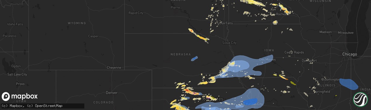
Wind
Hail
Tornado
7,092
Estimated number of impacted properties by a 1.00" hail or larger444
Estimated number of impacted properties by a 1.75" hail or larger0
Estimated number of impacted properties by a 2.50" hail or largerStorm reports in Nebraska
Nebraska
| Date | Description |
|---|---|
| 07/31/20246:43 PM CDT | A local report indicates 58 MPH wind near 1 NE Murray |
| 07/31/20246:08 PM CDT | A local report indicates 90 MPH wind near 7 ENE Omaha |
| 07/31/20246:05 PM CDT | A local report indicates 87 MPH wind near 7 ENE Omaha |
| 07/31/20246:02 PM CDT | Downed power line in road at maple and 70th circle. |
| 07/31/20245:59 PM CDT | A local report indicates 59 MPH wind near 3 SSE Plattsmouth |
| 07/31/20245:54 PM CDT | A local report indicates 90 MPH wind near 1 S Washington |
| 07/31/20245:51 PM CDT | Large store front awning or facade completely destroyed at 90th and maple. Time estimated from radar. |
| 07/31/20245:51 PM CDT | Brief tornado near missouri river. |
| 07/31/20245:50 PM CDT | A local report indicates 68 MPH wind near 1 W Omaha |
| 07/31/20245:48 PM CDT | A local report indicates 89 MPH wind near Louisville |
| 07/31/20245:44 PM CDT | A local report indicates 77 MPH wind near 2 E Elkhorn |
| 07/31/20245:43 PM CDT | A local report indicates 80 MPH wind near 2 SW Papillion |
| 07/31/20245:42 PM CDT | Roof blown off of commercial building. |
| 07/31/20245:37 PM CDT | Highest gust at nws omaha office. |
| 07/31/20245:36 PM CDT | A local report indicates 59 MPH wind near 1 E Louisville |
| 07/31/20245:34 PM CDT | Picture on twitter shows power poles snapped on highway 50 north of springfield. Time estimated from radar. |
| 07/31/20245:32 PM CDT | Report of part of roof off of house and multiple broken windows. Time estimated based off radar. |
| 07/31/20245:32 PM CDT | A local report indicates 75 MPH wind near 3 W Millard |
| 07/31/20245:19 PM CDT | A local report indicates 66 MPH wind near 3 WSW Murdock |
| 07/31/20245:08 PM CDT | A local report indicates 67 MPH wind near 3 SSW Davey |
| 07/31/20245:07 PM CDT | A local report indicates 67 MPH wind near 2 SSW Greenwood |
| 07/31/20245:05 PM CDT | Roof damage to a hotel near the airport. |
| 07/31/20245:04 PM CDT | Max observed wind at the lincoln airport. |
| 07/31/20245:03 PM CDT | A local report indicates 76 MPH wind near 1 SSE Davey |
| 07/31/20245:02 PM CDT | A local report indicates 79 MPH wind near 4 WNW Lincoln |
| 07/31/20244:57 PM CDT | A local report indicates 60 MPH wind near 1 NE Hickman |
| 07/31/20244:57 PM CDT | A local report indicates 59 MPH wind near 4 W Ceresco |
| 07/31/20244:56 PM CDT | A local report indicates 88 MPH wind near 4 NW Martell |
| 07/31/20244:54 PM CDT | Estimated 70 mph. Numerous trees down. |
| 07/31/20244:51 PM CDT | A local report indicates 63 MPH wind near 4 WNW Lincoln |
| 07/31/20244:48 PM CDT | A local report indicates 70 MPH wind near 4 ESE Raymond |
| 07/31/20244:48 PM CDT | A local report indicates 75 MPH wind near 4 SE Malcolm |
| 07/31/20244:47 PM CDT | A local report indicates 74 MPH wind near 2 WNW Lincoln |
| 07/31/20244:43 PM CDT | A local report indicates 92 MPH wind near 1 SW Denton |
| 07/31/20244:42 PM CDT | Power line down and a large tree down on the road. |
| 07/31/20244:40 PM CDT | A local report indicates 1.00 inch wind near Bruning |
| 07/31/20244:29 PM CDT | Personal weather station measurement. |
| 07/31/20244:20 PM CDT | Measured on a personal weather station. |
| 07/31/20244:20 PM CDT | Estimated 50-60 mph winds. |
| 07/31/20244:06 PM CDT | Primarily nickels with a few ping pong balls. |
| 07/31/20244:01 PM CDT | Facebook report of nickel to quarter size hail. |
| 07/31/20243:50 PM CDT | A local report indicates 1.75 inch wind near Hollinger |
| 07/31/20243:48 PM CDT | Tree limbs down. |
| 07/31/20243:47 PM CDT | Large tree limbs down on property. Hail as well but exact size not known. Very heavy rain. |
| 07/31/20243:40 PM CDT | Facebook photo of hail right at quarter size. |
| 07/31/20243:38 PM CDT | A local report indicates 1.00 inch wind near 4 S Arapahoe |
| 07/31/20243:24 PM CDT | Mostly nickel sized with a few quarters. |
| 07/31/202412:17 PM CDT | A local report indicates 59 MPH wind near Ord Airport |
| 07/31/202411:46 AM CDT | Nebraska mesonet site. Time used from nearby asos gust time. |
| 07/31/202411:46 AM CDT | Corrects speed of previous tstm wnd gst report from ord airport. |
| 07/31/202411:41 AM CDT | A local report indicates 59 MPH wind near 4 WSW Ord |
| 07/31/202411:35 AM CDT | A local report indicates 60 MPH wind near 8 WSW Ord |
| 07/30/20248:28 PM CDT | A local report indicates 2.00 inch wind near 8 S Monowi |
| 07/30/20248:15 PM CDT | A local report indicates 1.75 inch wind near 5 SSE Lynch |
| 07/30/20248:12 PM CDT | A local report indicates 1.75 inch wind near 5 SW Lynch |
| 07/30/20247:55 PM CDT | A local report indicates 1.00 inch wind near 2 SW Spencer |
All States Impacted by Hail Map on July 31, 2024
Cities Impacted by Hail Map on July 31, 2024
- Unionville, IA
- Moravia, IA
- Novinger, MO
- Manito, IL
- Forest City, IL
- Topeka, IL
- Greentop, MO
- Queen City, MO
- Byron, IL
- Oregon, IL
- Leaf River, IL
- Kirksville, MO
- Memphis, MO
- Eagle Butte, SD
- Wenona, IL
- Stillman Valley, IL
- Downing, MO
- Brashear, MO
- Chana, IL
- Streator, IL
- Colchester, IL
- Hamilton, IL
- Warsaw, IL
- Milan, MO
- Plymouth, IL
- Macomb, IL
- Mandan, ND
- Flanagan, IL
- Littleton, IL
- Industry, IL
- Bismarck, ND
- Oskaloosa, IA
- El Paso, IL
- Tennessee, IL
- Davis Junction, IL
- Rochelle, IL
- Long Point, IL
- Green City, MO
- Chenoa, IL
- Baring, MO
- Pontiac, IL
- Green Castle, MO
- Meadow, SD
- Odell, IL
- Menoken, ND
- Gettysburg, SD
- Shannon City, IA
- Sterling, ND
- Strawn, IL
- Sibley, IL
- Saybrook, IL
- Fairbury, IL
- Rushville, IL
- Murray, IA
- Colfax, IL
- Gibson City, IL
- Cropsey, IL
- Osceola, IA
- Tuttle, ND
- Robinson, ND
- Anchor, IL
- Penfield, IL
- Gifford, IL
- Chariton, IA
- Paxton, IL
- Melvin, IL
- Knoxville, IA
- Thayer, IA
- Ellston, IA
- Rantoul, IL
- Ludlow, IL
- Hoven, SD
- Tolstoy, SD
- Onaka, SD
- Woodworth, ND
- Harvey, IA
- Ottumwa, IA
- Blakesburg, IA
- Albia, IA
- Newman, IL
- Weldon, IA
- Russell, IA
- Urbana, IL
- Tolono, IL
- Saint Joseph, IL
- Philo, IL
- Chambersburg, IL
- Potomac, IL
- Armstrong, IL
- Rankin, IL
- Melrose, IA
- Sykeston, ND
- Ogden, IL
- Griggsville, IL
- New Salem, IL
- Baylis, IL
- Sidney, IL
- Broadlands, IL
- Carrington, ND
- Pella, IA
- Leighton, IA
- Tracy, IA
- Eddyville, IA
- Hume, IL
- Allerton, IL
- Homer, IL
- Brocton, IL
- Fithian, IL
- Collison, IL
- Barry, IL
- Pittsfield, IL
- Seneca, SD
- Faulkton, SD
- Cresbard, SD
- Chrisman, IL
- Metcalf, IL
- Hamilton, IA
- Bowdon, ND
- Drakesville, IA
- Lacona, IA
- Rockport, IL
- Indianola, IL
- Sidell, IL
- Paris, IL
- Bloomfield, IA
- Elliott, IL
- Foosland, IL
- Fisher, IL
- Loda, IL
- Dewey, IL
- Thomasboro, IL
- Champaign, IL
- Royal, IL
- Hoopeston, IL
- Rossville, IL
- Henning, IL
- Tilton, IL
- Alvin, IL
- Westville, IL
- Georgetown, IL
- Danville, IL
- Fairmount, IL
- Catlin, IL
- Oakwood, IL
- Muncie, IL
- Covington, IN
- Veedersburg, IN
- Attica, IN
- Ambia, IN
- Waynetown, IN
- Cayuga, IN
- Williamsport, IN
- State Line, IN
- Perrysville, IN
- Mellott, IN
- Newtown, IN
- Wingate, IN
- West Lebanon, IN
- Bismarck, IL
- Kingman, IN
- Hillsboro, IN
- Ridge Farm, IL
- Dana, IN
- Ipswich, SD
- Columbia, IA
- Crawfordsville, IN
- Alamo, IN
- Marshall, IN
- Bloomingdale, IN
- Humeston, IA
- Promise City, IA
- Woodburn, IA
- Aberdeen, SD
- Seymour, IA
- Corydon, IA
- Maywood, NE
- Hayes Center, NE
- Wellfleet, NE
- New Rockford, ND
- Keosauqua, IA
- Centerville, IA
- Plano, IA
- Mystic, IA
- Andover, SD
- Edgeley, ND
- Williamson, IA
- Lovilia, IA
- Sullivan, IL
- Bethany, IL
- Milton, IA
- Cantril, IA
- Argyle, IA
- Ypsilanti, ND
- Maxwell, NE
- Alexandria, MO
- Curtis, NE
- Groton, SD
- Pulaski, IA
- Udell, IA
- Marion, ND
- Berlin, ND
- Dickey, ND
- Exline, IA
- Moulton, IA
- Columbia, SD
- Bath, SD
- Amherst, SD
- Claremont, SD
- Langford, SD
- Moorefield, NE
- Webster, SD
- Bristol, SD
- Spiritwood, ND
- Litchville, ND
- Brady, NE
- Mattoon, IL
- Jamestown, ND
- Stratford, SD
- Conde, SD
- Ferney, SD
- Pierpont, SD
- Roslyn, SD
- Britton, SD
- Lancaster, MO
- Coatsville, MO
- Arbela, MO
- Sanborn, ND
- Wimbledon, ND
- Farnam, NE
- Eden, SD
- Waubay, SD
- Grenville, SD
- Veblen, SD
- Lake City, SD
- Springville, IN
- Bedford, IN
- Bloomington, IN
- Kathryn, ND
- Rogers, ND
- Gothenburg, NE
- Cozad, NE
- Luray, MO
- Mount Sterling, IA
- Florence, SD
- Cincinnati, IA
- Wilmot, SD
- Peever, SD
- Sisseton, SD
- Summit, SD
- Ortley, SD
- Ord, NE
- Comstock, NE
- Elyria, NE
- Claire City, SD
- Ericson, NE
- Scotia, NE
- Lidgerwood, ND
- South Shore, SD
- Twin Brooks, SD
- Marvin, SD
- Heltonville, IN
- Forman, ND
- Willow Island, NE
- Corona, SD
- New Effington, SD
- Hankinson, ND
- Beardsley, MN
- Milbank, SD
- Browns Valley, MN
- Willow Hill, IL
- Newton, IL
- Oblong, IL
- Havana, ND
- Yale, IL
- Rutledge, MO
- Watertown, SD
- Ortonville, MN
- Clinton, MN
- Fairmount, ND
- Rosholt, SD
- Wheaton, MN
- Graceville, MN
- Dumont, MN
- Mount Sterling, IL
- Dahlgren, IL
- Gorin, MO
- Dundas, IL
- Claremont, IL
- Robinson, IL
- Olney, IL
- Sumner, IL
- Lexington, NE
- Bardstown, KY
- Tintah, MN
- Wahpeton, ND
- Campbell, MN
- Barry, MN
- Wyaconda, MO
- Flat Rock, IL
- Mantador, ND
- Wyndmere, ND
- Brownstown, IN
- Stockholm, SD
- Bridgeport, IL
- Breckenridge, MN
- Donnelly, MN
- Nashua, MN
- Elbow Lake, MN
- Norcross, MN
- Herman, MN
- Kahoka, MO
- Williamstown, MO
- Saint Patrick, MO
- Buxton, ND
- Cummings, ND
- Campbellsburg, IN
- Vallonia, IN
- Lawrenceville, IL
- Springerton, IL
- Oaktown, IN
- Wendell, MN
- Foxhome, MN
- Chokio, MN
- Paoli, IN
- Big Stone City, SD
- Bellingham, MN
- Hillsboro, ND
- Caledonia, ND
- Montezuma, GA
- La Belle, MO
- Monticello, MO
- Canton, MO
- Moorhead, MN
- Salem, IN
- Quincy, IL
- French Lick, IN
- West Baden Springs, IN
- Hardinsburg, IN
- Sabin, MN
- Comstock, MN
- Fowler, IL
- Correll, MN
- Odessa, MN
- Charlestown, IN
- Rothsay, MN
- Fergus Falls, MN
- Barrett, MN
- Hoffman, MN
- Morris, MN
- Ashby, MN
- Dalton, MN
- Elizabeth, MN
- Carmi, IL
- Memphis, IN
- Henryville, IN
- Stockville, NE
- Pekin, IN
- Liberty, IL
- Payson, IL
- Scottsburg, IN
- Jeffersonville, IN
- Prospect, KY
- Appleton, MN
- Barnesville, MN
- Underwood, IN
- Ferdinand, IN
- Thief River Falls, MN
- Plainville, IL
- Holloway, MN
- Hancock, MN
- Cannelburg, IN
- Loogootee, IN
- Clayton, IL
- Louisville, KY
- Borden, IN
- Mitchell, IN
- Ulen, MN
- Benson, MN
- Clontarf, MN
- McCook, NE
- Indianola, NE
- Funk, NE
- Danvers, MN
- Glennville, GA
- Orleans, IN
- Sellersburg, IN
- Floyds Knobs, IN
- Cordele, GA
- Waubun, MN
- Campbell, NE
- Glenwood, MN
- Bartley, NE
- Reidsville, GA
- Wood River, NE
- Murdock, MN
- Doniphan, NE
- Sunburg, MN
- Pennock, MN
- Simpsonville, KY
- Taylorsville, KY
- Fisherville, KY
- Cambridge, NE
- Holbrook, NE
- Wilsonville, NE
- Arapahoe, NE
- Beaver City, NE
- Hendley, NE
- Blue Hill, NE
- Guide Rock, NE
- Lawrence, NE
- Geneva, NE
- Sutton, NE
- Coxs Creek, KY
- Mount Washington, KY
- Alda, NE
- Edison, NE
- Oxford, NE
- Deweese, NE
- Nelson, NE
- New Hope, KY
- Loretto, KY
- New Haven, KY
- Springfield, KY
- Grafton, NE
- Hodgenville, KY
- Sonora, KY
- Lebanon, KY
- Naytahwaush, MN
- Bedford, KY
- Vevay, IN
- Madison, IN
- Milton, KY
- Carrollton, KY
- Lebanon, NE
- Almena, KS
- Long Island, KS
- Prairie View, KS
- Phillipsburg, KS
- Edgar, NE
- Warroad, MN
- Strathcona, MN
- Fairmont, NE
- Campbellsville, KY
- Buffalo, KY
- Grinnell, KS
- Hill City, KS
- Milligan, NE
- Exeter, NE
- Friend, NE
- Beaver Crossing, NE
- Dorchester, NE
- Milford, NE
- Crete, NE
- Trumbull, NE
- Hastings, NE
- Inland, NE
- Brainerd, MN
- Raywick, KY
- Bagley, MN
- Mahnomen, MN
- Glenvil, NE
- Fairfield, NE
- Holdrege, NE
- Broxton, GA
- Denton, GA
- Jacksonville, GA
- Pierz, MN
- Gove, KS
- Grainfield, KS
- Glade, KS
- Seward, NE
- Pleasant Dale, NE
- Lenora, KS
- Shickley, NE
- Strang, NE
- Worthville, KY
- Sanders, KY
- Jonesboro, GA
- Norton, KS
- Lenox, GA
- Tifton, GA
- Bladen, NE
- Stamford, NE
- Norcatur, KS
- Dawson, GA
- Hoxie, KS
- Quinter, KS
- Park, KS
- Orleans, NE
- Alma, NE
- Agra, KS
- Kirwin, KS
- Kensington, KS
- Penokee, KS
- Bogue, KS
- Stockton, KS
- Damar, KS
- Carleton, NE
- Bruning, NE
- Alexandria, NE
- Denton, NE
- Lincoln, NE
- Malcolm, NE
- Raymond, NE
- Davey, NE
- Ceresco, NE
- Martell, NE
- Ohiowa, NE
- Hallam, NE
- Hickman, NE
- Sprague, NE
- Roca, NE
- Valparaiso, NE
- Ambrose, GA
- Wray, GA
- Emily, MN
- Pequot Lakes, MN
- Cosmos, MN
- Hutchinson, MN
- Sacred Heart, MN
- Granite Falls, MN
- Echo, MN
- Kimball, MN
- Aitkin, MN
- Magnolia, KY
- New London, MN
- Atwater, MN
- Litchfield, MN
- Grove City, MN
- Starbuck, MN
- Minneapolis, MN
- Hopkins, MN
- Logan, KS
- Grantville, GA
- Hogansville, GA
- Greenville, GA
- Morland, KS
- Collyer, KS
- Pearl, IL
- Butler, GA
- Mount Sherman, KY
- South Haven, MN
- Culloden, GA
- Gaylord, KS
- Cedar, KS
- Athol, KS
- Adams, NE
- Walton, NE
- Panama, NE
- Bennet, NE
- Palmyra, NE
- Waverly, NE
- South Saint Paul, MN
- Saint Paul, MN
- Greensburg, KY
- Summersville, KY
- Republican City, NE
- Davenport, NE
- Climax, GA
- Wayzata, MN
- Eatonton, GA
- Sparks, GA
- Smith Center, KS
- Portis, KS
- Ashland, NE
- Greenwood, NE
- Eagle, NE
- Douglas, NE
- Fremont, NE
- Colon, NE
- Ithaca, NE
- Alvo, NE
- Valley, NE
- Yutan, NE
- Memphis, NE
- Mead, NE
- Wahoo, NE
- Elmwood, NE
- Suitland, MD
- Temple Hills, MD
- Oxon Hill, MD
- Upper Marlboro, MD
- District Heights, MD
- Andrews Air Force Base, MD
- Clinton, MD
- Fort Washington, MD
- Brandywine, MD
- Cheltenham, MD
- Smyrna, DE
- Townsend, DE
- Savannah, GA
- Wilcox, NE
- Newton, GA
- Alberta, MN
- Byron, GA
- Henderson, NE
- Damascus, GA
- Arlington, GA
- Royalton, MN
- Hereford, TX
- Renville, MN
- Ayr, NE
- Eden Prairie, MN
- Alexandria, VA
- McLean, VA
- Omer, MI
- Mount Rainier, MD
- Washington, DC
- Bethesda, MD
- Chevy Chase, MD
- Hyattsville, MD
- Arlington, VA
- Brentwood, MD
- Takoma Park, MD
- Middletown, DE
- Danube, MN
- Olivia, MN
- Bird Island, MN
- Unadilla, NE
- Waterloo, NE
- Burr, NE
- Weeping Water, NE
- Gretna, NE
- Avoca, NE
- Syracuse, NE
- Murdock, NE
- Elkhorn, NE
- Omaha, NE
- South Bend, NE
- Springfield, NE
- Louisville, NE
- Otoe, NE
- Washington, NE
- Bennington, NE
- Manley, NE
- Arlington, NE
- Blair, NE
- Kennard, NE
- Bellevue, NE
- Fort Calhoun, NE
- Papillion, NE
- La Vista, NE
- Crescent, IA
- Honey Creek, IA
- Murray, NE
- Dunbar, NE
- Carter Lake, IA
- Boys Town, NE
- Nehawka, NE
- Plattsmouth, NE
- Cedar Creek, NE
- Missouri Valley, IA
- Wakeeney, KS
- Alton, KS
- Thomasville, GA
- Garland, NE
- Mays Landing, NJ
- Hammonton, NJ
- Redwood Falls, MN
- Vienna, VA
- Dunn Loring, VA
- Falls Church, VA
- Annandale, VA
- Fairfax, VA
- Lanham, MD
- Capitol Heights, MD
- Kensington, MN
- Farwell, MN
- Downs, KS
- Esbon, KS
- Mankato, KS
- Beloit, KS
- Jamestown, KS
- Concordia, KS
- Leary, GA
- Hamel, MN
- Loretto, MN
- Glencoe, MN
- Plato, MN
- Osborne, KS
- Minnetonka, MN
- Silver Spring, MD
- Stinnett, TX
- Giltner, NE
- Harvard, NE
- Woodston, KS
- Randall, KS
- Jewell, KS
- Fredericksburg, OH
- Apple Creek, OH
- Long Lake, MN
- Northfield, MN
- Lester Prairie, MN
- Morton, MN
- Grasston, MN
- Norway, KS
- Council Bluffs, IA
- Modale, IA
- Neola, IA
- Underwood, IA
- Woodbine, IA
- Pisgah, IA
- Offutt Afb, NE
- Logan, IA
- Magnolia, IA
- Mondamin, IA
- Alexandria, MN
- Lowry, MN
- Hector, MN
- Pacific Junction, IA
- Stewart, MN
- Buffalo Lake, MN
- Silver City, IA
- Persia, IA
- Treynor, IA
- Minden, IA
- Mineola, IA
- Glenwood, IA
- McClelland, IA
- Shelby, IA
- Gibbon, MN
- Winthrop, MN
- Fairfax, MN
- Union, NE
- Nebraska City, NE
- Thurman, IA
- Percival, IA
- Portsmouth, IA
- Tabor, IA
- Dunlap, IA
- Hancock, IA
- Macedonia, IA
- Hastings, IA
- Avoca, IA
- Essex, IA
- Oakland, IA
- Henderson, IA
- Malvern, IA
- Carson, IA
- Red Oak, IA
- Imogene, IA
- Emerson, IA
- Panama, IA
- Farragut, IA
- Randolph, IA
- Coin, IA
- Sidney, IA
- Hamburg, IA
- Riverton, IA
- Shenandoah, IA
- Clarinda, IA
- Harlan, IA
- Elliott, IA
- Stanton, IA
- New Market, IA
- Yorktown, IA
- Griswold, IA
- Villisca, IA
- Brownton, MN
- Farmington, MN
- Clayton, AL
- Eufaula, AL
- Glen Elder, KS
- Franklin, MN
- Georgetown, GA
- Champlin, MN
- Anoka, MN
- Dwight, NE
- Bee, NE
- Inavale, NE
- Wyoming, MN
- Ogallah, KS
- Glasco, KS
- Luck, WI
- Centuria, WI
- Saint Croix Falls, WI
- Ocala, FL
- Summerfield, FL
- Roberta, GA
- Bradley, SD
- Cyrus, MN
- Ransom, KS
- Musella, GA
- Cannon Falls, MN
- Randolph, MN
- Springfield, VA
- Absecon, NJ
- Arlington, MN
- Harwood, MD
- Lothian, MD
- Gaylord, MN
- Henderson, MN
- Le Sueur, MN
- Nelson, MN
- Lakeville, MN
- Hastings, MN
- Delphos, KS
- Aurora, KS
- Webster, MN
- Dennison, MN
- Belle Plaine, MN
- Villard, MN
- Utica, KS
- New Middletown, IN
- Corydon, IN
- Weston, NE
- Elko New Market, MN
- Lonsdale, MN
- Naponee, NE
- Goodhue, MN
- Red Wing, MN
- Welch, MN
- Ellis, KS
- Brownell, KS
- Gregory, SD
- Burke, SD
- Herrick, SD
- Saint Charles, SD
- McCracken, KS
- Hays, KS
- Bazine, KS
- Garfield, MN
- Brandon, MN
- Belleview, FL
- Strandburg, SD
- Elizabeth, IN
- Miltonvale, KS
- Osakis, MN
- Clyde, KS
- Marne, IA
- Lewis, IA
- Walnut, IA
- Atlantic, IA
- Cumberland, IA
- Grant, IA
- Nodaway, IA
- Earling, IA
- Gravity, IA
- Corning, IA
- Carbon, IA
- Irwin, IA
- Audubon, IA
- Wiota, IA
- Exira, IA
- Defiance, IA
- Elk Horn, IA
- Kirkman, IA
- Brayton, IA
- Kimballton, IA
- Bridgewater, IA
- Massena, IA
- Westphalia, IA
- Alexander, KS
- Lake City, MN
- Mazeppa, MN
- Zumbro Falls, MN
- Saint Peter, MN
- Kasota, MN
- Castlewood, SD
- Boyd, MN
- Montevideo, MN
- Dawson, MN
- Zumbrota, MN
- Kranzburg, SD
- Goodwin, SD
- Faribault, MN
- Clay Center, KS
- Tescott, KS
- Blanchard, IA
- Brookville, KS
- Newville, AL
- Midland City, AL
- Ozark, AL
- Cleveland, MN
- Madison Lake, MN
- Bunker Hill, KS
- Russell, KS
- Sylvan Grove, KS
- Dorrance, KS
- Lincoln, KS
- Lucas, KS
- Luray, KS
- Beverly, KS
- Barnard, KS
- Wilson, KS
- Ellsworth, KS
- Salina, KS
- Minneapolis, KS
- Lindsborg, KS
- Assaria, KS
- Bennington, KS
- Prescott, IA
- Lenox, IA
- Sharpsburg, IA
- Clearfield, IA
- Diagonal, IA
- Fontanelle, IA
- Anita, IA
- Creston, IA
- Bedford, IA
- Orient, IA
- Adair, IA
- Greenfield, IA
- Cromwell, IA
- Casey, IA
- Hamlin, IA
- Guthrie Center, IA
- Stuart, IA
- Menlo, IA
- Bonesteel, SD
- Braddyville, IA
- Clarkfield, MN
- Watson, MN
- Shambaugh, IA
- Hopkins, MO
- Clearmont, MO
- Clear Lake, SD
- La Crosse, KS
- Ness City, KS
- Nekoma, KS
- Madison, MN
- College Springs, IA
- Carlos, MN
- Elberton, GA
- Friona, TX
- Leonardtown, MD
- Maynard, MN
- Elysian, MN
- Bridgewater, SD
- Bison, KS
- Rush Center, KS
- Janesville, MN
- Le Center, MN
- Liebenthal, KS
- Millville, MN
- Sunray, TX
- Burdett, KS
- Rozel, KS
- Woodbine, KS
- Ramona, KS
- Tampa, KS
- New Cambria, KS
- Solomon, KS
- Chapman, KS
- Hope, KS
- Abilene, KS
- Enterprise, KS
- Gypsum, KS
- Herington, KS
- Longford, KS
- Talmage, KS
- Earlham, IA
- Dexter, IA
- Winterset, IA
- Adel, IA
- Redfield, IA
- Peru, IA
- Saint Charles, IA
- Benton, IA
- Blockton, IA
- Mount Ayr, IA
- Tingley, IA
- Kellerton, IA
- Nerstrand, MN
- Hanston, KS
- Clara City, MN
- Emery, SD
- Olivet, SD
- Parkston, SD
- Waterville, MN
- Sheridan, MO
- Albert, KS
- Olmitz, KS
- Otis, KS
- Good Thunder, MN
- Erwin, SD
- Morganville, KS
- Elgin, MN
- Rochester, MN
- De Smet, SD
- Alexandria, SD
- Kellogg, MN
- Plainview, MN
- Schoenchen, KS
- Larned, KS
- Pfeifer, KS
- Hoisington, KS
- Great Bend, KS
- Pawnee Rock, KS
- Spencer, NE
- Bristow, NE
- Lynch, NE
- St John, KS
- Van Meter, IA
- De Soto, IA
- Waukee, IA
- Dallas Center, IA
- Booneville, IA
- West Des Moines, IA
- Cumming, IA
- Prole, IA
- Norwalk, IA
- Patterson, IA
- Hartwell, GA
- Carthage, SD
- Butte, NE
- Fairfax, SD
- Wood Lake, MN
- Belview, MN
- Waseca, MN
- Owatonna, MN
- Willmar, MN
- Kenyon, MN
- Wakefield, KS
- Gorham, KS
- Ashford, AL
- Columbia, AL
- Headland, AL
- Canistota, SD
- Bruce, SD
- Brookings, SD
- Clopton, AL
- Abbeville, AL
- Indianola, IA
- Bevington, IA
- Johnston, IA
- Martensdale, IA
- Des Moines, IA
- Urbandale, IA
- Ankeny, IA
- Clive, IA
- Windsor Heights, IA
- Grimes, IA
- Carlisle, IA
- Polk City, IA
- Riley, KS
- Spencer, SD
- Oneill, NE
- Salem, SD
- Canova, SD
- Stockbridge, GA
- Hampton, GA
- Alma, GA
- Kandiyohi, MN
- Lake Lillian, MN
- Pine Island, MN
- Ivanhoe, MN
- White, SD
- Taunton, MN
- Estelline, SD
- Winfred, SD
- Madison, SD
- White City, KS
- Junction City, KS
- Milford, KS
- Manhattan, KS
- Ogden, KS
- Fort Riley, KS
- Verdigre, NE
- Niobrara, NE
- Vienna, SD
- Hayti, SD
- Lamberton, MN
- Storden, MN
- Mitchell, SD
- Eyota, MN
- Pemberton, MN
- Mapleton, MN
- Bryant, SD
- Bladensburg, MD
- Fedora, SD
- Howard, SD
- Artesian, SD
- Riverdale, MD
- Paradise, KS
- Westbrook, MN
- Kinsley, KS
- Oldham, SD
- Arlington, SD
- Ramona, SD
- Lynd, MN
- Arco, MN
- Russell, MN
- Pleasant Hill, IA
- Bondurant, IA
- Berwick, IA
- Elkhart, IA
- Mitchellville, IA
- Prairie City, IA
- Runnells, IA
- Collins, IA
- Maxwell, IA
- Altoona, IA
- Colfax, IA
- Mingo, IA
- Hartford, IA
- Swan, IA
- Olsburg, KS
- Saint George, KS
- Wilsey, KS
- Dwight, KS
- Alta Vista, KS
- Alma, KS
- Council Grove, KS
- Westmoreland, KS
- Baxter, IA
- Wamego, KS
- Natoma, KS
- Clio, AL
- Rosemount, MN
- Onaga, KS
- Belvue, KS
- McFarland, KS
- Paxico, KS
- Eskridge, KS
- Maple Hill, KS
- Harveyville, KS
- Saint Marys, KS
- Dover, MN
- Saint Charles, MN
- Altura, MN
- Sanborn, MN
- Jeffers, MN
- Iroquois, SD
- Northboro, IA
- Garfield, KS
- Waldorf, MN
- Gallatin, MO
- Winnetoon, NE
- Creighton, NE
- Minnesota Lake, MN
- Fulton, SD
- Hope, MN
- Ellendale, MN
- Havensville, KS
- Soldier, KS
- Comfrey, MN
- Delia, KS
- Emmett, KS
- Springfield, MN
- Bingham Lake, MN
- Berryton, KS
- Scranton, KS
- Wakarusa, KS
- Carbondale, KS
- Burlingame, KS
- Quenemo, KS
- Rossville, KS
- Topeka, KS
- Pomona, KS
- Auburn, KS
- Silver Lake, KS
- Overbrook, KS
- Baldwin City, KS
- Ottawa, KS
- Perry, KS
- Grantville, KS
- Muscotah, KS
- Effingham, KS
- Lecompton, KS
- Lawrence, KS
- Denison, KS
- Nortonville, KS
- Whiting, KS
- Oskaloosa, KS
- Hoyt, KS
- Meriden, KS
- Tecumseh, KS
- Holton, KS
- Ozawkie, KS
- Valley Falls, KS
- Mayetta, KS
- Horton, KS
- Circleville, KS
- Lorraine, KS
- Kanopolis, KS
- Geneseo, KS
- Marquette, KS
- Falun, KS
- Durham, KS
- Jamesport, MO
- Mountain Lake, MN
- Rosendale, MO
- Blooming Prairie, MN
- Claremont, MN
- Lost Springs, KS
- Lincolnville, KS
- Winchester, KS
- Wellsville, KS
- McLouth, KS
- Eudora, KS
- Tonganoxie, KS
- Cummings, KS
- Everest, KS
- Atchison, KS
- Lancaster, KS
- Bronwood, GA
- Leesburg, GA
- Butterfield, MN
- New Liberty, KY
- Owenton, KY
- Blomkest, MN
- Raymond, MN
- Garden City, MN
- Madelia, MN
- Lake Crystal, MN
- Minnesota City, MN
- Fort Valley, GA
- Rea, MO
- Bolckow, MO
- Burdick, KS
- Easton, KS
- Rushville, MO
- Leavenworth, KS
- Linwood, KS
- Texico, NM
- Guilford, MO
- Clifton, KS
- Gilman City, MO
- Garvin, MN
- Balaton, MN
- Fairmont, MN
- Welcome, MN
- De Soto, KS
- Olathe, KS
- Edgerton, KS
- Gardner, KS
- Emporia, KS
- Strong City, KS
- Platte City, MO
- Fort Leavenworth, KS
- Basehor, KS
- Lansing, KS
- Kansas City, KS
- De Kalb, MO
- Bonner Springs, KS
- Weston, MO
- Faucett, MO
- Agency, MO
- Wathena, KS
- Saint Joseph, MO
- Dearborn, MO
- Bendena, KS
- Troy, KS
- Netawaka, KS
- Denton, KS
- Elwood, KS
- Amazonia, MO
- Oregon, MO
- Savannah, MO
- Cosby, MO
- Easton, MO
- Farley, MO
- Lenexa, KS
- Camden Point, MO
- New Century, KS
- Kansas City, MO
- Shawnee, KS
- Waldron, MO
- Allen, KS
- Center, NE
- Saint James, MN
- West Concord, MN
- Lewisville, MN
- Ellinwood, KS
- Brooklyn, IA
- Smithville, MO
- Riverside, MO
- Prairie Village, KS
- Edgerton, MO
- Stewartsville, MO
- Union Star, MO
- Mission, KS
- Clarksdale, MO
- Helena, MO
- King City, MO
- Trimble, MO
- Amity, MO
- Gower, MO
- Leawood, KS
- Overland Park, KS
- Marion, SD
- Scotland, SD
- Marengo, IA
- Montezuma, IA
- Forest City, IA
- Britt, IA
- Garner, IA
- Crystal Lake, IA
- Statesville, NC
- Menno, SD
- Lesterville, SD
- Windom, MN
- Liberty, MO
- Kearney, MO
- Grandview, MO
- Lafayette, MN
- Lees Summit, MO
- Independence, MO
- Lawson, MO
- Missouri City, MO
- Plattsburg, MO
- Greenwood, MO
- Lathrop, MO
- Blue Springs, MO
- Holt, MO
- Excelsior Springs, MO
- Osborn, MO
- Maysville, MO
- Turney, MO
- Cameron, MO
- New Richland, MN
- Kingman, KS
- Parker, SD
- Rollingstone, MN
- Buckner, MO
- Orrick, MO
- Sibley, MO
- Polo, MO
- Grain Valley, MO
- Novelty, MO
- Edina, MO
- Ainsworth, IA
- Delavan, MN
- Lone Tree, IA
- Cedar Rapids, IA
- Palo, IA
- Webb, AL
- Humboldt, SD
- Cheney, KS
- Murdock, KS
- Fairfax, IA
- Norway, IA
- Oak Grove, MO
- Lone Jack, MO
- Levasy, MO
- Mayview, MO
- Richmond, MO
- Bates City, MO
- Odessa, MO
- Wellington, MO
- Henrietta, MO
- Camden, MO
- Napoleon, MO
- Lexington, MO
- Rayville, MO
- Hardin, MO
- Kingston, MO
- Cowgill, MO
- Kidder, MO
- Weatherby, MO
- Hamilton, MO
- Altamont, MO
- Hudson, KS
- Hartford, SD
- Shellsburg, IA
- Fort Stockton, TX
- Winona, MN
- Easton, MN
- Wells, MN
- Danville, IA
- Fountain City, WI
- Osage City, KS
- West Burlington, IA
- Macon, MO
- Wichita, KS
- Glenville, MN
- Ionia, IA
- Charles City, IA
- Lyndon, KS
- Atkins, IA
- Tyndall, SD
- Anabel, MO
- Clarence, MO
- Abbyville, KS
- Swainsboro, GA
- Midville, GA
- Derby, KS
- Mcconnell Afb, KS
- Watkins, IA
- Milledgeville, GA
- Monticello, KY
- Chillicothe, MO
- Albany, MO
- Partridge, KS
- Hutchinson, KS
- Lyle, MN
- Northwood, IA
- Nickerson, KS
- Garnett, KS
- Gerlaw, IL
- Alexis, IL
- Bainbridge, GA
- Fort Ripley, MN
- Blue Grass, IA
- Walcott, IA
- Stafford, KS
- Osseo, MN
- Austin, MN
- Purdin, MO
- Linneus, MO
- Burrton, KS
- Lawler, IA
- Cresco, IA
- Haven, KS
- Pecos, TX
- Albert Lea, MN
- Marysville, KS
- Callao, MO
- Brookfield, MO
- Fort Atkinson, IA
- Calmar, IA
- Spillville, IA
- Davenport, IA
- Coal Valley, IL
- Saint Ansgar, IA
- Sherrard, IL
- Milan, IL
- Moline, IL
- Rock Island, IL
- Mount Hope, KS
- Orion, IL
- Bevier, MO
- Sedgwick, KS
- Colwich, KS
- Rose Creek, MN
- Ridgeway, IA
- Ossian, IA
- Decorah, IA
- Solway, MN
- Little Falls, MN
- Andover, KS
- Tompkinsville, KY
- Ellisville, IL
- Smithfield, IL
- Merrifield, MN
- Swatara, MN
- Grand Rapids, MN
- Bovey, MN
- Bigfork, MN
- Onamia, MN
- Garrison, MN
- Hill City, MN
- Palisade, MN
- Cuba, IL
- Canton, IL
- Rockford, MN
- Buffalo, MN
- Annandale, MN
- Maple Lake, MN
- Pine City, MN
- Maple Grove, MN
- Nogales, AZ
- Orr, MN
- Knox City, MO
- Newark, MO
- Imperial, TX
- Shelbyville, MO
- Lentner, MO
- Shelbina, MO
- Marshall, MO
- Atlanta, MO
- Lewistown, IL
- Virginia, IL
- Beardstown, IL
- Port Byron, IL
- Liverpool, IL
- Frederick, IL
- Havana, IL
- Chandlerville, IL
- Jacksonville, IL
- Bath, IL
- Arenzville, IL
- Pekin, IL
- South Pekin, IL
- Morton, IL
- Kilbourne, IL
- Easton, IL
- Mackinaw, IL
- Tremont, IL
- Alexander, IL
- Loami, IL
- Morgantown, KY
- Bowling Green, KY
- Grafton, IL
- Brussels, IL
- Dow, IL
- Portage Des Sioux, MO
- Elsah, IL
- Prinsburg, MN
- Glendale, KY
- Elizabethtown, KY
- Medford, MN


