Hail Map in South Dakota on July 29, 2025
The weather event in South Dakota on July 29, 2025 includes Hail and Wind maps. 24 states and 1,107 cities were impacted and suffered possible damage. The total estimated number of properties impacted is 3,127.
Want more than just the map?
Turn this storm into a full workflow.
- Owner + property data so you know who to knock
- OnDemand branded weather history reports to win the "did we even have hail?" argument
- RoofTrace estimate so reps stop guessing numbers at the door
Bought this map? Upgrade within 7 days and we'll credit the $230. (10-15 min setup call)
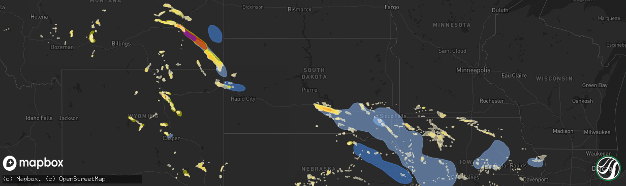
Hail
Wind
3,127
Estimated number of impacted properties by a 1.00" hail or larger483
Estimated number of impacted properties by a 1.75" hail or larger244
Estimated number of impacted properties by a 2.50" hail or largerStorm reports in South Dakota
South Dakota
| Date | Description |
|---|---|
| 07/29/20256:58 PM CDT | Reported via mobile mesonet on x. |
| 07/29/20256:52 PM CDT | Mesonet station 304 sd rwis corsica. |
| 07/29/20256:46 PM CDT | Asos station kmhe mitchell municipal airport. |
| 07/29/20256:23 PM CDT | Mesonet station 214 sd rwis plankinton. |
| 07/29/20256:18 PM CDT | Mesonet station 214 sd rwis plankinton. |
| 07/29/20256:08 PM CDT | Strong winds. Large healthy tree branch down... Estimated 8-9 inches in diameter. Time estimated via radar. |
| 07/29/20256:08 PM CDT | St |
| 07/29/20255:46 PM CDT | Public mesonet wind observation. |
| 07/29/20255:42 PM CDT | Mesonet station 154 sd rwis platte-winner bridge. |
| 07/29/20255:10 PM CDT | Several trees blown over. Very strong winds tore off part of roof of house. |
| 07/29/20255:10 PM CDT | Se |
| 07/29/20255:10 PM CDT | A local report indicates 72 MPH wind near 2 W Oacoma |
| 07/29/20255:05 PM CDT | Wind driven hail stripped siding. 2 barn doors blown off. Cattle blown through fence and out on road. |
| 07/29/20254:51 PM CDT | Member of the public reports hail for about 20 minutes... With the largest being quarter sized. Time estimated by radar. |
| 07/29/20254:45 PM CDT | Reported that winds caused trees to be tipped over and blown into the house. |
| 07/29/20254:45 PM CDT | A local report indicates 65 MPH wind near 2 W Hamill |
| 07/29/20254:36 PM CDT | Member of the public reported trees down in the area and an outbuilding moved. Estimated 80 miles per hour. Time estimated by radar. |
| 07/29/20254:30 PM CDT | Mesonet station kbms2 kennebec 6sse |
| 07/28/202511:10 PM CDT | A local report indicates 1.25 inch wind near 2 SE Dwtn Spearfish |
| 07/28/202511:06 PM CDT | A local report indicates 60 MPH wind near Dwtn Spearfish |
| 07/28/20259:35 PM CDT | Mesonet station 53 sd rwis north sioux city. |
| 07/28/20259:33 PM CDT | Personal weather station. |
| 07/28/20259:05 PM CDT | Mesonet station 16 sd rwis beresfor |
| 07/28/20259:05 PM CDT | Mesonet station 16 sd rwis beresford. |
| 07/28/20258:57 PM CDT | Personal weather station. |
| 07/28/20258:57 PM CDT | Personal weather station. |
| 07/28/20258:55 PM CDT | Mesonet station 197 sd rwis gayville. |
| 07/28/20258:54 PM CDT | Personal weather station. |
| 07/28/20258:52 PM CDT | Awos station kvmr vermillion. |
| 07/28/20258:51 PM CDT | Mesonet station 16 sd rwis beresford. |
| 07/28/20258:51 PM CDT | Mesonet station bfms2 beresford 7 wsw |
| 07/28/20258:48 PM CDT | Mesonet station 320 sd rwis irene. |
| 07/28/20258:33 PM CDT | Personal weather station. |
| 07/28/20258:30 PM CDT | Mesonet station 310 sd rwis parker. |
| 07/28/20258:06 PM CDT | First severe gust at 806 pm... Peak of 69 mph at 816 pm. Hurley sdsu mesonet site. |
| 07/28/20258:05 PM CDT | Personal weather station. |
| 07/28/20258:00 PM CDT | Personal weather station. |
| 07/28/20257:50 PM CDT | Mesonet station 322 sd rwis stanley corner. |
| 07/28/20257:50 PM CDT | Mesonet statio |
| 07/28/20257:49 PM CDT | Personal weather station. |
| 07/28/20257:45 PM CDT | Mesonet station 163 sd rwis freeman. |
| 07/28/20257:45 PM CDT | Personal weather station. |
| 07/28/20257:35 PM CDT | A local report indicates 75 MPH wind near Bridgewater |
| 07/28/20257:35 PM CDT | Scattered tree damage throughout the city of bridgewater. |
| 07/28/20257:32 PM CDT | Personal weather system. |
| 07/28/20257:20 PM CDT | Mesonet station 26 sd rwis tripp. |
| 07/28/20257:15 PM CDT | Mesonet station 213 sd rwis alexandria. |
| 07/28/20257:14 PM CDT | Mesonet station 26 sd rwis tripp. |
| 07/28/20257:01 PM CDT | Personal weather station. |
All States Impacted by Hail Map on July 29, 2025
Cities Impacted by Hail Map on July 29, 2025
- Waterville, MN
- Waseca, MN
- Janesville, MN
- Morristown, MN
- Medford, MN
- Warsaw, MN
- Faribault, MN
- Round Lake, MN
- Bigelow, MN
- Laurens, IA
- Worthington, MN
- Inwood, IA
- Doon, IA
- Pocahontas, IA
- Rock Valley, IA
- Canton, SD
- Alvord, IA
- Fairview, SD
- Hull, IA
- George, IA
- Palmer, IA
- Spirit Lake, IA
- Lake Park, IA
- Manson, IA
- Clare, IA
- Boyden, IA
- Milford, IA
- Okoboji, IA
- Arnolds Park, IA
- Sheldon, IA
- Orange City, IA
- Sanborn, IA
- Terril, IA
- Hospers, IA
- Dickens, IA
- Granville, IA
- Paullina, IA
- Peterson, IA
- Royal, IA
- Primghar, IA
- Spencer, IA
- Graettinger, IA
- Ruthven, IA
- Sutherland, IA
- Emmetsburg, IA
- Hartley, IA
- Sioux Rapids, IA
- Greenville, IA
- Webb, IA
- Ayrshire, IA
- Gillett Grove, IA
- Linn Grove, IA
- Curlew, IA
- Marathon, IA
- Havelock, IA
- Ottosen, IA
- West Bend, IA
- Mallard, IA
- Rolfe, IA
- Albert City, IA
- Bode, IA
- Plover, IA
- Hardy, IA
- Livermore, IA
- Pomeroy, IA
- Humboldt, IA
- Dakota City, IA
- Blenheim, SC
- Galivants Ferry, SC
- Cylinder, IA
- Niceville, FL
- Latta, SC
- Hudson, SD
- Harris, IA
- Adel, GA
- Sioux Center, IA
- Archer, IA
- Hahira, GA
- Thomasville, GA
- Whittemore, IA
- Hardeeville, SC
- Bluffton, SC
- Cairo, GA
- Okatie, SC
- Boston, GA
- Fitzgerald, GA
- Tallahassee, FL
- Delhi, LA
- Panama City Beach, FL
- Bastrop, LA
- Crestview, FL
- Rayville, LA
- Green Pond, SC
- Forest Grove, MT
- Baskin, LA
- Holly, CO
- Ash, NC
- Wagon Mound, NM
- Bethune, CO
- Granada, CO
- Supply, NC
- Forsyth, MT
- Spartanburg, SC
- Glendale, SC
- Plant City, FL
- Dover, FL
- Valrico, FL
- Colorado Springs, CO
- Riceboro, GA
- Monroe, LA
- Kim, CO
- Springer, NM
- White Springs, FL
- Stratton, CO
- Cohagen, MT
- Kentwood, LA
- Marianna, FL
- West Monroe, LA
- Wray, CO
- Vernon, CO
- Hugo, CO
- Parks, NE
- Luverne, AL
- Perry, GA
- Amite, LA
- Presho, SD
- Jasper, FL
- Lake City, FL
- Oviedo, FL
- Townsend, GA
- Rosebud, MT
- Lyons, GA
- Carlisle, SC
- Lithia, FL
- Slocomb, AL
- Kennebec, SD
- Kathleen, GA
- Reliance, SD
- Ramah, CO
- Rush, CO
- Parrish, FL
- Bonaire, GA
- Boone, CO
- Haigler, NE
- Hawkinsville, GA
- Karval, CO
- Penrose, CO
- Warner Robins, GA
- Ideal, SD
- Hamill, SD
- Yoder, CO
- Calhan, CO
- Poplarville, MS
- Carriere, MS
- Silver Creek, MS
- Whatley, AL
- Arcadia, MO
- Annapolis, MO
- Hampton, AR
- Gregory, SD
- Mandaree, ND
- New Town, ND
- Oacoma, SD
- Chamberlain, SD
- Malvern, AR
- Wallace, KS
- Pueblo, CO
- Elba, AL
- Lamar, CO
- Burlington, CO
- Des Arc, MO
- Ordway, CO
- Frisco City, AL
- Roseglen, ND
- Miles City, MT
- Volborg, MT
- Jack, AL
- Herndon, KS
- Colorado City, CO
- Winner, SD
- Sharon Springs, KS
- Lloyd, MT
- Louisville, GA
- Angela, MT
- Kinsey, MT
- Patterson, MO
- Elloree, SC
- Oberlin, KS
- Berry, AL
- Santee, SC
- Culbertson, NE
- New Brockton, AL
- Killdeer, ND
- Pukwana, SD
- Atwood, KS
- Bonne Terre, MO
- Edson, KS
- Shawmut, MT
- Enders, NE
- Wauneta, NE
- North Platte, NE
- Opp, AL
- Winona, KS
- Monticello, MS
- Oak Vale, MS
- Winifred, MT
- Wilsall, MT
- Big Timber, MT
- Kimball, SD
- Platte, SD
- Burke, SD
- Thedford, NE
- McCook, NE
- Danbury, NE
- Stapleton, NE
- Hayes Center, NE
- Bonesteel, SD
- Fairfax, SD
- White Lake, SD
- Dickens, NE
- Wallace, NE
- Canova, SD
- Ponchatoula, LA
- Cameron, SC
- Thermopolis, WY
- Shoshoni, WY
- Buffalo, WY
- Sierraville, CA
- Loyalton, CA
- Pevely, MO
- Ismay, MT
- House Springs, MO
- Van Buren, MO
- Ellington, MO
- Aiken, SC
- Holyoke, CO
- Melville, MT
- Festus, MO
- Altoona, FL
- Champion, NE
- Reed Point, MT
- Chinook, MT
- Stockville, NE
- Fredericktown, MO
- Eureka, MO
- Likely, CA
- Syracuse, KS
- Benkelman, NE
- McDonald, KS
- Bird City, KS
- Max, NE
- Bennett, CO
- Casper, WY
- Arlington, CO
- Brewster, KS
- Cartwright, ND
- Hazen, ND
- Morris, GA
- Cuthbert, GA
- Oneill, NE
- Plankinton, SD
- New Holland, SD
- Mitchell, SD
- Mount Vernon, SD
- Corsica, SD
- Letcher, SD
- Harrison, SD
- Geddes, SD
- Stickney, SD
- Armour, SD
- Fulton, SD
- Ethan, SD
- Woonsocket, SD
- Dimock, SD
- Lake Andes, SD
- Parkston, SD
- Wagner, SD
- Delmont, SD
- Tripp, SD
- Alexandria, SD
- Kaycee, WY
- Fayette, AL
- Winfred, SD
- Elsie, NE
- La Place, LA
- Fremont, MO
- Taylor, NE
- Sargent, NE
- Powderville, MT
- Biddle, MT
- Windsor, SC
- Roy, MT
- Strasburg, CO
- Chatham, MS
- Hollandale, MS
- Greenville, MS
- Glen Allan, MS
- Haswell, CO
- Arnold, NE
- Loranger, LA
- Andalusia, AL
- Williston, SC
- Spencer, SD
- Emery, SD
- Bridgewater, SD
- Salem, SD
- Avon, SD
- Olivet, SD
- Tyndall, SD
- Kaylor, SD
- Freeman, SD
- Canistota, SD
- Scotland, SD
- Lynch, NE
- Lysite, WY
- Stratton, NE
- Butte, NE
- Montrose, SD
- Marion, SD
- Menno, SD
- Utica, SD
- Viborg, SD
- Yankton, SD
- Hurley, SD
- Fordyce, NE
- Saint Helena, NE
- Irene, SD
- Humboldt, SD
- Monroe, SD
- Crofton, NE
- Mission Hill, SD
- Parker, SD
- Lesterville, SD
- Tabor, SD
- Volin, SD
- Gayville, SD
- Wynot, NE
- Maxwell, NE
- Artesian, SD
- Fedora, SD
- Sugar City, CO
- Naper, NE
- Madison, SD
- Cheyenne, WY
- Boyes, MT
- Ekalaka, MT
- Hammond, MT
- Busby, MT
- Lame Deer, MT
- Fairfield, ND
- Medora, ND
- Dawson, GA
- Wentworth, SD
- Fulda, MN
- Poplar Bluff, MO
- Reading, MN
- Clearmont, WY
- Decker, MT
- Leary, GA
- Worthing, SD
- Chancellor, SD
- Lennox, SD
- Hartford, SD
- Wakonda, SD
- Tea, SD
- Beresford, SD
- Vermillion, SD
- Davis, SD
- Harrisburg, SD
- Centerville, SD
- Sioux Falls, SD
- Gillette, WY
- Pritchett, CO
- Buffalo Center, IA
- Montverde, FL
- Anselmo, NE
- Callaway, NE
- Okabena, MN
- Colton, SD
- Heron Lake, MN
- Brewster, MN
- Curtis, NE
- Rushmore, MN
- Palisade, NE
- Page, NE
- Verdigre, NE
- Orchard, NE
- Winnetoon, NE
- Royal, NE
- Creighton, NE
- Brunswick, NE
- Plainview, NE
- Neligh, NE
- Ewing, NE
- Clearwater, NE
- Osmond, NE
- Wausa, NE
- Mclean, NE
- Randolph, NE
- Pierce, NE
- Meadow Grove, NE
- Tilden, NE
- Norfolk, NE
- Battle Creek, NE
- Renner, SD
- Baltic, SD
- Crooks, SD
- Lyons, SD
- Garretson, SD
- Larchwood, IA
- Brandon, SD
- Hills, MN
- Valley Springs, SD
- Elk Point, SD
- Alcester, SD
- Burbank, SD
- Elm Creek, NE
- Odessa, NE
- Riverdale, NE
- Kearney, NE
- Axtell, NE
- Funk, NE
- Alzada, MT
- Belfield, ND
- Arapahoe, CO
- Pickstown, SD
- Ceylon, MN
- Glidden, IA
- Carroll, IA
- Madrid, NE
- Levant, KS
- Fairmont, MN
- Welcome, MN
- Parkman, WY
- Scranton, IA
- Brady, NE
- Jefferson, IA
- Rake, IA
- Gothenburg, NE
- Greenwood Springs, MS
- Marion, AL
- Broadus, MT
- Lake Mills, IA
- Leland, IA
- Waterbury, NE
- Jackson, NE
- Allen, NE
- Jefferson, SD
- Akron, IA
- Ponca, NE
- Westfield, IA
- Newcastle, NE
- Chatsworth, IA
- Hawarden, IA
- North Sioux City, SD
- Dakota City, NE
- Sioux City, IA
- South Sioux City, NE
- Merrill, IA
- Rock Rapids, IA
- Le Mars, IA
- Ireton, IA
- Lester, IA
- Dixon, NE
- Maskell, NE
- Winside, NE
- Carroll, NE
- Hoskins, NE
- Stanton, NE
- Gibbon, NE
- Mason City, NE
- Litchfield, NE
- Ansley, NE
- Arcadia, NE
- Loup City, NE
- North Loup, NE
- Ravenna, NE
- Scotia, NE
- Boelus, NE
- Saint Paul, NE
- Ord, NE
- Rockville, NE
- Farwell, NE
- Dannebrog, NE
- Elba, NE
- Ashton, NE
- Wessington Springs, SD
- Greeley, NE
- Wolbach, NE
- Howard, SD
- Beach, ND
- Lakefield, MN
- Cope, CO
- Spencer, NE
- Storm Lake, IA
- Dunnell, MN
- Cozad, NE
- Wilmont, MN
- Chester, SD
- Coleman, GA
- Burwell, NE
- Dell Rapids, SD
- Joice, IA
- Jackson, MN
- Caledonia, MS
- Gattman, MS
- Amory, MS
- Plevna, MT
- Baker, MT
- Willard, MT
- Merna, NE
- Sherburn, MN
- Thompson, IA
- Hulett, WY
- Hornick, IA
- Shellman, GA
- Termo, CA
- Sheridan, WY
- Rockwell City, IA
- Jolley, IA
- Kingsley, IA
- Dolliver, IA
- Fonda, IA
- Yale, IA
- Scarville, IA
- Stuart, NE
- Goodland, KS
- Brent, AL
- Bagley, IA
- Bronson, IA
- Reno, NV
- Roggen, CO
- Ogallala, NE
- Hilger, MT
- Broken Bow, NE
- Armstrong, IA
- Sundance, WY
- Douglas, WY
- El Paso, TX
- Northwood, IA
- Salix, IA
- Sergeant Bluff, IA
- Rock River, WY
- Fertile, IA
- Hanlontown, IA
- Forest City, IA
- Vona, CO
- Mason City, IA
- Clear Lake, IA
- Manly, IA
- Kensett, IA
- Otter, MT
- Panora, IA
- Smithland, IA
- Oto, IA
- Cleghorn, IA
- Brunsville, IA
- Remsen, IA
- Oyens, IA
- Marcus, IA
- Alton, IA
- Maurice, IA
- Hinton, IA
- Overton, NE
- Hubbard, NE
- Decatur, NE
- Whiting, IA
- Climbing Hill, IA
- Washta, IA
- Homer, NE
- Onawa, IA
- Anthon, IA
- Moville, IA
- Sloan, IA
- Lawton, IA
- Pierson, IA
- Macy, NE
- Correctionville, IA
- Walthill, NE
- Winnebago, NE
- Meriden, IA
- Larrabee, IA
- Castana, IA
- Cushing, IA
- Mapleton, IA
- Rodney, IA
- Ida Grove, IA
- Danbury, IA
- Calumet, IA
- Holstein, IA
- Battle Creek, IA
- Quimby, IA
- Cherokee, IA
- Aurelia, IA
- Galva, IA
- Pender, NE
- Wayne, NE
- Lyons, NE
- Oakland, NE
- Madison, NE
- West Point, NE
- Beemer, NE
- Wisner, NE
- Bancroft, NE
- Pilger, NE
- Clarkson, NE
- Craig, NE
- Howells, NE
- Snyder, NE
- Scribner, NE
- Dodge, NE
- North Bend, NE
- Hooper, NE
- Leigh, NE
- Bosler, WY
- Belle Fourche, SD
- Charles City, IA
- Rockford, IA
- Plymouth, IA
- Weirsdale, FL
- Bartlett, NE
- Alta, IA
- Wakefield, NE
- Macdoel, CA
- Ericson, NE
- Eufaula, AL
- Grafton, IA
- Birney, MT
- Banner, WY
- Wheatland, WY
- Emerson, NE
- Akron, CO
- Spalding, NE
- Cedar Rapids, NE
- Trent, SD
- Spearfish, SD
- Whitewood, SD
- Saint Onge, SD
- Lead, SD
- Shell Knob, MO
- Genoa, NE
- Fullerton, NE
- Klamath Falls, OR
- Primrose, NE
- Fort Dodge, IA
- Belgrade, NE
- Charter Oak, IA
- Schleswig, IA
- Denison, IA
- Fosters, AL
- Ralph, AL
- Knoxville, AL
- Tekamah, NE
- Mondamin, IA
- Herman, NE
- Uehling, NE
- Winslow, NE
- Modale, IA
- Missouri Valley, IA
- Nickerson, NE
- Arlington, NE
- Blair, NE
- Kennard, NE
- Fort Calhoun, NE
- Fremont, NE
- Omaha, NE
- Crescent, IA
- Elkhorn, NE
- Bennington, NE
- Ames, NE
- Washington, NE
- Valley, NE
- Arion, IA
- Defiance, IA
- Ute, IA
- Dow City, IA
- Pisgah, IA
- Little Sioux, IA
- Moorhead, IA
- Earling, IA
- Ricketts, IA
- Blencoe, IA
- Soldier, IA
- Dunlap, IA
- Woodbine, IA
- Arthur, IA
- Kiron, IA
- Deloit, IA
- Vail, IA
- Manilla, IA
- Odebolt, IA
- Sturgis, SD
- Deadwood, SD
- Stuart, IA
- Adel, IA
- Dallas Center, IA
- Amidon, ND
- Titonka, IA
- Burt, IA
- Johnston, IA
- Urbandale, IA
- Midway, AL
- Fenton, IA
- Nora Springs, IA
- Rock Falls, IA
- Wyola, MT
- Elkin, NC
- West Des Moines, IA
- Windsor Heights, IA
- Grimes, IA
- Waukee, IA
- Clive, IA
- Polk City, IA
- Morgan, GA
- Colby, KS
- Petersburg, NE
- Rudd, IA
- Marble Rock, IA
- Chugwater, WY
- Bozeman, MT
- Lagrange, WY
- Dayton, WY
- Albion, NE
- Saint Edward, NE
- Des Moines, IA
- Martell, NE
- Roca, NE
- Crete, NE
- Malcolm, NE
- Denton, NE
- Davey, NE
- Walton, NE
- Bennet, NE
- Waverly, NE
- Raymond, NE
- Lincoln, NE
- Elmwood, NE
- Ceresco, NE
- Ashland, NE
- Murdock, NE
- Springfield, NE
- Alvo, NE
- Valparaiso, NE
- Greenwood, NE
- Palmyra, NE
- Eagle, NE
- Gretna, NE
- Otoe, NE
- Unadilla, NE
- Louisville, NE
- Weeping Water, NE
- Avoca, NE
- Syracuse, NE
- South Bend, NE
- Pleasant Dale, NE
- Papillion, NE
- La Vista, NE
- Manley, NE
- Cedar Creek, NE
- Dunbar, NE
- Nehawka, NE
- Plattsmouth, NE
- Union, NE
- Nebraska City, NE
- Murray, NE
- Hanna, WY
- Belgrade, MT
- Merino, CO
- Nashua, IA
- Webber, KS
- Logan, IA
- Torrington, WY
- Walnut Cove, NC
- Townsend, MT
- Three Forks, MT
- Norwalk, IA
- Underwood, IA
- Council Bluffs, IA
- Ranchester, WY
- Canon, GA
- Carnesville, GA
- Royston, GA
- Carlisle, IA
- State Center, IA
- Marshalltown, IA
- Danielsville, GA
- Rhodes, IA
- Laurel, IA
- Liscomb, IA
- Melbourne, IA
- Albion, IA
- Haverhill, IA
- Colo, IA
- Clemons, IA
- Conrad, IA
- Union, IA
- Saint Anthony, IA
- Le Grand, IA
- Garwin, IA
- Gilman, IA
- Newton, IA
- Ferguson, IA
- Beaman, IA
- Reinbeck, IA
- Holland, IA
- Grundy Center, IA
- Dike, IA
- Gladbrook, IA
- Zearing, IA
- Traer, IA
- Morrison, IA
- Montour, IA
- Tama, IA
- Chelsea, IA
- Toledo, IA
- Lincoln, IA
- Clutier, IA
- Bellevue, NE
- Fort Meade, SD
- Harlowton, MT
- Griswold, IA
- Fishtail, MT
- Malvern, IA
- Ionia, IA
- Franklin, LA
- Ralston, IA
- Whitehall, MT
- Cardwell, MT
- Macedonia, IA
- Kellogg, IA
- Hancock, IA
- Thurman, IA
- Minden, IA
- Treynor, IA
- McClelland, IA
- Tabor, IA
- Pacific Junction, IA
- Yoder, WY
- Henderson, IA
- Oakland, IA
- Glenwood, IA
- Hastings, IA
- Silver City, IA
- Lodge Grass, MT
- Atlantic, IA
- Belle Plaine, IA
- Hull, GA
- Athens, GA
- Exira, IA
- Brayton, IA
- Avoca, IA
- Emerson, IA
- Carson, IA
- Red Oak, IA
- Greene, IA
- Casey, IA
- Adair, IA
- Philipsburg, MT
- Fort Atkinson, IA
- Waucoma, IA
- Elberon, IA
- Toston, MT
- Cedar Falls, IA
- Hudson, IA
- La Porte City, IA
- Waterloo, IA
- Denver, IA
- Dysart, IA
- Buckingham, IA
- Vining, IA
- Tripoli, IA
- Janesville, IA
- Waverly, IA
- Readlyn, IA
- Newhall, IA
- Van Horne, IA
- Keystone, IA
- Rowley, IA
- Garrison, IA
- Independence, IA
- Vinton, IA
- Raymond, IA
- Brandon, IA
- Fairbank, IA
- Shellsburg, IA
- Walker, IA
- Center Point, IA
- Dunkerton, IA
- Mount Auburn, IA
- Jesup, IA
- Blairstown, IA
- Evansdale, IA
- Luzerne, IA
- Dewar, IA
- Urbana, IA
- Gilbertville, IA
- Atkins, IA
- Palo, IA
- Westside, IA
- Wall Lake, IA
- Arcadia, IA
- Breda, IA
- Auburn, IA
- Lake City, IA
- Harlan, IA
- Manning, IA
- Templeton, IA
- Aspinwall, IA
- Audubon, IA
- Irwin, IA
- Kirkman, IA
- Persia, IA
- Lidderdale, IA
- Panama, IA
- Westphalia, IA
- Halbur, IA
- Neola, IA
- Portsmouth, IA
- Shelby, IA
- Churdan, IA
- Gray, IA
- Kimballton, IA
- Elk Horn, IA
- Walnut, IA
- Dedham, IA
- Coon Rapids, IA
- Grand Junction, IA
- Bayard, IA
- Rippey, IA
- Ogden, IA
- Hamlin, IA
- Jamaica, IA
- Guthrie Center, IA
- Dana, IA
- Boone, IA
- Marne, IA
- Beaver, IA
- Dawson, IA
- Perry, IA
- Lewis, IA
- Anita, IA
- Wiota, IA
- Cumberland, IA
- Elliott, IA
- Menlo, IA
- Linden, IA
- Villisca, IA
- Massena, IA
- Corning, IA
- Bridgewater, IA
- Grant, IA
- Fontanelle, IA
- Minburn, IA
- Dexter, IA
- Greenfield, IA
- Woodward, IA
- Orient, IA
- Prescott, IA
- Redfield, IA
- Creston, IA
- Mankato, KS
- Marengo, IA
- Hartwick, IA
- Humboldt, NE
- Table Rock, NE
- Sumner, IA
- Lawler, IA
- Auburn, NE
- Lexington, NE
- Eddyville, NE
- Coin, IA
- Shenandoah, IA
- Northboro, IA
- Oelwein, IA
- Hazleton, IA
- Oran, IA
- Aurora, IA
- Coggon, IA
- Quasqueton, IA
- Winthrop, IA
- Bouton, IA
- Earlham, IA
- Macksburg, IA
- Winterset, IA
- De Soto, IA
- Van Meter, IA
- Grover, CO
- Clarinda, IA
- Oconto, NE
- Blanchard, IA
- Dyersville, IA
- Elmo, MO
- Clearmont, MO
- Solon, IA
- Shambaugh, IA
- New Market, IA
- Miller, NE
- Burlington Junction, MO
- Bedford, IA
- Braddyville, IA
- Macon, MS
- Hopkins, MO
- Graham, MO
- Elyria, NE
- Farley, IA
- Brooksville, MS
- Hazard, NE
- Pickering, MO
- Maryville, MO
- Story, WY
- Seymour, TX
- Moorcroft, WY
- Mechanicsville, IA
- Skidmore, MO
- Nye, MT
- Conception Junction, MO
- Ravenwood, MO
- Silver Creek, NE
- Tipton, IA
- Hawkeye, IA
- Maquoketa, IA
- West Liberty, IA
- Atalissa, IA
- Nichols, IA
- Parnell, MO
- Bellevue, IA
- Lamoni, IA
- Decatur, IA
- Savanna, IL
- Andrew, IA
- Preston, IA
- Spragueville, IA
- Muscatine, IA
- Davis City, IA
- Alva, WY
- Shelby, NE
- Osceola, NE
- Farragut, IA
- Absarokee, MT
- Hanover, IL
- Marion, IA
- Alburnett, IA
- Toddville, IA
- Elizabeth, IL
- Miles, IA
- Brooklyn, IA
- Arnold, CA
- Lovilia, IA
- Knoxville, IA
- Hamilton, IA
- Grinnell, IA
- Lisbon, IA
- Ely, IA
- Beulah, WY
- West Branch, IA
- Sabula, IA
- Aladdin, WY
- Malcom, IA
- Yutan, NE
- Lyman, NE
- Hawk Springs, WY
- Morrill, NE
- Stockton, IL
- Waterloo, NE
- Pine Bluffs, WY
- Leighton, IA
- Mount Carroll, IL
- Chadwick, IL
- New Sharon, IA
- Long Barn, CA
- Lanark, IL
- Ottumwa, IA
- Deep River, IA
- What Cheer, IA
- Delta, IA
- Rose Hill, IA
- Oskaloosa, IA
- Milledgeville, IL
- Hedrick, IA
- Sigourney, IA
- Maysville, MO
- McFall, MO
- Agency, IA
- Zwingle, IA
- Monmouth, IA
- Wyoming, IA
- Baldwin, IA
- La Motte, IA
- De Witt, IA
- Delmar, IA
- Charlotte, IA
- Lost Nation, IA
- Oxford Junction, IA
- Goose Lake, IA
- Bryant, IA
- Clinton, IA
- Ollie, IA
- Hayesville, IA
- Ludell, KS
- Packwood, IA
- Manderson, WY
- Libertyville, IA
- Eldon, IA
- Birmingham, IA
- Fairfield, IA
- Bonaparte, IA
- Keosauqua, IA


