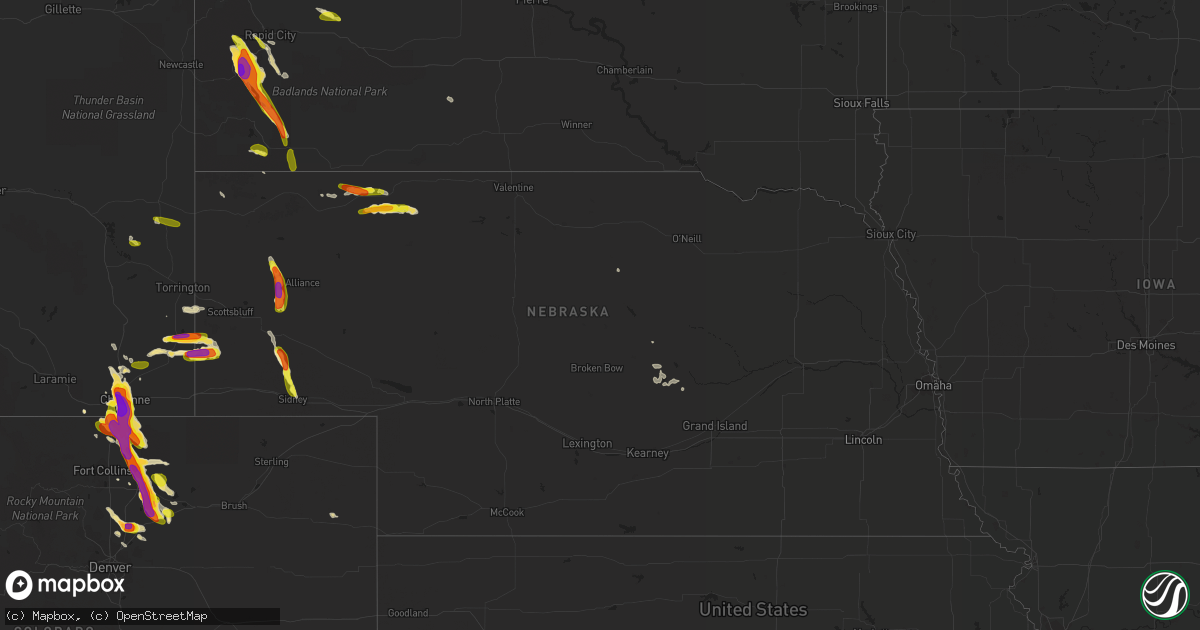
Hail Map in Nebraska on July 29, 2016
Get this storm
July 29 map
$229
one time, instant access
Download today. No call, no setup
Keep the $229
Bought the map and want the full workflow? Apply the entire $229 to a subscription within 7 days. None of it is wasted.
Every map, not just this one
This buys you this map. Subscription and you get every map we run, in the markets you choose from a few cities to whole states to nationwide. Plus real-time alerts the moment a storm fires.
Contact data
Name, contact info, occupancy, even credit band for addresses in the footprint. You go from where it hit to who to call.
Become the source they trust
Unlimited branding weather history reports on demand. You already have the documented answer ready for the property owner, and you are the one who showed up with it.
Property data and RoofTrace estimates
Pull up any address you have got, its value and the exact code rules for that jurisdiction, straight from One Click Code. Then RoofTrace estimates the squares, pitch, and roof value, priced the way you price.
Storm reports in Nebraska
Nebraska
| Date | Description |
|---|---|
| 07/29/20166:46 PM CDT | A local report indicates 1.25 inch wind near 7 WSW DALTON |
| 07/29/20166:30 PM CDT | Pea to ping pong size hail covered ground. |
| 07/29/20166:26 PM CDT | A local report indicates 1.50 inch wind near 15 ESE GORDON |
| 07/29/20166:13 PM CDT | A local report indicates 1.50 inch wind near 19 SW MERRIMAN |
| 07/29/20166:00 PM CDT | A local report indicates 60 MPH wind near 4 W GORDON |
| 07/29/20165:42 PM CDT | Power pole snapped. |
| 07/28/20167:35 PM CDT | A local report indicates 1.25 inch wind near 2 N SIDNEY |
All States Impacted by Hail Map on July 29, 2016
Cities Impacted by Hail Map on July 29, 2016
- Windsor, CO
- Cheyenne, WY
- Fe Warren Afb, WY
- Brighton, CO
- Fort Lupton, CO
- Commerce City, CO
- Henderson, CO
- Tucson, AZ
- Sedan, NM
- Hartville, WY
- Glendo, WY
- Viola, AR
- Salem, AR
- La Porte, IN
- Folsom, NM
- Mena, AR
- Hudson, CO
- Hermosa, SD
- Keystone, SD
- Hill City, SD
- Custer, SD
- Boise City, OK
- Lagrange, WY
- Harrisburg, NE
- Pine Bluffs, WY
- Albin, WY
- Rapid City, SD
- Mayer, AZ
- Loup City, NE
- San Ysidro, NM
- Yoder, WY
- Ault, CO
- Eaton, CO
- Pierce, CO
- Greeley, CO
- Gill, CO
- Nunn, CO
- Carr, CO
- Keenesburg, CO
- Roggen, CO
- Kersey, CO
- La Salle, CO
- Wellington, CO
- Alliance, NE
- Longmont, CO
- Heavener, OK
- Ord, NE
- Arcadia, NE
- Dumas, TX
- Oelrichs, SD
- Burwell, NE
- Bassett, NE
- Oral, SD
- Buffalo Gap, SD
- Hemingford, NE
- Briggsdale, CO
- Chadron, NE
- Rushville, NE
- Gordon, NE
- Jemez Pueblo, NM
- Lusk, WY
- Jay Em, WY
- Dalton, NE
- Bayard, NE
- Bridgeport, NE
- Torrington, WY
- Lyman, NE
- Buckeye, AZ
- Meriden, WY
- Platteville, CO
- Mead, CO
- Mill Creek, IN
- Rolling Prairie, IN
- Clayton, NM
- Sells, AZ
- Kenton, OK
- Lucerne, CO
- Granite Canon, WY
- Branson, CO
- Hawk Springs, WY
- Merriman, NE
- Owanka, SD
- New Underwood, SD
- Fairburn, SD
- Gurley, NE
- Sidney, NE
- Rimrock, AZ
- Wellington, TX
- Hay Springs, NE
- Vail, AZ
- Morrill, NE
- Long Valley, SD
- Angora, NE
- Payson, AZ
- Eckley, CO
- Wasta, SD
- Farwell, NE
- Dalhart, TX
- Edgemont, SD
- Harrison, NE
- Ashton, NE
- Elba, NE
- Pine Ridge, SD
- Florissant, CO


