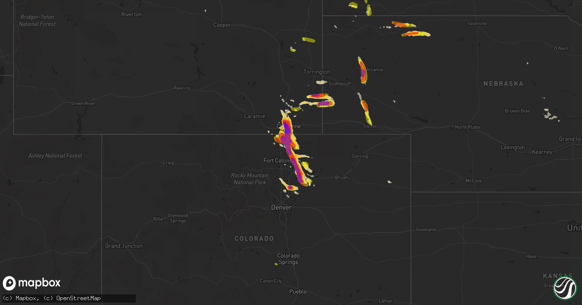
Hail Map on July 29, 2016
Get this storm
July 29 map
$229
one time, instant access
Download today. No call, no setup
Keep the $229
Bought the map and want the full workflow? Apply the entire $229 to a subscription within 7 days. None of it is wasted.
Every map, not just this one
This buys you this map. Subscription and you get every map we run, in the markets you choose from a few cities to whole states to nationwide. Plus real-time alerts the moment a storm fires.
Contact data
Name, contact info, occupancy, even credit band for addresses in the footprint. You go from where it hit to who to call.
Become the source they trust
Unlimited branding weather history reports on demand. You already have the documented answer ready for the property owner, and you are the one who showed up with it.
Property data and RoofTrace estimates
Pull up any address you have got, its value and the exact code rules for that jurisdiction, straight from One Click Code. Then RoofTrace estimates the squares, pitch, and roof value, priced the way you price.
States Impacted by Hail Map on July 29, 2016
Storm reports
South Dakota
| Date | Description |
|---|---|
| 07/29/20166:07 PM CDT | A local report indicates 1.00 inch wind near 4 SSW ELM SPRINGS |
| 07/29/20166:00 PM CDT | A local report indicates 1.00 inch wind near 3 ENE ORAL |
| 07/29/20166:00 PM CDT | A local report indicates 60 MPH wind near 3 ENE ORAL |
| 07/29/20165:10 PM CDT | A local report indicates 1.00 inch wind near 6 ESE DOWNTOWN CUSTER |
| 07/29/20165:09 PM CDT | A local report indicates 1.50 inch wind near 10 E DOWNTOWN CUSTER |
| 07/29/20164:50 PM CDT | Relayed through mt coolidge comms |
| 07/29/20164:45 PM CDT | A local report indicates 1.75 inch wind near 5 S HILL CITY |
| 07/29/20164:40 PM CDT | A local report indicates 1.00 inch wind near MOUNT RUSHMORE |
| 07/29/20164:35 PM CDT | A local report indicates 1.00 inch wind near 1 NE KEYSTONE |
| 07/29/20162:50 PM CDT | A local report indicates 1.00 inch wind near 2 NW BUFFALO GAP |
| 07/29/20162:24 PM CDT | Mostly dime size |
Arizona
| Date | Description |
|---|---|
| 07/29/20166:53 PM CDT | Peak gust reported on the 0453 pm observation. |
| 07/29/20166:37 PM CDT | Estimated 60 to 70 mph winds. |
| 07/29/20166:36 PM CDT | A local report indicates 59 MPH wind near 4 ENE SAFFORD |
| 07/29/20166:34 PM CDT | Estimated 60 to 70 mph winds and pea sized hail. |
| 07/29/20166:14 PM CDT | Estimated 60 to 70 mph winds and pea sized hail. |
| 07/28/201611:43 PM CDT | Gila bend af aux field reported wind gusts of 89 mph. |
| 07/28/201611:03 PM CDT | 3 trees blown down... 6 in diameter. |
| 07/28/201611:01 PM CDT | 2 ft diameter tree uprooted. |
| 07/28/201610:55 PM CDT | Awos station 6 wnw buckeye /bxk/. |
| 07/28/201610:50 PM CDT | Overturned horse trailer and downed power lines via buckeye pd photos. Time estimated based on radar. |
| 07/28/201610:40 PM CDT | A few palo verde trees down and curb to curb flooding. Time estimated based on radar. Yuma road and watson rd. |
| 07/28/201610:30 PM CDT | At least 25 moderate sized trees snapped or uprooted. Time estimated from radar. |
| 07/28/201610:25 PM CDT | Numerous trees uprooted and snapped in goodyear per photos on social media. Time estimated from radar. |
| 07/28/201610:15 PM CDT | Mesonet station 4 wsw phoenix /srp32/. |
| 07/28/201610:15 PM CDT | Asos station phoenix sky harbor intl arpt /phx/. |
| 07/28/201610:10 PM CDT | Mesonet station 4 se maricopa /up559/. |
| 07/28/201610:00 PM CDT | Local media reported at power poles down. Pictures on social media confirmed at least one pole knocked down. |
| 07/28/201610:00 PM CDT | A local report indicates 68 MPH wind near 4 E SUN LAKES |
| 07/28/20169:58 PM CDT | Cover for scale blown down on ranch. |
| 07/28/20169:55 PM CDT | Awos station casa grande municipal airport /cgz/. |
| 07/28/20168:43 PM CDT | Mesonet station 2 sse roosevelt /au919/. |
| 07/28/20168:40 PM CDT | Delayed report...large tree down along cdo bike path near magee rd. Time estimated based on radar. |
| 07/28/20168:15 PM CDT | Damage to eeges restaurant at ina and thornydale. Twitter report of 74 mph gust at ina and thornydale. Time estimated. |
| 07/28/20168:10 PM CDT | Large tree down near intersection of ina and mona lisa rd. |
| 07/28/20167:55 PM CDT | Estimated 60 to 70 mph winds. |
| 07/28/20167:53 PM CDT | 74 mph wind gust recorded on cwop site cw6532 |
| 07/28/20167:52 PM CDT | Near spring valley north of cordes junction |
| 07/28/20167:45 PM CDT | Cover for scale blown down on ranch. |
| 07/28/20167:30 PM CDT | Wind gust reported on the 605 pm observation. Time of gusts estimated by radar. |
Wyoming
| Date | Description |
|---|---|
| 07/29/20165:48 PM CDT | A local report indicates 1.75 inch wind near CHEYENNE |
| 07/29/20165:46 PM CDT | A local report indicates 1.50 inch wind near 23 W CHEYENNE |
| 07/29/20165:42 PM CDT | A local report indicates 1.25 inch wind near 23 W CHEYENNE |
| 07/29/20165:30 PM CDT | It estimated to fell between 4 to 430 pm. |
| 07/29/20165:25 PM CDT | A local report indicates 2.75 inch wind near 4 W CHEYENNE |
| 07/29/20165:18 PM CDT | A local report indicates 1.00 inch wind near CHEYENNE |
| 07/29/20165:17 PM CDT | A local report indicates 1.00 inch wind near 1 W CHEYENNE |
| 07/29/20165:15 PM CDT | A local report indicates 1.75 inch wind near 2 N CHEYENNE |
| 07/29/20165:14 PM CDT | A local report indicates 2.00 inch wind near 2 N CHEYENNE |
| 07/29/20164:03 PM CDT | A local report indicates 2.50 inch wind near 3 NW LA GRANGE |
| 07/29/20164:03 PM CDT | A local report indicates 1.75 inch wind near LA GRANGE |
| 07/29/20164:03 PM CDT | A local report indicates 2.00 inch wind near 2 NW LA GRANGE |
| 07/29/20163:50 PM CDT | Along highway 85. |
Colorado
| Date | Description |
|---|---|
| 07/29/20166:35 PM CDT | A local report indicates 1.75 inch wind near 7 SE CARR |
| 07/29/20166:35 PM CDT | A local report indicates 1.50 inch wind near S CARR |
| 07/29/20166:33 PM CDT | A local report indicates 2.00 inch wind near NATURAL FORT REST AREA |
| 07/29/20164:05 PM CDT | . |
| 07/29/20161:23 AM CDT | A local report indicates 1.25 inch wind near ROGGEN |
| 07/28/201611:10 PM CDT | A local report indicates 1.75 inch wind near 1 NW AULT |
| 07/28/20169:55 PM CDT | A local report indicates 2.00 inch wind near 1 NE FORT LUPTON |
| 07/28/20169:45 PM CDT | A local report indicates 1.50 inch wind near 1 SSW FORT LUPTON |
| 07/28/20168:35 PM CDT | A local report indicates 1.50 inch wind near NW PIERCE |
| 07/28/20168:35 PM CDT | A local report indicates 2.50 inch wind near 2 ESE MILTON RESERVOIR |
| 07/28/20168:30 PM CDT | A local report indicates 2.50 inch wind near 1 WSW KERSEY |
| 07/28/20168:26 PM CDT | A local report indicates 1.75 inch wind near 2 NE MILTON RESERVOIR |
| 07/28/20168:25 PM CDT | A local report indicates 1.00 inch wind near 1 E GREELEY |
| 07/28/20168:25 PM CDT | A local report indicates 1.25 inch wind near 4 NE GILL |
| 07/28/20168:20 PM CDT | Large tree limb down on unc greeley. Power lines down in ne greeley. |
| 07/28/20168:17 PM CDT | A local report indicates 1.25 inch wind near 3 SE EATON |
| 07/28/20168:15 PM CDT | Damaged car windows |
| 07/28/20168:15 PM CDT | A local report indicates 2.00 inch wind near 2 ENE GREELEY |
| 07/28/20168:15 PM CDT | A local report indicates 2.00 inch wind near 4 SE LUCERNE |
| 07/28/20168:13 PM CDT | At the greeley airport |
| 07/28/20168:13 PM CDT | At the greeley airport |
| 07/28/20168:05 PM CDT | A local report indicates 1.75 inch wind near 3 N GREELEY |
| 07/28/20168:00 PM CDT | A local report indicates 1.50 inch wind near AULT |
| 07/28/20167:56 PM CDT | A local report indicates 1.75 inch wind near AULT |
| 07/28/20167:55 PM CDT | A local report indicates 1.50 inch wind near EATON |
| 07/28/20167:55 PM CDT | A local report indicates 1.25 inch wind near ENE EATON |
| 07/28/20167:51 PM CDT | Second round of golfball sized tonight |
| 07/28/20167:37 PM CDT | A local report indicates 1.75 inch wind near 4 E PIERCE |
| 07/28/20167:28 PM CDT | A local report indicates 1.00 inch wind near 4 W CARR |
| 07/28/20167:26 PM CDT | A local report indicates 1.75 inch wind near 2 NW NUNN |
Tennessee
| Date | Description |
|---|---|
| 07/29/20165:35 PM CDT | A large tree fell and broke through the roof of a home in the 700 block of honduras rd. |
Illinois
| Date | Description |
|---|---|
| 07/29/20164:44 PM CDT | One large tree blown down on linden road. |
Texas
| Date | Description |
|---|---|
| 07/28/201610:45 PM CDT | Sustained 40 mph. Measured by the west tx mesonet. |
| 07/28/20168:05 PM CDT | A local report indicates 59 MPH wind near DALHART |
| 07/28/20167:00 PM CDT | 4-6 inch diameter tree branches downed by strong wind gusts |
Nebraska
| Date | Description |
|---|---|
| 07/29/20166:46 PM CDT | A local report indicates 1.25 inch wind near 7 WSW DALTON |
| 07/29/20166:30 PM CDT | Pea to ping pong size hail covered ground. |
| 07/29/20166:26 PM CDT | A local report indicates 1.50 inch wind near 15 ESE GORDON |
| 07/29/20166:13 PM CDT | A local report indicates 1.50 inch wind near 19 SW MERRIMAN |
| 07/29/20166:00 PM CDT | A local report indicates 60 MPH wind near 4 W GORDON |
| 07/29/20165:42 PM CDT | Power pole snapped. |
| 07/28/20167:35 PM CDT | A local report indicates 1.25 inch wind near 2 N SIDNEY |
Missouri
| Date | Description |
|---|---|
| 07/29/20162:35 PM CDT | Severe thunderstorm wind gusts downed tree limbs on highway yy. |
| 07/29/20162:30 PM CDT | Limbs down. Phone line wires into two homes down. |
Indiana
| Date | Description |
|---|---|
| 07/29/20162:20 PM CDT | Time estimated from radar. |
| 07/29/20161:20 PM CDT | Time estimated from radar. |
California
| Date | Description |
|---|---|
| 07/29/20166:43 PM CDT | California highway patrol reports a large tree on us 395 on the northwest side of bishop. |
New Mexico
| Date | Description |
|---|---|
| 07/29/20164:11 PM CDT | Kgup asos. |
Arkansas
| Date | Description |
|---|---|
| 07/29/20164:25 PM CDT | Numerous trees and powerlines down along kerr rd north of interstate 40. |
| 07/29/20163:55 PM CDT | A tree was snapped near financial parkway and shackleford. |
| 07/29/20162:55 PM CDT | A local report indicates 1.00 inch wind near SALEM |
| 07/28/20168:10 PM CDT | A few powerlines were knocked down near north 10th street. |
| 07/28/20167:00 PM CDT | Very strong winds also observed at time of report. |
Cities Impacted by Hail Map on July 29, 2016
- Windsor, CO
- Cheyenne, WY
- Fe Warren Afb, WY
- Brighton, CO
- Fort Lupton, CO
- Commerce City, CO
- Henderson, CO
- Tucson, AZ
- Sedan, NM
- Hartville, WY
- Glendo, WY
- Viola, AR
- Salem, AR
- La Porte, IN
- Folsom, NM
- Mena, AR
- Hudson, CO
- Hermosa, SD
- Keystone, SD
- Hill City, SD
- Custer, SD
- Boise City, OK
- Lagrange, WY
- Harrisburg, NE
- Pine Bluffs, WY
- Albin, WY
- Rapid City, SD
- Mayer, AZ
- Loup City, NE
- San Ysidro, NM
- Yoder, WY
- Ault, CO
- Eaton, CO
- Pierce, CO
- Greeley, CO
- Gill, CO
- Nunn, CO
- Carr, CO
- Keenesburg, CO
- Roggen, CO
- Kersey, CO
- La Salle, CO
- Wellington, CO
- Alliance, NE
- Longmont, CO
- Heavener, OK
- Ord, NE
- Arcadia, NE
- Dumas, TX
- Oelrichs, SD
- Burwell, NE
- Bassett, NE
- Oral, SD
- Buffalo Gap, SD
- Hemingford, NE
- Briggsdale, CO
- Chadron, NE
- Rushville, NE
- Gordon, NE
- Jemez Pueblo, NM
- Lusk, WY
- Jay Em, WY
- Dalton, NE
- Bayard, NE
- Bridgeport, NE
- Torrington, WY
- Lyman, NE
- Buckeye, AZ
- Meriden, WY
- Platteville, CO
- Mead, CO
- Mill Creek, IN
- Rolling Prairie, IN
- Clayton, NM
- Sells, AZ
- Kenton, OK
- Lucerne, CO
- Granite Canon, WY
- Branson, CO
- Hawk Springs, WY
- Merriman, NE
- Owanka, SD
- New Underwood, SD
- Fairburn, SD
- Gurley, NE
- Sidney, NE
- Rimrock, AZ
- Wellington, TX
- Hay Springs, NE
- Vail, AZ
- Morrill, NE
- Long Valley, SD
- Angora, NE
- Payson, AZ
- Eckley, CO
- Wasta, SD
- Farwell, NE
- Dalhart, TX
- Edgemont, SD
- Harrison, NE
- Ashton, NE
- Elba, NE
- Pine Ridge, SD
- Florissant, CO