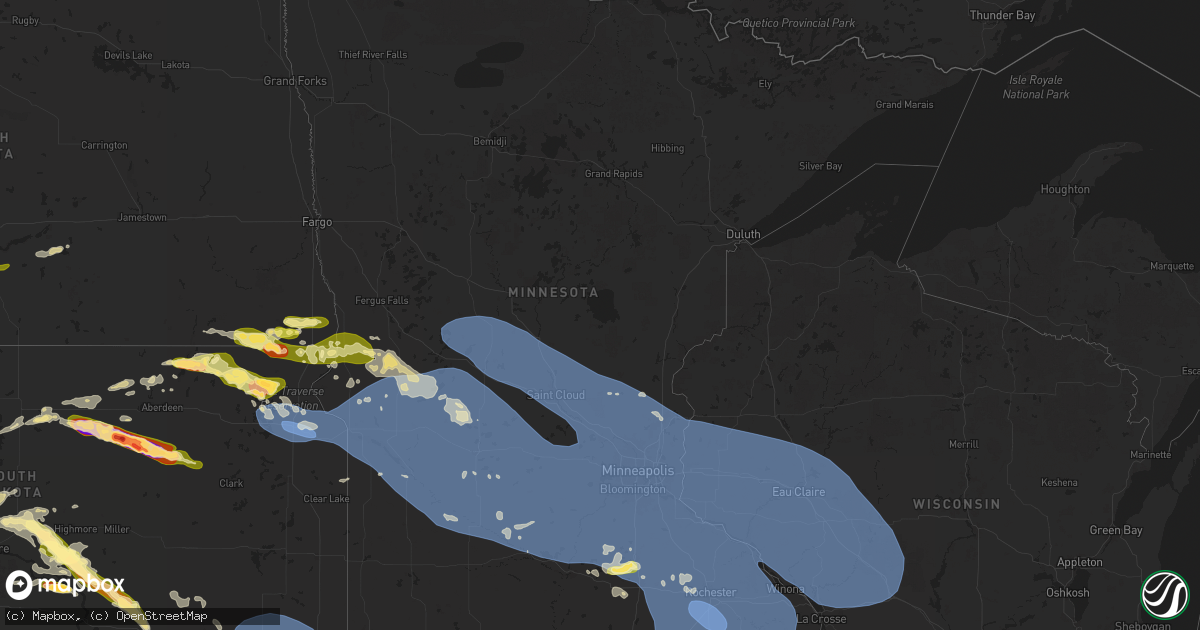
Hail Map in Minnesota on July 28, 2025
Get this storm
July 28 map
$229
one time, instant access
Download today. No call, no setup
Keep the $229
Bought the map and want the full workflow? Apply the entire $229 to a subscription within 7 days. None of it is wasted.
Every map, not just this one
This buys you this map. Subscription and you get every map we run, in the markets you choose from a few cities to whole states to nationwide. Plus real-time alerts the moment a storm fires.
Contact data
Name, contact info, occupancy, even credit band for addresses in the footprint. You go from where it hit to who to call.
Become the source they trust
Unlimited branding weather history reports on demand. You already have the documented answer ready for the property owner, and you are the one who showed up with it.
Property data and RoofTrace estimates
Pull up any address you have got, its value and the exact code rules for that jurisdiction, straight from One Click Code. Then RoofTrace estimates the squares, pitch, and roof value, priced the way you price.
Storm reports in Minnesota
Minnesota
| Date | Description |
|---|---|
| 07/28/202512:03 AM CDT | Numerous trees down. Pictures. Radar estimated time. |
| 07/28/202512:00 AM CDT | Mesonet station mn065 t.h.52 - canton - mp 2. |
| 07/28/202512:00 AM CDT | Several trees down. |
| 07/27/202511:50 PM CDT | Awos station kfka preston airport. |
| 07/27/202511:45 PM CDT | Shed destroyed by downed trees. Picture. Radar time estimated. |
| 07/27/202511:35 PM CDT | Numerous trees down. Time estimated from radar. |
| 07/27/202511:30 PM CDT | Mesonet station mn144 u.s.218 - lyle - mp 4. |
| 07/27/202511:20 PM CDT | Asos station krst rochester international airport. |
| 07/27/202511:15 PM CDT | Awos station k9mn mayo helipad. |
| 07/27/202511:12 PM CDT | 10 inch diameter limb of healthy tree snapped about 25 above ground. |
| 07/27/202511:10 PM CDT | Soft and hardwood trees downed. Time estimated on radar. |
| 07/27/202511:08 PM CDT | 8 inch diameter tree limb snapped. |
| 07/27/202511:05 PM CDT | Mesonet station mn029 u.s.14 - byron - mp 200. |
| 07/27/202511:00 PM CDT | Mesonet station mn143 u.s.63 - lake city - mp 62.9. |
| 07/27/202510:50 PM CDT | Tree down across cassandra st. |
| 07/27/202510:40 PM CDT | Measured at owatonna airport. |
| 07/27/202510:30 PM CDT | 8-10 inch tree snapped. |
| 07/27/202510:27 PM CDT | At faribault airport. A three inch diameter tree was reported down near the airport. |
| 07/27/202510:25 PM CDT | A local report indicates 1.25 inch wind near 1 S Morristown |
| 07/27/202510:12 PM CDT | Report of multiple trees down near the high school in montgomery. Time estimated via radar. |
| 07/27/202510:10 PM CDT | Large healthy pine tree snapped about 15 feet above ground... With its top resting on a house. This was near the intersection of 3rd street ne and linden avenue. Large |
| 07/27/202510:05 PM CDT | Report of downed power lines near highway 3 in rosemount. Time estimated from radar. |
| 07/27/202510:02 PM CDT | Measured at cr27 and longview. |
| 07/27/202510:00 PM CDT | Large tree down |
| 07/27/20259:56 PM CDT | Measured by scott county mesonet. |
| 07/27/20259:56 PM CDT | Corrects previous tstm wnd gst report from 3 nnw new prague. Measured by scott county mesonet. |
| 07/27/20259:56 PM CDT | Large tree snapped in belle plaine. Photo report via x. Time estimated radar. |
| 07/27/20259:55 PM CDT | Large tree downed in eden prairie. Photo report via x. |
| 07/27/20259:55 PM CDT | Report of downed maple tree in backyard. |
| 07/27/20259:54 PM CDT | A local report indicates 62 MPH wind near Savage |
| 07/27/20259:50 PM CDT | Tree down on southview blvd near hwy 52. |
| 07/27/20259:50 PM CDT | Three to four inch branches broken off of healthy trees. Time estimated based on radar. |
| 07/27/20259:49 PM CDT | Measured by scott county mesonet. |
| 07/27/20259:47 PM CDT | Measured at msp airport. |
| 07/27/20259:45 PM CDT | Trees down... Including some on valley view rd. Time estimated based on radar. |
| 07/27/20259:45 PM CDT | Measured by meteorologist. |
| 07/27/20259:40 PM CDT | Two trees down on the north side of white bear lake. |
| 07/27/20259:30 PM CDT | Large tree down approximately 18 inches in diameter. Near 85th ave and spring lake road in mounds view. Time estimated based on radar. |
| 07/27/20259:30 PM CDT | Tree down across much of main st at 37th. Time estimated based on radar. |
| 07/27/20259:30 PM CDT | Corrects previous tstm wnd dmg report from 2 n coon rapids. 8-10 inch tree snapped. Time estimated by radar. |
| 07/27/20259:29 PM CDT | 12 inch diameter tree snapped at the base. |
| 07/27/20259:29 PM CDT | Glencoe airport. |
| 07/27/20259:18 PM CDT | Tree down on house. Time estimated based on radar. |
| 07/27/20259:10 PM CDT | Ten inch tree broken. |
| 07/27/20259:09 PM CDT | Hutchinson airport. |
| 07/27/20258:10 PM CDT | Multiple trees down... Trunks split at base. Pictures via social media. Time estimated via radar. |
| 07/27/20257:20 PM CDT | Along cr 29 north of mill lake. Portion of a roof of a shed blown off. Fish house blown around. Relayed by county dispatch. |
| 07/27/20257:20 PM CDT | Mesonet station mn137 u.s.75 - ortonville - mp 132.7. |
| 07/27/20257:15 PM CDT | Awos station kvvv ortonville muni ap. |
All States Impacted by Hail Map on July 28, 2025
Cities Impacted by Hail Map on July 28, 2025
- Beach, ND
- Medora, ND
- Fairfield, ND
- Sentinel Butte, ND
- Belfield, ND
- Manning, ND
- Dickinson, ND
- Killdeer, ND
- Gladstone, ND
- Amidon, ND
- Taylor, ND
- Richardton, ND
- Hebron, ND
- Glen Ullin, ND
- Ismay, MT
- Fallon, MT
- Miles City, MT
- Regent, ND
- Elgin, ND
- Almont, ND
- Mott, ND
- Carson, ND
- Plevna, MT
- New Salem, ND
- Flasher, ND
- Solen, ND
- Mandan, ND
- Saint Anthony, ND
- Hazelton, ND
- Linton, ND
- Moffit, ND
- Bismarck, ND
- Braddock, ND
- Napoleon, ND
- Steele, ND
- Dawson, ND
- Kintyre, ND
- Tappen, ND
- Streeter, ND
- Chicago, IL
- Edgefield, SC
- Modoc, SC
- Romulus, MI
- Gibson, GA
- Louisville, GA
- Saint Petersburg, FL
- Augusta, MT
- Wrens, GA
- Ideal, SD
- Clancy, MT
- Tuthill, SD
- Saint Francis, SD
- Stanford, MT
- Pierre, SD
- Witten, SD
- East Helena, MT
- Winston, MT
- Moccasin, MT
- Hamill, SD
- Selby, SD
- Onida, SD
- Eagle Butte, SD
- Agar, SD
- Parrish, FL
- Palmetto, FL
- Ellenton, FL
- Council, NC
- Bolton, NC
- Lake Waccamaw, NC
- Blunt, SD
- Akaska, SD
- Java, SD
- Bowdle, SD
- Crumpler, NC
- Harrold, SD
- Gregory, SD
- Winner, SD
- Burke, SD
- White Sulphur Springs, MT
- Hoven, SD
- Carrizozo, NM
- Hosmer, SD
- Orlando, FL
- Windermere, FL
- Oakes, ND
- Frederick, SD
- Hecla, SD
- Dexter, GA
- Rentz, GA
- Dublin, GA
- Mission, SD
- Roscoe, SD
- Cascade, MT
- Helena, MT
- Valentine, NE
- Holabird, SD
- Moore, MT
- Lewistown, MT
- Cogswell, ND
- Highmore, SD
- Tawas City, MI
- Turner, MI
- National City, MI
- Whittemore, MI
- Leola, SD
- Ipswich, SD
- Great Falls, MT
- Stockett, MT
- Sun River, MT
- Hobson, MT
- Platte, SD
- Stephan, SD
- Fort Thompson, SD
- Houghton, SD
- Havana, ND
- Forman, ND
- Rutland, ND
- Westport, SD
- Au Gres, MI
- Claremont, SD
- Britton, SD
- Amherst, SD
- Lidgerwood, ND
- Cayuga, ND
- Veblen, SD
- Claire City, SD
- Hankinson, ND
- Wyndmere, ND
- Mantador, ND
- Wahpeton, ND
- Fairmount, ND
- Waynesboro, TN
- Monarch, MT
- Belt, MT
- Lithia, FL
- Aberdeen, SD
- Crookston, NE
- Wood Lake, NE
- Hyannis, NE
- Whitman, NE
- Coffee Creek, MT
- Clifton, TN
- Cresbard, SD
- Florence, AL
- Faulkton, SD
- Columbia, SD
- Springview, NE
- Gann Valley, SD
- Saint Matthews, SC
- Swansea, SC
- Ree Heights, SD
- Ashland, OH
- Polk, OH
- West Salem, OH
- Memphis, IN
- Henryville, IN
- Raynesford, MT
- Buffalo, MT
- Colome, SD
- Herrick, SD
- Saint Charles, SD
- Mansfield, SD
- Denton, MT
- North, SC
- McRae Helena, GA
- New Effington, SD
- Dallas, SD
- Langford, SD
- Riverview, FL
- Charlestown, IN
- Northville, SD
- Haines, OR
- Fairfax, SD
- Geddes, SD
- Bonesteel, SD
- Kimball, SD
- Geraldine, MT
- Mellette, SD
- Rosholt, SD
- Lumber City, GA
- Wooster, OH
- Geyser, MT
- Eden, SD
- Lake City, SD
- Roslyn, SD
- Alamo, GA
- Brentford, SD
- Ashton, SD
- Forest Grove, MT
- Sisseton, SD
- Grenville, SD
- Judith Gap, MT
- Wheaton, MN
- Tintah, MN
- Campbell, MN
- Elbow Lake, MN
- Norcross, MN
- Herman, MN
- Marysville, MT
- Washington, IN
- Muscle Shoals, AL
- Thonotosassa, FL
- Waubay, SD
- Webster, SD
- Mills, NE
- White Lake, SD
- Lake Andes, SD
- Lavina, MT
- Wessington Springs, SD
- Peever, SD
- Imnaha, OR
- Lower Brule, SD
- Pinconning, MI
- Linwood, MI
- Conde, SD
- Zephyrhills, FL
- Vincennes, IN
- Turton, SD
- Summit, SD
- Wilmot, SD
- Ortley, SD
- Marvin, SD
- South Shore, SD
- Corona, SD
- Twin Brooks, SD
- Ortonville, MN
- Clinton, MN
- Milbank, SD
- Ryegate, MT
- Big Sandy, MT
- Highwood, MT
- Dumont, MN
- Deer Lodge, MT
- Garrison, MT
- Pickstown, SD
- Woonsocket, SD
- Grass Range, MT
- Kennebec, SD
- Chamberlain, SD
- Wagner, SD
- Donnelly, MN
- Barrett, MN
- Depauw, IN
- Naper, NE
- Kawkawlin, MI
- Corydon, IN
- Ramsey, IN
- Roundup, MT
- Atkinson, NE
- Butte, NE
- Stuart, NE
- Chokio, MN
- Big Stone City, SD
- Graceville, MN
- Morris, MN
- Alberta, MN
- Cyrus, MN
- Correll, MN
- Holloway, MN
- Madison, MN
- Marietta, MN
- Bellingham, MN
- Odessa, MN
- Hancock, MN
- Appleton, MN
- Carlos, MN
- Alexandria, MN
- Nelson, MN
- Parkers Prairie, MN
- Long Prairie, MN
- Browerville, MN
- Clarissa, MN
- Eagle Bend, MN
- Miltona, MN
- Osakis, MN
- Grey Eagle, MN
- Sauk Centre, MN
- Cushing, MN
- Randall, MN
- Swanville, MN
- Burtrum, MN
- Little Falls, MN
- Freeport, MN
- Melrose, MN
- Flensburg, MN
- Bowlus, MN
- Shawmut, MT
- Wheatland, IN
- Hoffman, MN
- Kensington, MN
- Farwell, MN
- Two Dot, MT
- Letcher, SD
- Artesian, SD
- Johnstown, NE
- Montgomery, IN
- Starbuck, MN
- Villard, MN
- Lowry, MN
- Danvers, MN
- Glenwood, MN
- Benson, MN
- Clontarf, MN
- Milan, MN
- Model, CO
- Ainsworth, NE
- Tuscumbia, AL
- Armour, SD
- Lynch, NE
- Spencer, NE
- Bristow, NE
- Delmont, SD
- Tripp, SD
- Scotland, SD
- Avon, SD
- Dante, SD
- Tyndall, SD
- Olivet, SD
- Kaylor, SD
- Lesterville, SD
- Tabor, SD
- Oneill, NE
- Long Pine, NE
- Eastover, SC
- Springfield, GA
- Bend, OR
- Harlowton, MT
- Fulton, SD
- Mitchell, SD
- Richland, IN
- Verdigre, NE
- Niobrara, NE
- Menno, SD
- Freeman, SD
- Yankton, SD
- Viborg, SD
- Mission Hill, SD
- Irene, SD
- Utica, SD
- Holdingford, MN
- Royalton, MN
- Upsala, MN
- Presho, SD
- Chrisney, IN
- Albany, MN
- Rice, MN
- Avon, MN
- Saint Joseph, MN
- Saint Stephen, MN
- Rockport, IN
- Bassett, NE
- Rincon, GA
- Kerkhoven, MN
- Atwater, MN
- Murdock, MN
- Richmond, MN
- Spicer, MN
- Willmar, MN
- Dawson, MN
- Montevideo, MN
- Elrosa, MN
- New London, MN
- Watson, MN
- Pennock, MN
- Eden Valley, MN
- Brooten, MN
- Belgrade, MN
- Roscoe, MN
- Sunburg, MN
- Paynesville, MN
- Granite Falls, MN
- Maynard, MN
- Clara City, MN
- Sacred Heart, MN
- Kandiyohi, MN
- Clarkfield, MN
- Boyd, MN
- Grove City, MN
- Blomkest, MN
- Prinsburg, MN
- Renville, MN
- Wood Lake, MN
- Hanley Falls, MN
- Raymond, MN
- Echo, MN
- Ellabell, GA
- Dorchester, SC
- Harleyville, SC
- Newport, NE
- Avon, MT
- Eastview, KY
- Guyton, GA
- Ridgeland, SC
- Hardeeville, SC
- Petersburg, IN
- Owensboro, KY
- Princeton, MN
- Harlem, MT
- Ridgeville, SC
- Utica, KY
- Marion, SD
- Canistota, SD
- Crooks, SD
- Baltic, SD
- Hartford, SD
- Monroe, SD
- Montrose, SD
- Hurley, SD
- Colton, SD
- Lyons, SD
- Parker, SD
- Chancellor, SD
- Humboldt, SD
- Volin, SD
- Bridgewater, SD
- Emery, SD
- Alexandria, SD
- Winfred, SD
- Spencer, SD
- Salem, SD
- Tea, SD
- Sioux Falls, SD
- Renner, SD
- Lennox, SD
- Davis, SD
- Harrisburg, SD
- Centerville, SD
- Brandon, SD
- Worthing, SD
- Larchwood, IA
- Canton, SD
- Burbank, SD
- Alcester, SD
- Vermillion, SD
- Elk Point, SD
- Wakonda, SD
- Beresford, SD
- Hudson, SD
- Cokato, MN
- Litchfield, MN
- Morton, MN
- Bird Island, MN
- Fairfax, MN
- Silver Lake, MN
- Hector, MN
- Belview, MN
- Olivia, MN
- Glencoe, MN
- Danube, MN
- Hutchinson, MN
- Lake Lillian, MN
- Buffalo Lake, MN
- Winthrop, MN
- New Auburn, MN
- Cosmos, MN
- Kimball, MN
- Brownton, MN
- Stewart, MN
- Darwin, MN
- Franklin, MN
- Gaylord, MN
- Gibbon, MN
- Watkins, MN
- Redwood Falls, MN
- Dassel, MN
- Morgan, MN
- Sleepy Eye, MN
- Seaforth, MN
- Wabasso, MN
- Vesta, MN
- Springfield, SD
- Cambridge, MN
- Riverside, OR
- Gary, SD
- Clyo, GA
- Crofton, NE
- Tillman, SC
- Hamburg, MN
- Arlington, MN
- Winsted, MN
- Plato, MN
- Lester Prairie, MN
- Green Isle, MN
- Norwood Young America, MN
- South Haven, MN
- Howard Lake, MN
- Waverly, MN
- Mayer, MN
- New Germany, MN
- Young America, MN
- Hills, MN
- Lester, IA
- Rock Rapids, IA
- Steen, MN
- Valley Springs, SD
- Inwood, IA
- Alvord, IA
- Westfield, IA
- Merrill, IA
- Hawarden, IA
- Chatsworth, IA
- Fairview, SD
- Doon, IA
- Hull, IA
- Le Mars, IA
- Sioux Center, IA
- Ireton, IA
- Akron, IA
- Rock Valley, IA
- Ingomar, MT
- Musselshell, MT
- Melstone, MT
- Custer, MT
- Forsyth, MT
- Worden, MT
- Hysham, MT
- Winnett, MT
- Orange City, IA
- Boyden, IA
- Maurice, IA
- Alton, IA
- George, IA
- Granville, IA
- Remsen, IA
- Hospers, IA
- Brunsville, IA
- Sheldon, IA
- Sparks, NV
- Annandale, MN
- Virginia City, NV
- Hamel, MN
- Buffalo, MN
- Rockford, MN
- Delano, MN
- Montrose, MN
- Maple Lake, MN
- Loretto, MN
- Elk River, MN
- Becker, MN
- Maple Grove, MN
- Monticello, MN
- Hanover, MN
- Saint Michael, MN
- Saint Cloud, MN
- Osseo, MN
- Albertville, MN
- Zimmerman, MN
- Clearwater, MN
- Big Lake, MN
- Rogers, MN
- Anoka, MN
- Waite Park, MN
- Clear Lake, MN
- Cold Spring, MN
- Dayton, MN
- Sartell, MN
- Sauk Rapids, MN
- Foley, MN
- Saint Francis, MN
- Oak Park, MN
- Milaca, MN
- Pierz, MN
- Foreston, MN
- Center City, MN
- Stacy, MN
- Isanti, MN
- Lindstrom, MN
- Chisago City, MN
- North Branch, MN
- Cedar, MN
- Dalbo, MN
- Stanchfield, MN
- Pease, MN
- Bethel, MN
- New Richmond, WI
- Scandia, MN
- Andover, MN
- Star Prairie, WI
- Forest Lake, MN
- Shafer, MN
- Osceola, WI
- Somerset, WI
- Marine On Saint Croix, MN
- Wyoming, MN
- Hammond, WI
- Hugo, MN
- Baldwin, WI
- Stillwater, MN
- Minneapolis, MN
- Saint Paul, MN
- Houlton, WI
- Bayport, MN
- Hudson, WI
- Circle Pines, MN
- Roberts, WI
- Willernie, MN
- Champlin, MN
- Waconia, MN
- Maple Plain, MN
- Hopkins, MN
- Watertown, MN
- Lakeland, MN
- Minnetonka, MN
- Long Lake, MN
- Wayzata, MN
- Lake Elmo, MN
- Saint Bonifacius, MN
- Excelsior, MN
- Mound, MN
- Spring Park, MN
- Mendota, MN
- Le Center, MN
- Saint Paul Park, MN
- Victoria, MN
- Henderson, MN
- Newport, MN
- Belle Plaine, MN
- Elko New Market, MN
- Burnsville, MN
- Prior Lake, MN
- South Saint Paul, MN
- Le Sueur, MN
- Savage, MN
- Carver, MN
- Cologne, MN
- Cleveland, MN
- Rosemount, MN
- Webster, MN
- Shakopee, MN
- New Prague, MN
- Farmington, MN
- Hastings, MN
- Cottage Grove, MN
- Afton, MN
- Lakeville, MN
- Chaska, MN
- Inver Grove Heights, MN
- Jordan, MN
- Eden Prairie, MN
- River Falls, WI
- Chanhassen, MN
- Montgomery, MN
- Lonsdale, MN
- Madison Lake, MN
- Nicollet, MN
- Kasota, MN
- Saint Peter, MN
- Lafayette, MN
- Mankato, MN
- Courtland, MN
- New Ulm, MN
- Springfield, MN
- Woodville, WI
- Northfield, MN
- Hampton, MN
- Vermillion, MN
- Elysian, MN
- Prescott, WI
- Kilkenny, MN
- Waterville, MN
- Sanborn, MN
- Rosebud, MT
- Molt, MT
- Billings, MT
- Shepherd, MT
- Acton, MT
- Granada, MN
- Fairmont, MN
- Park City, MT
- Eagle Lake, MN
- Absarokee, MT
- Janesville, MN
- Laurel, MT
- Wilson, WI
- Glenwood City, WI
- Beldenville, WI
- Randolph, MN
- Dundas, MN
- Knapp, WI
- Menomonie, WI
- Ellsworth, WI
- Hager City, WI
- Cannon Falls, MN
- Faribault, MN
- Welch, MN
- Spring Valley, WI
- Amery, WI
- Elmwood, WI
- Deer Park, WI
- Downing, WI
- Boyceville, WI
- Worthington, MN
- Bigelow, MN
- Little Rock, IA
- Sanborn, IA
- Matlock, IA
- Lake Park, IA
- Harris, IA
- Round Lake, MN
- Ashton, IA
- Primghar, IA
- Sibley, IA
- Spirit Lake, IA
- Melvin, IA
- Archer, IA
- Rushmore, MN
- Hartley, IA
- Ocheyedan, IA
- Lakefield, MN
- Adrian, MN
- Estherville, IA
- Jackson, MN
- Alpha, MN
- Okoboji, IA
- Dunnell, MN
- Milford, IA
- Everly, IA
- Kenyon, MN
- Dennison, MN
- Goodhue, MN
- Maiden Rock, WI
- Red Wing, MN
- Zumbrota, MN
- Owatonna, MN
- Bay City, WI
- Nerstrand, MN
- Morristown, MN
- Waseca, MN
- Warsaw, MN
- Medford, MN
- Spencer, IA
- Meriden, IA
- Truesdale, IA
- Superior, IA
- Fostoria, IA
- Sutherland, IA
- Calumet, IA
- Storm Lake, IA
- Early, IA
- Royal, IA
- Aurelia, IA
- Arnolds Park, IA
- Linn Grove, IA
- Albert City, IA
- Gillett Grove, IA
- Cherokee, IA
- Schaller, IA
- Greenville, IA
- Ruthven, IA
- Rembrandt, IA
- Peterson, IA
- Webb, IA
- Cleghorn, IA
- Nemaha, IA
- Terril, IA
- Galva, IA
- Marathon, IA
- Dickens, IA
- Larrabee, IA
- Paullina, IA
- Sioux Rapids, IA
- Alta, IA
- Marcus, IA
- Kingsley, IA
- Holstein, IA
- Washta, IA
- Quimby, IA
- Pierson, IA
- Oyens, IA
- Blue Earth, MN
- Columbus, MT
- Reed Point, MT
- Elmore, MN
- Huntley, MT
- Elk Mound, WI
- Pepin, WI
- Durand, WI
- West Concord, MN
- Mondovi, WI
- Plum City, WI
- Stockholm, WI
- Wanamingo, MN
- Eau Claire, WI
- Lake City, MN
- Frontenac, MN
- Eau Galle, WI
- Arkansaw, WI
- Nelson, WI
- Waltham, MN
- Elgin, MN
- Claremont, MN
- Mantorville, MN
- Blooming Prairie, MN
- Millville, MN
- Hayfield, MN
- Mazeppa, MN
- Oronoco, MN
- Austin, MN
- Zumbro Falls, MN
- Rochester, MN
- Kasson, MN
- Reads Landing, MN
- Byron, MN
- Kellogg, MN
- Wabasha, MN
- Pine Island, MN
- Dodge Center, MN
- Ellendale, MN
- Ayrshire, IA
- Curlew, IA
- Mallard, IA
- Emmetsburg, IA
- Cylinder, IA
- Ballantine, MT
- Big Timber, MT
- Graettinger, IA
- Roberts, MT
- Wallingford, IA
- Joliet, MT
- Rake, IA
- Buffalo Center, IA
- Algona, IA
- Fenton, IA
- Ringsted, IA
- Whittemore, IA
- West Bend, IA
- Swea City, IA
- Ledyard, IA
- Lu Verne, IA
- Colfax, WI
- New Auburn, WI
- Ridgeland, WI
- Wheeler, WI
- Bloomer, WI
- Dresser, WI
- Clear Lake, WI
- Chetek, WI
- Dallas, WI
- Clayton, WI
- Prairie Farm, WI
- Rome, GA
- Sargeant, MN
- Spring Valley, MN
- Dexter, MN
- Chatfield, MN
- Racine, MN
- Stewartville, MN
- Grand Meadow, MN
- Fall Creek, WI
- Augusta, WI
- Thorp, WI
- Stanley, WI
- Boyd, WI
- Cadott, WI
- Chippewa Falls, WI
- Jim Falls, WI
- Cochrane, WI
- Whitehall, WI
- Saint Charles, MN
- Arcadia, WI
- Greenwood, WI
- Willard, WI
- Alma, WI
- Strum, WI
- Osseo, WI
- Altura, MN
- Fairchild, WI
- Brownsdale, MN
- Eyota, MN
- Eleva, WI
- Plainview, MN
- Independence, WI
- Altoona, WI
- Wykoff, MN
- Elkton, MN
- Minnesota City, MN
- Ostrander, MN
- Dover, MN
- Fountain City, WI
- Winona, MN
- Humbird, WI
- Rollingstone, MN
- Lewiston, MN
- Blair, WI
- Utica, MN
- Hixton, WI
- Alma Center, WI
- Fountain, MN
- Dodge, WI
- Lansing, MN
- Varina, IA
- Armstrong, IA
- Burt, IA
- Wesley, IA
- Ottosen, IA
- Forest City, IA
- Thompson, IA
- Leland, IA
- Woden, IA
- Ceylon, MN
- Newell, IA
- Havelock, IA
- Fonda, IA
- Plover, IA
- Laurens, IA
- Lakota, IA
- Titonka, IA
- Dolliver, IA
- Rolfe, IA
- Pocahontas, IA
- Britt, IA
- Lone Rock, IA
- Bancroft, IA
- Scranton, IA
- Rockwell City, IA
- Goldfield, IA
- Renwick, IA
- Crystal Lake, IA
- Moorland, IA
- Fort Dodge, IA
- Dakota City, IA
- Jefferson, IA
- Sac City, IA
- Lake City, IA
- Bode, IA
- Barnum, IA
- Clare, IA
- Paton, IA
- Rutland, IA
- Pomeroy, IA
- Manson, IA
- Garner, IA
- Callender, IA
- Auburn, IA
- Gowrie, IA
- Lohrville, IA
- Thor, IA
- Palmer, IA
- Livermore, IA
- Knierim, IA
- Badger, IA
- Churdan, IA
- Lytton, IA
- Jolley, IA
- Hardy, IA
- Farnhamville, IA
- Corwith, IA
- Somers, IA
- Gilmore City, IA
- Bradgate, IA
- Humboldt, IA
- Kanawha, IA
- Lanesboro, IA
- Glidden, IA
- Brockway, MT
- Terry, MT
- Circle, MT
- Lindsay, MT
- Bloomfield, MT
- Glendive, MT
- Bonanza, OR
- Edgar, MT
- Vincent, IA
- Joice, IA
- Lake Mills, IA
- Eagle Grove, IA
- Otho, IA
- Peterson, MN
- Preston, MN
- Lanesboro, MN
- Rushford, MN
- Galesville, WI
- Trempealeau, WI
- Taylor, WI
- Ettrick, WI
- Dana, IA
- Harcourt, IA
- Woolstock, IA
- Fertile, IA
- Webster City, IA
- Duncombe, IA
- Boxholm, IA
- Belmond, IA
- Lehigh, IA
- Clarion, IA
- Pilot Mound, IA
- Goodell, IA
- Burnside, IA
- Ogden, IA
- Dayton, IA
- Klemme, IA
- Stratford, IA
- Scarville, IA
- Neillsville, WI
- Merrillan, WI
- Black River Falls, WI
- Holmen, WI
- Melrose, WI
- Houston, MN
- Dakota, MN
- Blairsburg, IA
- Dows, IA
- Meservey, IA
- Kensett, IA
- Rockwell, IA
- Plymouth, IA
- Rowan, IA
- Alexander, IA
- Mason City, IA
- Swaledale, IA
- Grafton, IA
- Manly, IA
- Thornton, IA
- Ventura, IA
- Galt, IA
- Boone, IA
- Hanlontown, IA
- Clear Lake, IA
- Rose Creek, MN
- Little Cedar, IA
- Saint Ansgar, IA
- Harmony, MN
- Riceville, IA
- Chester, IA
- Lyle, MN
- Taopi, MN
- Le Roy, MN
- Osage, IA
- Lime Springs, IA
- Adams, MN
- Stacyville, IA
- McIntire, IA
- Albert Lea, MN
- Jewell, IA
- Kamrar, IA
- Williams, IA
- Latimer, IA
- Sheffield, IA
- Stanhope, IA
- Pompeys Pillar, MT
- Hardin, MT
- Rockford, IA
- Nora Springs, IA
- Hampton, IA
- Warrens, WI
- Sparta, WI
- Pittsville, WI
- Mindoro, WI
- Tomah, WI
- Bangor, WI
- Granton, WI
- Norwalk, WI
- West Salem, WI
- Rockland, WI
- Onalaska, WI
- Ellsworth, IA
- Marble Rock, IA
- Floyd, IA
- Popejoy, IA
- Greene, IA
- Charles City, IA
- Alden, IA
- Elma, IA
- Rudd, IA
- Iowa Falls, IA
- Rock Falls, IA
- Aredale, IA
- Coulter, IA
- Orchard, IA
- Chapin, IA
- Dougherty, IA
- Canton, MN
- Decorah, IA
- Mabel, MN
- Spring Grove, MN
- Caledonia, MN
- Cresco, IA
- Alta Vista, IA
- Bristow, IA
- Bradford, IA
- Geneva, IA
- Colwell, IA
- Dumont, IA
- Story City, IA
- Allison, IA
- Radcliffe, IA
- New Providence, IA
- Ionia, IA
- Eldora, IA
- Steamboat Rock, IA
- Nashua, IA
- Clarksville, IA
- Ackley, IA
- Aplington, IA
- Hubbard, IA
- Austinville, IA
- Garden City, IA
- Kesley, IA
- Ridgeway, IA
- Waucoma, IA
- Calmar, IA
- Fort Atkinson, IA
- Protivin, IA
- Lawler, IA
- New Hampton, IA
- Randall, IA
- Waverly, IA
- Plainfield, IA
- Fredericksburg, IA
- Frederika, IA
- Sumner, IA
- Tripoli, IA
- Union, IA
- Conrad, IA
- Cedar Falls, IA
- Beaman, IA
- Parkersburg, IA
- Shell Rock, IA
- Wellsburg, IA
- Spillville, IA
- Hawkeye, IA
- Liscomb, IA
- Grundy Center, IA
- Denver, IA
- Reinbeck, IA
- Janesville, IA
- Dunkerton, IA
- Lincoln, IA
- Traer, IA
- Hudson, IA
- Dike, IA
- Montour, IA
- New Hartford, IA
- Waterloo, IA
- Gladbrook, IA
- Albion, IA
- Whitten, IA
- Morrison, IA
- Readlyn, IA
- Garwin, IA
- Stout, IA
- Marshalltown, IA
- Toledo, IA
- Holland, IA
- Clemons, IA
- Fairbank, IA
- Evansdale, IA
- Gilbertville, IA
- Dewar, IA
- Independence, IA
- Jesup, IA
- Raymond, IA
- Brandon, IA
- La Porte City, IA
- West Union, IA
- Randalia, IA
- Dysart, IA
- Maynard, IA
- Buckingham, IA
- Hazleton, IA
- Clutier, IA
- Saint Lucas, IA
- Oran, IA
- Oelwein, IA
- Westgate, IA
- Melbourne, IA
- State Center, IA
- Baxter, IA
- Bighorn, MT
- Arlington, IA
- Fayette, IA
- Stanley, IA
- Elgin, IA
- Wadena, IA
- Ossian, IA
- Clermont, IA
- Elberon, IA
- Mount Auburn, IA
- Garrison, IA
- Chelsea, IA
- Vining, IA
- Vinton, IA
- Tama, IA
- Keystone, IA
- Aurora, IA
- Sully, IA
- Kellogg, IA
- Newton, IA
- Winthrop, IA
- Haverhill, IA
- Laurel, IA
- Grinnell, IA
- Masonville, IA
- Lamont, IA
- Gilman, IA
- Belle Plaine, IA
- Hartwick, IA
- Brooklyn, IA
- Malcom, IA
- Marengo, IA
- Barnes City, IA
- Killduff, IA
- Searsboro, IA
- Montezuma, IA
- Deep River, IA
- Guernsey, IA
- New Sharon, IA
- Victor, IA
- Lynnville, IA
- Reasnor, IA
- Ladora, IA
- Volga, IA
- Elkport, IA
- Guttenberg, IA
- Edgewood, IA
- Elkader, IA
- Strawberry Point, IA
- Garnavillo, IA
- Garber, IA
- Manchester, IA
- Rowley, IA
- Dundee, IA
- Delaware, IA
- Ryan, IA
- Cedar Rapids, IA
- Tiffin, IA
- Earlville, IA
- Quasqueton, IA
- Oxford, IA
- Ely, IA
- Alburnett, IA
- North Liberty, IA
- Urbana, IA
- Center Point, IA
- Robins, IA
- Walker, IA
- Coggon, IA
- Central City, IA
- Greeley, IA
- Atkins, IA
- Toddville, IA
- Solon, IA
- Palo, IA
- Swisher, IA
- Hiawatha, IA
- Hopkinton, IA
- Monticello, IA
- Anamosa, IA
- New Vienna, IA
- Delhi, IA
- Iowa City, IA
- Shellsburg, IA
- Marion, IA
- Prairieburg, IA
- Springville, IA
- Coralville, IA
- Colesburg, IA
- Mount Vernon, IA
- Dyersville, IA
- Fairfax, IA
- Amana, IA
- South Amana, IA
- Walford, IA
- Watkins, IA
- Norway, IA
- Middle Amana, IA
- Homestead, IA
- Newhall, IA
- Blairstown, IA
- Van Horne, IA
- Luzerne, IA
- Colstrip, MT
- Decker, MT
- Birney, MT
- North English, IA
- Gibson, IA
- Worthington, IA
- Bernard, IA
- Farley, IA
- Durango, IA
- North Buena Vista, IA
- Epworth, IA
- Cassville, WI
- Lisbon, IA
- Sherrill, IA
- Holy Cross, IA
- Martelle, IA
- Cascade, IA
- Glen Haven, WI
- Dubuque, IA
- Langworthy, IA
- Peosta, IA
- Luxemburg, IA
- Center Junction, IA
- Morley, IA
- Stanwood, IA
- Oxford Junction, IA
- West Branch, IA
- Andrew, IA
- Spragueville, IA
- Onslow, IA
- Lost Nation, IA
- Bellevue, IA
- Tipton, IA
- Donahue, IA
- La Motte, IA
- Wyoming, IA
- Olin, IA
- New Liberty, IA
- Wheatland, IA
- De Witt, IA
- Dixon, IA
- Zwingle, IA
- Monmouth, IA
- Mechanicsville, IA
- Grand Mound, IA
- Bennett, IA
- Maquoketa, IA
- Baldwin, IA
- Clarence, IA
- Lowden, IA
- Stockton, IA
- Calamus, IA
- Delmar, IA
- Atalissa, IA
- Wilton, IA
- West Liberty, IA
- Moscow, IA
- Potosi, WI
- Crow Agency, MT
- Long Grove, IA
- Clinton, IA
- Miles, IA
- Goose Lake, IA
- Charlotte, IA
- Bryant, IA
- Preston, IA
- Welton, IA
- Walcott, IA
- Durant, IA
- Washington, IA
- Mendota, IL
- Cordova, IL
- Elwood, IL
- Deer Grove, IL
- McCausland, IA
- Shorewood, IL
- Hillsdale, IL
- Joliet, IL
- Sublette, IL
- Sheridan, IL
- Monee, IL
- Newark, IL
- Earlville, IL
- Walnut, IL
- Channahon, IL
- Leland, IL
- Princeton, IA
- Ohio, IL
- Tampico, IL
- Prophetstown, IL
- Erie, IL
- Serena, IL
- Eldridge, IA
- La Moille, IL
- Harmon, IL
- Frankfort, IL
- Manhattan, IL
- Minooka, IL
- Albany, IL
- Rock Falls, IL
- Fromberg, MT
- Bettendorf, IA
- Rock Island, IL
- Davenport, IA
- Moline, IL
- Fulton, IL
- Camanche, IA
- Port Byron, IL
- Low Moor, IA
- Hampton, IL
- Rapids City, IL
- Pleasant Valley, IA
- Le Claire, IA
- East Moline, IL
- Milan, IL
- Buffalo, IA
- Blue Grass, IA
- Taylor Ridge, IL
- Montpelier, IA
- Muscatine, IA
- Conroy, IA
- Williamsburg, IA
- Keota, IA
- Harper, IA
- Millersburg, IA
- South English, IA
- What Cheer, IA
- Keswick, IA
- Parnell, IA
- Sigourney, IA
- Webster, IA
- Wellman, IA


