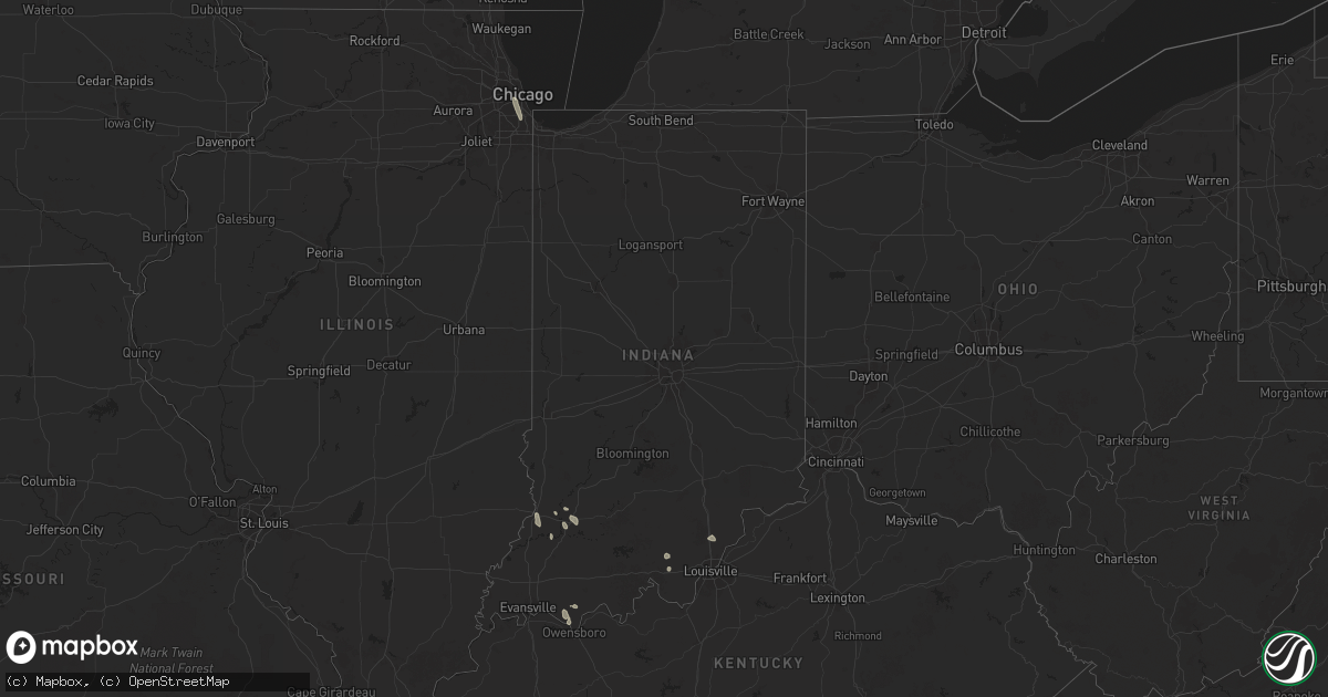
Hail Map in Indiana on July 28, 2025
Get this storm
July 28 map
$229
one time, instant access
Download today. No call, no setup
Keep the $229
Bought the map and want the full workflow? Apply the entire $229 to a subscription within 7 days. None of it is wasted.
Every map, not just this one
This buys you this map. Subscription and you get every map we run, in the markets you choose from a few cities to whole states to nationwide. Plus real-time alerts the moment a storm fires.
Contact data
Name, contact info, occupancy, even credit band for addresses in the footprint. You go from where it hit to who to call.
Become the source they trust
Unlimited branding weather history reports on demand. You already have the documented answer ready for the property owner, and you are the one who showed up with it.
Property data and RoofTrace estimates
Pull up any address you have got, its value and the exact code rules for that jurisdiction, straight from One Click Code. Then RoofTrace estimates the squares, pitch, and roof value, priced the way you price.
Storm reports in Indiana
Indiana
| Date | Description |
|---|---|
| 07/28/20256:48 PM CDT | Tree down on a transformer in otwell. |
| 07/28/20256:15 PM CDT | Numerous spots in town with trees and lines down. Roof damage to a structure on lawton street. |
| 07/28/20255:46 PM CDT | Multiple trees and power lines down in the area of 2nd... 3rd... 4th... And 5th street and market street. Time estimated from radar. |
| 07/28/20255:20 PM CDT | One tree down across the roadway at state route 62 and south cave hill road. |
| 07/27/20257:12 PM CDT | Large tree limb across highway 64... Tree on camper in oakland city. |
| 07/27/20257:12 PM CDT | Roughly 30 trees broke off about 20 ft up. At least 3 trees were uprooted. One tree hit a barn on the way down while another hit the roof of a house causing damage to a |
All States Impacted by Hail Map on July 28, 2025
Cities Impacted by Hail Map on July 28, 2025
- Beach, ND
- Medora, ND
- Fairfield, ND
- Sentinel Butte, ND
- Belfield, ND
- Manning, ND
- Dickinson, ND
- Killdeer, ND
- Gladstone, ND
- Amidon, ND
- Taylor, ND
- Richardton, ND
- Hebron, ND
- Glen Ullin, ND
- Ismay, MT
- Fallon, MT
- Miles City, MT
- Regent, ND
- Elgin, ND
- Almont, ND
- Mott, ND
- Carson, ND
- Plevna, MT
- New Salem, ND
- Flasher, ND
- Solen, ND
- Mandan, ND
- Saint Anthony, ND
- Hazelton, ND
- Linton, ND
- Moffit, ND
- Bismarck, ND
- Braddock, ND
- Napoleon, ND
- Steele, ND
- Dawson, ND
- Kintyre, ND
- Tappen, ND
- Streeter, ND
- Chicago, IL
- Edgefield, SC
- Modoc, SC
- Romulus, MI
- Gibson, GA
- Louisville, GA
- Saint Petersburg, FL
- Augusta, MT
- Wrens, GA
- Ideal, SD
- Clancy, MT
- Tuthill, SD
- Saint Francis, SD
- Stanford, MT
- Pierre, SD
- Witten, SD
- East Helena, MT
- Winston, MT
- Moccasin, MT
- Hamill, SD
- Selby, SD
- Onida, SD
- Eagle Butte, SD
- Agar, SD
- Parrish, FL
- Palmetto, FL
- Ellenton, FL
- Council, NC
- Bolton, NC
- Lake Waccamaw, NC
- Blunt, SD
- Akaska, SD
- Java, SD
- Bowdle, SD
- Crumpler, NC
- Harrold, SD
- Gregory, SD
- Winner, SD
- Burke, SD
- White Sulphur Springs, MT
- Hoven, SD
- Carrizozo, NM
- Hosmer, SD
- Orlando, FL
- Windermere, FL
- Oakes, ND
- Frederick, SD
- Hecla, SD
- Dexter, GA
- Rentz, GA
- Dublin, GA
- Mission, SD
- Roscoe, SD
- Cascade, MT
- Helena, MT
- Valentine, NE
- Holabird, SD
- Moore, MT
- Lewistown, MT
- Cogswell, ND
- Highmore, SD
- Tawas City, MI
- Turner, MI
- National City, MI
- Whittemore, MI
- Leola, SD
- Ipswich, SD
- Great Falls, MT
- Stockett, MT
- Sun River, MT
- Hobson, MT
- Platte, SD
- Stephan, SD
- Fort Thompson, SD
- Houghton, SD
- Havana, ND
- Forman, ND
- Rutland, ND
- Westport, SD
- Au Gres, MI
- Claremont, SD
- Britton, SD
- Amherst, SD
- Lidgerwood, ND
- Cayuga, ND
- Veblen, SD
- Claire City, SD
- Hankinson, ND
- Wyndmere, ND
- Mantador, ND
- Wahpeton, ND
- Fairmount, ND
- Waynesboro, TN
- Monarch, MT
- Belt, MT
- Lithia, FL
- Aberdeen, SD
- Crookston, NE
- Wood Lake, NE
- Hyannis, NE
- Whitman, NE
- Coffee Creek, MT
- Clifton, TN
- Cresbard, SD
- Florence, AL
- Faulkton, SD
- Columbia, SD
- Springview, NE
- Gann Valley, SD
- Saint Matthews, SC
- Swansea, SC
- Ree Heights, SD
- Ashland, OH
- Polk, OH
- West Salem, OH
- Memphis, IN
- Henryville, IN
- Raynesford, MT
- Buffalo, MT
- Colome, SD
- Herrick, SD
- Saint Charles, SD
- Mansfield, SD
- Denton, MT
- North, SC
- McRae Helena, GA
- New Effington, SD
- Dallas, SD
- Langford, SD
- Riverview, FL
- Charlestown, IN
- Northville, SD
- Haines, OR
- Fairfax, SD
- Geddes, SD
- Bonesteel, SD
- Kimball, SD
- Geraldine, MT
- Mellette, SD
- Rosholt, SD
- Lumber City, GA
- Wooster, OH
- Geyser, MT
- Eden, SD
- Lake City, SD
- Roslyn, SD
- Alamo, GA
- Brentford, SD
- Ashton, SD
- Forest Grove, MT
- Sisseton, SD
- Grenville, SD
- Judith Gap, MT
- Wheaton, MN
- Tintah, MN
- Campbell, MN
- Elbow Lake, MN
- Norcross, MN
- Herman, MN
- Marysville, MT
- Washington, IN
- Muscle Shoals, AL
- Thonotosassa, FL
- Waubay, SD
- Webster, SD
- Mills, NE
- White Lake, SD
- Lake Andes, SD
- Lavina, MT
- Wessington Springs, SD
- Peever, SD
- Imnaha, OR
- Lower Brule, SD
- Pinconning, MI
- Linwood, MI
- Conde, SD
- Zephyrhills, FL
- Vincennes, IN
- Turton, SD
- Summit, SD
- Wilmot, SD
- Ortley, SD
- Marvin, SD
- South Shore, SD
- Corona, SD
- Twin Brooks, SD
- Ortonville, MN
- Clinton, MN
- Milbank, SD
- Ryegate, MT
- Big Sandy, MT
- Highwood, MT
- Dumont, MN
- Deer Lodge, MT
- Garrison, MT
- Pickstown, SD
- Woonsocket, SD
- Grass Range, MT
- Kennebec, SD
- Chamberlain, SD
- Wagner, SD
- Donnelly, MN
- Barrett, MN
- Depauw, IN
- Naper, NE
- Kawkawlin, MI
- Corydon, IN
- Ramsey, IN
- Roundup, MT
- Atkinson, NE
- Butte, NE
- Stuart, NE
- Chokio, MN
- Big Stone City, SD
- Graceville, MN
- Morris, MN
- Alberta, MN
- Cyrus, MN
- Correll, MN
- Holloway, MN
- Madison, MN
- Marietta, MN
- Bellingham, MN
- Odessa, MN
- Hancock, MN
- Appleton, MN
- Carlos, MN
- Alexandria, MN
- Nelson, MN
- Parkers Prairie, MN
- Long Prairie, MN
- Browerville, MN
- Clarissa, MN
- Eagle Bend, MN
- Miltona, MN
- Osakis, MN
- Grey Eagle, MN
- Sauk Centre, MN
- Cushing, MN
- Randall, MN
- Swanville, MN
- Burtrum, MN
- Little Falls, MN
- Freeport, MN
- Melrose, MN
- Flensburg, MN
- Bowlus, MN
- Shawmut, MT
- Wheatland, IN
- Hoffman, MN
- Kensington, MN
- Farwell, MN
- Two Dot, MT
- Letcher, SD
- Artesian, SD
- Johnstown, NE
- Montgomery, IN
- Starbuck, MN
- Villard, MN
- Lowry, MN
- Danvers, MN
- Glenwood, MN
- Benson, MN
- Clontarf, MN
- Milan, MN
- Model, CO
- Ainsworth, NE
- Tuscumbia, AL
- Armour, SD
- Lynch, NE
- Spencer, NE
- Bristow, NE
- Delmont, SD
- Tripp, SD
- Scotland, SD
- Avon, SD
- Dante, SD
- Tyndall, SD
- Olivet, SD
- Kaylor, SD
- Lesterville, SD
- Tabor, SD
- Oneill, NE
- Long Pine, NE
- Eastover, SC
- Springfield, GA
- Bend, OR
- Harlowton, MT
- Fulton, SD
- Mitchell, SD
- Richland, IN
- Verdigre, NE
- Niobrara, NE
- Menno, SD
- Freeman, SD
- Yankton, SD
- Viborg, SD
- Mission Hill, SD
- Irene, SD
- Utica, SD
- Holdingford, MN
- Royalton, MN
- Upsala, MN
- Presho, SD
- Chrisney, IN
- Albany, MN
- Rice, MN
- Avon, MN
- Saint Joseph, MN
- Saint Stephen, MN
- Rockport, IN
- Bassett, NE
- Rincon, GA
- Kerkhoven, MN
- Atwater, MN
- Murdock, MN
- Richmond, MN
- Spicer, MN
- Willmar, MN
- Dawson, MN
- Montevideo, MN
- Elrosa, MN
- New London, MN
- Watson, MN
- Pennock, MN
- Eden Valley, MN
- Brooten, MN
- Belgrade, MN
- Roscoe, MN
- Sunburg, MN
- Paynesville, MN
- Granite Falls, MN
- Maynard, MN
- Clara City, MN
- Sacred Heart, MN
- Kandiyohi, MN
- Clarkfield, MN
- Boyd, MN
- Grove City, MN
- Blomkest, MN
- Prinsburg, MN
- Renville, MN
- Wood Lake, MN
- Hanley Falls, MN
- Raymond, MN
- Echo, MN
- Ellabell, GA
- Dorchester, SC
- Harleyville, SC
- Newport, NE
- Avon, MT
- Eastview, KY
- Guyton, GA
- Ridgeland, SC
- Hardeeville, SC
- Petersburg, IN
- Owensboro, KY
- Princeton, MN
- Harlem, MT
- Ridgeville, SC
- Utica, KY
- Marion, SD
- Canistota, SD
- Crooks, SD
- Baltic, SD
- Hartford, SD
- Monroe, SD
- Montrose, SD
- Hurley, SD
- Colton, SD
- Lyons, SD
- Parker, SD
- Chancellor, SD
- Humboldt, SD
- Volin, SD
- Bridgewater, SD
- Emery, SD
- Alexandria, SD
- Winfred, SD
- Spencer, SD
- Salem, SD
- Tea, SD
- Sioux Falls, SD
- Renner, SD
- Lennox, SD
- Davis, SD
- Harrisburg, SD
- Centerville, SD
- Brandon, SD
- Worthing, SD
- Larchwood, IA
- Canton, SD
- Burbank, SD
- Alcester, SD
- Vermillion, SD
- Elk Point, SD
- Wakonda, SD
- Beresford, SD
- Hudson, SD
- Cokato, MN
- Litchfield, MN
- Morton, MN
- Bird Island, MN
- Fairfax, MN
- Silver Lake, MN
- Hector, MN
- Belview, MN
- Olivia, MN
- Glencoe, MN
- Danube, MN
- Hutchinson, MN
- Lake Lillian, MN
- Buffalo Lake, MN
- Winthrop, MN
- New Auburn, MN
- Cosmos, MN
- Kimball, MN
- Brownton, MN
- Stewart, MN
- Darwin, MN
- Franklin, MN
- Gaylord, MN
- Gibbon, MN
- Watkins, MN
- Redwood Falls, MN
- Dassel, MN
- Morgan, MN
- Sleepy Eye, MN
- Seaforth, MN
- Wabasso, MN
- Vesta, MN
- Springfield, SD
- Cambridge, MN
- Riverside, OR
- Gary, SD
- Clyo, GA
- Crofton, NE
- Tillman, SC
- Hamburg, MN
- Arlington, MN
- Winsted, MN
- Plato, MN
- Lester Prairie, MN
- Green Isle, MN
- Norwood Young America, MN
- South Haven, MN
- Howard Lake, MN
- Waverly, MN
- Mayer, MN
- New Germany, MN
- Young America, MN
- Hills, MN
- Lester, IA
- Rock Rapids, IA
- Steen, MN
- Valley Springs, SD
- Inwood, IA
- Alvord, IA
- Westfield, IA
- Merrill, IA
- Hawarden, IA
- Chatsworth, IA
- Fairview, SD
- Doon, IA
- Hull, IA
- Le Mars, IA
- Sioux Center, IA
- Ireton, IA
- Akron, IA
- Rock Valley, IA
- Ingomar, MT
- Musselshell, MT
- Melstone, MT
- Custer, MT
- Forsyth, MT
- Worden, MT
- Hysham, MT
- Winnett, MT
- Orange City, IA
- Boyden, IA
- Maurice, IA
- Alton, IA
- George, IA
- Granville, IA
- Remsen, IA
- Hospers, IA
- Brunsville, IA
- Sheldon, IA
- Sparks, NV
- Annandale, MN
- Virginia City, NV
- Hamel, MN
- Buffalo, MN
- Rockford, MN
- Delano, MN
- Montrose, MN
- Maple Lake, MN
- Loretto, MN
- Elk River, MN
- Becker, MN
- Maple Grove, MN
- Monticello, MN
- Hanover, MN
- Saint Michael, MN
- Saint Cloud, MN
- Osseo, MN
- Albertville, MN
- Zimmerman, MN
- Clearwater, MN
- Big Lake, MN
- Rogers, MN
- Anoka, MN
- Waite Park, MN
- Clear Lake, MN
- Cold Spring, MN
- Dayton, MN
- Sartell, MN
- Sauk Rapids, MN
- Foley, MN
- Saint Francis, MN
- Oak Park, MN
- Milaca, MN
- Pierz, MN
- Foreston, MN
- Center City, MN
- Stacy, MN
- Isanti, MN
- Lindstrom, MN
- Chisago City, MN
- North Branch, MN
- Cedar, MN
- Dalbo, MN
- Stanchfield, MN
- Pease, MN
- Bethel, MN
- New Richmond, WI
- Scandia, MN
- Andover, MN
- Star Prairie, WI
- Forest Lake, MN
- Shafer, MN
- Osceola, WI
- Somerset, WI
- Marine On Saint Croix, MN
- Wyoming, MN
- Hammond, WI
- Hugo, MN
- Baldwin, WI
- Stillwater, MN
- Minneapolis, MN
- Saint Paul, MN
- Houlton, WI
- Bayport, MN
- Hudson, WI
- Circle Pines, MN
- Roberts, WI
- Willernie, MN
- Champlin, MN
- Waconia, MN
- Maple Plain, MN
- Hopkins, MN
- Watertown, MN
- Lakeland, MN
- Minnetonka, MN
- Long Lake, MN
- Wayzata, MN
- Lake Elmo, MN
- Saint Bonifacius, MN
- Excelsior, MN
- Mound, MN
- Spring Park, MN
- Mendota, MN
- Le Center, MN
- Saint Paul Park, MN
- Victoria, MN
- Henderson, MN
- Newport, MN
- Belle Plaine, MN
- Elko New Market, MN
- Burnsville, MN
- Prior Lake, MN
- South Saint Paul, MN
- Le Sueur, MN
- Savage, MN
- Carver, MN
- Cologne, MN
- Cleveland, MN
- Rosemount, MN
- Webster, MN
- Shakopee, MN
- New Prague, MN
- Farmington, MN
- Hastings, MN
- Cottage Grove, MN
- Afton, MN
- Lakeville, MN
- Chaska, MN
- Inver Grove Heights, MN
- Jordan, MN
- Eden Prairie, MN
- River Falls, WI
- Chanhassen, MN
- Montgomery, MN
- Lonsdale, MN
- Madison Lake, MN
- Nicollet, MN
- Kasota, MN
- Saint Peter, MN
- Lafayette, MN
- Mankato, MN
- Courtland, MN
- New Ulm, MN
- Springfield, MN
- Woodville, WI
- Northfield, MN
- Hampton, MN
- Vermillion, MN
- Elysian, MN
- Prescott, WI
- Kilkenny, MN
- Waterville, MN
- Sanborn, MN
- Rosebud, MT
- Molt, MT
- Billings, MT
- Shepherd, MT
- Acton, MT
- Granada, MN
- Fairmont, MN
- Park City, MT
- Eagle Lake, MN
- Absarokee, MT
- Janesville, MN
- Laurel, MT
- Wilson, WI
- Glenwood City, WI
- Beldenville, WI
- Randolph, MN
- Dundas, MN
- Knapp, WI
- Menomonie, WI
- Ellsworth, WI
- Hager City, WI
- Cannon Falls, MN
- Faribault, MN
- Welch, MN
- Spring Valley, WI
- Amery, WI
- Elmwood, WI
- Deer Park, WI
- Downing, WI
- Boyceville, WI
- Worthington, MN
- Bigelow, MN
- Little Rock, IA
- Sanborn, IA
- Matlock, IA
- Lake Park, IA
- Harris, IA
- Round Lake, MN
- Ashton, IA
- Primghar, IA
- Sibley, IA
- Spirit Lake, IA
- Melvin, IA
- Archer, IA
- Rushmore, MN
- Hartley, IA
- Ocheyedan, IA
- Lakefield, MN
- Adrian, MN
- Estherville, IA
- Jackson, MN
- Alpha, MN
- Okoboji, IA
- Dunnell, MN
- Milford, IA
- Everly, IA
- Kenyon, MN
- Dennison, MN
- Goodhue, MN
- Maiden Rock, WI
- Red Wing, MN
- Zumbrota, MN
- Owatonna, MN
- Bay City, WI
- Nerstrand, MN
- Morristown, MN
- Waseca, MN
- Warsaw, MN
- Medford, MN
- Spencer, IA
- Meriden, IA
- Truesdale, IA
- Superior, IA
- Fostoria, IA
- Sutherland, IA
- Calumet, IA
- Storm Lake, IA
- Early, IA
- Royal, IA
- Aurelia, IA
- Arnolds Park, IA
- Linn Grove, IA
- Albert City, IA
- Gillett Grove, IA
- Cherokee, IA
- Schaller, IA
- Greenville, IA
- Ruthven, IA
- Rembrandt, IA
- Peterson, IA
- Webb, IA
- Cleghorn, IA
- Nemaha, IA
- Terril, IA
- Galva, IA
- Marathon, IA
- Dickens, IA
- Larrabee, IA
- Paullina, IA
- Sioux Rapids, IA
- Alta, IA
- Marcus, IA
- Kingsley, IA
- Holstein, IA
- Washta, IA
- Quimby, IA
- Pierson, IA
- Oyens, IA
- Blue Earth, MN
- Columbus, MT
- Reed Point, MT
- Elmore, MN
- Huntley, MT
- Elk Mound, WI
- Pepin, WI
- Durand, WI
- West Concord, MN
- Mondovi, WI
- Plum City, WI
- Stockholm, WI
- Wanamingo, MN
- Eau Claire, WI
- Lake City, MN
- Frontenac, MN
- Eau Galle, WI
- Arkansaw, WI
- Nelson, WI
- Waltham, MN
- Elgin, MN
- Claremont, MN
- Mantorville, MN
- Blooming Prairie, MN
- Millville, MN
- Hayfield, MN
- Mazeppa, MN
- Oronoco, MN
- Austin, MN
- Zumbro Falls, MN
- Rochester, MN
- Kasson, MN
- Reads Landing, MN
- Byron, MN
- Kellogg, MN
- Wabasha, MN
- Pine Island, MN
- Dodge Center, MN
- Ellendale, MN
- Ayrshire, IA
- Curlew, IA
- Mallard, IA
- Emmetsburg, IA
- Cylinder, IA
- Ballantine, MT
- Big Timber, MT
- Graettinger, IA
- Roberts, MT
- Wallingford, IA
- Joliet, MT
- Rake, IA
- Buffalo Center, IA
- Algona, IA
- Fenton, IA
- Ringsted, IA
- Whittemore, IA
- West Bend, IA
- Swea City, IA
- Ledyard, IA
- Lu Verne, IA
- Colfax, WI
- New Auburn, WI
- Ridgeland, WI
- Wheeler, WI
- Bloomer, WI
- Dresser, WI
- Clear Lake, WI
- Chetek, WI
- Dallas, WI
- Clayton, WI
- Prairie Farm, WI
- Rome, GA
- Sargeant, MN
- Spring Valley, MN
- Dexter, MN
- Chatfield, MN
- Racine, MN
- Stewartville, MN
- Grand Meadow, MN
- Fall Creek, WI
- Augusta, WI
- Thorp, WI
- Stanley, WI
- Boyd, WI
- Cadott, WI
- Chippewa Falls, WI
- Jim Falls, WI
- Cochrane, WI
- Whitehall, WI
- Saint Charles, MN
- Arcadia, WI
- Greenwood, WI
- Willard, WI
- Alma, WI
- Strum, WI
- Osseo, WI
- Altura, MN
- Fairchild, WI
- Brownsdale, MN
- Eyota, MN
- Eleva, WI
- Plainview, MN
- Independence, WI
- Altoona, WI
- Wykoff, MN
- Elkton, MN
- Minnesota City, MN
- Ostrander, MN
- Dover, MN
- Fountain City, WI
- Winona, MN
- Humbird, WI
- Rollingstone, MN
- Lewiston, MN
- Blair, WI
- Utica, MN
- Hixton, WI
- Alma Center, WI
- Fountain, MN
- Dodge, WI
- Lansing, MN
- Varina, IA
- Armstrong, IA
- Burt, IA
- Wesley, IA
- Ottosen, IA
- Forest City, IA
- Thompson, IA
- Leland, IA
- Woden, IA
- Ceylon, MN
- Newell, IA
- Havelock, IA
- Fonda, IA
- Plover, IA
- Laurens, IA
- Lakota, IA
- Titonka, IA
- Dolliver, IA
- Rolfe, IA
- Pocahontas, IA
- Britt, IA
- Lone Rock, IA
- Bancroft, IA
- Scranton, IA
- Rockwell City, IA
- Goldfield, IA
- Renwick, IA
- Crystal Lake, IA
- Moorland, IA
- Fort Dodge, IA
- Dakota City, IA
- Jefferson, IA
- Sac City, IA
- Lake City, IA
- Bode, IA
- Barnum, IA
- Clare, IA
- Paton, IA
- Rutland, IA
- Pomeroy, IA
- Manson, IA
- Garner, IA
- Callender, IA
- Auburn, IA
- Gowrie, IA
- Lohrville, IA
- Thor, IA
- Palmer, IA
- Livermore, IA
- Knierim, IA
- Badger, IA
- Churdan, IA
- Lytton, IA
- Jolley, IA
- Hardy, IA
- Farnhamville, IA
- Corwith, IA
- Somers, IA
- Gilmore City, IA
- Bradgate, IA
- Humboldt, IA
- Kanawha, IA
- Lanesboro, IA
- Glidden, IA
- Brockway, MT
- Terry, MT
- Circle, MT
- Lindsay, MT
- Bloomfield, MT
- Glendive, MT
- Bonanza, OR
- Edgar, MT
- Vincent, IA
- Joice, IA
- Lake Mills, IA
- Eagle Grove, IA
- Otho, IA
- Peterson, MN
- Preston, MN
- Lanesboro, MN
- Rushford, MN
- Galesville, WI
- Trempealeau, WI
- Taylor, WI
- Ettrick, WI
- Dana, IA
- Harcourt, IA
- Woolstock, IA
- Fertile, IA
- Webster City, IA
- Duncombe, IA
- Boxholm, IA
- Belmond, IA
- Lehigh, IA
- Clarion, IA
- Pilot Mound, IA
- Goodell, IA
- Burnside, IA
- Ogden, IA
- Dayton, IA
- Klemme, IA
- Stratford, IA
- Scarville, IA
- Neillsville, WI
- Merrillan, WI
- Black River Falls, WI
- Holmen, WI
- Melrose, WI
- Houston, MN
- Dakota, MN
- Blairsburg, IA
- Dows, IA
- Meservey, IA
- Kensett, IA
- Rockwell, IA
- Plymouth, IA
- Rowan, IA
- Alexander, IA
- Mason City, IA
- Swaledale, IA
- Grafton, IA
- Manly, IA
- Thornton, IA
- Ventura, IA
- Galt, IA
- Boone, IA
- Hanlontown, IA
- Clear Lake, IA
- Rose Creek, MN
- Little Cedar, IA
- Saint Ansgar, IA
- Harmony, MN
- Riceville, IA
- Chester, IA
- Lyle, MN
- Taopi, MN
- Le Roy, MN
- Osage, IA
- Lime Springs, IA
- Adams, MN
- Stacyville, IA
- McIntire, IA
- Albert Lea, MN
- Jewell, IA
- Kamrar, IA
- Williams, IA
- Latimer, IA
- Sheffield, IA
- Stanhope, IA
- Pompeys Pillar, MT
- Hardin, MT
- Rockford, IA
- Nora Springs, IA
- Hampton, IA
- Warrens, WI
- Sparta, WI
- Pittsville, WI
- Mindoro, WI
- Tomah, WI
- Bangor, WI
- Granton, WI
- Norwalk, WI
- West Salem, WI
- Rockland, WI
- Onalaska, WI
- Ellsworth, IA
- Marble Rock, IA
- Floyd, IA
- Popejoy, IA
- Greene, IA
- Charles City, IA
- Alden, IA
- Elma, IA
- Rudd, IA
- Iowa Falls, IA
- Rock Falls, IA
- Aredale, IA
- Coulter, IA
- Orchard, IA
- Chapin, IA
- Dougherty, IA
- Canton, MN
- Decorah, IA
- Mabel, MN
- Spring Grove, MN
- Caledonia, MN
- Cresco, IA
- Alta Vista, IA
- Bristow, IA
- Bradford, IA
- Geneva, IA
- Colwell, IA
- Dumont, IA
- Story City, IA
- Allison, IA
- Radcliffe, IA
- New Providence, IA
- Ionia, IA
- Eldora, IA
- Steamboat Rock, IA
- Nashua, IA
- Clarksville, IA
- Ackley, IA
- Aplington, IA
- Hubbard, IA
- Austinville, IA
- Garden City, IA
- Kesley, IA
- Ridgeway, IA
- Waucoma, IA
- Calmar, IA
- Fort Atkinson, IA
- Protivin, IA
- Lawler, IA
- New Hampton, IA
- Randall, IA
- Waverly, IA
- Plainfield, IA
- Fredericksburg, IA
- Frederika, IA
- Sumner, IA
- Tripoli, IA
- Union, IA
- Conrad, IA
- Cedar Falls, IA
- Beaman, IA
- Parkersburg, IA
- Shell Rock, IA
- Wellsburg, IA
- Spillville, IA
- Hawkeye, IA
- Liscomb, IA
- Grundy Center, IA
- Denver, IA
- Reinbeck, IA
- Janesville, IA
- Dunkerton, IA
- Lincoln, IA
- Traer, IA
- Hudson, IA
- Dike, IA
- Montour, IA
- New Hartford, IA
- Waterloo, IA
- Gladbrook, IA
- Albion, IA
- Whitten, IA
- Morrison, IA
- Readlyn, IA
- Garwin, IA
- Stout, IA
- Marshalltown, IA
- Toledo, IA
- Holland, IA
- Clemons, IA
- Fairbank, IA
- Evansdale, IA
- Gilbertville, IA
- Dewar, IA
- Independence, IA
- Jesup, IA
- Raymond, IA
- Brandon, IA
- La Porte City, IA
- West Union, IA
- Randalia, IA
- Dysart, IA
- Maynard, IA
- Buckingham, IA
- Hazleton, IA
- Clutier, IA
- Saint Lucas, IA
- Oran, IA
- Oelwein, IA
- Westgate, IA
- Melbourne, IA
- State Center, IA
- Baxter, IA
- Bighorn, MT
- Arlington, IA
- Fayette, IA
- Stanley, IA
- Elgin, IA
- Wadena, IA
- Ossian, IA
- Clermont, IA
- Elberon, IA
- Mount Auburn, IA
- Garrison, IA
- Chelsea, IA
- Vining, IA
- Vinton, IA
- Tama, IA
- Keystone, IA
- Aurora, IA
- Sully, IA
- Kellogg, IA
- Newton, IA
- Winthrop, IA
- Haverhill, IA
- Laurel, IA
- Grinnell, IA
- Masonville, IA
- Lamont, IA
- Gilman, IA
- Belle Plaine, IA
- Hartwick, IA
- Brooklyn, IA
- Malcom, IA
- Marengo, IA
- Barnes City, IA
- Killduff, IA
- Searsboro, IA
- Montezuma, IA
- Deep River, IA
- Guernsey, IA
- New Sharon, IA
- Victor, IA
- Lynnville, IA
- Reasnor, IA
- Ladora, IA
- Volga, IA
- Elkport, IA
- Guttenberg, IA
- Edgewood, IA
- Elkader, IA
- Strawberry Point, IA
- Garnavillo, IA
- Garber, IA
- Manchester, IA
- Rowley, IA
- Dundee, IA
- Delaware, IA
- Ryan, IA
- Cedar Rapids, IA
- Tiffin, IA
- Earlville, IA
- Quasqueton, IA
- Oxford, IA
- Ely, IA
- Alburnett, IA
- North Liberty, IA
- Urbana, IA
- Center Point, IA
- Robins, IA
- Walker, IA
- Coggon, IA
- Central City, IA
- Greeley, IA
- Atkins, IA
- Toddville, IA
- Solon, IA
- Palo, IA
- Swisher, IA
- Hiawatha, IA
- Hopkinton, IA
- Monticello, IA
- Anamosa, IA
- New Vienna, IA
- Delhi, IA
- Iowa City, IA
- Shellsburg, IA
- Marion, IA
- Prairieburg, IA
- Springville, IA
- Coralville, IA
- Colesburg, IA
- Mount Vernon, IA
- Dyersville, IA
- Fairfax, IA
- Amana, IA
- South Amana, IA
- Walford, IA
- Watkins, IA
- Norway, IA
- Middle Amana, IA
- Homestead, IA
- Newhall, IA
- Blairstown, IA
- Van Horne, IA
- Luzerne, IA
- Colstrip, MT
- Decker, MT
- Birney, MT
- North English, IA
- Gibson, IA
- Worthington, IA
- Bernard, IA
- Farley, IA
- Durango, IA
- North Buena Vista, IA
- Epworth, IA
- Cassville, WI
- Lisbon, IA
- Sherrill, IA
- Holy Cross, IA
- Martelle, IA
- Cascade, IA
- Glen Haven, WI
- Dubuque, IA
- Langworthy, IA
- Peosta, IA
- Luxemburg, IA
- Center Junction, IA
- Morley, IA
- Stanwood, IA
- Oxford Junction, IA
- West Branch, IA
- Andrew, IA
- Spragueville, IA
- Onslow, IA
- Lost Nation, IA
- Bellevue, IA
- Tipton, IA
- Donahue, IA
- La Motte, IA
- Wyoming, IA
- Olin, IA
- New Liberty, IA
- Wheatland, IA
- De Witt, IA
- Dixon, IA
- Zwingle, IA
- Monmouth, IA
- Mechanicsville, IA
- Grand Mound, IA
- Bennett, IA
- Maquoketa, IA
- Baldwin, IA
- Clarence, IA
- Lowden, IA
- Stockton, IA
- Calamus, IA
- Delmar, IA
- Atalissa, IA
- Wilton, IA
- West Liberty, IA
- Moscow, IA
- Potosi, WI
- Crow Agency, MT
- Long Grove, IA
- Clinton, IA
- Miles, IA
- Goose Lake, IA
- Charlotte, IA
- Bryant, IA
- Preston, IA
- Welton, IA
- Walcott, IA
- Durant, IA
- Washington, IA
- Mendota, IL
- Cordova, IL
- Elwood, IL
- Deer Grove, IL
- McCausland, IA
- Shorewood, IL
- Hillsdale, IL
- Joliet, IL
- Sublette, IL
- Sheridan, IL
- Monee, IL
- Newark, IL
- Earlville, IL
- Walnut, IL
- Channahon, IL
- Leland, IL
- Princeton, IA
- Ohio, IL
- Tampico, IL
- Prophetstown, IL
- Erie, IL
- Serena, IL
- Eldridge, IA
- La Moille, IL
- Harmon, IL
- Frankfort, IL
- Manhattan, IL
- Minooka, IL
- Albany, IL
- Rock Falls, IL
- Fromberg, MT
- Bettendorf, IA
- Rock Island, IL
- Davenport, IA
- Moline, IL
- Fulton, IL
- Camanche, IA
- Port Byron, IL
- Low Moor, IA
- Hampton, IL
- Rapids City, IL
- Pleasant Valley, IA
- Le Claire, IA
- East Moline, IL
- Milan, IL
- Buffalo, IA
- Blue Grass, IA
- Taylor Ridge, IL
- Montpelier, IA
- Muscatine, IA
- Conroy, IA
- Williamsburg, IA
- Keota, IA
- Harper, IA
- Millersburg, IA
- South English, IA
- What Cheer, IA
- Keswick, IA
- Parnell, IA
- Sigourney, IA
- Webster, IA
- Wellman, IA


