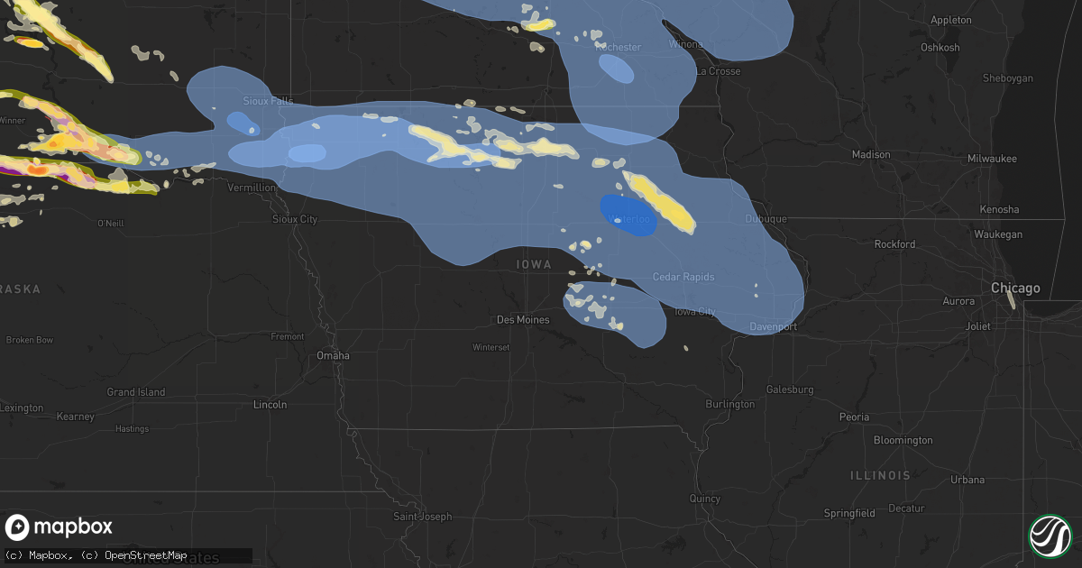
Hail Map in Iowa on July 28, 2025
Get this storm
July 28 map
$229
one time, instant access
Download today. No call, no setup
Keep the $229
Bought the map and want the full workflow? Apply the entire $229 to a subscription within 7 days. None of it is wasted.
Every map, not just this one
This buys you this map. Subscription and you get every map we run, in the markets you choose from a few cities to whole states to nationwide. Plus real-time alerts the moment a storm fires.
Contact data
Name, contact info, occupancy, even credit band for addresses in the footprint. You go from where it hit to who to call.
Become the source they trust
Unlimited branding weather history reports on demand. You already have the documented answer ready for the property owner, and you are the one who showed up with it.
Property data and RoofTrace estimates
Pull up any address you have got, its value and the exact code rules for that jurisdiction, straight from One Click Code. Then RoofTrace estimates the squares, pitch, and roof value, priced the way you price.
Storm reports in Iowa
Iowa
| Date | Description |
|---|---|
| 07/28/20253:45 AM CDT | Time estimated by radar. Minor tree damage was also noted nearby. |
| 07/28/20253:34 AM CDT | A local report indicates 60 MPH wind near Davenport |
| 07/28/20253:34 AM CDT | A local report indicates 60 MPH wind near Davenport |
| 07/28/20253:30 AM CDT | Many small to medium tree branches down. |
| 07/28/20253:29 AM CDT | Davenport municipal airport asos. |
| 07/28/20253:09 AM CDT | Persisting for the past 5 to 10 minutes. |
| 07/28/20253:08 AM CDT | A local report indicates 71 MPH wind near Wyoming |
| 07/28/20253:08 AM CDT | Pine tree snapped across roadway and flagpole broken. |
| 07/28/20253:00 AM CDT | Large tree branch split from a pear tree. Branch seems to be at least 6 inches in diameter. |
| 07/28/20252:41 AM CDT | Asos. |
| 07/28/20252:41 AM CDT | Pws. |
| 07/28/20252:37 AM CDT | Photos of tree damage around lake delhi. |
| 07/28/20252:35 AM CDT | Mesonet station rcri4 anamosa. |
| 07/28/20252:32 AM CDT | Trees and power lines down. |
| 07/28/20252:30 AM CDT | Photo relayed of large tree branch broken off. Time estimated by radar. |
| 07/28/20252:30 AM CDT | A local report indicates 60 MPH wind near Lisbon |
| 07/28/20252:30 AM CDT | Iadot rwis. |
| 07/28/20252:28 AM CDT | Personal weather station. |
| 07/28/20252:26 AM CDT | From pws. |
| 07/28/20252:24 AM CDT | Delayed report of tree branches down. Time estimated by radar. |
| 07/28/20252:13 AM CDT | Measured by personal weather station. |
| 07/28/20252:05 AM CDT | Large tree uprooted in manchester... Which fell on a fence. Time and location estimated. |
| 07/28/20252:01 AM CDT | Pws. |
| 07/28/20252:00 AM CDT | Mesonet station ew8796 independence. |
| 07/28/20251:54 AM CDT | Photo of 14 inch diameter oak tree snapped that narrowly missed falling on a house and garage. Photo relayed via social media. Time estimated by radar. |
| 07/28/20251:50 AM CDT | Large tree down. Many 1-3 inch diameter branches down. |
| 07/28/20251:50 AM CDT | Large trees uprooted. |
| 07/28/20251:48 AM CDT | Trees down. |
| 07/28/20251:48 AM CDT | Tree down in town. |
| 07/28/20251:46 AM CDT | Two 10 inch diameter trees downed. Time estimated. |
| 07/28/20251:44 AM CDT | Trees down in town. |
| 07/28/20251:41 AM CDT | Duration of at least 5 minutes. |
| 07/28/20251:41 AM CDT | Report of four trees 8 to 12 inches in diameter snapped. |
| 07/28/20251:40 AM CDT | Trees leaning 15-20 degrees from vertical. |
| 07/28/20251:40 AM CDT | Broken tree branches estimated 4 inches in diameter. Another tree uprooted. Time estimated by radar. |
| 07/28/20251:38 AM CDT | A few large tree limbs down around town. Time estimated from radar. |
| 07/28/20251:35 AM CDT | Awos station kolz oelwein municipal airport. |
| 07/28/20251:26 AM CDT | Pws gust to 58. |
| 07/28/20251:19 AM CDT | Gust to 78 mph at asos. |
| 07/28/20251:15 AM CDT | Several reports across waterloo of trees on utility lines and transformers. Power is out in various locations around waterloo. Time estimated by radar. |
| 07/28/20251:10 AM CDT | Pws gust. |
| 07/28/202512:49 AM CDT | Several tree branches down blocking roads in town. Time estimated by radar. |
| 07/28/202512:49 AM CDT | Personal weather station. |
| 07/28/202512:11 AM CDT | Pines downed. Picture. Radar time estimated. |
| 07/28/202512:05 AM CDT | Large grain bins destroyed in ventura. Delayed report... Time estimated from radar. Relayed via social media. |
| 07/28/202512:05 AM CDT | Em reported trees down in city of ventura and power out for part of clear lake. |
| 07/28/202512:05 AM CDT | Personal weather station. |
| 07/28/202512:05 AM CDT | Pws recorded gust. |
| 07/28/202512:00 AM CDT | Em relayed trees down in garner... Some roads blocked. |
| 07/28/202512:00 AM CDT | A local report indicates 60 MPH wind near Cresco |
| 07/27/202511:48 PM CDT | Pws measurement. |
| 07/27/202511:29 PM CDT | 75 mph wind gust reported by algona police. |
| 07/27/202511:28 PM CDT | Personal weather station. |
| 07/27/202511:19 PM CDT | Near hobarton. |
| 07/27/202511:17 PM CDT | On the east side of town... An enclosed trailer was flipped on its side by thunderstorm wind gusts. |
| 07/27/202511:16 PM CDT | Updated the peak wind gust previous reported. |
| 07/27/202511:14 PM CDT | Numerous tree branches broken... Ranging from 6 to 18 inches in diameter. Some fell on houses. Many streets are blocked. |
| 07/27/202511:14 PM CDT | Personal weather station. |
| 07/27/202511:13 PM CDT | Measured by personal weather station. |
| 07/27/202511:00 PM CDT | Delayed report from personal weather station. |
| 07/27/202510:52 PM CDT | Personal weather station. |
| 07/27/202510:42 PM CDT | Asos station kspw spencer municipal airport. |
| 07/27/202510:40 PM CDT | Social media report of building damage at the lumber yard in alton. Estimated winds of 80 kts. Timing and winds estimated by radar. |
| 07/27/202510:39 PM CDT | Asos station kspw spencer municipal airport. |
| 07/27/202510:37 PM CDT | Personal weather station |
| 07/27/202510:30 PM CDT | Awos station kslb storm |
| 07/27/202510:30 PM CDT | Awos station kslb storm lake airport. |
| 07/27/202510:25 PM CDT | Trees uprooted in town. Report via mping. |
| 07/27/202510:24 PM CDT | A personal weather station |
| 07/27/202510:16 PM CDT | Many large branches across town knocked down by thunderstorm wind gusts. A camper was flipped upside down on the east side of town. |
| 07/27/202510:08 PM CDT | Highway 59 across the entire town is closed due to so many trees knocked down onto the road by thunderstorm wind gusts. |
| 07/27/202510:02 PM CDT | Large trees snapped and uprooted. |
| 07/27/202510:00 PM CDT | Large trees down on farmstead. |
| 07/27/20259:52 PM CDT | Personal weather station. |
| 07/27/20259:50 PM CDT | Large tree blown down into house and two trees blown onto garage. |
| 07/27/20259:50 PM CDT | Social media report with pictures of damage done to and rv business in sheldon. Winds approximately 90 kts. Timing and wind speeds estimated by radar. |
| 07/27/20259:41 PM CDT | Personal weather station. |
| 07/27/20259:39 PM CDT | Personal weather station. |
| 07/27/20259:34 PM CDT | Trees knocked down by thunderstorm wind gusts. |
| 07/27/20259:34 PM CDT | Personal weather station. |
| 07/27/20259:32 PM CDT | Social media picture of large limb snapped from a tree. |
| 07/27/20259:30 PM CDT | Spotter reported a 2-3 foot in diameter live tree branch down. Time estimated by radar... With an estimated wind speed of 86 kts. |
| 07/27/20259:30 PM CDT | Awos station ksxk 1 ne maurice. |
| 07/27/20259:30 PM CDT | Personal weather station. |
| 07/27/20259:26 PM CDT | Trees knocked down by thunderstorm wind gusts. |
| 07/27/20259:22 PM CDT | Em reports a tree with a roughly 5 foot diameter knocked down. Tree appears at least partially rotted from photos. |
| 07/27/20259:10 PM CDT | Trees knocked down by thunderstorm wind gusts. |
All States Impacted by Hail Map on July 28, 2025
Cities Impacted by Hail Map on July 28, 2025
- Beach, ND
- Medora, ND
- Fairfield, ND
- Sentinel Butte, ND
- Belfield, ND
- Manning, ND
- Dickinson, ND
- Killdeer, ND
- Gladstone, ND
- Amidon, ND
- Taylor, ND
- Richardton, ND
- Hebron, ND
- Glen Ullin, ND
- Ismay, MT
- Fallon, MT
- Miles City, MT
- Regent, ND
- Elgin, ND
- Almont, ND
- Mott, ND
- Carson, ND
- Plevna, MT
- New Salem, ND
- Flasher, ND
- Solen, ND
- Mandan, ND
- Saint Anthony, ND
- Hazelton, ND
- Linton, ND
- Moffit, ND
- Bismarck, ND
- Braddock, ND
- Napoleon, ND
- Steele, ND
- Dawson, ND
- Kintyre, ND
- Tappen, ND
- Streeter, ND
- Chicago, IL
- Edgefield, SC
- Modoc, SC
- Romulus, MI
- Gibson, GA
- Louisville, GA
- Saint Petersburg, FL
- Augusta, MT
- Wrens, GA
- Ideal, SD
- Clancy, MT
- Tuthill, SD
- Saint Francis, SD
- Stanford, MT
- Pierre, SD
- Witten, SD
- East Helena, MT
- Winston, MT
- Moccasin, MT
- Hamill, SD
- Selby, SD
- Onida, SD
- Eagle Butte, SD
- Agar, SD
- Parrish, FL
- Palmetto, FL
- Ellenton, FL
- Council, NC
- Bolton, NC
- Lake Waccamaw, NC
- Blunt, SD
- Akaska, SD
- Java, SD
- Bowdle, SD
- Crumpler, NC
- Harrold, SD
- Gregory, SD
- Winner, SD
- Burke, SD
- White Sulphur Springs, MT
- Hoven, SD
- Carrizozo, NM
- Hosmer, SD
- Orlando, FL
- Windermere, FL
- Oakes, ND
- Frederick, SD
- Hecla, SD
- Dexter, GA
- Rentz, GA
- Dublin, GA
- Mission, SD
- Roscoe, SD
- Cascade, MT
- Helena, MT
- Valentine, NE
- Holabird, SD
- Moore, MT
- Lewistown, MT
- Cogswell, ND
- Highmore, SD
- Tawas City, MI
- Turner, MI
- National City, MI
- Whittemore, MI
- Leola, SD
- Ipswich, SD
- Great Falls, MT
- Stockett, MT
- Sun River, MT
- Hobson, MT
- Platte, SD
- Stephan, SD
- Fort Thompson, SD
- Houghton, SD
- Havana, ND
- Forman, ND
- Rutland, ND
- Westport, SD
- Au Gres, MI
- Claremont, SD
- Britton, SD
- Amherst, SD
- Lidgerwood, ND
- Cayuga, ND
- Veblen, SD
- Claire City, SD
- Hankinson, ND
- Wyndmere, ND
- Mantador, ND
- Wahpeton, ND
- Fairmount, ND
- Waynesboro, TN
- Monarch, MT
- Belt, MT
- Lithia, FL
- Aberdeen, SD
- Crookston, NE
- Wood Lake, NE
- Hyannis, NE
- Whitman, NE
- Coffee Creek, MT
- Clifton, TN
- Cresbard, SD
- Florence, AL
- Faulkton, SD
- Columbia, SD
- Springview, NE
- Gann Valley, SD
- Saint Matthews, SC
- Swansea, SC
- Ree Heights, SD
- Ashland, OH
- Polk, OH
- West Salem, OH
- Memphis, IN
- Henryville, IN
- Raynesford, MT
- Buffalo, MT
- Colome, SD
- Herrick, SD
- Saint Charles, SD
- Mansfield, SD
- Denton, MT
- North, SC
- McRae Helena, GA
- New Effington, SD
- Dallas, SD
- Langford, SD
- Riverview, FL
- Charlestown, IN
- Northville, SD
- Haines, OR
- Fairfax, SD
- Geddes, SD
- Bonesteel, SD
- Kimball, SD
- Geraldine, MT
- Mellette, SD
- Rosholt, SD
- Lumber City, GA
- Wooster, OH
- Geyser, MT
- Eden, SD
- Lake City, SD
- Roslyn, SD
- Alamo, GA
- Brentford, SD
- Ashton, SD
- Forest Grove, MT
- Sisseton, SD
- Grenville, SD
- Judith Gap, MT
- Wheaton, MN
- Tintah, MN
- Campbell, MN
- Elbow Lake, MN
- Norcross, MN
- Herman, MN
- Marysville, MT
- Washington, IN
- Muscle Shoals, AL
- Thonotosassa, FL
- Waubay, SD
- Webster, SD
- Mills, NE
- White Lake, SD
- Lake Andes, SD
- Lavina, MT
- Wessington Springs, SD
- Peever, SD
- Imnaha, OR
- Lower Brule, SD
- Pinconning, MI
- Linwood, MI
- Conde, SD
- Zephyrhills, FL
- Vincennes, IN
- Turton, SD
- Summit, SD
- Wilmot, SD
- Ortley, SD
- Marvin, SD
- South Shore, SD
- Corona, SD
- Twin Brooks, SD
- Ortonville, MN
- Clinton, MN
- Milbank, SD
- Ryegate, MT
- Big Sandy, MT
- Highwood, MT
- Dumont, MN
- Deer Lodge, MT
- Garrison, MT
- Pickstown, SD
- Woonsocket, SD
- Grass Range, MT
- Kennebec, SD
- Chamberlain, SD
- Wagner, SD
- Donnelly, MN
- Barrett, MN
- Depauw, IN
- Naper, NE
- Kawkawlin, MI
- Corydon, IN
- Ramsey, IN
- Roundup, MT
- Atkinson, NE
- Butte, NE
- Stuart, NE
- Chokio, MN
- Big Stone City, SD
- Graceville, MN
- Morris, MN
- Alberta, MN
- Cyrus, MN
- Correll, MN
- Holloway, MN
- Madison, MN
- Marietta, MN
- Bellingham, MN
- Odessa, MN
- Hancock, MN
- Appleton, MN
- Carlos, MN
- Alexandria, MN
- Nelson, MN
- Parkers Prairie, MN
- Long Prairie, MN
- Browerville, MN
- Clarissa, MN
- Eagle Bend, MN
- Miltona, MN
- Osakis, MN
- Grey Eagle, MN
- Sauk Centre, MN
- Cushing, MN
- Randall, MN
- Swanville, MN
- Burtrum, MN
- Little Falls, MN
- Freeport, MN
- Melrose, MN
- Flensburg, MN
- Bowlus, MN
- Shawmut, MT
- Wheatland, IN
- Hoffman, MN
- Kensington, MN
- Farwell, MN
- Two Dot, MT
- Letcher, SD
- Artesian, SD
- Johnstown, NE
- Montgomery, IN
- Starbuck, MN
- Villard, MN
- Lowry, MN
- Danvers, MN
- Glenwood, MN
- Benson, MN
- Clontarf, MN
- Milan, MN
- Model, CO
- Ainsworth, NE
- Tuscumbia, AL
- Armour, SD
- Lynch, NE
- Spencer, NE
- Bristow, NE
- Delmont, SD
- Tripp, SD
- Scotland, SD
- Avon, SD
- Dante, SD
- Tyndall, SD
- Olivet, SD
- Kaylor, SD
- Lesterville, SD
- Tabor, SD
- Oneill, NE
- Long Pine, NE
- Eastover, SC
- Springfield, GA
- Bend, OR
- Harlowton, MT
- Fulton, SD
- Mitchell, SD
- Richland, IN
- Verdigre, NE
- Niobrara, NE
- Menno, SD
- Freeman, SD
- Yankton, SD
- Viborg, SD
- Mission Hill, SD
- Irene, SD
- Utica, SD
- Holdingford, MN
- Royalton, MN
- Upsala, MN
- Presho, SD
- Chrisney, IN
- Albany, MN
- Rice, MN
- Avon, MN
- Saint Joseph, MN
- Saint Stephen, MN
- Rockport, IN
- Bassett, NE
- Rincon, GA
- Kerkhoven, MN
- Atwater, MN
- Murdock, MN
- Richmond, MN
- Spicer, MN
- Willmar, MN
- Dawson, MN
- Montevideo, MN
- Elrosa, MN
- New London, MN
- Watson, MN
- Pennock, MN
- Eden Valley, MN
- Brooten, MN
- Belgrade, MN
- Roscoe, MN
- Sunburg, MN
- Paynesville, MN
- Granite Falls, MN
- Maynard, MN
- Clara City, MN
- Sacred Heart, MN
- Kandiyohi, MN
- Clarkfield, MN
- Boyd, MN
- Grove City, MN
- Blomkest, MN
- Prinsburg, MN
- Renville, MN
- Wood Lake, MN
- Hanley Falls, MN
- Raymond, MN
- Echo, MN
- Ellabell, GA
- Dorchester, SC
- Harleyville, SC
- Newport, NE
- Avon, MT
- Eastview, KY
- Guyton, GA
- Ridgeland, SC
- Hardeeville, SC
- Petersburg, IN
- Owensboro, KY
- Princeton, MN
- Harlem, MT
- Ridgeville, SC
- Utica, KY
- Marion, SD
- Canistota, SD
- Crooks, SD
- Baltic, SD
- Hartford, SD
- Monroe, SD
- Montrose, SD
- Hurley, SD
- Colton, SD
- Lyons, SD
- Parker, SD
- Chancellor, SD
- Humboldt, SD
- Volin, SD
- Bridgewater, SD
- Emery, SD
- Alexandria, SD
- Winfred, SD
- Spencer, SD
- Salem, SD
- Tea, SD
- Sioux Falls, SD
- Renner, SD
- Lennox, SD
- Davis, SD
- Harrisburg, SD
- Centerville, SD
- Brandon, SD
- Worthing, SD
- Larchwood, IA
- Canton, SD
- Burbank, SD
- Alcester, SD
- Vermillion, SD
- Elk Point, SD
- Wakonda, SD
- Beresford, SD
- Hudson, SD
- Cokato, MN
- Litchfield, MN
- Morton, MN
- Bird Island, MN
- Fairfax, MN
- Silver Lake, MN
- Hector, MN
- Belview, MN
- Olivia, MN
- Glencoe, MN
- Danube, MN
- Hutchinson, MN
- Lake Lillian, MN
- Buffalo Lake, MN
- Winthrop, MN
- New Auburn, MN
- Cosmos, MN
- Kimball, MN
- Brownton, MN
- Stewart, MN
- Darwin, MN
- Franklin, MN
- Gaylord, MN
- Gibbon, MN
- Watkins, MN
- Redwood Falls, MN
- Dassel, MN
- Morgan, MN
- Sleepy Eye, MN
- Seaforth, MN
- Wabasso, MN
- Vesta, MN
- Springfield, SD
- Cambridge, MN
- Riverside, OR
- Gary, SD
- Clyo, GA
- Crofton, NE
- Tillman, SC
- Hamburg, MN
- Arlington, MN
- Winsted, MN
- Plato, MN
- Lester Prairie, MN
- Green Isle, MN
- Norwood Young America, MN
- South Haven, MN
- Howard Lake, MN
- Waverly, MN
- Mayer, MN
- New Germany, MN
- Young America, MN
- Hills, MN
- Lester, IA
- Rock Rapids, IA
- Steen, MN
- Valley Springs, SD
- Inwood, IA
- Alvord, IA
- Westfield, IA
- Merrill, IA
- Hawarden, IA
- Chatsworth, IA
- Fairview, SD
- Doon, IA
- Hull, IA
- Le Mars, IA
- Sioux Center, IA
- Ireton, IA
- Akron, IA
- Rock Valley, IA
- Ingomar, MT
- Musselshell, MT
- Melstone, MT
- Custer, MT
- Forsyth, MT
- Worden, MT
- Hysham, MT
- Winnett, MT
- Orange City, IA
- Boyden, IA
- Maurice, IA
- Alton, IA
- George, IA
- Granville, IA
- Remsen, IA
- Hospers, IA
- Brunsville, IA
- Sheldon, IA
- Sparks, NV
- Annandale, MN
- Virginia City, NV
- Hamel, MN
- Buffalo, MN
- Rockford, MN
- Delano, MN
- Montrose, MN
- Maple Lake, MN
- Loretto, MN
- Elk River, MN
- Becker, MN
- Maple Grove, MN
- Monticello, MN
- Hanover, MN
- Saint Michael, MN
- Saint Cloud, MN
- Osseo, MN
- Albertville, MN
- Zimmerman, MN
- Clearwater, MN
- Big Lake, MN
- Rogers, MN
- Anoka, MN
- Waite Park, MN
- Clear Lake, MN
- Cold Spring, MN
- Dayton, MN
- Sartell, MN
- Sauk Rapids, MN
- Foley, MN
- Saint Francis, MN
- Oak Park, MN
- Milaca, MN
- Pierz, MN
- Foreston, MN
- Center City, MN
- Stacy, MN
- Isanti, MN
- Lindstrom, MN
- Chisago City, MN
- North Branch, MN
- Cedar, MN
- Dalbo, MN
- Stanchfield, MN
- Pease, MN
- Bethel, MN
- New Richmond, WI
- Scandia, MN
- Andover, MN
- Star Prairie, WI
- Forest Lake, MN
- Shafer, MN
- Osceola, WI
- Somerset, WI
- Marine On Saint Croix, MN
- Wyoming, MN
- Hammond, WI
- Hugo, MN
- Baldwin, WI
- Stillwater, MN
- Minneapolis, MN
- Saint Paul, MN
- Houlton, WI
- Bayport, MN
- Hudson, WI
- Circle Pines, MN
- Roberts, WI
- Willernie, MN
- Champlin, MN
- Waconia, MN
- Maple Plain, MN
- Hopkins, MN
- Watertown, MN
- Lakeland, MN
- Minnetonka, MN
- Long Lake, MN
- Wayzata, MN
- Lake Elmo, MN
- Saint Bonifacius, MN
- Excelsior, MN
- Mound, MN
- Spring Park, MN
- Mendota, MN
- Le Center, MN
- Saint Paul Park, MN
- Victoria, MN
- Henderson, MN
- Newport, MN
- Belle Plaine, MN
- Elko New Market, MN
- Burnsville, MN
- Prior Lake, MN
- South Saint Paul, MN
- Le Sueur, MN
- Savage, MN
- Carver, MN
- Cologne, MN
- Cleveland, MN
- Rosemount, MN
- Webster, MN
- Shakopee, MN
- New Prague, MN
- Farmington, MN
- Hastings, MN
- Cottage Grove, MN
- Afton, MN
- Lakeville, MN
- Chaska, MN
- Inver Grove Heights, MN
- Jordan, MN
- Eden Prairie, MN
- River Falls, WI
- Chanhassen, MN
- Montgomery, MN
- Lonsdale, MN
- Madison Lake, MN
- Nicollet, MN
- Kasota, MN
- Saint Peter, MN
- Lafayette, MN
- Mankato, MN
- Courtland, MN
- New Ulm, MN
- Springfield, MN
- Woodville, WI
- Northfield, MN
- Hampton, MN
- Vermillion, MN
- Elysian, MN
- Prescott, WI
- Kilkenny, MN
- Waterville, MN
- Sanborn, MN
- Rosebud, MT
- Molt, MT
- Billings, MT
- Shepherd, MT
- Acton, MT
- Granada, MN
- Fairmont, MN
- Park City, MT
- Eagle Lake, MN
- Absarokee, MT
- Janesville, MN
- Laurel, MT
- Wilson, WI
- Glenwood City, WI
- Beldenville, WI
- Randolph, MN
- Dundas, MN
- Knapp, WI
- Menomonie, WI
- Ellsworth, WI
- Hager City, WI
- Cannon Falls, MN
- Faribault, MN
- Welch, MN
- Spring Valley, WI
- Amery, WI
- Elmwood, WI
- Deer Park, WI
- Downing, WI
- Boyceville, WI
- Worthington, MN
- Bigelow, MN
- Little Rock, IA
- Sanborn, IA
- Matlock, IA
- Lake Park, IA
- Harris, IA
- Round Lake, MN
- Ashton, IA
- Primghar, IA
- Sibley, IA
- Spirit Lake, IA
- Melvin, IA
- Archer, IA
- Rushmore, MN
- Hartley, IA
- Ocheyedan, IA
- Lakefield, MN
- Adrian, MN
- Estherville, IA
- Jackson, MN
- Alpha, MN
- Okoboji, IA
- Dunnell, MN
- Milford, IA
- Everly, IA
- Kenyon, MN
- Dennison, MN
- Goodhue, MN
- Maiden Rock, WI
- Red Wing, MN
- Zumbrota, MN
- Owatonna, MN
- Bay City, WI
- Nerstrand, MN
- Morristown, MN
- Waseca, MN
- Warsaw, MN
- Medford, MN
- Spencer, IA
- Meriden, IA
- Truesdale, IA
- Superior, IA
- Fostoria, IA
- Sutherland, IA
- Calumet, IA
- Storm Lake, IA
- Early, IA
- Royal, IA
- Aurelia, IA
- Arnolds Park, IA
- Linn Grove, IA
- Albert City, IA
- Gillett Grove, IA
- Cherokee, IA
- Schaller, IA
- Greenville, IA
- Ruthven, IA
- Rembrandt, IA
- Peterson, IA
- Webb, IA
- Cleghorn, IA
- Nemaha, IA
- Terril, IA
- Galva, IA
- Marathon, IA
- Dickens, IA
- Larrabee, IA
- Paullina, IA
- Sioux Rapids, IA
- Alta, IA
- Marcus, IA
- Kingsley, IA
- Holstein, IA
- Washta, IA
- Quimby, IA
- Pierson, IA
- Oyens, IA
- Blue Earth, MN
- Columbus, MT
- Reed Point, MT
- Elmore, MN
- Huntley, MT
- Elk Mound, WI
- Pepin, WI
- Durand, WI
- West Concord, MN
- Mondovi, WI
- Plum City, WI
- Stockholm, WI
- Wanamingo, MN
- Eau Claire, WI
- Lake City, MN
- Frontenac, MN
- Eau Galle, WI
- Arkansaw, WI
- Nelson, WI
- Waltham, MN
- Elgin, MN
- Claremont, MN
- Mantorville, MN
- Blooming Prairie, MN
- Millville, MN
- Hayfield, MN
- Mazeppa, MN
- Oronoco, MN
- Austin, MN
- Zumbro Falls, MN
- Rochester, MN
- Kasson, MN
- Reads Landing, MN
- Byron, MN
- Kellogg, MN
- Wabasha, MN
- Pine Island, MN
- Dodge Center, MN
- Ellendale, MN
- Ayrshire, IA
- Curlew, IA
- Mallard, IA
- Emmetsburg, IA
- Cylinder, IA
- Ballantine, MT
- Big Timber, MT
- Graettinger, IA
- Roberts, MT
- Wallingford, IA
- Joliet, MT
- Rake, IA
- Buffalo Center, IA
- Algona, IA
- Fenton, IA
- Ringsted, IA
- Whittemore, IA
- West Bend, IA
- Swea City, IA
- Ledyard, IA
- Lu Verne, IA
- Colfax, WI
- New Auburn, WI
- Ridgeland, WI
- Wheeler, WI
- Bloomer, WI
- Dresser, WI
- Clear Lake, WI
- Chetek, WI
- Dallas, WI
- Clayton, WI
- Prairie Farm, WI
- Rome, GA
- Sargeant, MN
- Spring Valley, MN
- Dexter, MN
- Chatfield, MN
- Racine, MN
- Stewartville, MN
- Grand Meadow, MN
- Fall Creek, WI
- Augusta, WI
- Thorp, WI
- Stanley, WI
- Boyd, WI
- Cadott, WI
- Chippewa Falls, WI
- Jim Falls, WI
- Cochrane, WI
- Whitehall, WI
- Saint Charles, MN
- Arcadia, WI
- Greenwood, WI
- Willard, WI
- Alma, WI
- Strum, WI
- Osseo, WI
- Altura, MN
- Fairchild, WI
- Brownsdale, MN
- Eyota, MN
- Eleva, WI
- Plainview, MN
- Independence, WI
- Altoona, WI
- Wykoff, MN
- Elkton, MN
- Minnesota City, MN
- Ostrander, MN
- Dover, MN
- Fountain City, WI
- Winona, MN
- Humbird, WI
- Rollingstone, MN
- Lewiston, MN
- Blair, WI
- Utica, MN
- Hixton, WI
- Alma Center, WI
- Fountain, MN
- Dodge, WI
- Lansing, MN
- Varina, IA
- Armstrong, IA
- Burt, IA
- Wesley, IA
- Ottosen, IA
- Forest City, IA
- Thompson, IA
- Leland, IA
- Woden, IA
- Ceylon, MN
- Newell, IA
- Havelock, IA
- Fonda, IA
- Plover, IA
- Laurens, IA
- Lakota, IA
- Titonka, IA
- Dolliver, IA
- Rolfe, IA
- Pocahontas, IA
- Britt, IA
- Lone Rock, IA
- Bancroft, IA
- Scranton, IA
- Rockwell City, IA
- Goldfield, IA
- Renwick, IA
- Crystal Lake, IA
- Moorland, IA
- Fort Dodge, IA
- Dakota City, IA
- Jefferson, IA
- Sac City, IA
- Lake City, IA
- Bode, IA
- Barnum, IA
- Clare, IA
- Paton, IA
- Rutland, IA
- Pomeroy, IA
- Manson, IA
- Garner, IA
- Callender, IA
- Auburn, IA
- Gowrie, IA
- Lohrville, IA
- Thor, IA
- Palmer, IA
- Livermore, IA
- Knierim, IA
- Badger, IA
- Churdan, IA
- Lytton, IA
- Jolley, IA
- Hardy, IA
- Farnhamville, IA
- Corwith, IA
- Somers, IA
- Gilmore City, IA
- Bradgate, IA
- Humboldt, IA
- Kanawha, IA
- Lanesboro, IA
- Glidden, IA
- Brockway, MT
- Terry, MT
- Circle, MT
- Lindsay, MT
- Bloomfield, MT
- Glendive, MT
- Bonanza, OR
- Edgar, MT
- Vincent, IA
- Joice, IA
- Lake Mills, IA
- Eagle Grove, IA
- Otho, IA
- Peterson, MN
- Preston, MN
- Lanesboro, MN
- Rushford, MN
- Galesville, WI
- Trempealeau, WI
- Taylor, WI
- Ettrick, WI
- Dana, IA
- Harcourt, IA
- Woolstock, IA
- Fertile, IA
- Webster City, IA
- Duncombe, IA
- Boxholm, IA
- Belmond, IA
- Lehigh, IA
- Clarion, IA
- Pilot Mound, IA
- Goodell, IA
- Burnside, IA
- Ogden, IA
- Dayton, IA
- Klemme, IA
- Stratford, IA
- Scarville, IA
- Neillsville, WI
- Merrillan, WI
- Black River Falls, WI
- Holmen, WI
- Melrose, WI
- Houston, MN
- Dakota, MN
- Blairsburg, IA
- Dows, IA
- Meservey, IA
- Kensett, IA
- Rockwell, IA
- Plymouth, IA
- Rowan, IA
- Alexander, IA
- Mason City, IA
- Swaledale, IA
- Grafton, IA
- Manly, IA
- Thornton, IA
- Ventura, IA
- Galt, IA
- Boone, IA
- Hanlontown, IA
- Clear Lake, IA
- Rose Creek, MN
- Little Cedar, IA
- Saint Ansgar, IA
- Harmony, MN
- Riceville, IA
- Chester, IA
- Lyle, MN
- Taopi, MN
- Le Roy, MN
- Osage, IA
- Lime Springs, IA
- Adams, MN
- Stacyville, IA
- McIntire, IA
- Albert Lea, MN
- Jewell, IA
- Kamrar, IA
- Williams, IA
- Latimer, IA
- Sheffield, IA
- Stanhope, IA
- Pompeys Pillar, MT
- Hardin, MT
- Rockford, IA
- Nora Springs, IA
- Hampton, IA
- Warrens, WI
- Sparta, WI
- Pittsville, WI
- Mindoro, WI
- Tomah, WI
- Bangor, WI
- Granton, WI
- Norwalk, WI
- West Salem, WI
- Rockland, WI
- Onalaska, WI
- Ellsworth, IA
- Marble Rock, IA
- Floyd, IA
- Popejoy, IA
- Greene, IA
- Charles City, IA
- Alden, IA
- Elma, IA
- Rudd, IA
- Iowa Falls, IA
- Rock Falls, IA
- Aredale, IA
- Coulter, IA
- Orchard, IA
- Chapin, IA
- Dougherty, IA
- Canton, MN
- Decorah, IA
- Mabel, MN
- Spring Grove, MN
- Caledonia, MN
- Cresco, IA
- Alta Vista, IA
- Bristow, IA
- Bradford, IA
- Geneva, IA
- Colwell, IA
- Dumont, IA
- Story City, IA
- Allison, IA
- Radcliffe, IA
- New Providence, IA
- Ionia, IA
- Eldora, IA
- Steamboat Rock, IA
- Nashua, IA
- Clarksville, IA
- Ackley, IA
- Aplington, IA
- Hubbard, IA
- Austinville, IA
- Garden City, IA
- Kesley, IA
- Ridgeway, IA
- Waucoma, IA
- Calmar, IA
- Fort Atkinson, IA
- Protivin, IA
- Lawler, IA
- New Hampton, IA
- Randall, IA
- Waverly, IA
- Plainfield, IA
- Fredericksburg, IA
- Frederika, IA
- Sumner, IA
- Tripoli, IA
- Union, IA
- Conrad, IA
- Cedar Falls, IA
- Beaman, IA
- Parkersburg, IA
- Shell Rock, IA
- Wellsburg, IA
- Spillville, IA
- Hawkeye, IA
- Liscomb, IA
- Grundy Center, IA
- Denver, IA
- Reinbeck, IA
- Janesville, IA
- Dunkerton, IA
- Lincoln, IA
- Traer, IA
- Hudson, IA
- Dike, IA
- Montour, IA
- New Hartford, IA
- Waterloo, IA
- Gladbrook, IA
- Albion, IA
- Whitten, IA
- Morrison, IA
- Readlyn, IA
- Garwin, IA
- Stout, IA
- Marshalltown, IA
- Toledo, IA
- Holland, IA
- Clemons, IA
- Fairbank, IA
- Evansdale, IA
- Gilbertville, IA
- Dewar, IA
- Independence, IA
- Jesup, IA
- Raymond, IA
- Brandon, IA
- La Porte City, IA
- West Union, IA
- Randalia, IA
- Dysart, IA
- Maynard, IA
- Buckingham, IA
- Hazleton, IA
- Clutier, IA
- Saint Lucas, IA
- Oran, IA
- Oelwein, IA
- Westgate, IA
- Melbourne, IA
- State Center, IA
- Baxter, IA
- Bighorn, MT
- Arlington, IA
- Fayette, IA
- Stanley, IA
- Elgin, IA
- Wadena, IA
- Ossian, IA
- Clermont, IA
- Elberon, IA
- Mount Auburn, IA
- Garrison, IA
- Chelsea, IA
- Vining, IA
- Vinton, IA
- Tama, IA
- Keystone, IA
- Aurora, IA
- Sully, IA
- Kellogg, IA
- Newton, IA
- Winthrop, IA
- Haverhill, IA
- Laurel, IA
- Grinnell, IA
- Masonville, IA
- Lamont, IA
- Gilman, IA
- Belle Plaine, IA
- Hartwick, IA
- Brooklyn, IA
- Malcom, IA
- Marengo, IA
- Barnes City, IA
- Killduff, IA
- Searsboro, IA
- Montezuma, IA
- Deep River, IA
- Guernsey, IA
- New Sharon, IA
- Victor, IA
- Lynnville, IA
- Reasnor, IA
- Ladora, IA
- Volga, IA
- Elkport, IA
- Guttenberg, IA
- Edgewood, IA
- Elkader, IA
- Strawberry Point, IA
- Garnavillo, IA
- Garber, IA
- Manchester, IA
- Rowley, IA
- Dundee, IA
- Delaware, IA
- Ryan, IA
- Cedar Rapids, IA
- Tiffin, IA
- Earlville, IA
- Quasqueton, IA
- Oxford, IA
- Ely, IA
- Alburnett, IA
- North Liberty, IA
- Urbana, IA
- Center Point, IA
- Robins, IA
- Walker, IA
- Coggon, IA
- Central City, IA
- Greeley, IA
- Atkins, IA
- Toddville, IA
- Solon, IA
- Palo, IA
- Swisher, IA
- Hiawatha, IA
- Hopkinton, IA
- Monticello, IA
- Anamosa, IA
- New Vienna, IA
- Delhi, IA
- Iowa City, IA
- Shellsburg, IA
- Marion, IA
- Prairieburg, IA
- Springville, IA
- Coralville, IA
- Colesburg, IA
- Mount Vernon, IA
- Dyersville, IA
- Fairfax, IA
- Amana, IA
- South Amana, IA
- Walford, IA
- Watkins, IA
- Norway, IA
- Middle Amana, IA
- Homestead, IA
- Newhall, IA
- Blairstown, IA
- Van Horne, IA
- Luzerne, IA
- Colstrip, MT
- Decker, MT
- Birney, MT
- North English, IA
- Gibson, IA
- Worthington, IA
- Bernard, IA
- Farley, IA
- Durango, IA
- North Buena Vista, IA
- Epworth, IA
- Cassville, WI
- Lisbon, IA
- Sherrill, IA
- Holy Cross, IA
- Martelle, IA
- Cascade, IA
- Glen Haven, WI
- Dubuque, IA
- Langworthy, IA
- Peosta, IA
- Luxemburg, IA
- Center Junction, IA
- Morley, IA
- Stanwood, IA
- Oxford Junction, IA
- West Branch, IA
- Andrew, IA
- Spragueville, IA
- Onslow, IA
- Lost Nation, IA
- Bellevue, IA
- Tipton, IA
- Donahue, IA
- La Motte, IA
- Wyoming, IA
- Olin, IA
- New Liberty, IA
- Wheatland, IA
- De Witt, IA
- Dixon, IA
- Zwingle, IA
- Monmouth, IA
- Mechanicsville, IA
- Grand Mound, IA
- Bennett, IA
- Maquoketa, IA
- Baldwin, IA
- Clarence, IA
- Lowden, IA
- Stockton, IA
- Calamus, IA
- Delmar, IA
- Atalissa, IA
- Wilton, IA
- West Liberty, IA
- Moscow, IA
- Potosi, WI
- Crow Agency, MT
- Long Grove, IA
- Clinton, IA
- Miles, IA
- Goose Lake, IA
- Charlotte, IA
- Bryant, IA
- Preston, IA
- Welton, IA
- Walcott, IA
- Durant, IA
- Washington, IA
- Mendota, IL
- Cordova, IL
- Elwood, IL
- Deer Grove, IL
- McCausland, IA
- Shorewood, IL
- Hillsdale, IL
- Joliet, IL
- Sublette, IL
- Sheridan, IL
- Monee, IL
- Newark, IL
- Earlville, IL
- Walnut, IL
- Channahon, IL
- Leland, IL
- Princeton, IA
- Ohio, IL
- Tampico, IL
- Prophetstown, IL
- Erie, IL
- Serena, IL
- Eldridge, IA
- La Moille, IL
- Harmon, IL
- Frankfort, IL
- Manhattan, IL
- Minooka, IL
- Albany, IL
- Rock Falls, IL
- Fromberg, MT
- Bettendorf, IA
- Rock Island, IL
- Davenport, IA
- Moline, IL
- Fulton, IL
- Camanche, IA
- Port Byron, IL
- Low Moor, IA
- Hampton, IL
- Rapids City, IL
- Pleasant Valley, IA
- Le Claire, IA
- East Moline, IL
- Milan, IL
- Buffalo, IA
- Blue Grass, IA
- Taylor Ridge, IL
- Montpelier, IA
- Muscatine, IA
- Conroy, IA
- Williamsburg, IA
- Keota, IA
- Harper, IA
- Millersburg, IA
- South English, IA
- What Cheer, IA
- Keswick, IA
- Parnell, IA
- Sigourney, IA
- Webster, IA
- Wellman, IA


