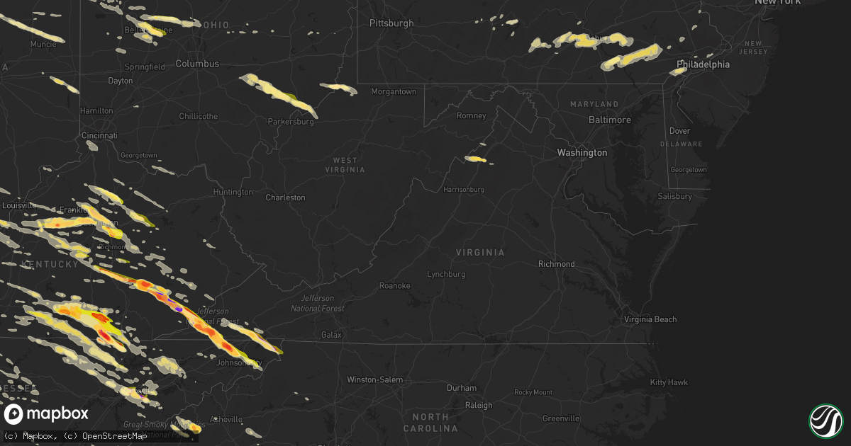
Hail Map in Virginia on July 27, 2014
Get this storm
July 27 map
$229
one time, instant access
Download today. No call, no setup
Keep the $229
Bought the map and want the full workflow? Apply the entire $229 to a subscription within 7 days. None of it is wasted.
Every map, not just this one
This buys you this map. Subscription and you get every map we run, in the markets you choose from a few cities to whole states to nationwide. Plus real-time alerts the moment a storm fires.
Contact data
Name, contact info, occupancy, even credit band for addresses in the footprint. You go from where it hit to who to call.
Become the source they trust
Unlimited branding weather history reports on demand. You already have the documented answer ready for the property owner, and you are the one who showed up with it.
Property data and RoofTrace estimates
Pull up any address you have got, its value and the exact code rules for that jurisdiction, straight from One Click Code. Then RoofTrace estimates the squares, pitch, and roof value, priced the way you price.
Storm reports in Virginia
Virginia
| Date | Description |
|---|---|
| 07/27/20145:35 PM CDT | A local report indicates 1.75 inch wind near 1 NW BRISTOL VA |
| 07/27/20144:12 PM CDT | A local report indicates 2.75 inch wind near DUFFIELD |
| 07/27/20144:12 PM CDT | Several trees down |
| 07/27/20144:10 PM CDT | 2 police cars destroyed by damage from golf ball size or larger hail. Lots of debris on roadways. |
| 07/27/20144:03 PM CDT | A local report indicates 2.00 inch wind near DRYDEN |
| 07/27/20144:00 PM CDT | A local report indicates 2.50 inch wind near PENNINGTON GAP |
| 07/27/20144:00 PM CDT | A local report indicates 1.75 inch wind near DRYDEN |
| 07/27/20143:54 PM CDT | A local report indicates 1.75 inch wind near PENNINGTON GAP |
| 07/26/20148:53 PM CDT | At residence on stout rd. |
| 07/26/20148:50 PM CDT | Golf ball size hail reported in the 3700 block of swover creek road. |
All States Impacted by Hail Map on July 27, 2014
Cities Impacted by Hail Map on July 27, 2014
- La Follette, TN
- Pioneer, TN
- Georgetown, KY
- Lexington, KY
- Walland, TN
- Seymour, TN
- Maryville, TN
- Hereford, TX
- Quemado, NM
- Camden, IN
- Logansport, IN
- Delphi, IN
- Galveston, IN
- Clayton, IN
- Danville, IN
- Coatesville, IN
- Paris, KY
- Sadieville, KY
- Corinth, KY
- Cynthiana, KY
- Warsaw, IN
- Danville, KY
- Harrodsburg, KY
- Lancaster, KY
- Mathias, WV
- Duffield, VA
- Stephentown, NY
- Monroe, TN
- Alpine, TN
- Byrdstown, TN
- Jamestown, TN
- Versailles, KY
- Abingdon, VA
- Luther, MI
- Tustin, MI
- Booneville, KY
- Manistee, MI
- Tawas City, MI
- Pennington Gap, VA
- Dryden, VA
- Troy, WV
- Warbranch, KY
- Mozelle, KY
- Helton, KY
- Chappell, KY
- Midland, MI
- Zanesfield, OH
- Bellefontaine, OH
- Huntsville, OH
- Lewistown, OH
- East Liberty, OH
- Burnside, KY
- Bronston, KY
- Monticello, KY
- Whitley City, KY
- Parkers Lake, KY
- Trementina, NM
- Mesick, MI
- Voorhees, NJ
- Gibbsboro, NJ
- Stratford, NJ
- Clementon, NJ
- Somerdale, NJ
- Nappanee, IN
- Clifford, MI
- Silverwood, MI
- Mayville, MI
- Sedona, AZ
- Kawkawlin, MI
- Auburn, MI
- Bay City, MI
- Waterford, OH
- Mackville, KY
- San Carlos, AZ
- Otisville, MI
- Clio, MI
- Millington, MI
- Proctor, WV
- New Martinsville, WV
- Munith, MI
- Jackson, MI
- Grass Lake, MI
- Richmond, KY
- Winchester, KY
- Young, AZ
- Brodhead, KY
- Kingsley, MI
- Sterling, MI
- Standish, MI
- Lost City, WV
- Montrose, MI
- Birch Run, MI
- Somerset, KY
- Oak Park, MI
- Southfield, MI
- Farmington, MI
- Berkley, MI
- Stanwood, MI
- Big Rapids, MI
- West Mansfield, OH
- Rushsylvania, OH
- Ridgeway, OH
- Richwood, OH
- Mount Victory, OH
- Celina, TN
- Zeeland, MI
- Holland, MI
- Manton, MI
- Bloomfield, KY
- Waddy, KY
- Shelbyville, KY
- Taylorsville, KY
- Mount Eden, KY
- Lawrenceburg, KY
- Mcconnelsville, OH
- Malta, OH
- New Boston, MI
- Belleville, MI
- Bloomsbury, NJ
- Milford, NJ
- Ann Arbor, MI
- Camden, WV
- Rutherfordton, NC
- Columbus, NC
- Quincy, MI
- Reading, MI
- Colchester, VT
- Essex Junction, VT
- Westford, VT
- Milton, VT
- Raton, NM
- Big Creek, KY
- Manchester, KY
- Highland, MI
- Holly, MI
- Columbia City, IN
- Albion, IN
- Churubusco, IN
- Mount Carmel, TN
- Blountville, TN
- Kingsport, TN
- Church Hill, TN
- Johnson City, TN
- Gate City, VA
- South Boardman, MI
- Fife Lake, MI
- Linwood, MI
- Pinconning, MI
- Mill Creek, IN
- Stevensville, MI
- Saint Joseph, MI
- London, KY
- Perryville, KY
- Coxs Creek, KY
- Junction City, KY
- Shepherdsville, KY
- Annville, KY
- Butler, TN
- Piney Flats, TN
- Weber City, VA
- Brooks, KY
- Elizabeth, IN
- Rogersville, TN
- Jonesborough, TN
- Hyden, KY
- Holmes Mill, KY
- Stamping Ground, KY
- Midway, KY
- Waco, KY
- Irvine, KY
- Big Stone Gap, VA
- McKee, KY
- Keokee, VA
- Crab Orchard, KY
- Oneida, KY
- Evarts, KY
- Watauga, TN
- Sextons Creek, KY
- Closplint, KY
- Bledsoe, KY
- Big Laurel, KY
- Sizerock, KY
- Clermont, KY
- Louisville, KY
- Fairfield, KY
- Elizabethton, TN
- East Bernstadt, KY
- Mauckport, IN
- Mount Washington, KY
- Laconia, IN
- Livingston, KY
- Corydon, IN
- Saint Charles, VA
- Ravenna, KY
- Central, IN
- Frankfort, KY
- Totz, KY
- Tyner, KY
- Thousandsticks, KY
- West Point, KY
- Orlando, KY
- Stanford, KY
- Burgin, KY
- Springfield, KY
- Stinnett, KY
- Putney, KY
- Mount Vernon, KY
- Essie, KY
- Willisburg, KY
- Bear Branch, KY
- Blackwater, VA
- Waynesburg, KY
- Lebanon Junction, KY
- Muldraugh, KY
- Brandenburg, KY
- Nicholasville, KY
- Bardstown, KY
- Roan Mountain, TN
- Hampton, TN
- Smithville, TN
- Walling, TN
- Knoxville, TN
- Albion, MI
- Springport, MI
- Belle Center, OH
- Radnor, OH
- Waldo, OH
- Delaware, OH
- La Rue, OH
- Prospect, OH
- Beverly, OH
- Stockport, OH
- Glennie, MI
- Roy, NM
- Oscoda, MI
- Kalamazoo, MI
- Richland, MI
- Plainwell, MI
- Baker, CA
- Commerce Township, MI
- Davisburg, MI
- Waterford, MI
- Pontiac, MI
- Hartland, MI
- Howell, MI
- Milford, MI
- Fenton, MI
- West Bloomfield, MI
- White Lake, MI
- Keego Harbor, MI
- Bloomfield Hills, MI
- Newcomb, TN
- Carlisle, PA
- Plymouth, WI
- Kohler, WI
- Sheboygan Falls, WI
- Sevierville, TN
- Roscommon, MI
- Charlotte, VT
- North Ferrisburgh, VT
- Crooksville, OH
- Franklin, PA
- Thorn Hill, TN
- Washburn, TN
- Newport, MI
- West Liberty, OH
- Oconto, WI
- Santa Fe, NM
- Kalkaska, MI
- Jackson Center, OH
- Russells Point, OH
- Cable, OH
- De Graff, OH
- Lakeview, OH
- Quincy, OH
- Raymond, OH
- Wapakoneta, OH
- Mountain, WI
- Dungannon, VA
- Mountain City, TN
- Bristol, VA
- Nickelsville, VA
- Shady Valley, TN
- Mendota, VA
- Bristol, TN
- Hiltons, VA
- Lebanon, VA
- Brownsville, IN
- Liberty, IN
- Huntertown, IN
- Fort Wayne, IN
- Fowler, CO
- Summer Shade, KY
- Nashville, TN
- Whites Creek, TN
- Cromwell, IN
- Larwill, IN
- North Webster, IN
- Pierceton, IN
- Russell Springs, KY
- Clarington, OH
- Hannibal, OH
- Sardis, OH
- Littleton, WV
- Bainbridge, IN
- Roachdale, IN
- Rochester, IN
- Monterey, IN
- Los Lunas, NM
- Franklin, KY
- Columbia, KY
- Dunnville, KY
- Utica, MI
- Wrightsville, PA
- Red Lion, PA
- Windsor, PA
- Washington Boro, PA
- Columbia, PA
- York, PA
- Deford, MI
- Cass City, MI
- East Jordan, MI
- Whitmore Lake, MI
- Plymouth, MI
- South Lyon, MI
- Ypsilanti, MI
- East Tawas, MI
- Troy, NY
- Watervliet, NY
- Albany, NY
- Wynantskill, NY
- Latham, NY
- Newville, PA
- Rockford, TN
- Lake, MI
- Texline, TX
- Springer, NM
- Frenchburg, KY
- Haslett, MI
- Laingsburg, MI
- Perry, MI
- East Lansing, MI
- Atlanta, MI
- Johannesburg, MI
- Mancelona, MI
- Rapid City, MI
- Jean, NV
- Clarksville, TN
- Guthrie, KY
- Trenton, KY
- Mule Creek, NM
- Strunk, KY
- Pine Knot, KY
- Sparta, TN
- Mount Sterling, KY
- Owingsville, KY
- Carlisle, KY
- Sharpsburg, KY
- Hope, KY
- Means, KY
- Mosquero, NM
- Conchas Dam, NM
- Cubero, NM
- Marion, MI
- Ekron, KY
- Guston, KY
- Elizabethtown, KY
- Fort Knox, KY
- Radcliff, KY
- Vine Grove, KY
- Rineyville, KY
- Caryville, TN
- Rose City, MI
- Fenwick, MI
- Hubbardston, MI
- Campton, KY
- Sharps Chapel, TN
- Maynardville, TN
- Tazewell, TN
- Bean Station, TN
- Morristown, TN
- Jefferson City, TN
- Talbott, TN
- Rutledge, TN
- New Tazewell, TN
- Enola, PA
- Mechanicsburg, PA
- Battletown, KY
- Logan, NM
- Bard, NM
- Grayling, MI
- Hodgenville, KY
- New Haven, KY
- Burkesville, KY
- Chesaning, MI
- Tererro, NM
- Windsor, KY
- Nancy, KY
- Unionville, MI
- Sebewaing, MI
- Gagetown, MI
- Basye, VA
- Mount Jackson, VA
- Edinburg, VA
- Detroit, MI
- Newton, WI
- Cleveland, WI
- Dalton, MA
- Lanesborough, MA
- Pittsfield, MA
- Hinsdale, MA
- Bird In Hand, PA
- Dallastown, PA
- Ronks, PA
- New Holland, PA
- Gap, PA
- Narvon, PA
- Willow Street, PA
- Leola, PA
- Smoketown, PA
- Elverson, PA
- Gordonville, PA
- Conestoga, PA
- Millersville, PA
- Kinzers, PA
- East Earl, PA
- Honey Brook, PA
- Morgantown, PA
- Lancaster, PA
- Williamsburg, KY
- Riverdale, MI
- Underhill, VT
- Boiling Springs, SC
- Chesnee, SC
- Sheboygan, WI
- Shermans Dale, PA
- Cresson, PA
- Gallitzin, PA
- Marshall, MI
- Middletown, PA
- Dillsburg, PA
- Manheim, PA
- York Haven, PA
- Newmanstown, PA
- Hershey, PA
- Annville, PA
- Marysville, PA
- Stevens, PA
- Ephrata, PA
- Boiling Springs, PA
- New Cumberland, PA
- Lemoyne, PA
- Mount Gretna, PA
- Lititz, PA
- Elizabethtown, PA
- Highspire, PA
- Harrisburg, PA
- Camp Hill, PA
- Hummelstown, PA
- Landisburg, PA
- Palmyra, PA
- Etters, PA
- Lebanon, PA
- Lewisberry, PA
- Hesston, PA
- Huntingdon, PA
- Williamsburg, PA
- Upper Darby, PA
- Havertown, PA
- Hollidaysburg, PA
- Roaring Spring, PA
- Edmore, MI
- Alma, MI
- Sumner, MI
- Elwell, MI
- Vestaburg, MI
- Sand Lake, NY
- West Sand Lake, NY
- Averill Park, NY
- Quebeck, TN
- Doyle, TN
- Chadds Ford, PA
- Wilmington, DE
- West Chester, PA
- Aston, PA
- Garnet Valley, PA
- Kennett Square, PA
- Thornton, PA
- Media, PA
- Chester Heights, PA
- Glen Mills, PA
- Payson, AZ
- Littlefield, AZ
- Baldwin, MI
- Williamston, MI
- McBain, MI
- Edmonton, KY
- Breeding, KY
- Jamestown, PA
- Greenville, PA
- Syracuse, IN
- North Liberty, IN
- Laotto, IN
- Bremen, IN
- Walkerton, IN
- Leesburg, IN
- New Paris, IN
- Lakeville, IN
- Mishawaka, IN
- Milford, IN
- Wakarusa, IN
- South Bend, IN
- Leo, IN
- Ligonier, IN
- Goshen, IN
- Rolling Prairie, IN
- Kimmell, IN
- New Carlisle, IN
- West Branch, MI
- Lewiston, MI
- Mio, MI
- Frederic, MI
- Luzerne, MI
- South Branch, MI
- Deshler, OH
- Sylva, NC
- Gaffney, SC
- Cowpens, SC
- Spartanburg, SC
- Salvisa, KY
- Merritt, MI
- Falmouth, MI
- Rye, CO
- Elmira, MI
- Mitchell, IN
- Shoals, IN
- Winfield, TN
- Oneida, TN
- Stockbridge, MI
- Kinde, MI
- Cement City, MI
- Addison, MI
- Hendersonville, TN
- Gallatin, TN
- Troy, OH
- Fletcher, OH
- Piqua, OH
- Fostoria, MI
- Otter Lake, MI
- Columbiaville, MI
- North Branch, MI
- Amistad, NM
- Fountain, MI
- Ferrisburgh, VT
- Muir, MI
- Pie Town, NM
- Portage, PA
- Ebensburg, PA
- Lilly, PA
- Ionia, MI
- Liberty, TN
- Woodbury, TN
- Mill Spring, NC
- Sandisfield, MA
- Monterey, MA
- East Otis, MA
- Otis, MA
- Romulus, MI
- Jeffersonville, KY
- Owenton, KY
- Webberville, MI
- Cub Run, KY
- Clarkson, KY
- Munfordville, KY
- Farwell, MI
- Clare, MI
- Rosebush, MI
- Weidman, MI
- Montague, MA
- Leverett, MA
- Harrod, OH
- Waynesfield, OH
- Coleman, MI
- Augusta, MI
- Battle Creek, MI
- Lenoir, NC
- Albany, IN
- Eaton, IN
- Muncie, IN
- Farmland, IN
- Parker City, IN
- Fredericksburg, IN
- Salem, IN
- Campbellsburg, IN
- Orleans, IN
- West Baden Springs, IN
- Paoli, IN
- Hardinsburg, IN
- Woodburn, IN
- Buffalo, KY
- Free Soil, MI
- Centerville, IN
- Milton, IN
- Chestnut Mound, TN
- Baxter, TN
- Granville, TN
- Elmwood, TN
- Buffalo Valley, TN
- Au Gres, MI
- Spring Run, PA
- Burnt Cabins, PA
- Newburg, PA
- Neelyton, PA
- Shade Gap, PA
- Concord, PA
- Amberson, PA
- Dry Run, PA
- Doylesburg, PA
- Blairs Mills, PA
- Orrstown, PA
- Willow Hill, PA
- Lascassas, TN
- Milton, TN
- Murfreesboro, TN
- Morehead, KY
- Claypool, IN
- Greensburg, KY
- La Porte, IN
- Helenwood, TN
- Charleston, AR
- Newark, DE
- Hockessin, DE
- Sunbright, TN
- Lancing, TN
- North Adams, MI
- Onsted, MI
- Brooklyn, MI
- Saline, MI
- Manchester, MI
- Jerome, MI
- Tipton, MI
- Eastview, KY
- Big Clifty, KY
- Mechanicville, NY
- Ballston Spa, NY
- Round Lake, NY
- Huntsville, TN
- New Haven, IN
- Monroeville, IN
- Payne, OH
- Scott, OH
- Williston, VT
- West Union, OH
- Huntington, IN
- South Whitley, IN
- Waynesville, NC
- Cherokee, NC
- Maggie Valley, NC
- Essexville, MI
- Wausaukee, WI
- Saint Charles, MI
- White House, TN
- Greenbrier, TN
- Revelo, KY
- Glens Fork, KY
- Stearns, KY
- Jamestown, KY
- Otsego, MI
- Allegan, MI
- Gobles, MI
- Decatur, IN
- Ossian, IN
- Hoagland, IN
- Cotopaxi, CO
- Leicester, NC
- Candler, NC
- Harlan, KY
- Coalgood, KY
- Cadillac, MI
- Leroy, MI
- Gaston, IN
- Kinsman, OH
- Gregory, MI
- Essex, NY
- Mount Pleasant, MI
- Hemlock, MI
- Wheeler, MI
- Shepherd, MI
- Breckenridge, MI
- Merrill, MI
- Sanford, MI
- Saint Louis, MI
- Hillsdale, MI
- Akron, NY
- Walsenburg, CO
- Willcox, AZ
- Owosso, MI
- Sheridan, MI
- Carson City, MI
- Siler, KY
- Palmer, TN
- Luttrell, TN
- Colorado Springs, CO
- Brown City, MI
- Peshtigo, WI
- Coleman, WI
- Fowler, MI
- Westfield, MA
- Chester, MA
- West Springfield, MA
- Middlefield, MA
- Huntington, MA
- Somers, CT
- East Longmeadow, MA
- New Lebanon, NY
- Feeding Hills, MA
- Southampton, MA
- Springfield, MA
- Becket, MA
- Worthington, MA
- Holyoke, MA
- Agawam, MA
- Longmeadow, MA
- Enfield, CT
- Berea, KY
- Tallassee, TN
- Vassar, MI
- Elgin, AZ
- Southgate, MI
- Grosse Ile, MI
- Riverview, MI
- Wyandotte, MI
- Walton, IN
- Burnettsville, IN
- Kodak, TN
- Mascot, TN
- Strawberry Plains, TN
- New Market, TN
- Harrietta, MI
- Boon, MI
- Cambridge City, IN
- Straughn, IN
- Connersville, IN
- Jackson, KY
- Staffordsville, KY
- Oil Springs, KY
- Shipshewana, IN
- Lagrange, IN
- Stanton, KY
- Port Austin, MI
- Livonia, MI
- Kittanning, PA
- Worthington, PA
- Caro, MI
- French Lick, IN
- Jonesboro, IN
- Fairmount, IN
- Swayzee, IN
- Greentown, IN
- Burt, MI
- Oakley, MI
- Westport, NY
- Forest Lakes, AZ
- Mayking, KY
- Premium, KY
- Ermine, KY
- Whitesburg, KY
- National City, MI
- Galesburg, MI
- Blanchard, MI
- Mecosta, MI
- Remus, MI
- Whittier, NC
- East Windsor, CT
- South Windsor, CT
- Broad Brook, CT
- Ellington, CT
- Saginaw, MI
- Lansing, WV
- Victor, WV
- Lookout, WV
- Edmond, WV
- Mikado, MI
- Depauw, IN
- North Lewisburg, OH
- Mingo, OH
- Fennville, MI
- Palmyra, IN
- Greenville, IN
- Borden, IN
- Pekin, IN
- Floyds Knobs, IN
- Pueblo, CO
- Marinette, WI
- Tompkinsville, KY
- Cardington, OH
- Ashley, OH
- Roundhead, OH
- Lewisville, IN
- New Castle, IN
- Rockwood, MI
- Gladwin, MI
- Bryson City, NC
- Ithaca, MI
- Perrinton, MI
- Ashley, MI
- Middleton, MI
- Bellevue, MI
- Olivet, MI
- Milton, KY
- Bedford, KY
- Mount Olivet, KY
- Burton, OH
- Middlefield, OH
- Dalhart, TX
- Beaumont, KY
- Glasgow, KY
- Mount Hermon, KY
- Taylorsville, NC
- Northville, MI
- Riegelsville, PA
- Kintnersville, PA
- Cabot, PA
- Mcminnville, TN
- Emmett, MI
- Avoca, MI
- Williamsburg, MI
- Portland, TN
- Bethpage, TN
- Kingston, MI
- Crivitz, WI
- Porterfield, WI
- Albany, KY
- Alpha, KY
- Corbin, KY
- Rockholds, KY
- Duncansville, PA
- Altoona, PA
- Barbourville, KY
- Fountain Run, KY
- Gamaliel, KY
- Cimarron, NM
- Cherry Hill, NJ
- West Berlin, NJ
- Marlton, NJ
- Woodbury, NJ
- Sewell, NJ
- Glendora, NJ
- Magnolia, NJ
- Lawnside, NJ
- Barrington, NJ
- Blackwood, NJ
- Runnemede, NJ
- Rimersburg, PA
- Sligo, PA
- Mount Sherman, KY
- West Farmington, OH
- North Bloomfield, OH
- Hamtramck, MI
- Gruetli Laager, TN
- Leavenworth, IN
- Dewitt, MI
- Eagle, MI
- Lansing, MI
- Portland, MI
- Bath, MI
- Saint Johns, MI
- Grand Ledge, MI
- Frankenmuth, MI
- Clinton, TN
- Oliver Springs, TN
- Oak Ridge, TN
- Fort Loramie, OH
- Hale, MI
- Burlington, KY
- Florence, KY
- Marietta, OH
- Whipple, OH
- Bowie, AZ
- Yeaddiss, KY
- Hope, MI
- English, IN
- Eckerty, IN
- Montpelier, IN
- Pennville, IN
- Bryant, IN
- Beachwood, OH
- Cleveland, OH
- Pound, WI
- Reno, OH
- Lowell, OH
- Newport, OH
- Lebanon, TN
- Oostburg, WI
- Summitville, IN
- Ridgeville, IN
- Winchester, IN
- Turners Station, KY
- Kings Mountain, KY
- Middleburg, KY
- Maurertown, VA
- Wardensville, WV
- Knob Lick, KY
- Center, KY
- Idaville, IN
- Heiskell, TN
- Powell, TN
- Pullman, MI
- Portage, MI
- Grand Junction, MI
- Bloomingdale, MI
- Hickory Corners, MI
- Norman, IN
- Freetown, IN
- Brownstown, IN
- Philadelphia, PA
- Cheltenham, PA
- Mountville, PA
- Paradise, PA
- Coatesville, PA
- Felton, PA
- Intercourse, PA
- Strasburg, PA
- Glenmoore, PA
- Vanceburg, KY
- Decker, MI
- Barryton, MI
- Sears, MI
- Weston, WV
- Jane Lew, WV
- Dearborn Heights, MI
- Dearborn, MI
- McEwen, TN
- Cottontown, TN
- Auburntown, TN
- Watertown, TN
- Hartford City, IN
- Marion, IN
- Rocky Top, TN
- Allardt, TN
- Robbins, TN
- Pall Mall, TN
- Andersonville, TN
- Chittenden, VT
- Rutland, VT
- Pittsford, VT
- Sulphur, IN
- Poestenkill, NY
- Clifton Park, NY
- Rexford, NY
- Cohoes, NY
- Schenectady, NY
- Sulphur, OK
- Davis, OK
- Paint Lick, KY
- Harrison, MI
- Corryton, TN
- Frakes, KY
- Coal Run, OH
- Saint Marys, WV
- Belmont, WV
- Roseville, OH
- Mount Perry, OH
- Somerset, OH
- Corning, OH
- New Lexington, OH
- Lakeview, MI
- Royersford, PA
- Schwenksville, PA
- Mount Vernon, OH
- Lake City, MI
- Clarion, PA
- Lucinda, PA
- Shippenville, PA
- Strattanville, PA
- Bennington, OK
- Mineral Bluff, GA
- Murphy, NC
- Morganton, GA
- Dexter, MI
- Hardyville, KY
- Odon, IN
- Sandborn, IN
- Elnora, IN
- Branch, AR
- Jeffersonville, IN
- Clarksville, IN
- New Albany, IN
- Parma, MI
- Houghton Lake, MI
- Whiteriver, AZ
- Eubank, KY
- Casstown, OH
- Charlotte, MI
- River Rouge, MI
- Blissfield, MI
- Ottawa Lake, MI
- Gladwyne, PA
- Bryn Mawr, PA
- Narberth, PA
- Alexandria, TN
- Hickman, TN
- Lancaster, TN
- Roanoke, IN
- Greeneville, TN
- Lake Lure, NC
- Kokomo, IN
- Bunker Hill, IN
- Monticello, IN
- Wagon Mound, NM
- Sandgap, KY
- Independence, KY
- Spencerville, OH
- Jellico, TN
- Goodlettsville, TN
- Springfield, TN
- Castalian Springs, TN
- Amo, IN
- Leslie, MI
- Onondaga, MI
- Rives Junction, MI
- Katonah, NY
- Amawalk, NY
- Fowlerville, MI
- New Matamoras, OH
- Cairo, WV
- Rushville, OH
- Hardinsburg, KY
- Stephensport, KY
- Adamsville, PA
- Mooresville, IN
- Wickliffe, OH
- Willoughby, OH
- Grawn, MI
- Philpot, KY
- Whitesville, KY
- Reynolds Station, KY
- Holgate, OH
- Fresno, OH
- Bon Aqua, TN
- Dickson, TN
- Westphalia, IN
- Howard, OH
- Gambier, OH
- Pleasant Lake, MI
- Chelsea, MI
- Marion, OH
- Hersey, MI
- Monroe, MI
- Bloomingdale, OH
- Fort Blackmore, VA
- Emlenton, PA
- Bonnyman, KY
- Sassafras, KY
- Vicco, KY
- Bulan, KY
- Hazard, KY
- Krypton, KY
- Happy, KY
- Dundee, MI
- Wilmar, AR
- Blandford, MA
- Wilmore, KY
- Ecorse, MI
- Paris, MI
- Inman, SC
- Mayo, SC
- Idlewild, MI
- South Burlington, VT
- North Manchester, IN
- Silver Lake, IN
- Louisville, TN
- Marengo, IN
- Fairview, MI
- Coventry, CT
- Harrison Township, MI
- Fraser, MI
- Sterling Heights, MI
- Lincoln Park, MI
- Clinton Township, MI
- Eastpointe, MI
- Warren, MI
- Center Line, MI
- Roseville, MI
- Highland Park, MI
- Saint Clair Shores, MI
- Mount Clemens, MI
- Fisherville, KY
- Simpsonville, KY
- Knox, PA
- Duff, TN
- Canmer, KY
- Gradyville, KY
- Science Hill, KY
- Speedwell, TN
- Horse Cave, KY
- Lima, OH
- Marlette, MI
- Petersburg, NY
- Berlin, NY
- Sellersville, PA
- Quakertown, PA
- Perkasie, PA
- Valders, WI
- Kiel, WI
- Malvern, PA
- Irons, MI
- Sedan, NM
- Madison, TN
- Pigeon Forge, TN
- Parker, PA
- Eaton Rapids, MI
- Granville, MA
- Sidney, OH
- Fletcher, OK
- Delton, MI
- Uhrichsville, OH
- Tippecanoe, OH
- Chuckey, TN
- Uniondale, IN
- Bluffton, IN
- Blairsville, GA
- Beattyville, KY
- Zoe, KY
- Berry, KY
- Vincent, KY
- Turner, MI
- Easthampton, MA
- Briceville, TN
- Bloomington, IN
- Reed City, MI
- North Ridgeville, OH
- Pleasant Shade, TN
- Carthage, TN
- Pewamo, MI
- Walnut Bottom, PA
- Shippensburg, PA
- Whittemore, MI
- White Mills, KY
- Glendale, KY
- Sonora, KY
- Cullowhee, NC
- Partridge, KY
- Pinehill, NM
- Celina, OH
- Buckland, OH
- Mendon, OH
- Saint Marys, OH
- Venus, PA
- Ovid, MI
- Manchester, OH
- Fairgrove, MI
- Traverse City, MI
- Allensville, KY
- Ewing, KY
- Hillsboro, KY
- Flemingsburg, KY
- Luray, VA
- Mills, NM
- Vernon Rockville, CT
- Yoder, IN
- Clarksville, OH
- Wilmington, OH
- Waverly, WV
- Gaylord, MI
- Newport, TN
- Bybee, TN
- Burton, WV
- Pine Grove, WV
- Reader, WV
- Woodsfield, OH
- Algodones, NM
- Fairview, NC
- Cuba, NM
- Trenton, MI
- Castlewood, VA
- Whitwell, TN
- Bluewater, NM
- Danville, OH
- Todd, PA
- James Creek, PA
- North East, PA
- Erie, PA
- New Providence, NJ
- Summit, NJ
- Clairfield, TN
- Yale, MI
- Bitely, MI
- Weston, CO
- Walled Lake, MI
- Wixom, MI
- Readyville, TN
- Cedar Grove, WI
- Chaplin, KY
- South Rockwood, MI
- Carleton, MI
- West Union, WV
- New Milton, WV
- Alum Bridge, WV
- Harrisville, WV
- Pennsboro, WV
- Pullman, WV
- Hopkinsville, KY
- Union, KY
- Erlanger, KY
- Walton, KY
- Oak Grove, KY
- Pembroke, KY
- Newbury, OH
- Novelty, OH
- Chagrin Falls, OH
- Hudson, KY
- Leitchfield, KY
- Dixon Springs, TN
- Hartsville, TN
- Irvington, KY
- Webster, KY
- Dunlap, TN
- Warsaw, OH
- Adairville, KY
- Russellville, KY
- Hestand, KY
- Farragut, TN
- Wilder, TN
- Alcoa, TN
- Deer Lodge, TN
- Rugby, TN
- Wartburg, TN
- Allons, TN
- East Nassau, NY
- Chase, MI
- Crawfordsville, IN
- Waveland, IN
- Cookeville, TN
- Silver Point, TN
- Craigville, IN
- Van Wert, OH
- Willshire, OH
- Venedocia, OH
- Rockford, OH
- Ohio City, OH
- Delphos, OH
- Idaho Springs, CO
- Orleans, MI
- Capac, MI
- Allenton, MI
- East Point, KY
- Hagerhill, KY
- Auxier, KY
- Prestonsburg, KY
- Scio, OH
- Cadiz, OH
- Tyringham, MA
- Frankfort, IN
- Evart, MI
- Ballston Lake, NY
- Lost Creek, KY
- Clayhole, KY
- Rowdy, KY
- Manchester, MD
- Pottstown, PA
- Chester Springs, PA
- Spring City, PA
- Delano, TN
- Riceville, TN
- Loogootee, IN
- Crane, IN
- Tecumseh, MI
- Santa Rosa, NM
- Caliente, NV
- Wooton, KY
- Smilax, KY
- Viper, KY
- Spencerville, IN
- Grabill, IN
- Harlan, IN
- Campbellsville, KY
- Mannsville, KY
- Brush Creek, TN
- Gordonsville, TN
- Byron, MI
- Ocate, NM
- Royal Oak, MI
- Linden, MI
- Birmingham, MI
- Clarkston, MI
- Troy, MI
- Franklin, MI
- Auburn Hills, MI
- Clawson, MI
- Novi, MI
- Fordsville, KY
- Jacksboro, TN
- Williamsburg, MA
- Chesterfield, MA
- Kenton, OH
- Stanton, MI
- Dansville, MI
- Gatlinburg, TN
- Upland, IN
- Duncannon, PA
- New Bloomfield, PA
- Newport, PA
- Mount Juliet, TN
- Vandervoort, AR
- Cove, AR
- Clarklake, MI
- Horton, MI
- Hermitage, TN
- Old Hickory, TN
- Huntington Woods, MI
- Benton Harbor, MI
- Climax, MI
- Millersburg, KY
- Clayton, NM
- Gordon, KY
- Bluff City, TN
- Cumberland, KY
- Salt Lick, KY
- Olympia, KY
- Creston, NC


