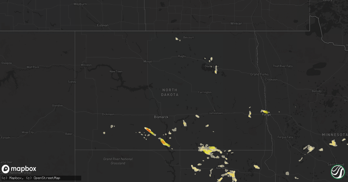
Hail Map in North Dakota on July 26, 2016
Get this storm
July 26 map
$229
one time, instant access
Download today. No call, no setup
Keep the $229
Bought the map and want the full workflow? Apply the entire $229 to a subscription within 7 days. None of it is wasted.
Every map, not just this one
This buys you this map. Subscription and you get every map we run, in the markets you choose from a few cities to whole states to nationwide. Plus real-time alerts the moment a storm fires.
Contact data
Name, contact info, occupancy, even credit band for addresses in the footprint. You go from where it hit to who to call.
Become the source they trust
Unlimited branding weather history reports on demand. You already have the documented answer ready for the property owner, and you are the one who showed up with it.
Property data and RoofTrace estimates
Pull up any address you have got, its value and the exact code rules for that jurisdiction, straight from One Click Code. Then RoofTrace estimates the squares, pitch, and roof value, priced the way you price.
Storm reports in North Dakota
North Dakota
| Date | Description |
|---|---|
| 07/26/20166:26 PM CDT | Passed on via broadcast media. |
| 07/26/20166:25 PM CDT | A local report indicates 1.50 inch wind near FLASHER |
| 07/26/20162:40 PM CDT | A brief /minute or so/ touchdown was reported by a traveller on interstate 94 near mp294...west of valley city...looking northeast across hobart lake. The touchdown app |
| 07/25/20169:40 PM CDT | Measured at fargo airport. |
| 07/25/20169:40 PM CDT | A few large 4 to 6 inch diameter tree branches broken down between edgewood and longfellow in north fargo. |
| 07/25/20169:33 PM CDT | Peak wind of 56 knots measured at the fargo airport /kfar/. |
| 07/25/20169:33 PM CDT | Peak wind of 56 knots measured at the fargo airport /kfar/. |
| 07/25/20167:50 PM CDT | Tornado was on the ground for about a minute. No damage was reported. Information was relayed via social media and broadcast media. Time and location of touchdown were |
| 07/25/20167:45 PM CDT | Winds gusting to an estimated 45 mph. |
All States Impacted by Hail Map on July 26, 2016
Cities Impacted by Hail Map on July 26, 2016
- Roy, MT
- Winnett, MT
- Harrison, NE
- Torrington, WY
- Shamrock, TX
- Buffalo, WY
- Smithwick, SD
- Hot Springs, SD
- Oelrichs, SD
- Edenton, NC
- Culpeper, VA
- Stratford, SD
- Conde, SD
- Andover, SD
- Groton, SD
- Rapidan, VA
- Unionville, VA
- Hurley, WI
- Mercer, WI
- Winner, SD
- Hawk Springs, WY
- Bowdle, SD
- Forbes, ND
- Newcastle, WY
- Lower Brule, SD
- Eckerman, MI
- Paradise, MI
- Alexandria, MN
- Manitowish Waters, WI
- Presque Isle, WI
- Skandia, MI
- Callaway, NE
- Sayner, WI
- Boulder Junction, WI
- Woodruff, WI
- Brewster, NE
- Valentine, NE
- Babb, MT
- Raleigh, ND
- Saint Francis, SD
- Buffalo Gap, SD
- Chadron, NE
- Custer, SD
- Oral, SD
- Hay Springs, NE
- Alliance, NE
- Newberry, MI
- Grand Marais, MI
- Seney, MI
- Browning, MT
- Shenandoah, VA
- Stanley, VA
- Broken Bow, NE
- Chapel Hill, NC
- Tarzan, TX
- Lenorah, TX
- Cushing, MN
- Little Falls, MN
- Pierz, MN
- Fort Ripley, MN
- Randall, MN
- Brainerd, MN
- Kennebec, SD
- Sargent, NE
- Roscoe, SD
- South Hill, VA
- La Crosse, VA
- Rush City, MN
- Hayes, SD
- Midland, SD
- Big Sandy, MT
- Rushville, NE
- Ipswich, SD
- Keystone, SD
- Lamar, CO
- Flasher, ND
- Mission, SD
- Mills, NE
- Grenville, SD
- Peever, SD
- Jackson, OH
- Stone Lake, WI
- Shell Lake, WI
- Sarona, WI
- Spooner, WI
- Hamill, SD
- Gregory, SD
- Cody, NE
- Nashwauk, MN
- Hinckley, MN
- Frederick, SD
- Hermosa, SD
- Miltona, MN
- Eagle Bend, MN
- Havre, MT
- Harwood, ND
- Fargo, ND
- Hertel, WI
- Webster, WI
- Frederic, WI
- Siren, WI
- Gillette, WY
- Presho, SD
- Bird City, KS
- Two Dot, MT
- Wheatland, WY
- Emporia, VA
- Wolsey, SD
- Bethel, OH
- Hamersville, OH
- Glen Flora, WI
- Mechanicsville, VA
- Solen, ND
- Draper, SD
- Murdo, SD
- Warwick, ND
- Jamestown, ND
- Anselmo, NE
- Westerville, NE
- Taylor, NE
- Johnstown, NE
- Ansley, NE
- Burwell, NE
- Arcadia, NE
- Comstock, NE
- Ainsworth, NE
- Chinook, MT
- Summit, SD
- Wood Lake, NE
- Colome, SD
- Rapid River, MI
- Wetmore, MI
- Wheatland, ND
- Glenwood, MN
- Starbuck, MN
- Lowry, MN
- West Union, OH
- Stout, OH
- Blue Creek, OH
- Merriman, NE
- Edgemont, SD
- Dallas, SD
- Hawley, MN
- Watersmeet, MI
- Carpenter, SD
- Crawford, NE
- Ashby, NE
- Holloway, MN
- Appleton, MN
- Long Lake, SD
- Leola, SD
- Aberdeen, SD
- New Richmond, OH
- Moscow, OH
- California, KY
- Amelia, OH
- Ashley, ND
- Winifred, MT
- Winthrop, WA
- Purdum, NE
- Dunning, NE
- Carlos, MN
- Holly, CO
- Sheridan Lake, CO
- Elgin, ND
- Fort Yates, ND
- Strasburg, ND
- Linton, ND
- Reliance, SD
- Yoder, WY
- Tilden, TX
- New England, ND
- Park Hill, OK
- Georgetown, OH
- Denton, MT
- Huron, SD
- Ellendale, ND
- Rustburg, VA
- Cresbard, SD
- Hillman, MN
- Garrison, MN
- Gainesville, TX
- Webster, ND
- Isle, MN
- Mora, MN
- Northville, SD
- Mellette, SD
- Rapelje, MT
- Whitney, NE
- Dunseith, ND
- Thedford, NE
- Tuthill, SD
- Lawrenceville, VA
- Gasburg, VA
- Medina, ND
- Wellington, TX
- Regent, ND
- Sandstone, MN
- Brook Park, MN
- Rudyard, MI
- Kinross, MI
- Phillips, WI
- Kilgore, NE
- Carson, ND
- Lloyd, MT
- Gordon, NE
- Raymond, SD
- Turton, SD
- Doland, SD
- Long Prairie, MN
- Burtrum, MN
- Swanville, MN
- New Johnsonville, TN
- Fort Pierre, SD
- Bumpass, VA
- Partlow, VA
- Spotsylvania, VA
- Richmond, VA
- Pine Ridge, SD
- Wessington, SD
- Saint Lawrence, SD
- Cary, NC
- Durham, NC
- Apex, NC
- Twisp, WA
- Cunningham, TN
- Cumberland Furnace, TN
- Miller, SD
- Dryden, TX
- Kaycee, WY
- Murdock, MN
- Benson, MN
- Brookneal, VA
- Phenix, VA
- Barbeau, MI
- Pickford, MI
- Dafter, MI
- Willow City, ND
- Wood, SD
- White River, SD
- Redfield, SD
- Rockham, SD
- Bassett, NE
- Long Pine, NE
- Lynchburg, VA
- Marsland, NE
- McKenzie, TN
- Jud, ND
- Arnold, NE
- Vivian, SD
- Burke, SD
- Ideal, SD
- Houghton, SD
- Columbia, SD
- Grantsburg, WI
- Pine City, MN
- Bloxom, VA
- Medina, TN
- Milan, TN
- Devils Lake, ND
- Kit Carson, CO
- Ferney, SD
- Mansfield, SD
- Warner, SD
- Holladay, TN
- Bath, SD
- Wahkon, MN
- Onamia, MN
- Hemingford, NE
- Lac Du Flambeau, WI
- Park Falls, WI
- Minocqua, WI
- Pittsboro, NC
- New Hill, NC
- Moncure, NC
- Mott, ND
- Gackle, ND
- Birchwood, WI
- Mullen, NE
- Harrisonburg, VA
- Keezletown, VA
- Mitchell, NE
- Morrill, NE
- Lyman, NE
- New Market, VA
- Sault Sainte Marie, MI
- Crary, ND
- Chetopa, KS
- Parmelee, SD
- Crookston, NE
- Burns, WY
- Sardinia, OH
- Osakis, MN
- Nelson, MN
- Karval, CO
- Lusk, WY
- Martin, SD
- Clarendon, TX
- Holly Springs, NC
- Springbrook, WI
- Ayr, ND
- Vernon, CO
- Anderson, MO
- Camden, NC
- Shawboro, NC
- Hecla, SD
- Brodnax, VA
- Tahlequah, OK
- Lexington, TN
- Steele, ND
- Napoleon, ND
- Kintyre, ND
- Springview, NE
- Hosmer, SD
- Vona, CO
- Barnard, SD
- West Fargo, ND
- Moorhead, MN
- Whitman, NE
- Norris, SD
- Buffalo, ND
- Mineral, VA
- Edgeley, ND
- Flagler, CO
- Broadway, VA
- Lead, SD
- Fredonia, ND
- Westport, SD
- Hazelton, ND
- Montpelier, VA
- Hill City, SD
- Erin, TN
- Hollow Rock, TN
- Bruceton, TN
- Kiowa, CO
- Oacoma, SD
- Camden, TN
- Tulare, SD
- Hitchcock, SD
- Welch, OK
- Story, WY
- Cannon Ball, ND
- Cut Bank, MT
- Conover, WI
- Concord, VA
- Danvers, MN
- Montevideo, MN
- South Mills, NC
- Crystal Falls, MI
- Manila, AR
- Thompsons Station, TN
- College Grove, TN
- Franklin, TN
- Manistique, MI
- Cooks, MI
- Ellsworth, NE
- Madison Heights, VA
- Frankfort, SD
- Marenisco, MI
- Wakefield, MI
- Beaverdam, VA
- Gates, NC
- Faulkton, SD
- Chase City, VA
- Miami, OK
- Shields, ND
- Gaston, NC
- Valentines, VA
- Glen Allen, VA
- Eads, CO
- Okreek, SD
- Noel, MO
- Pineville, MO
- Churchs Ferry, ND
- Nolensville, TN
- Dickson, TN
- Vanleer, TN
- Ogema, MN
- Land O'Lakes, WI
- Tripoli, WI
- Luray, VA
- Newcastle, OK


