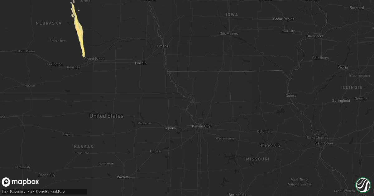
Hail Map in Nebraska on July 24, 2013
Get this storm
July 24 map
$229
one time, instant access
Download today. No call, no setup
Keep the $229
Bought the map and want the full workflow? Apply the entire $229 to a subscription within 7 days. None of it is wasted.
Every map, not just this one
This buys you this map. Subscription and you get every map we run, in the markets you choose from a few cities to whole states to nationwide. Plus real-time alerts the moment a storm fires.
Contact data
Name, contact info, occupancy, even credit band for addresses in the footprint. You go from where it hit to who to call.
Become the source they trust
Unlimited branding weather history reports on demand. You already have the documented answer ready for the property owner, and you are the one who showed up with it.
Property data and RoofTrace estimates
Pull up any address you have got, its value and the exact code rules for that jurisdiction, straight from One Click Code. Then RoofTrace estimates the squares, pitch, and roof value, priced the way you price.
Storm reports in Nebraska
Nebraska
| Date | Description |
|---|---|
| 07/24/20136:55 PM CDT | A local report indicates 66 MPH wind near 6 NNE OGALLALA |
| 07/24/20136:55 PM CDT | A local report indicates 66 MPH wind near 3 WSW OGALLALA |
| 07/24/20136:37 PM CDT | Two-story barn heavily damaged with one wall having collapsed. Multiple grain bins were also pushed over and blown around. Time estimated from radar. |
| 07/24/20136:18 PM CDT | 4 miles east of ord...emergency manager reports a house received significant wind and hail damage. The roof was peeled back 8-10 feet...exposing the inside of the house |
| 07/24/20136:18 PM CDT | Corected location. 4 miles east/southeast of ord...emergency manager reports a house received significant wind and hail damage. The roof was peeled back 8-10 feet...exp |
| 07/24/20136:18 PM CDT | A local report indicates 60 MPH wind near ORD AIRPORT |
| 07/24/20136:17 PM CDT | Golf ball size hail on the north side of ord with estimated 60 mph winds. |
| 07/24/20136:15 PM CDT | One inch hail and estimated 60 mph winds reported 1 mile north of ord. |
| 07/24/20135:45 PM CDT | Strong wind gusts estimated to 70 mph uprooted a large tree that fell on a roof. |
| 07/24/20135:30 PM CDT | Broke out cars windshield. |
| 07/24/20135:22 PM CDT | Hail fell for five minutes. |
| 07/24/20135:20 PM CDT | Hail drifts in the yard with hail a few feet deep in the ditch |
| 07/24/20133:49 PM CDT | A local report indicates 1.00 inch wind near STUART |
| 07/24/20133:48 PM CDT | A local report indicates 1.00 inch wind near STUART |
| 07/24/20133:40 PM CDT | A local report indicates 1.00 inch wind near 3 NW STUART |
| 07/24/20133:28 PM CDT | A local report indicates 1.00 inch wind near 3 WNW BEREA |
| 07/24/20133:16 PM CDT | A local report indicates 1.00 inch wind near 16 S HAY SPRINGS |
| 07/24/20133:14 PM CDT | Motorist driving 15 miles south of hay springs reported heavy rain and hail marbles to golf balls. |
| 07/24/20133:00 PM CDT | Event duration 7 minutes. |
| 07/24/20132:38 PM CDT | A local report indicates 2.75 inch wind near 7 SW HEMINGFORD |
| 07/24/20132:30 PM CDT | A local report indicates 2.75 inch wind near 7 SW HEMINGFORD |
| 07/24/20132:27 PM CDT | Event duration 16 minutes. |
| 07/24/20132:10 PM CDT | Event duration 15 minutes. |
| 07/23/20137:28 PM CDT | Howard county law enforcement relayed a public report of quarter to ping pong size hail with winds estimated at 50 - 60 mph. |
| 07/23/20137:10 PM CDT | A local report indicates 66 MPH wind near 6 NNE OGALLALA |
| 07/23/20137:00 PM CDT | Public report of ping pong size hail. |
All States Impacted by Hail Map on July 24, 2013
Cities Impacted by Hail Map on July 24, 2013
- Keysville, VA
- Wasta, SD
- Howes, SD
- Crawford, NE
- Hanna, WY
- Saco, MT
- Hinsdale, MT
- Glendo, WY
- Hemingford, NE
- Glendive, MT
- Wolf Point, MT
- Glasgow, MT
- Vandalia, MT
- Harrison, NE
- Plainview, TX
- Alliance, NE
- Broadwater, NE
- Angora, NE
- Lisco, NE
- Bridgeport, NE
- Floweree, MT
- Power, MT
- Circle, MT
- Casper, WY
- Pueblo, CO
- Nashua, MT
- Wall, SD
- Sedalia, CO
- Woodland Park, CO
- Sidney, NE
- Bloomfield, MT
- Fort Bliss, TX
- Cloudcroft, NM
- Richey, MT
- Friona, TX
- Muleshoe, TX
- Hay Springs, NE
- Albin, WY
- Pine Bluffs, WY
- Enning, SD
- Claude, TX
- Newell, SD
- Aurora, NC
- Burns, WY
- Boyes, MT
- Hammond, MT
- Kenton, OK
- Boise City, OK
- Long Prairie, MN
- Valier, MT
- Cut Bank, MT
- Rogers, NM
- Cohagen, MT
- Sand Springs, MT
- Forsyth, MT
- Union Center, SD
- Terry, MT
- Glenrock, WY
- Douglas, WY
- Great Falls, MT
- Dutton, MT
- Socorro, NM
- Lagrange, WY
- Clayton, NM
- Payson, AZ
- Broadus, MT
- Alzada, MT
- Whitney, NE
- Carpenter, WY
- Babb, MT
- Ericson, NE
- North Loup, NE
- Burwell, NE
- Ord, NE
- Cheyenne, WY
- Brockway, MT
- Jordan, MT
- Vida, MT
- Browning, MT
- Malta, MT
- Marsland, NE
- Hereford, TX
- Lodgepole, NE
- Walsh, CO
- Campo, CO
- Lyons, CO
- Lindsay, MT
- Howard, CO
- Harrisburg, NE
- Hawk Springs, WY
- Fort Peck, MT
- Wheatland, WY
- Manville, WY
- Lancaster, MN
- Frazer, MT
- Cairo, NE
- Ravenna, NE
- Sunland Park, NM
- Santa Teresa, NM
- El Paso, TX
- Westcliffe, CO
- Amarillo, TX
- Gladstone, VA
- Lockney, TX
- Shawnee, WY
- Bosler, WY
- Salida, CO
- Monument, CO
- Colorado Springs, CO
- Melrose, MN
- Sauk Centre, MN
- Grey Eagle, MN
- Ashton, NE
- Brady, MT
- Choteau, MT
- Conrad, MT
- Roswell, NM
- Adrian, TX
- Yoder, WY
- Quitaque, TX
- Sebeka, MN
- Fort Gaines, GA
- Canyon, TX
- Elgin, OK
- Elizabethtown, NC
- Larslan, MT
- Zortman, MT
- Brusett, MT
- Dodson, MT
- Moultrie, GA
- Prospect, VA
- Cullen, VA
- Meherrin, VA
- Farmville, VA
- Charlotte Court House, VA
- Pamplin, VA
- Warrenton, NC
- Macon, NC
- Hollister, NC
- Littleton, NC
- Geyser, MT
- Chinook, MT
- Lloyd, MT
- Hays, MT
- Tulia, TX
- Happy, TX
- Estancia, NM
- Rapid City, SD
- Nisland, SD
- Star, NC
- Seagrove, NC
- Hartsfield, GA
- Raleigh, NC
- Chugwater, WY
- Raynesford, MT
- Roaring River, NC
- North Wilkesboro, NC
- Monahans, TX
- Pyote, TX
- Grenville, NM
- Robbins, NC
- Abbeville, AL
- Shorterville, AL
- Concord, NC
- Walsenburg, CO
- Lake George, CO
- Eunice, NM
- Farwell, NE
- Boelus, NE
- Rockville, NE
- Elba, NE
- Amelia, NE
- Belle Fourche, SD
- Brodnax, VA
- La Crosse, VA
- Fowler, CO
- Tallahassee, FL
- Thief River Falls, MN
- Viking, MN
- Newfolden, MN
- Pitkin, LA
- Marion, NC
- Truth Or Consequences, NM
- Eagle Bend, MN
- Shamrock, TX
- Fosston, MN
- Lengby, MN
- Claunch, NM
- Conchas Dam, NM
- Trementina, NM
- Trenton, NC
- Pink Hill, NC
- Richfield, KS
- Dalton, NE
- Eagle Springs, NC
- Fort Davis, TX
- Volborg, MT
- Peyton, CO
- Chappell, NE
- Lovington, NM
- Quitman, GA
- Wildorado, TX
- Sand Coulee, MT
- Belt, MT
- South Hill, VA
- Kenbridge, VA
- Trinidad, CO
- Grover, CO
- Stuart, NE
- Atkinson, NE
- Newport, NE
- Coolidge, GA
- Pavo, GA
- Yoder, CO
- Appomattox, VA
- Magdalena, NM
- Otter, MT
- Aguilar, CO
- Weston, CO
- Kress, TX
- Mescalero, NM
- Clarendon, TX
- Lelia Lake, TX
- Scotia, NE
- Loup City, NE
- Elyria, NE
- Dimmitt, TX
- Fairfield, NC
- Thomasville, GA
- Ronda, NC
- Cedar City, UT
- Avondale, CO
- Carrizozo, NM
- Freeport, MN
- Lunenburg, VA
- Douglas, AZ
- Portales, NM
- Windsor, NC
- O'Brien, FL
- Laramie, WY
- Brookwood, AL
- Shelton, NE
- Norman Park, GA
- Villa Grove, CO
- Ponsford, MN
- Detroit Lakes, MN
- Osage, MN
- Shawnee, CO
- Cotopaxi, CO
- Eufaula, AL
- Vado, NM
- Barney, GA
- Newton, NC
- Hickory, NC
- Rock River, WY
- Boulder, UT
- Mangum, OK
- Chambers, NE
- Canon City, CO
- Jal, NM
- Allenspark, CO
- Fe Warren Afb, WY
- Andrews, TX
- Boone, CO
- Menahga, MN
- Wheeler, TX
- Larkspur, CO
- Suffolk, VA
- Lyman, NE
- Carter, MT
- Highwood, MT


