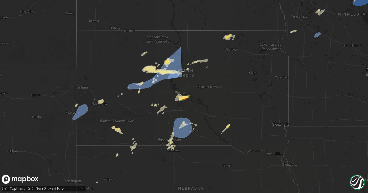
Hail Map in South Dakota on July 22, 2025
Get this storm
July 22 map
$229
one time, instant access
Download today. No call, no setup
Keep the $229
Bought the map and want the full workflow? Apply the entire $229 to a subscription within 7 days. None of it is wasted.
Every map, not just this one
This buys you this map. Subscription and you get every map we run, in the markets you choose from a few cities to whole states to nationwide. Plus real-time alerts the moment a storm fires.
Contact data
Name, contact info, occupancy, even credit band for addresses in the footprint. You go from where it hit to who to call.
Become the source they trust
Unlimited branding weather history reports on demand. You already have the documented answer ready for the property owner, and you are the one who showed up with it.
Property data and RoofTrace estimates
Pull up any address you have got, its value and the exact code rules for that jurisdiction, straight from One Click Code. Then RoofTrace estimates the squares, pitch, and roof value, priced the way you price.
Storm reports in South Dakota
South Dakota
| Date | Description |
|---|---|
| 07/22/202510:30 AM CDT | Call from public with estimated winds and 0.77 in rain. |
| 07/22/20256:56 AM CDT | A local report indicates 73 MPH wind near 8 NNW Harrison |
| 07/22/20256:55 AM CDT | Report via social media. Hail the size of a pheasant egg |
| 07/22/20256:51 AM CDT | A local report indicates 59 MPH wind near 4 SSE Witten |
| 07/22/20256:15 AM CDT | Sd mesonet site near la plant. |
| 07/22/20256:15 AM CDT | A local report indicates 75 MPH wind near 10 NW Okobojo Creek Rec |
| 07/22/20256:15 AM CDT | Sd mesonet site near la pla |
| 07/22/20256:09 AM CDT | Personal weather station. |
| 07/22/20255:40 AM CDT | Personal weather station. |
| 07/22/20254:35 AM CDT | A local report indicates 66 MPH wind near 2 SW Bridger |
| 07/22/20253:20 AM CDT | A local report indicates 59 MPH wind near 3 NW Wasta |
| 07/22/20251:15 AM CDT | A local report indicates 64 MPH wind near 10 W Jewel Cave |
All States Impacted by Hail Map on July 22, 2025
Cities Impacted by Hail Map on July 22, 2025
- Midland, SD
- Belvidere, SD
- Okaton, SD
- Murdo, SD
- Fifty Lakes, MN
- Pine River, MN
- Leola, SD
- Frederick, SD
- Westport, SD
- Columbia, SD
- Mcgregor, MN
- Palisade, MN
- Jacobson, MN
- Henning, MN
- Ottertail, MN
- New York Mills, MN
- Deer Creek, MN
- Wadena, MN
- Bluffton, MN
- Cordesville, SC
- Damascus, GA
- Blakely, GA
- Bainbridge, GA
- Okeechobee, FL
- Johns Island, SC
- Ravenel, SC
- Crosslake, MN
- Crosby, MN
- Emily, MN
- Merrifield, MN
- Pequot Lakes, MN
- Aitkin, MN
- Outing, MN
- Tallahassee, FL
- Tuskegee, AL
- Crawfordville, FL
- Monticello, FL
- Hollywood, SC
- Swatara, MN
- Hill City, MN
- Worland, WY
- Thermopolis, WY
- Summerton, SC
- Clayton, AL
- Eufaula, AL
- Abbeville, AL
- Clopton, AL
- Tamarack, MN
- Limon, CO
- Wright, MN
- Floodwood, MN
- Clio, AL
- Gettysburg, SD
- Rush, CO
- Cromwell, MN
- Meadowlands, MN
- Brookston, MN
- Alborn, MN
- White River, SD
- Hoven, SD
- Fort Stockton, TX
- Yoder, CO
- Fort Pierre, SD
- Keysville, GA
- Kite, GA
- Wrightsville, GA
- Cloquet, MN
- Saginaw, MN
- Forest Grove, MT
- Tolstoy, SD
- Tallassee, AL
- Louisville, GA
- Fort Lauderdale, FL
- Grass Range, MT
- Wadley, GA
- Onaka, SD
- Panama City, FL
- Presho, SD
- Pine Ridge, SD
- Bonifay, FL
- Winnett, MT
- Dryden, TX
- Youngstown, FL
- Pierre, SD
- Arriba, CO
- Swainsboro, GA
- Ridgeland, SC
- Hardeeville, SC
- Rincon, GA
- Lynnville, TN
- Guyton, GA
- Flagler, CO
- Dellrose, TN
- Lynn Haven, FL
- Elbert, CO
- Iraan, TX
- Kyle, SD
- Calhan, CO
- Manderson, SD
- Colorado Springs, CO
- Larkspur, CO
- Collyer, KS
- Deatsville, AL
- Prattville, AL
- Seneca, SD
- Eagleville, MO
- Hatfield, MO
- Kaycee, WY
- Quinter, KS
- Ebro, FL
- Cheyenne Wells, CO
- Springfield, GA
- Big Lake, TX
- Huger, SC
- Ridgeway, MO
- Ozona, TX
- Panama City Beach, FL
- Banner, WY
- Morland, KS
- Park, KS
- Midland, TX
- Hoxie, KS
- Bloomfield, IA
- Drakesville, IA
- Garden City, TX
- Kit Carson, CO
- Ottumwa, IA
- Blakesburg, IA
- Clearmont, WY
- Ponce De Leon, FL
- La Junta, CO
- Staples, MN
- Lorimor, IA
- Albia, IA
- Grady, AL
- Nisswa, MN
- Lovilia, IA
- White Sands Missile Range, NM
- Murray, IA
- Winterset, IA
- Norcross, MN
- Alliance, NE
- Lapine, AL
- Goshen, AL
- Sterling, CO
- Wheaton, MN
- Highland Home, AL
- Luverne, AL
- Bussey, IA
- McDonald, KS
- Floris, IA
- Selma, IA
- Levelland, TX
- Hay Springs, NE
- Sidney, NE
- Stanton, TX
- Elbow Lake, MN
- Tarzan, TX
- Richey, MT
- Lamesa, TX
- Gail, TX
- White Sulphur Springs, MT
- Muleshoe, TX
- Newton, IA
- Tucson, AZ
- Florence, AZ
- Bloomfield, MT
- Fluvanna, TX
- Lambert, MT
- Savage, MT
- Sidney, MT
- Quemado, TX
- Baxter, IA
- Rhodes, IA
- Brackettville, TX
- Melbourne, IA
- Plainview, TX
- Amarillo, TX
- Douglas, WY
- Kress, TX
- Hale Center, TX
- Littlefield, TX
- Fieldton, TX
- Olton, TX
- Amherst, TX
- Meadow, TX
- Wolfforth, TX
- Tahoka, TX
- Brownfield, TX
- Tulia, TX
- Ropesville, TX
- Lubbock, TX
- Shallowater, TX
- Fleming, CO
- Claude, TX
- Castle Rock, CO
- Sedalia, CO
- Parker, CO
- Englewood, CO
- Lone Tree, CO
- Aurora, CO
- Eddyville, IA
- Hedrick, IA
- Fremont, IA
- Alexandria, MN
- Lowry, MN
- Sanborn, ND
- Valley City, ND
- Newcastle, WY
- Hill City, SD
- Custer, SD
- Edgemont, SD
- Prairie Du Chien, WI
- Potter, NE
- Rapid City, SD
- Black Hawk, SD
- Bayard, NE
- Lisbon, ND
- Bagley, WI
- Bloomington, WI
- Cassville, WI
- Box Elder, SD
- Ellsworth Afb, SD
- Piedmont, SD
- Glen Haven, WI
- Hereford, TX
- New Underwood, SD
- Wasta, SD
- Wall, SD
- Howes, SD
- Milesville, SD
- Dupree, SD
- Cherry Creek, SD
- Union Center, SD
- Enning, SD
- White Owl, SD
- Meadow, SD
- Merriman, NE
- Eagle Butte, SD
- Lantry, SD
- Solway, MN
- Gordon, NE
- Martin, SD
- Crookston, NE
- Bemidji, MN
- Laporte, MN
- Valentine, NE
- Ridgeview, SD
- Saint Francis, SD
- Mission, SD
- Federal Dam, MN
- Batesland, SD
- Cass Lake, MN
- Wood, SD
- Platte, SD
- Agar, SD
- Bena, MN
- Park Rapids, MN
- Winner, SD
- Corsica, SD
- Stickney, SD
- Harrison, SD
- Hamill, SD
- Deer River, MN
- Ideal, SD
- Witten, SD
- Nevis, MN
- Hayes, SD
- Glenham, SD
- Mobridge, SD
- Onida, SD
- Okreek, SD


