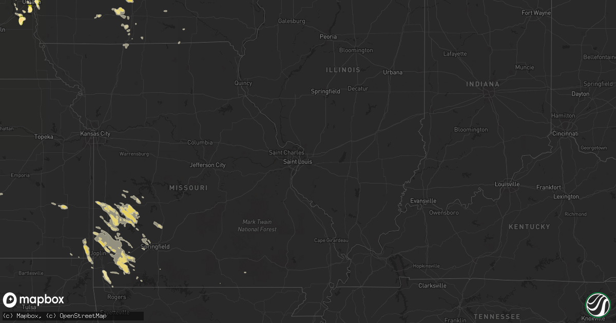
Hail Map in North Dakota on July 21, 2013
Get this storm
July 21 map
$229
one time, instant access
Download today. No call, no setup
Keep the $229
Bought the map and want the full workflow? Apply the entire $229 to a subscription within 7 days. None of it is wasted.
Every map, not just this one
This buys you this map. Subscription and you get every map we run, in the markets you choose from a few cities to whole states to nationwide. Plus real-time alerts the moment a storm fires.
Contact data
Name, contact info, occupancy, even credit band for addresses in the footprint. You go from where it hit to who to call.
Become the source they trust
Unlimited branding weather history reports on demand. You already have the documented answer ready for the property owner, and you are the one who showed up with it.
Property data and RoofTrace estimates
Pull up any address you have got, its value and the exact code rules for that jurisdiction, straight from One Click Code. Then RoofTrace estimates the squares, pitch, and roof value, priced the way you price.
Storm reports in North Dakota
North Dakota
| Date | Description |
|---|---|
| 07/21/20136:55 PM CDT | Crop damage. Leaves off of trees. Little wind. 0.60 inches of rain. Hail lasted 5 minutes with the largest stones lasting 3 minutes. |
| 07/21/20136:15 PM CDT | Also reported heavy rain. Spotter was driving home when he ran into the storm. |
| 07/21/20135:45 PM CDT | Quarter to golf ball size hail lasted for 15 minutes. Crops were heavily damaged. |
| 07/21/20135:42 PM CDT | Aircraft reports a small tornado on the ground... Nearing houses 6 to 7 miles nnw of granville |
| 07/21/20135:27 PM CDT | A local report indicates 2.75 inch wind near HEBRON |
| 07/21/20135:24 PM CDT | A local report indicates 1.75 inch wind near HEBRON |
| 07/21/20135:20 PM CDT | A local report indicates 1.75 inch wind near 10 NW HEBRON |
| 07/21/20135:15 PM CDT | A local report indicates 2.00 inch wind near 10 NW HEBRON |
| 07/21/20135:00 PM CDT | Wind between 50 and 60 mph |
| 07/21/20134:57 PM CDT | A lot of damage |
| 07/21/20134:56 PM CDT | Some crop damage |
| 07/21/20134:45 PM CDT | Hailing and raining heavily |
| 07/21/20134:29 PM CDT | A local report indicates 60 MPH wind near NEW TOWN |
| 07/21/20134:29 PM CDT | Very heavy rain... Hail lasted 15 minutes. |
| 07/21/20134:22 PM CDT | Hailing heavily - quarter size |
| 07/21/20134:15 PM CDT | A local report indicates 1.75 inch wind near 12 SW KILLDEER |
| 07/21/20133:45 PM CDT | Late report from 7-21-13. Estimated ping pong ball size hail at white earth. |
| 07/21/20133:37 PM CDT | Heavy rain... Large hail. |
| 07/21/20133:30 PM CDT | Late report from 7-21-13. Golf ball size hail south of tioga. |
| 07/21/20133:00 PM CDT | A local report indicates 1.25 inch wind near 8 S ARNEGARD |
| 07/21/201312:00 AM CDT | Estimated range of sizes...up to golf ball size. |
| 07/20/201311:40 PM CDT | A local report indicates 1.00 inch wind near REYNOLDS |
| 07/20/201311:40 PM CDT | A local report indicates 1.75 inch wind near 11 W BUXTON |
| 07/20/201311:37 PM CDT | A local report indicates 1.75 inch wind near HATTON |
| 07/20/201311:30 PM CDT | Some larger stones |
| 07/20/201311:00 PM CDT | Trees down |
| 07/20/201310:34 PM CDT | A local report indicates 1.00 inch wind near NIAGARA |
| 07/20/201310:05 PM CDT | A local report indicates 1.75 inch wind near 8 N LAKOTA |
| 07/20/20139:15 PM CDT | Hail damage to crops. Also mainly small branches down...with one uprooted tree. |
| 07/20/20139:08 PM CDT | Reported sighting of a brief tornado along hwy 20...downing a few high line wooden power poles. Time estimated from radar. |
| 07/20/20139:05 PM CDT | 3 inch branches down |
| 07/20/20137:28 PM CDT | A local report indicates 1.00 inch wind near 3 ESE MANDAN |
| 07/20/20137:21 PM CDT | A local report indicates 60 MPH wind near BISMARCK |
| 07/20/20137:20 PM CDT | A local report indicates 1.75 inch wind near MANDAN |
All States Impacted by Hail Map on July 21, 2013
Cities Impacted by Hail Map on July 21, 2013
- Sutherland, NE
- Paxton, NE
- Hatton, ND
- Buxton, ND
- Audubon, IA
- Richardton, ND
- Hamlin, IA
- Exira, IA
- Verona, MO
- Lorimor, IA
- Eagle, WI
- Register, GA
- Statesboro, GA
- Mandan, ND
- Rugby, ND
- Whitewater, WI
- Nevada, MO
- Batesland, SD
- Martin, SD
- Saint Francis, SD
- Rushville, NE
- Tuthill, SD
- Gordon, NE
- Walker, MO
- El Dorado Springs, MO
- Sheldon, MO
- Richards, MO
- Milo, MO
- New Town, ND
- Ashby, NE
- Lockwood, MO
- Golden City, MO
- Newcastle, WY
- New Effington, SD
- Burns, KS
- Stanley, ND
- Springfield, NE
- Papillion, NE
- Waterford, WI
- Rochester, WI
- Burlington, WI
- Volga, SD
- Brookings, SD
- Purdy, MO
- Monett, MO
- Mayville, ND
- Cummings, ND
- Kalamazoo, MI
- Wishek, ND
- Miami, OK
- Scammon, KS
- Northwood, ND
- Edgeley, ND
- Crawford, NE
- Hazen, ND
- Indian Mound, TN
- Martin, MI
- Otsego, MI
- Plainwell, MI
- Carson, ND
- Flasher, ND
- Hebron, ND
- Glen Ullin, ND
- Almont, ND
- Douglas, WY
- Leon, IA
- Brodhead, WI
- Orfordville, WI
- Louisville, NE
- Weeping Water, NE
- Manley, NE
- Murdock, NE
- Benton, KY
- Beulah, ND
- Brocket, ND
- Michigan, ND
- Lakota, ND
- Linton, ND
- Fort Yates, ND
- Egeland, ND
- Tappahannock, VA
- Saint Stephens Church, VA
- Unionville, IA
- Brooklyn, WI
- Lamar, MO
- Liberal, MO
- Cassoday, KS
- Stockton, MO
- Madison, SD
- Nunda, SD
- Ramona, SD
- Lawton, ND
- Deland, FL
- Dadeville, MO
- Collins, MO
- Fair Play, MO
- Humansville, MO
- Osceola, MO
- Donnybrook, ND
- Atwood, KS
- Ivanhoe, MN
- Ellendale, ND
- Pierce City, MO
- Miller, MO
- South Greenfield, MO
- Mount Vernon, MO
- Mount Vernon, GA
- Goodman, MO
- Neosho, MO
- Pineville, MO
- Anderson, MO
- Towner, ND
- Strasburg, ND
- Chadron, NE
- Starkweather, ND
- Lineville, IA
- Pollock, SD
- Eureka, SD
- Herreid, SD
- Hague, ND
- Harwood, MO
- Hume, MO
- Arcola, MO
- Jerico Springs, MO
- Williston, ND
- Dexter, KY
- Murray, KY
- Selfridge, ND
- Warrior, AL
- Trafford, AL
- Pinson, AL
- Cassville, MO
- Epping, ND
- Caledonia, ND
- Hillsboro, ND
- Kimballton, IA
- Killdeer, ND
- Manning, ND
- Curtis, NE
- Maywood, NE
- Mattawan, MI
- Fincastle, VA
- Buchanan, VA
- Sumner, TX
- Paris, TX
- Pittsburg, KS
- Freistatt, MO
- Avilla, MO
- Wentworth, MO
- Jasper, MO
- Stotts City, MO
- Carthage, MO
- Neck City, MO
- Alba, MO
- Oronogo, MO
- Asbury, MO
- Reeds, MO
- Purcell, MO
- Exeter, MO
- Butterfield, MO
- Stark City, MO
- Webb City, MO
- La Russell, MO
- Mindenmines, MO
- Granby, MO
- Aurora, MO
- Sarcoxie, MO
- Watford City, ND
- Dunn Center, ND
- Halliday, ND
- Alexander, ND
- Grassy Butte, ND
- Taylor, ND
- Fairfield, ND
- Gladstone, ND
- Arnegard, ND
- Cartwright, ND
- Petersburg, ND
- Crary, ND
- Devils Lake, ND
- Niagara, ND
- Larimore, ND
- Merriman, NE
- Benkelman, NE
- Max, NE
- Hopkinsville, KY
- Pembroke, KY
- Edmore, ND
- Adams, ND
- Flagler, CO
- Bellevue, NE
- Hampden, ND
- Cando, ND
- Murray, IA
- Thayer, IA
- Afton, IA
- Bismarck, ND
- De Smet, SD
- Bryant, SD
- Hazel, SD
- Ross, ND
- Hansboro, ND
- Rolla, ND
- Edison, NE
- Kissimmee, FL
- Oldham, SD
- La Harpe, KS
- Moran, KS
- Hindsville, AR
- Lowell, AR
- Fayetteville, AR
- Huntsville, AR
- Rogers, AR
- Springdale, AR
- Lehr, ND
- East Troy, WI
- Janesville, WI
- Footville, WI
- Evansville, WI
- Gretna, NE
- Iola, KS
- Moorefield, NE
- Wilsonville, NE
- Lebanon, NE
- Bartley, NE
- Stockville, NE
- Cambridge, NE
- Indianola, NE
- Norton, KS
- Ludell, KS
- Herndon, KS
- White Earth, ND
- Tioga, ND
- Ray, ND
- White, SD
- Lake Preston, SD
- Erwin, SD
- Orlando, FL
- New Salem, ND
- Cumberland Furnace, TN
- Saint Charles, IA
- New Virginia, IA
- Winterset, IA
- Truro, IA
- Nappanee, IN
- Wakarusa, IN
- Goshen, IN
- Solen, ND
- Naponee, NE
- Sisseton, SD
- Omaha, NE
- Elkhorn, WI
- Arlington, SD
- Shell Knob, MO
- Council Bluffs, IA
- Crownsville, MD
- Menoken, ND
- Matfield Green, KS
- Elk Horn, IA
- Guyton, GA
- Union Grove, WI
- Blythedale, MO
- Eagleville, MO
- Palmyra, WI
- Quapaw, OK
- Baxter Springs, KS
- Bolivar, MO
- Buffalo, MO
- Half Way, MO
- Fair Grove, MO
- Lake Benton, MN
- Elkton, SD
- Nevis, MN
- Akeley, MN
- Lansford, ND
- Millsboro, DE
- Georgetown, DE
- Ruthton, MN
- Stella, MO
- Hardin, KY
- Shields, ND
- Elgin, ND
- Raleigh, ND
- Decatur, IA
- Fort Eustis, VA
- Yorktown, VA
- Williamsburg, VA
- Newport News, VA
- Rocklake, ND
- Bantry, ND
- Granville, ND
- Mukwonago, WI
- Willard, MO
- Springfield, MO
- Claire City, SD
- Oshkosh, NE
- Waverly, TN
- Offutt Afb, NE
- Galena, KS
- Riverton, KS
- Columbus, KS
- Poquoson, VA
- Carmi, IL
- Pipestone, MN
- Powderly, TX
- Hershey, NE
- Parshall, ND
- Dunmor, KY
- Imperial, NE
- Keene, ND
- Berry, AL
- Bankston, AL
- Fayette, AL
- Waterloo, NE
- Elkhorn, NE
- Quincy, MO
- Sun Prairie, WI
- Marshall, WI
- Valley, NE
- Bennington, NE
- Creston, IA
- Unionville, MO
- Exline, IA
- Moulton, IA
- Martin, TN
- Rives, TN
- Union City, TN
- Harlan, IA
- Toronto, SD
- Finley, TN
- Doland, SD
- Waterville, IA
- Sturtevant, WI
- Republican City, NE
- Osceola, IA
- Mims, FL
- Beaver City, NE
- Arapahoe, NE
- Richmond, VA
- Mechanicsville, VA
- Aurora, SD
- Webster, ND
- Flagstaff, AZ
- Jackson, TN
- Belleville, WI
- Lewisburg, KY
- Ashland City, TN
- Arvilla, ND
- Deering, ND
- Astoria, SD
- Glenburn, ND
- Clear Lake, SD
- Holbrook, NE
- Colorado City, AZ
- Anton, CO
- Hendricks, MN
- Veblen, SD
- Fairview, MO
- Rocky Comfort, MO
- Rockville, MO
- Oxford, NE
- Eustis, NE
- Center, ND
- Guthrie Center, IA
- Combs, AR
- Elkins, AR
- Wesley, AR
- McKenzie, TN
- Atwood, TN
- Trezevant, TN
- North Platte, NE
- Mylo, ND
- Ponderosa, NM
- Reynolds, ND
- Thompson, ND
- Wentworth, SD
- Rutland, SD
- Peever, SD
- Elsmore, KS
- New Leipzig, ND
- Milton, WI
- Lengby, MN
- Clark, SD
- Vienna, SD
- Trenton, TN
- Lost Springs, WY
- Lexington, TN
- Reagan, TN
- Remlap, AL
- Farnam, NE
- Menahga, MN
- Park Rapids, MN
- Prescott, IA
- Cromwell, IA
- Calvert City, KY
- Alton, MO
- Severna Park, MD
- Arnold, MD
- Milan, TN
- Bradford, TN
- Coon Rapids, IA
- Powell, MO
- New Johnsonville, TN
- Alma, NE
- Chetopa, KS
- Iroquois, SD
- Heathsville, VA
- Elon, NC
- Yanceyville, NC
- Walnut Shade, MO
- Palermo, ND
- Paw Paw, MI
- Grand River, IA
- Van Wert, IA
- Columbus, WI
- Almo, KY
- Bejou, MN
- Alliance, NE
- Britton, SD
- Franksville, WI
- Champion, NE
- Glenwood, IA
- Fort Atkinson, WI
- Appleton City, MO
- Sedalia, KY
- Holland, MN
- Fayetteville, TX
- Crofton, KY
- Springfield, GA
- Russellville, AL
- Walnut Grove, MO
- Charlotte, NC
- Wheatland, WY
- Whitman, NE
- Hyannis, NE
- Bois D Arc, MO
- Ash Grove, MO
- Fosston, MN
- Mahnomen, MN
- Amelia Court House, VA
- Oakes, ND
- Reidsville, NC
- Republic, MO
- Wyandotte, OK
- Prairie City, SD
- Reva, SD
- Clermont, FL
- Brockwell, AR
- Saint Anthony, ND
- Kansasville, WI
- Geneva, FL
- Dedham, IA
- Bella Vista, AR
- Lovilia, IA
- Weir, KS
- Seneca, MO
- Gloucester, VA
- Lake City, SD
- Portland, ND
- Shelly, MN
- Edgewater, FL
- Milan, GA
- Nielsville, MN
- Bronaugh, MO
- Lankin, ND
- Fordville, ND
- Hecla, SD
- Cunningham, TN
- Clarksville, TN
- Weldon, IA
- West Plains, MO
- Pine Ridge, SD
- Cobden, IL
- Maxwell, NE
- Brooklet, GA
- Fulton, KY
- Maxbass, ND
- Lusk, WY
- Manville, WY
- Lawton, MI
- Schoolcraft, MI
- Portage, MI
- Fairdale, ND
- Arlington, NE
- Cope, CO
- Lindon, CO
- Seibert, CO
- Drake, ND
- Lance Creek, WY
- Shawnee, WY


