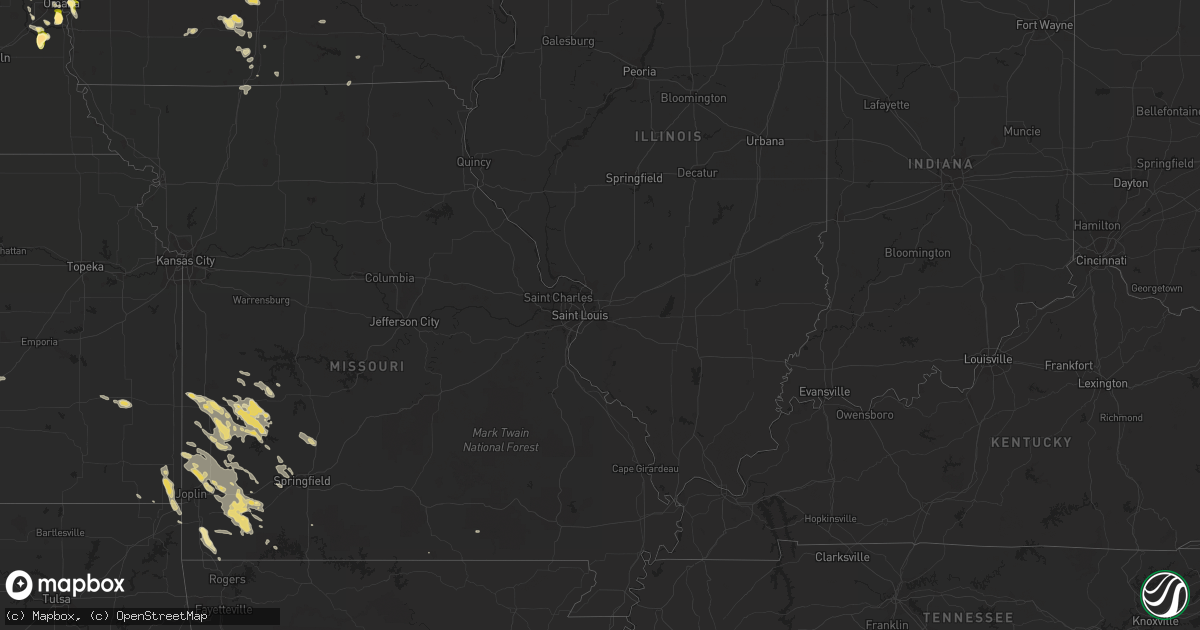
Hail Map in Missouri on July 21, 2013
Get this storm
July 21 map
$229
one time, instant access
Download today. No call, no setup
Keep the $229
Bought the map and want the full workflow? Apply the entire $229 to a subscription within 7 days. None of it is wasted.
Every map, not just this one
This buys you this map. Subscription and you get every map we run, in the markets you choose from a few cities to whole states to nationwide. Plus real-time alerts the moment a storm fires.
Contact data
Name, contact info, occupancy, even credit band for addresses in the footprint. You go from where it hit to who to call.
Become the source they trust
Unlimited branding weather history reports on demand. You already have the documented answer ready for the property owner, and you are the one who showed up with it.
Property data and RoofTrace estimates
Pull up any address you have got, its value and the exact code rules for that jurisdiction, straight from One Click Code. Then RoofTrace estimates the squares, pitch, and roof value, priced the way you price.
Storm reports in Missouri
Missouri
| Date | Description |
|---|---|
| 07/21/20134:05 AM CDT | 60 mph wind gusts and dime size hail two south of purdy. |
| 07/21/20132:05 AM CDT | A local report indicates 1.00 inch wind near NECK CITY |
| 07/20/20137:18 PM CDT | Trees and power lines down with a few windows blown out. A storm survey will be conducted on this damage this evening. |
| 07/20/20137:18 PM CDT | A nws storm survey indicated that an ef-0 tornado touched down near the intersection of east cairo street and south pickwick avenue. The tornado travelled east along ea |
All States Impacted by Hail Map on July 21, 2013
Cities Impacted by Hail Map on July 21, 2013
- Sutherland, NE
- Paxton, NE
- Hatton, ND
- Buxton, ND
- Audubon, IA
- Richardton, ND
- Hamlin, IA
- Exira, IA
- Verona, MO
- Lorimor, IA
- Eagle, WI
- Register, GA
- Statesboro, GA
- Mandan, ND
- Rugby, ND
- Whitewater, WI
- Nevada, MO
- Batesland, SD
- Martin, SD
- Saint Francis, SD
- Rushville, NE
- Tuthill, SD
- Gordon, NE
- Walker, MO
- El Dorado Springs, MO
- Sheldon, MO
- Richards, MO
- Milo, MO
- New Town, ND
- Ashby, NE
- Lockwood, MO
- Golden City, MO
- Newcastle, WY
- New Effington, SD
- Burns, KS
- Stanley, ND
- Springfield, NE
- Papillion, NE
- Waterford, WI
- Rochester, WI
- Burlington, WI
- Volga, SD
- Brookings, SD
- Purdy, MO
- Monett, MO
- Mayville, ND
- Cummings, ND
- Kalamazoo, MI
- Wishek, ND
- Miami, OK
- Scammon, KS
- Northwood, ND
- Edgeley, ND
- Crawford, NE
- Hazen, ND
- Indian Mound, TN
- Martin, MI
- Otsego, MI
- Plainwell, MI
- Carson, ND
- Flasher, ND
- Hebron, ND
- Glen Ullin, ND
- Almont, ND
- Douglas, WY
- Leon, IA
- Brodhead, WI
- Orfordville, WI
- Louisville, NE
- Weeping Water, NE
- Manley, NE
- Murdock, NE
- Benton, KY
- Beulah, ND
- Brocket, ND
- Michigan, ND
- Lakota, ND
- Linton, ND
- Fort Yates, ND
- Egeland, ND
- Tappahannock, VA
- Saint Stephens Church, VA
- Unionville, IA
- Brooklyn, WI
- Lamar, MO
- Liberal, MO
- Cassoday, KS
- Stockton, MO
- Madison, SD
- Nunda, SD
- Ramona, SD
- Lawton, ND
- Deland, FL
- Dadeville, MO
- Collins, MO
- Fair Play, MO
- Humansville, MO
- Osceola, MO
- Donnybrook, ND
- Atwood, KS
- Ivanhoe, MN
- Ellendale, ND
- Pierce City, MO
- Miller, MO
- South Greenfield, MO
- Mount Vernon, MO
- Mount Vernon, GA
- Goodman, MO
- Neosho, MO
- Pineville, MO
- Anderson, MO
- Towner, ND
- Strasburg, ND
- Chadron, NE
- Starkweather, ND
- Lineville, IA
- Pollock, SD
- Eureka, SD
- Herreid, SD
- Hague, ND
- Harwood, MO
- Hume, MO
- Arcola, MO
- Jerico Springs, MO
- Williston, ND
- Dexter, KY
- Murray, KY
- Selfridge, ND
- Warrior, AL
- Trafford, AL
- Pinson, AL
- Cassville, MO
- Epping, ND
- Caledonia, ND
- Hillsboro, ND
- Kimballton, IA
- Killdeer, ND
- Manning, ND
- Curtis, NE
- Maywood, NE
- Mattawan, MI
- Fincastle, VA
- Buchanan, VA
- Sumner, TX
- Paris, TX
- Pittsburg, KS
- Freistatt, MO
- Avilla, MO
- Wentworth, MO
- Jasper, MO
- Stotts City, MO
- Carthage, MO
- Neck City, MO
- Alba, MO
- Oronogo, MO
- Asbury, MO
- Reeds, MO
- Purcell, MO
- Exeter, MO
- Butterfield, MO
- Stark City, MO
- Webb City, MO
- La Russell, MO
- Mindenmines, MO
- Granby, MO
- Aurora, MO
- Sarcoxie, MO
- Watford City, ND
- Dunn Center, ND
- Halliday, ND
- Alexander, ND
- Grassy Butte, ND
- Taylor, ND
- Fairfield, ND
- Gladstone, ND
- Arnegard, ND
- Cartwright, ND
- Petersburg, ND
- Crary, ND
- Devils Lake, ND
- Niagara, ND
- Larimore, ND
- Merriman, NE
- Benkelman, NE
- Max, NE
- Hopkinsville, KY
- Pembroke, KY
- Edmore, ND
- Adams, ND
- Flagler, CO
- Bellevue, NE
- Hampden, ND
- Cando, ND
- Murray, IA
- Thayer, IA
- Afton, IA
- Bismarck, ND
- De Smet, SD
- Bryant, SD
- Hazel, SD
- Ross, ND
- Hansboro, ND
- Rolla, ND
- Edison, NE
- Kissimmee, FL
- Oldham, SD
- La Harpe, KS
- Moran, KS
- Hindsville, AR
- Lowell, AR
- Fayetteville, AR
- Huntsville, AR
- Rogers, AR
- Springdale, AR
- Lehr, ND
- East Troy, WI
- Janesville, WI
- Footville, WI
- Evansville, WI
- Gretna, NE
- Iola, KS
- Moorefield, NE
- Wilsonville, NE
- Lebanon, NE
- Bartley, NE
- Stockville, NE
- Cambridge, NE
- Indianola, NE
- Norton, KS
- Ludell, KS
- Herndon, KS
- White Earth, ND
- Tioga, ND
- Ray, ND
- White, SD
- Lake Preston, SD
- Erwin, SD
- Orlando, FL
- New Salem, ND
- Cumberland Furnace, TN
- Saint Charles, IA
- New Virginia, IA
- Winterset, IA
- Truro, IA
- Nappanee, IN
- Wakarusa, IN
- Goshen, IN
- Solen, ND
- Naponee, NE
- Sisseton, SD
- Omaha, NE
- Elkhorn, WI
- Arlington, SD
- Shell Knob, MO
- Council Bluffs, IA
- Crownsville, MD
- Menoken, ND
- Matfield Green, KS
- Elk Horn, IA
- Guyton, GA
- Union Grove, WI
- Blythedale, MO
- Eagleville, MO
- Palmyra, WI
- Quapaw, OK
- Baxter Springs, KS
- Bolivar, MO
- Buffalo, MO
- Half Way, MO
- Fair Grove, MO
- Lake Benton, MN
- Elkton, SD
- Nevis, MN
- Akeley, MN
- Lansford, ND
- Millsboro, DE
- Georgetown, DE
- Ruthton, MN
- Stella, MO
- Hardin, KY
- Shields, ND
- Elgin, ND
- Raleigh, ND
- Decatur, IA
- Fort Eustis, VA
- Yorktown, VA
- Williamsburg, VA
- Newport News, VA
- Rocklake, ND
- Bantry, ND
- Granville, ND
- Mukwonago, WI
- Willard, MO
- Springfield, MO
- Claire City, SD
- Oshkosh, NE
- Waverly, TN
- Offutt Afb, NE
- Galena, KS
- Riverton, KS
- Columbus, KS
- Poquoson, VA
- Carmi, IL
- Pipestone, MN
- Powderly, TX
- Hershey, NE
- Parshall, ND
- Dunmor, KY
- Imperial, NE
- Keene, ND
- Berry, AL
- Bankston, AL
- Fayette, AL
- Waterloo, NE
- Elkhorn, NE
- Quincy, MO
- Sun Prairie, WI
- Marshall, WI
- Valley, NE
- Bennington, NE
- Creston, IA
- Unionville, MO
- Exline, IA
- Moulton, IA
- Martin, TN
- Rives, TN
- Union City, TN
- Harlan, IA
- Toronto, SD
- Finley, TN
- Doland, SD
- Waterville, IA
- Sturtevant, WI
- Republican City, NE
- Osceola, IA
- Mims, FL
- Beaver City, NE
- Arapahoe, NE
- Richmond, VA
- Mechanicsville, VA
- Aurora, SD
- Webster, ND
- Flagstaff, AZ
- Jackson, TN
- Belleville, WI
- Lewisburg, KY
- Ashland City, TN
- Arvilla, ND
- Deering, ND
- Astoria, SD
- Glenburn, ND
- Clear Lake, SD
- Holbrook, NE
- Colorado City, AZ
- Anton, CO
- Hendricks, MN
- Veblen, SD
- Fairview, MO
- Rocky Comfort, MO
- Rockville, MO
- Oxford, NE
- Eustis, NE
- Center, ND
- Guthrie Center, IA
- Combs, AR
- Elkins, AR
- Wesley, AR
- McKenzie, TN
- Atwood, TN
- Trezevant, TN
- North Platte, NE
- Mylo, ND
- Ponderosa, NM
- Reynolds, ND
- Thompson, ND
- Wentworth, SD
- Rutland, SD
- Peever, SD
- Elsmore, KS
- New Leipzig, ND
- Milton, WI
- Lengby, MN
- Clark, SD
- Vienna, SD
- Trenton, TN
- Lost Springs, WY
- Lexington, TN
- Reagan, TN
- Remlap, AL
- Farnam, NE
- Menahga, MN
- Park Rapids, MN
- Prescott, IA
- Cromwell, IA
- Calvert City, KY
- Alton, MO
- Severna Park, MD
- Arnold, MD
- Milan, TN
- Bradford, TN
- Coon Rapids, IA
- Powell, MO
- New Johnsonville, TN
- Alma, NE
- Chetopa, KS
- Iroquois, SD
- Heathsville, VA
- Elon, NC
- Yanceyville, NC
- Walnut Shade, MO
- Palermo, ND
- Paw Paw, MI
- Grand River, IA
- Van Wert, IA
- Columbus, WI
- Almo, KY
- Bejou, MN
- Alliance, NE
- Britton, SD
- Franksville, WI
- Champion, NE
- Glenwood, IA
- Fort Atkinson, WI
- Appleton City, MO
- Sedalia, KY
- Holland, MN
- Fayetteville, TX
- Crofton, KY
- Springfield, GA
- Russellville, AL
- Walnut Grove, MO
- Charlotte, NC
- Wheatland, WY
- Whitman, NE
- Hyannis, NE
- Bois D Arc, MO
- Ash Grove, MO
- Fosston, MN
- Mahnomen, MN
- Amelia Court House, VA
- Oakes, ND
- Reidsville, NC
- Republic, MO
- Wyandotte, OK
- Prairie City, SD
- Reva, SD
- Clermont, FL
- Brockwell, AR
- Saint Anthony, ND
- Kansasville, WI
- Geneva, FL
- Dedham, IA
- Bella Vista, AR
- Lovilia, IA
- Weir, KS
- Seneca, MO
- Gloucester, VA
- Lake City, SD
- Portland, ND
- Shelly, MN
- Edgewater, FL
- Milan, GA
- Nielsville, MN
- Bronaugh, MO
- Lankin, ND
- Fordville, ND
- Hecla, SD
- Cunningham, TN
- Clarksville, TN
- Weldon, IA
- West Plains, MO
- Pine Ridge, SD
- Cobden, IL
- Maxwell, NE
- Brooklet, GA
- Fulton, KY
- Maxbass, ND
- Lusk, WY
- Manville, WY
- Lawton, MI
- Schoolcraft, MI
- Portage, MI
- Fairdale, ND
- Arlington, NE
- Cope, CO
- Lindon, CO
- Seibert, CO
- Drake, ND
- Lance Creek, WY
- Shawnee, WY


