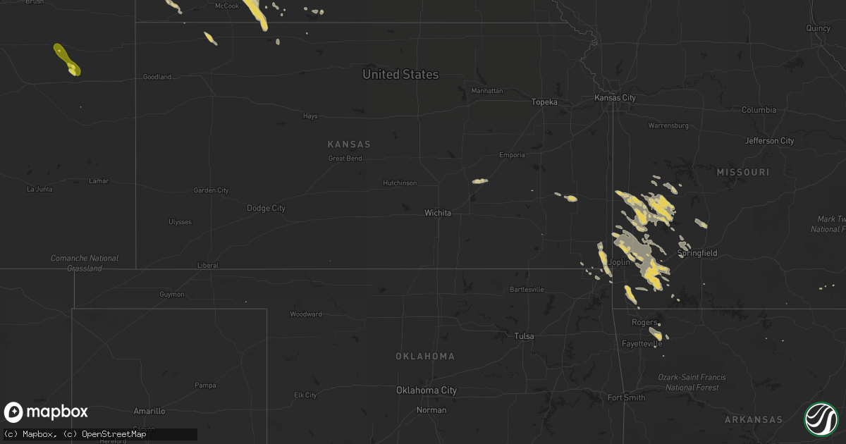
Hail Map on July 21, 2013
Get this storm
July 21 map
$229
one time, instant access
Download today. No call, no setup
Keep the $229
Bought the map and want the full workflow? Apply the entire $229 to a subscription within 7 days. None of it is wasted.
Every map, not just this one
This buys you this map. Subscription and you get every map we run, in the markets you choose from a few cities to whole states to nationwide. Plus real-time alerts the moment a storm fires.
Contact data
Name, contact info, occupancy, even credit band for addresses in the footprint. You go from where it hit to who to call.
Become the source they trust
Unlimited branding weather history reports on demand. You already have the documented answer ready for the property owner, and you are the one who showed up with it.
Property data and RoofTrace estimates
Pull up any address you have got, its value and the exact code rules for that jurisdiction, straight from One Click Code. Then RoofTrace estimates the squares, pitch, and roof value, priced the way you price.
States Impacted by Hail Map on July 21, 2013
Storm reports
Wyoming
| Date | Description |
|---|---|
| 07/21/20136:44 PM CDT | Hail up to baseball size between 544 and 549 pm mdt. |
Wisconsin
| Date | Description |
|---|---|
| 07/21/20135:15 PM CDT | Corn flattened. Time estimated from radar. |
| 07/21/20135:15 PM CDT | Corn flattened. Time estimated from radar. |
| 07/21/20135:00 PM CDT | Some of the roofing material was ripped off of a house under construction. |
| 07/21/20134:53 PM CDT | Trees down |
| 07/21/20134:40 PM CDT | Time estimated from obs and radar. |
| 07/21/20134:40 PM CDT | Damage reported to police from private residents. Trees reported down as well. |
| 07/21/20134:30 PM CDT | Reports of trees down on power lines in the east troy area. |
| 07/21/20133:30 PM CDT | Most of roof removed from home. Debris from roof caused minor damage to other homes. Possible gustnado. |
Illinois
| Date | Description |
|---|---|
| 07/21/20134:55 PM CDT | At least four trees snapped...the largest approx 12-14 inches in diameter. Several large branches also down. At palatine hills golf course. Delayed report |
Virginia
| Date | Description |
|---|---|
| 07/21/20132:30 PM CDT | Another tree down at the intersection of dolphin lane and evergreen drive |
Kansas
| Date | Description |
|---|---|
| 07/21/201312:50 AM CDT | A local report indicates 1.00 inch wind near CRESTLINE |
South Carolina
| Date | Description |
|---|---|
| 07/21/20134:58 PM CDT | Schp reports tree down near intersection of hwy 49 and hwy 9 |
Tennessee
| Date | Description |
|---|---|
| 07/21/20133:36 PM CDT | Two trees down just northwest of benton. |
Florida
| Date | Description |
|---|---|
| 07/21/20131:30 PM CDT | Multiple reports of a tornado touchdown were reported to local media. Photo confirmation has been received. Location estimated by radar. |
| 07/21/20131:24 PM CDT | Three trees were downed by thunderstorm wind gusts. Time estimated by radar. |
Missouri
| Date | Description |
|---|---|
| 07/21/20134:05 AM CDT | 60 mph wind gusts and dime size hail two south of purdy. |
| 07/21/20132:05 AM CDT | A local report indicates 1.00 inch wind near NECK CITY |
| 07/20/20137:18 PM CDT | Trees and power lines down with a few windows blown out. A storm survey will be conducted on this damage this evening. |
| 07/20/20137:18 PM CDT | A nws storm survey indicated that an ef-0 tornado touched down near the intersection of east cairo street and south pickwick avenue. The tornado travelled east along ea |
South Dakota
| Date | Description |
|---|---|
| 07/21/201312:50 AM CDT | Time estimated based on radar |
| 07/21/201312:45 AM CDT | Time estimated based on radar |
| 07/20/20139:07 PM CDT | A local report indicates 1.00 inch wind near 4 N HERREID |
Nebraska
| Date | Description |
|---|---|
| 07/21/20136:44 PM CDT | Variable 1.25 to 1.75 inch hail at 36th and hwy 370. |
| 07/21/20136:40 PM CDT | Started as quarter-sized hail and went to ping pong sized hail for about 15 minutes so far. 36th and blackhawk. |
| 07/21/20136:39 PM CDT | Nearing winding river drive. |
| 07/21/20136:36 PM CDT | 36th and hwy 370 quarter sized hail with occasional golfball sized hail. |
| 07/21/20136:31 PM CDT | 36th and cornhusker |
| 07/21/20136:23 PM CDT | A local report indicates 1.00 inch wind near BELLEVUE |
| 07/21/20132:30 AM CDT | A local report indicates 1.00 inch wind near 6 S SUTHERLAND |
| 07/20/20137:57 PM CDT | Started as 1 inch hail 10 minutes ago and is now golfball sized hail. |
| 07/20/20137:40 PM CDT | A local report indicates 1.75 inch wind near MANLEY |
| 07/20/20137:26 PM CDT | Delayed report. |
North Carolina
| Date | Description |
|---|---|
| 07/21/20133:48 PM CDT | One tree down on bama road. |
| 07/21/20133:41 PM CDT | One tree down on murphy road. |
| 07/21/20132:52 PM CDT | One tree down on a house along longbow road |
| 07/21/20132:12 PM CDT | Tree fell on a home on clayburn street in greensboro. |
| 07/21/20132:12 PM CDT | Tree fell on a home on latham road in greensboro. |
Minnesota
| Date | Description |
|---|---|
| 07/21/20133:45 AM CDT | Numerous tree damage along with some tin roofing peeled off of a shed. Time estimated from radar. |
| 07/21/20132:00 AM CDT | Reports from law enforcement indicate a band of wind damage from 8 e mahnomen along 230th st where a farmsted had quonset damage east to the roy lake area along the cle |
| 07/21/20131:50 AM CDT | Tornado damage path length was an intermitten 18 miles with a path width of 20 to 150 yards from 4 ese of mahnomen to 4 miles wnw of zerkel from approximately 150am to |
Michigan
| Date | Description |
|---|---|
| 07/20/20139:10 PM CDT | Multiple large trees down with blockage of 8th street just north of 112th avenue. One tree... Healthy 40 foot tall with a diameter of 12 to 14 inches... Was uprooted. |
| 07/20/20138:33 PM CDT | Hail with diameters up to an inch reported. |
| 07/20/20137:25 PM CDT | Large tree branches down |
North Dakota
| Date | Description |
|---|---|
| 07/21/20136:55 PM CDT | Crop damage. Leaves off of trees. Little wind. 0.60 inches of rain. Hail lasted 5 minutes with the largest stones lasting 3 minutes. |
| 07/21/20136:15 PM CDT | Also reported heavy rain. Spotter was driving home when he ran into the storm. |
| 07/21/20135:45 PM CDT | Quarter to golf ball size hail lasted for 15 minutes. Crops were heavily damaged. |
| 07/21/20135:42 PM CDT | Aircraft reports a small tornado on the ground... Nearing houses 6 to 7 miles nnw of granville |
| 07/21/20135:27 PM CDT | A local report indicates 2.75 inch wind near HEBRON |
| 07/21/20135:24 PM CDT | A local report indicates 1.75 inch wind near HEBRON |
| 07/21/20135:20 PM CDT | A local report indicates 1.75 inch wind near 10 NW HEBRON |
| 07/21/20135:15 PM CDT | A local report indicates 2.00 inch wind near 10 NW HEBRON |
| 07/21/20135:00 PM CDT | Wind between 50 and 60 mph |
| 07/21/20134:57 PM CDT | A lot of damage |
| 07/21/20134:56 PM CDT | Some crop damage |
| 07/21/20134:45 PM CDT | Hailing and raining heavily |
| 07/21/20134:29 PM CDT | Very heavy rain... Hail lasted 15 minutes. |
| 07/21/20134:29 PM CDT | A local report indicates 60 MPH wind near NEW TOWN |
| 07/21/20134:22 PM CDT | Hailing heavily - quarter size |
| 07/21/20134:15 PM CDT | A local report indicates 1.75 inch wind near 12 SW KILLDEER |
| 07/21/20133:45 PM CDT | Late report from 7-21-13. Estimated ping pong ball size hail at white earth. |
| 07/21/20133:37 PM CDT | Heavy rain... Large hail. |
| 07/21/20133:30 PM CDT | Late report from 7-21-13. Golf ball size hail south of tioga. |
| 07/21/20133:00 PM CDT | A local report indicates 1.25 inch wind near 8 S ARNEGARD |
| 07/21/201312:00 AM CDT | Estimated range of sizes...up to golf ball size. |
| 07/20/201311:40 PM CDT | A local report indicates 1.75 inch wind near 11 W BUXTON |
| 07/20/201311:40 PM CDT | A local report indicates 1.00 inch wind near REYNOLDS |
| 07/20/201311:37 PM CDT | A local report indicates 1.75 inch wind near HATTON |
| 07/20/201311:30 PM CDT | Some larger stones |
| 07/20/201311:00 PM CDT | Trees down |
| 07/20/201310:34 PM CDT | A local report indicates 1.00 inch wind near NIAGARA |
| 07/20/201310:05 PM CDT | A local report indicates 1.75 inch wind near 8 N LAKOTA |
| 07/20/20139:15 PM CDT | Hail damage to crops. Also mainly small branches down...with one uprooted tree. |
| 07/20/20139:08 PM CDT | Reported sighting of a brief tornado along hwy 20...downing a few high line wooden power poles. Time estimated from radar. |
| 07/20/20139:05 PM CDT | 3 inch branches down |
| 07/20/20137:28 PM CDT | A local report indicates 1.00 inch wind near 3 ESE MANDAN |
| 07/20/20137:21 PM CDT | A local report indicates 60 MPH wind near BISMARCK |
| 07/20/20137:20 PM CDT | A local report indicates 1.75 inch wind near MANDAN |
Colorado
| Date | Description |
|---|---|
| 07/20/20138:10 PM CDT | Hail lasted for 10 minutes. |
Alabama
| Date | Description |
|---|---|
| 07/21/20135:36 PM CDT | One tree down on a car. Winds estimated at 30 to 40 mph. |
Iowa
| Date | Description |
|---|---|
| 07/21/20135:06 PM CDT | Winds around 40 mph and heavy rain in addition to the hail. |
| 07/21/20134:22 PM CDT | Location estimated from radar. |
Georgia
| Date | Description |
|---|---|
| 07/21/20132:50 PM CDT | Four trees reported down on sardis church road. Time estimated by radar. |
| 07/21/20131:48 PM CDT | 911 dispatcher reported 1 large tree down on grooverville rd. |
Arkansas
| Date | Description |
|---|---|
| 07/21/20132:25 AM CDT | Tree limbs down...lawn furniture tossed. Time estimated by radar. |
| 07/21/20131:48 AM CDT | Tree limbs down...furniture tossed around. |
California
| Date | Description |
|---|---|
| 07/20/201311:50 PM CDT | Power lines were knocked down in the bishop creek area by thunderstorm winds. The event time is an estimate. |
| 07/20/201311:30 PM CDT | A few trees and powerlines were reported downed by thunderstorm winds |
| 07/20/201310:30 PM CDT | Public reports that a tree was blown down onto a mobile home located on warren street in bishop. No injuries. Amount of damage is unknown. |
| 07/20/201310:00 PM CDT | Large tree down on east line road...1/2 mile east of bishop. Tree diameter was 2.5 feet. Tree was located near a drainage ditch and likely had weakened roots. Estimated |
Cities Impacted by Hail Map on July 21, 2013
- Sutherland, NE
- Paxton, NE
- Hatton, ND
- Buxton, ND
- Audubon, IA
- Richardton, ND
- Hamlin, IA
- Exira, IA
- Verona, MO
- Lorimor, IA
- Eagle, WI
- Register, GA
- Statesboro, GA
- Mandan, ND
- Rugby, ND
- Whitewater, WI
- Nevada, MO
- Batesland, SD
- Martin, SD
- Saint Francis, SD
- Rushville, NE
- Tuthill, SD
- Gordon, NE
- Walker, MO
- El Dorado Springs, MO
- Sheldon, MO
- Richards, MO
- Milo, MO
- New Town, ND
- Ashby, NE
- Lockwood, MO
- Golden City, MO
- Newcastle, WY
- New Effington, SD
- Burns, KS
- Stanley, ND
- Springfield, NE
- Papillion, NE
- Waterford, WI
- Rochester, WI
- Burlington, WI
- Volga, SD
- Brookings, SD
- Purdy, MO
- Monett, MO
- Mayville, ND
- Cummings, ND
- Kalamazoo, MI
- Wishek, ND
- Miami, OK
- Scammon, KS
- Northwood, ND
- Edgeley, ND
- Crawford, NE
- Hazen, ND
- Indian Mound, TN
- Martin, MI
- Otsego, MI
- Plainwell, MI
- Carson, ND
- Flasher, ND
- Hebron, ND
- Glen Ullin, ND
- Almont, ND
- Douglas, WY
- Leon, IA
- Brodhead, WI
- Orfordville, WI
- Louisville, NE
- Weeping Water, NE
- Manley, NE
- Murdock, NE
- Benton, KY
- Beulah, ND
- Brocket, ND
- Michigan, ND
- Lakota, ND
- Linton, ND
- Fort Yates, ND
- Egeland, ND
- Tappahannock, VA
- Saint Stephens Church, VA
- Unionville, IA
- Brooklyn, WI
- Lamar, MO
- Liberal, MO
- Cassoday, KS
- Stockton, MO
- Madison, SD
- Nunda, SD
- Ramona, SD
- Lawton, ND
- Deland, FL
- Dadeville, MO
- Collins, MO
- Fair Play, MO
- Humansville, MO
- Osceola, MO
- Donnybrook, ND
- Atwood, KS
- Ivanhoe, MN
- Ellendale, ND
- Pierce City, MO
- Miller, MO
- South Greenfield, MO
- Mount Vernon, MO
- Mount Vernon, GA
- Goodman, MO
- Neosho, MO
- Pineville, MO
- Anderson, MO
- Towner, ND
- Strasburg, ND
- Chadron, NE
- Starkweather, ND
- Lineville, IA
- Pollock, SD
- Eureka, SD
- Herreid, SD
- Hague, ND
- Harwood, MO
- Hume, MO
- Arcola, MO
- Jerico Springs, MO
- Williston, ND
- Dexter, KY
- Murray, KY
- Selfridge, ND
- Warrior, AL
- Trafford, AL
- Pinson, AL
- Cassville, MO
- Epping, ND
- Caledonia, ND
- Hillsboro, ND
- Kimballton, IA
- Killdeer, ND
- Manning, ND
- Curtis, NE
- Maywood, NE
- Mattawan, MI
- Fincastle, VA
- Buchanan, VA
- Sumner, TX
- Paris, TX
- Pittsburg, KS
- Freistatt, MO
- Avilla, MO
- Wentworth, MO
- Jasper, MO
- Stotts City, MO
- Carthage, MO
- Neck City, MO
- Alba, MO
- Oronogo, MO
- Asbury, MO
- Reeds, MO
- Purcell, MO
- Exeter, MO
- Butterfield, MO
- Stark City, MO
- Webb City, MO
- La Russell, MO
- Mindenmines, MO
- Granby, MO
- Aurora, MO
- Sarcoxie, MO
- Watford City, ND
- Dunn Center, ND
- Halliday, ND
- Alexander, ND
- Grassy Butte, ND
- Taylor, ND
- Fairfield, ND
- Gladstone, ND
- Arnegard, ND
- Cartwright, ND
- Petersburg, ND
- Crary, ND
- Devils Lake, ND
- Niagara, ND
- Larimore, ND
- Merriman, NE
- Benkelman, NE
- Max, NE
- Hopkinsville, KY
- Pembroke, KY
- Edmore, ND
- Adams, ND
- Flagler, CO
- Bellevue, NE
- Hampden, ND
- Cando, ND
- Murray, IA
- Thayer, IA
- Afton, IA
- Bismarck, ND
- De Smet, SD
- Bryant, SD
- Hazel, SD
- Ross, ND
- Hansboro, ND
- Rolla, ND
- Edison, NE
- Kissimmee, FL
- Oldham, SD
- La Harpe, KS
- Moran, KS
- Hindsville, AR
- Lowell, AR
- Fayetteville, AR
- Huntsville, AR
- Rogers, AR
- Springdale, AR
- Lehr, ND
- East Troy, WI
- Janesville, WI
- Footville, WI
- Evansville, WI
- Gretna, NE
- Iola, KS
- Moorefield, NE
- Wilsonville, NE
- Lebanon, NE
- Bartley, NE
- Stockville, NE
- Cambridge, NE
- Indianola, NE
- Norton, KS
- Ludell, KS
- Herndon, KS
- White Earth, ND
- Tioga, ND
- Ray, ND
- White, SD
- Lake Preston, SD
- Erwin, SD
- Orlando, FL
- New Salem, ND
- Cumberland Furnace, TN
- Saint Charles, IA
- New Virginia, IA
- Winterset, IA
- Truro, IA
- Nappanee, IN
- Wakarusa, IN
- Goshen, IN
- Solen, ND
- Naponee, NE
- Sisseton, SD
- Omaha, NE
- Elkhorn, WI
- Arlington, SD
- Shell Knob, MO
- Council Bluffs, IA
- Crownsville, MD
- Menoken, ND
- Matfield Green, KS
- Elk Horn, IA
- Guyton, GA
- Union Grove, WI
- Blythedale, MO
- Eagleville, MO
- Palmyra, WI
- Quapaw, OK
- Baxter Springs, KS
- Bolivar, MO
- Buffalo, MO
- Half Way, MO
- Fair Grove, MO
- Lake Benton, MN
- Elkton, SD
- Nevis, MN
- Akeley, MN
- Lansford, ND
- Millsboro, DE
- Georgetown, DE
- Ruthton, MN
- Stella, MO
- Hardin, KY
- Shields, ND
- Elgin, ND
- Raleigh, ND
- Decatur, IA
- Fort Eustis, VA
- Yorktown, VA
- Williamsburg, VA
- Newport News, VA
- Rocklake, ND
- Bantry, ND
- Granville, ND
- Mukwonago, WI
- Willard, MO
- Springfield, MO
- Claire City, SD
- Oshkosh, NE
- Waverly, TN
- Offutt Afb, NE
- Galena, KS
- Riverton, KS
- Columbus, KS
- Poquoson, VA
- Carmi, IL
- Pipestone, MN
- Powderly, TX
- Hershey, NE
- Parshall, ND
- Dunmor, KY
- Imperial, NE
- Keene, ND
- Berry, AL
- Bankston, AL
- Fayette, AL
- Waterloo, NE
- Elkhorn, NE
- Quincy, MO
- Sun Prairie, WI
- Marshall, WI
- Valley, NE
- Bennington, NE
- Creston, IA
- Unionville, MO
- Exline, IA
- Moulton, IA
- Martin, TN
- Rives, TN
- Union City, TN
- Harlan, IA
- Toronto, SD
- Finley, TN
- Doland, SD
- Waterville, IA
- Sturtevant, WI
- Republican City, NE
- Osceola, IA
- Mims, FL
- Beaver City, NE
- Arapahoe, NE
- Richmond, VA
- Mechanicsville, VA
- Aurora, SD
- Webster, ND
- Flagstaff, AZ
- Jackson, TN
- Belleville, WI
- Lewisburg, KY
- Ashland City, TN
- Arvilla, ND
- Deering, ND
- Astoria, SD
- Glenburn, ND
- Clear Lake, SD
- Holbrook, NE
- Colorado City, AZ
- Anton, CO
- Hendricks, MN
- Veblen, SD
- Fairview, MO
- Rocky Comfort, MO
- Rockville, MO
- Oxford, NE
- Eustis, NE
- Center, ND
- Guthrie Center, IA
- Combs, AR
- Elkins, AR
- Wesley, AR
- McKenzie, TN
- Atwood, TN
- Trezevant, TN
- North Platte, NE
- Mylo, ND
- Ponderosa, NM
- Reynolds, ND
- Thompson, ND
- Wentworth, SD
- Rutland, SD
- Peever, SD
- Elsmore, KS
- New Leipzig, ND
- Milton, WI
- Lengby, MN
- Clark, SD
- Vienna, SD
- Trenton, TN
- Lost Springs, WY
- Lexington, TN
- Reagan, TN
- Remlap, AL
- Farnam, NE
- Menahga, MN
- Park Rapids, MN
- Prescott, IA
- Cromwell, IA
- Calvert City, KY
- Alton, MO
- Severna Park, MD
- Arnold, MD
- Milan, TN
- Bradford, TN
- Coon Rapids, IA
- Powell, MO
- New Johnsonville, TN
- Alma, NE
- Chetopa, KS
- Iroquois, SD
- Heathsville, VA
- Elon, NC
- Yanceyville, NC
- Walnut Shade, MO
- Palermo, ND
- Paw Paw, MI
- Grand River, IA
- Van Wert, IA
- Columbus, WI
- Almo, KY
- Bejou, MN
- Alliance, NE
- Britton, SD
- Franksville, WI
- Champion, NE
- Glenwood, IA
- Fort Atkinson, WI
- Appleton City, MO
- Sedalia, KY
- Holland, MN
- Fayetteville, TX
- Crofton, KY
- Springfield, GA
- Russellville, AL
- Walnut Grove, MO
- Charlotte, NC
- Wheatland, WY
- Whitman, NE
- Hyannis, NE
- Bois D Arc, MO
- Ash Grove, MO
- Fosston, MN
- Mahnomen, MN
- Amelia Court House, VA
- Oakes, ND
- Reidsville, NC
- Republic, MO
- Wyandotte, OK
- Prairie City, SD
- Reva, SD
- Clermont, FL
- Brockwell, AR
- Saint Anthony, ND
- Kansasville, WI
- Geneva, FL
- Dedham, IA
- Bella Vista, AR
- Lovilia, IA
- Weir, KS
- Seneca, MO
- Gloucester, VA
- Lake City, SD
- Portland, ND
- Shelly, MN
- Edgewater, FL
- Milan, GA
- Nielsville, MN
- Bronaugh, MO
- Lankin, ND
- Fordville, ND
- Hecla, SD
- Cunningham, TN
- Clarksville, TN
- Weldon, IA
- West Plains, MO
- Pine Ridge, SD
- Cobden, IL
- Maxwell, NE
- Brooklet, GA
- Fulton, KY
- Maxbass, ND
- Lusk, WY
- Manville, WY
- Lawton, MI
- Schoolcraft, MI
- Portage, MI
- Fairdale, ND
- Arlington, NE
- Cope, CO
- Lindon, CO
- Seibert, CO
- Drake, ND
- Lance Creek, WY
- Shawnee, WY