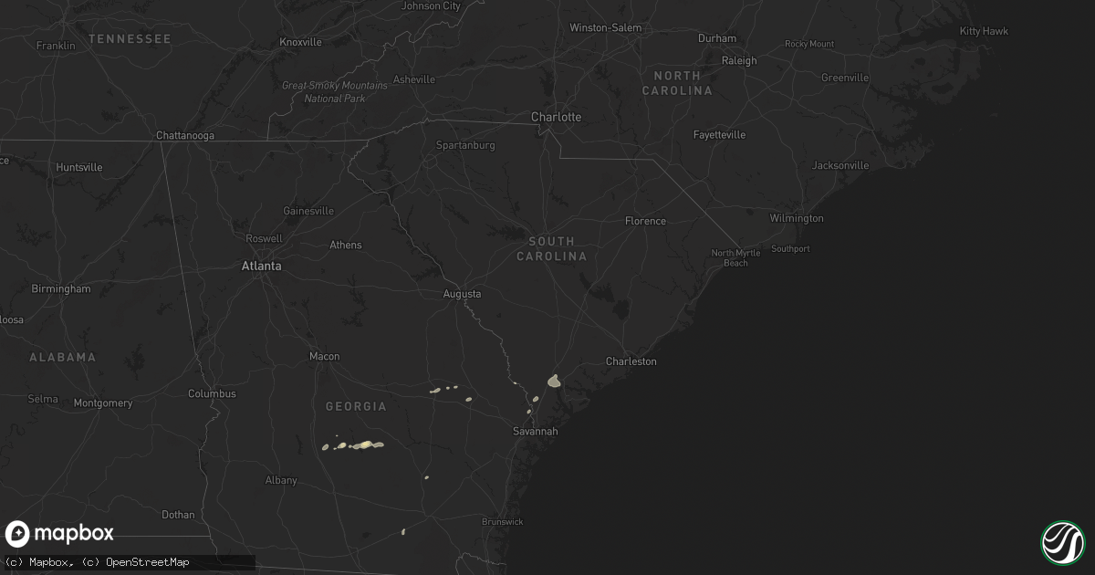
Hail Map in South Carolina on July 20, 2024
Get this storm
July 20 map
$229
one time, instant access
Download today. No call, no setup
Keep the $229
Bought the map and want the full workflow? Apply the entire $229 to a subscription within 7 days. None of it is wasted.
Every map, not just this one
This buys you this map. Subscription and you get every map we run, in the markets you choose from a few cities to whole states to nationwide. Plus real-time alerts the moment a storm fires.
Contact data
Name, contact info, occupancy, even credit band for addresses in the footprint. You go from where it hit to who to call.
Become the source they trust
Unlimited branding weather history reports on demand. You already have the documented answer ready for the property owner, and you are the one who showed up with it.
Property data and RoofTrace estimates
Pull up any address you have got, its value and the exact code rules for that jurisdiction, straight from One Click Code. Then RoofTrace estimates the squares, pitch, and roof value, priced the way you price.
Storm reports in South Carolina
South Carolina
| Date | Description |
|---|---|
| 07/20/20245:03 PM CDT | Tree down at 58 big rd. |
| 07/20/20244:55 PM CDT | Tree limb down on a power line on the 1900 block of trask parkway. The power line later started the tree on fire. |
| 07/20/20244:34 PM CDT | Tree down at 156 twickenham rd |
| 07/20/20244:30 PM CDT | Sc highway patrol reported a tree down on coosaw scenic drive. Time estimated by radar. |
| 07/20/20244:14 PM CDT | Two small trees down near the intersection of great swamp road and gensie shuman road. Time estimated based on radar. |
| 07/20/20243:18 PM CDT | Tree down at the intersection of hendersonville highway and combahee road. Time estimated by radar. |
| 07/20/20243:17 PM CDT | Sc highway patrol reported a tree down on stephanie circle. Time based on report. |
| 07/20/20242:53 PM CDT | Tree down on low country highway near state road s-15-28. Time estimated based on radar. |
| 07/20/20242:27 PM CDT | Tree down on lands end road. Time estimated by radar. |
All States Impacted by Hail Map on July 20, 2024
Cities Impacted by Hail Map on July 20, 2024
- Minatare, NE
- Scottsbluff, NE
- Swainsboro, GA
- Twin City, GA
- Cordele, GA
- Arabi, GA
- Edgemont, SD
- Harrison, NE
- Bayard, NE
- Pitts, GA
- Metter, GA
- Big Sandy, MT
- Hanover, NM
- Rochelle, GA
- Lusk, WY
- Circle, MT
- Freeport, TX
- Clute, TX
- Bridgeport, NE
- Abbeville, GA
- Register, GA
- Statesboro, GA
- Roseau, MN
- Rhine, GA
- Gail, TX
- Milan, GA
- Knott, TX
- Akron, CO
- Dunbar, WI
- Jacksonville, GA
- Martinsdale, MT
- Badger, MN
- Julesburg, CO
- Iron Mountain, MI
- Sagola, MI
- Felch, MI
- Fence, WI
- Cresbard, SD
- Clyo, GA
- McRae Helena, GA
- Cope, CO
- Anton, CO
- Vulcan, MI
- Ely, MN
- Homerville, GA
- Wrenshall, MN
- Argonne, WI
- Amherst, CO
- Watauga, SD
- Broadview, MT
- Lavina, MT
- Hunter, OK
- Enid, OK
- Lander, WY
- Bushnell, NE
- Barnum, MN
- Alma, GA
- Garber, OK
- Holyoke, CO
- Wray, CO
- Flagler, CO
- Kettle River, MN
- McIntosh, SD
- Skidmore, TX
- Laona, WI
- Crandon, WI
- Columbus, MT
- Adams, ND
- Bison, OK
- Lyman, NE
- Yoder, WY
- New Raymer, CO
- Arriba, CO
- Sterling, CO
- Yemassee, SC
- Ridgeland, SC
- Coosawhatchie, SC
- Sheldon, SC
- Green Cove Springs, FL
- Waukomis, OK
- Douglas, OK
- Fairmont, OK
- Jacksonville, FL
- Wabeno, WI
- Park City, MT
- Joliet, MT
- Willcox, AZ
- Merino, CO
- Fairdale, ND
- Brockton, MT
- Duluth, MN
- Tillman, SC
- Hennessey, OK
- Rincon, GA
- Beeville, TX
- Mathis, TX
- Hardeeville, SC
- Tamarack, MN
- Stoneham, CO
- Snyder, CO
- Fort Morgan, CO
- Hillrose, CO
- Lagrange, WY
- Hawk Springs, WY
- Newcastle, WY
- George West, TX
- Milton, ND
- Eagle Lake, FL
- Bartow, FL
- Winter Haven, FL
- Benson, AZ
- Weldona, CO
- Roberts, MT
- Fromberg, MT
- Edinburg, ND
- Aneta, ND
- Otis, CO
- Meriden, WY
- Cheyenne, WY
- Brush, CO
- Yuma, CO
- Burns, WY
- Albin, WY
- Bridger, MT
- Tynan, TX
- Hillsdale, WY
- Peridot, AZ
- Custer, SD
- Big Timber, MT
- Greycliff, MT
- Palatka, FL
- Goodland, KS
- Sonoita, AZ
- Carpenter, WY
- Pine, AZ
- Elgin, AZ
- Sedona, AZ
- Calumet, OK
- Grover, CO
- Wolf Point, MT
- Geary, OK
- Nunn, CO
- Vail, AZ
- Brocket, ND
- Webster, ND
- Leeds, ND
- Sharon, ND
- Lakota, ND
- Sharon Springs, KS
- Weskan, KS
- Menahga, MN
- Edmore, ND
- Wiggins, CO
- Tribune, KS
- Deer Trail, CO
- Woodrow, CO
- Limon, CO
- Agate, CO
- Hydro, OK
- Lookeba, OK
- Hinton, OK
- Byers, CO
- Onaka, SD
- Laporte, CO
- Fort Collins, CO
- Crary, ND
- Stratton, CO
- Kirk, CO
- Loveland, CO
- Berthoud, CO
- Longmont, CO
- Eagle Butte, SD
- Timnath, CO
- Arcadia, FL
- Edmond, OK
- La Salle, CO
- Platteville, CO
- Lawton, ND
- Sheyenne, ND
- Fort Lupton, CO
- Cando, ND
- Mead, CO
- Lafayette, CO
- Erie, CO
- Broomfield, CO
- Brighton, CO
- Hudson, CO
- Dacono, CO
- Frederick, CO
- Firestone, CO
- Denver, CO
- Pekin, ND
- Tolna, ND
- Park Rapids, MN
- Thornton, CO
- Henderson, CO
- Fort Meade, FL
- Esmond, ND
- Dupont, CO
- Commerce City, CO
- Aurora, CO
- Carnegie, OK
- Minnewaukan, ND
- Kingman, KS
- Johnstown, CO
- Windsor, CO
- Dupree, SD
- Denhoff, ND
- Wing, ND
- Drake, CO
- Hansboro, ND
- Goodrich, ND
- Fort Totten, ND
- Saint Michael, ND
- Fort Cobb, OK
- Lankin, ND
- Warwick, ND
- Bowdon, ND
- Glasgow, MT
- Harper, KS
- Rocklake, ND
- Oberon, ND
- Littleton, CO
- New Rockford, ND
- Guffey, CO
- Cathay, ND
- Fessenden, ND
- Grace City, ND
- Louviers, CO
- Saint Marie, MT
- Lyons, CO
- Kensal, ND
- Hurdsfield, ND
- Pingree, ND
- Kearny, AZ
- Lehr, ND
- Chaseley, ND
- Wishek, ND
- Buchanan, ND
- Tappen, ND
- Spivey, KS
- Streeter, ND
- Jamestown, ND
- Medina, ND
- Gackle, ND
- Seymour, TX
- Carrington, ND
- Napoleon, ND
- Dill City, OK
- Zeeland, ND
- Davidson, OK
- Blair, OK
- Altus, OK
- Altus Afb, OK


