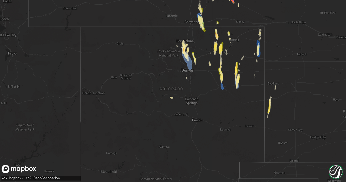
Hail Map in Colorado on July 20, 2024
Get this storm
July 20 map
$229
one time, instant access
Download today. No call, no setup
Keep the $229
Bought the map and want the full workflow? Apply the entire $229 to a subscription within 7 days. None of it is wasted.
Every map, not just this one
This buys you this map. Subscription and you get every map we run, in the markets you choose from a few cities to whole states to nationwide. Plus real-time alerts the moment a storm fires.
Contact data
Name, contact info, occupancy, even credit band for addresses in the footprint. You go from where it hit to who to call.
Become the source they trust
Unlimited branding weather history reports on demand. You already have the documented answer ready for the property owner, and you are the one who showed up with it.
Property data and RoofTrace estimates
Pull up any address you have got, its value and the exact code rules for that jurisdiction, straight from One Click Code. Then RoofTrace estimates the squares, pitch, and roof value, priced the way you price.
Storm reports in Colorado
Colorado
| Date | Description |
|---|---|
| 07/20/20246:45 PM CDT | Mesonet station dw1011 longmont. |
| 07/20/20246:20 PM CDT | A local report indicates 58 MPH wind near Fort Morgan |
| 07/20/20244:54 PM CDT | Weather underground site kcoflagl13. |
| 07/20/20244:52 PM CDT | Estimated 60-70 mph winds near ballyneal along with pea size hail that lasted for 2-3 minutes. Time was estimated via radar. |
| 07/20/20244:42 PM CDT | Mesonet station co048 us 385 holyoke. Also recorded a sustained wind of 57 mph. |
| 07/20/20244:35 PM CDT | Awos station kheq holyoke airport. |
| 07/19/202410:21 PM CDT | Tree down on a car. Photo via social media. Time estimated by radar. |
| 07/19/20249:58 PM CDT | Mesonet station co207 denver i-70/york st. |
| 07/19/20249:58 PM CDT | Mesonet station co003 denver i-70/colorado blvd. |
| 07/19/20249:34 PM CDT | A local report indicates 60 MPH wind near 2 SE Erie |
| 07/19/20249:27 PM CDT | Corrects previous non-tstm wnd gst report from 4 ese erie. Mesonet station co010 broomfield i-25/highway 7. |
| 07/19/20249:21 PM CDT | A local report indicates 65 MPH wind near Dacono |
| 07/19/20249:19 PM CDT | Report from mping: 1-inch tree limbs broken; shingles blown off. |
| 07/19/20249:16 PM CDT | Report from mping: 1-inch tree limbs broken; shingles blown off. |
| 07/19/20249:15 PM CDT | Delayed report. Time estimated by radar. |
| 07/19/20249:00 PM CDT | A local report indicates 1.00 inch wind near 2 SSW Berthoud |
| 07/19/20248:58 PM CDT | Report from mping: 1-inch tree limbs broken; shingles blown off. |
| 07/19/20248:53 PM CDT | A local report indicates 1.00 inch wind near 3 SSE Gilcrest |
| 07/19/20248:52 PM CDT | Delayed report. Time estimated by radar. |
| 07/19/20248:49 PM CDT | A local report indicates 64 MPH wind near 2 WSW Berthoud |
| 07/19/20248:48 PM CDT | A local report indicates 58 MPH wind near 4 WSW Berthoud |
| 07/19/20248:47 PM CDT | Mesonet station co037 i-25 berthoud. |
| 07/19/20248:45 PM CDT | Up to half dollar size hail fell for a duration of 6 minutes. |
| 07/19/20248:44 PM CDT | A local report indicates 1.50 inch wind near 1 NW Campion |
| 07/19/20248:40 PM CDT | A local report indicates 1.00 inch wind near 3 SW Loveland |
| 07/19/20248:34 PM CDT | A local report indicates 1.00 inch wind near 3 NW Campion |
| 07/19/20248:33 PM CDT | Asos station klic limon. |
| 07/19/20247:53 PM CDT | Between half inch to 1 inch diameter hail fell for 5 minutes. |
All States Impacted by Hail Map on July 20, 2024
Cities Impacted by Hail Map on July 20, 2024
- Minatare, NE
- Scottsbluff, NE
- Swainsboro, GA
- Twin City, GA
- Cordele, GA
- Arabi, GA
- Edgemont, SD
- Harrison, NE
- Bayard, NE
- Pitts, GA
- Metter, GA
- Big Sandy, MT
- Hanover, NM
- Rochelle, GA
- Lusk, WY
- Circle, MT
- Freeport, TX
- Clute, TX
- Bridgeport, NE
- Abbeville, GA
- Register, GA
- Statesboro, GA
- Roseau, MN
- Rhine, GA
- Gail, TX
- Milan, GA
- Knott, TX
- Akron, CO
- Dunbar, WI
- Jacksonville, GA
- Martinsdale, MT
- Badger, MN
- Julesburg, CO
- Iron Mountain, MI
- Sagola, MI
- Felch, MI
- Fence, WI
- Cresbard, SD
- Clyo, GA
- McRae Helena, GA
- Cope, CO
- Anton, CO
- Vulcan, MI
- Ely, MN
- Homerville, GA
- Wrenshall, MN
- Argonne, WI
- Amherst, CO
- Watauga, SD
- Broadview, MT
- Lavina, MT
- Hunter, OK
- Enid, OK
- Lander, WY
- Bushnell, NE
- Barnum, MN
- Alma, GA
- Garber, OK
- Holyoke, CO
- Wray, CO
- Flagler, CO
- Kettle River, MN
- McIntosh, SD
- Skidmore, TX
- Laona, WI
- Crandon, WI
- Columbus, MT
- Adams, ND
- Bison, OK
- Lyman, NE
- Yoder, WY
- New Raymer, CO
- Arriba, CO
- Sterling, CO
- Yemassee, SC
- Ridgeland, SC
- Coosawhatchie, SC
- Sheldon, SC
- Green Cove Springs, FL
- Waukomis, OK
- Douglas, OK
- Fairmont, OK
- Jacksonville, FL
- Wabeno, WI
- Park City, MT
- Joliet, MT
- Willcox, AZ
- Merino, CO
- Fairdale, ND
- Brockton, MT
- Duluth, MN
- Tillman, SC
- Hennessey, OK
- Rincon, GA
- Beeville, TX
- Mathis, TX
- Hardeeville, SC
- Tamarack, MN
- Stoneham, CO
- Snyder, CO
- Fort Morgan, CO
- Hillrose, CO
- Lagrange, WY
- Hawk Springs, WY
- Newcastle, WY
- George West, TX
- Milton, ND
- Eagle Lake, FL
- Bartow, FL
- Winter Haven, FL
- Benson, AZ
- Weldona, CO
- Roberts, MT
- Fromberg, MT
- Edinburg, ND
- Aneta, ND
- Otis, CO
- Meriden, WY
- Cheyenne, WY
- Brush, CO
- Yuma, CO
- Burns, WY
- Albin, WY
- Bridger, MT
- Tynan, TX
- Hillsdale, WY
- Peridot, AZ
- Custer, SD
- Big Timber, MT
- Greycliff, MT
- Palatka, FL
- Goodland, KS
- Sonoita, AZ
- Carpenter, WY
- Pine, AZ
- Elgin, AZ
- Sedona, AZ
- Calumet, OK
- Grover, CO
- Wolf Point, MT
- Geary, OK
- Nunn, CO
- Vail, AZ
- Brocket, ND
- Webster, ND
- Leeds, ND
- Sharon, ND
- Lakota, ND
- Sharon Springs, KS
- Weskan, KS
- Menahga, MN
- Edmore, ND
- Wiggins, CO
- Tribune, KS
- Deer Trail, CO
- Woodrow, CO
- Limon, CO
- Agate, CO
- Hydro, OK
- Lookeba, OK
- Hinton, OK
- Byers, CO
- Onaka, SD
- Laporte, CO
- Fort Collins, CO
- Crary, ND
- Stratton, CO
- Kirk, CO
- Loveland, CO
- Berthoud, CO
- Longmont, CO
- Eagle Butte, SD
- Timnath, CO
- Arcadia, FL
- Edmond, OK
- La Salle, CO
- Platteville, CO
- Lawton, ND
- Sheyenne, ND
- Fort Lupton, CO
- Cando, ND
- Mead, CO
- Lafayette, CO
- Erie, CO
- Broomfield, CO
- Brighton, CO
- Hudson, CO
- Dacono, CO
- Frederick, CO
- Firestone, CO
- Denver, CO
- Pekin, ND
- Tolna, ND
- Park Rapids, MN
- Thornton, CO
- Henderson, CO
- Fort Meade, FL
- Esmond, ND
- Dupont, CO
- Commerce City, CO
- Aurora, CO
- Carnegie, OK
- Minnewaukan, ND
- Kingman, KS
- Johnstown, CO
- Windsor, CO
- Dupree, SD
- Denhoff, ND
- Wing, ND
- Drake, CO
- Hansboro, ND
- Goodrich, ND
- Fort Totten, ND
- Saint Michael, ND
- Fort Cobb, OK
- Lankin, ND
- Warwick, ND
- Bowdon, ND
- Glasgow, MT
- Harper, KS
- Rocklake, ND
- Oberon, ND
- Littleton, CO
- New Rockford, ND
- Guffey, CO
- Cathay, ND
- Fessenden, ND
- Grace City, ND
- Louviers, CO
- Saint Marie, MT
- Lyons, CO
- Kensal, ND
- Hurdsfield, ND
- Pingree, ND
- Kearny, AZ
- Lehr, ND
- Chaseley, ND
- Wishek, ND
- Buchanan, ND
- Tappen, ND
- Spivey, KS
- Streeter, ND
- Jamestown, ND
- Medina, ND
- Gackle, ND
- Seymour, TX
- Carrington, ND
- Napoleon, ND
- Dill City, OK
- Zeeland, ND
- Davidson, OK
- Blair, OK
- Altus, OK
- Altus Afb, OK


