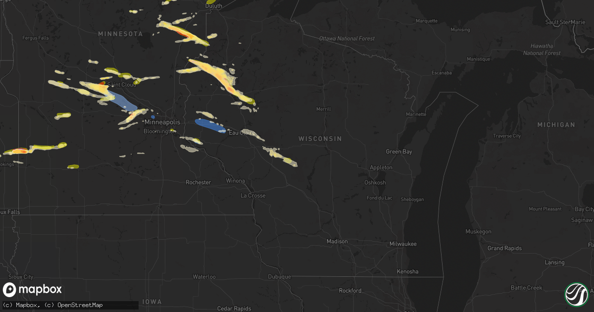
Hail Map in Wisconsin on July 19, 2023
Get this storm
July 19 map
$229
one time, instant access
Download today. No call, no setup
Keep the $229
Bought the map and want the full workflow? Apply the entire $229 to a subscription within 7 days. None of it is wasted.
Every map, not just this one
This buys you this map. Subscription and you get every map we run, in the markets you choose from a few cities to whole states to nationwide. Plus real-time alerts the moment a storm fires.
Contact data
Name, contact info, occupancy, even credit band for addresses in the footprint. You go from where it hit to who to call.
Become the source they trust
Unlimited branding weather history reports on demand. You already have the documented answer ready for the property owner, and you are the one who showed up with it.
Property data and RoofTrace estimates
Pull up any address you have got, its value and the exact code rules for that jurisdiction, straight from One Click Code. Then RoofTrace estimates the squares, pitch, and roof value, priced the way you price.
Storm reports in Wisconsin
Wisconsin
| Date | Description |
|---|---|
| 07/19/20236:54 PM CDT | A local report indicates 1.00 inch wind near 5 SW Weyerhaeuser |
| 07/19/20236:15 PM CDT | A local report indicates 1.75 inch wind near 2 SSW Rice Lake |
| 07/19/20236:12 PM CDT | Spotter also mentioned that power was lost shortly after the quarter sized hail fell. |
| 07/19/20236:11 PM CDT | Hail up to tennis ball size with hail breaking through a large retailers roof. |
| 07/19/20236:10 PM CDT | Ground covered with hail up to 2 inches in diameter with time estimated based on radar. |
| 07/19/20236:08 PM CDT | Lots of golf ball sized hail falling for the past few minutes. |
| 07/19/20236:08 PM CDT | Report via social media with photo. |
| 07/19/20236:00 PM CDT | 40 foot tall trees reported down on the north side of rice lake. |
| 07/19/20235:59 PM CDT | Hail damage includes severe damage to garden and trees. Possible damage to cars and roof. |
| 07/19/20235:57 PM CDT | Report via social media with photo. |
| 07/19/20235:50 PM CDT | Report from mping: half dollar |
| 07/19/20235:40 PM CDT | Time of report is estimated by a combination of radar and spotter report. |
| 07/19/20235:40 PM CDT | Spotter reports that several trees have been snapped. Some trees were snapped near the base while others were snapped near the top. The one tree that was snapped near t |
| 07/19/20235:35 PM CDT | Numerous tree branches were reported down with species being primarily white spruce and red pine. Branch size estimated to be around 2 inches in diameter. Time estimate |
| 07/19/20235:24 PM CDT | Report from mping: quarter |
| 07/19/20235:15 PM CDT | Report via social media with photo. |
| 07/19/20235:15 PM CDT | A local report indicates 1.25 inch wind near 4 SSE Webster |
| 07/19/20235:10 PM CDT | Report with photo of ground completely covered with hail. Largest hail stone estimated up to golf ball size. |
| 07/19/20235:10 PM CDT | Spotter reports that damage occurred to siding and window trim. Roof damage was also reported. Photos included in report showing the size of the hail compared to a quar |
| 07/19/20235:07 PM CDT | Report via social media with photo. |
| 07/19/20235:06 PM CDT | A local report indicates 1.25 inch wind near 4 SE Webster |
| 07/18/20238:31 PM CDT | A local report indicates 65 MPH wind near 6 W Gilman |
| 07/18/20238:30 PM CDT | Report from arx of spotter report on the chippewa and taylor county line. |
| 07/18/20238:10 PM CDT | Large tree limbs reported down in menomonie... Some of which were 8 inches in diameter. Menomonie awos... East of town... Measured 53 mph at 815 pm. |
| 07/18/20238:00 PM CDT | Time estimated based on radar. |
| 07/18/20238:00 PM CDT | Numerous large tree branches snapped around town. Some branches look to be at least 8 inches in diameter. |
| 07/18/20237:30 PM CDT | Scattered trees and power lines down across the southern half of st croix county. |
| 07/18/20237:03 PM CDT | Half dollar sized hail in the township of rusk with time estimated based on radar. |
All States Impacted by Hail Map on July 19, 2023
Cities Impacted by Hail Map on July 19, 2023
- Kiahsville, WV
- Harts, WV
- Dunlow, WV
- Ranger, WV
- Midkiff, WV
- Spurlockville, WV
- Alkol, WV
- Branchland, WV
- Griffithsville, WV
- Yawkey, WV
- Sumerco, WV
- Wilsondale, WV
- Fort Gay, WV
- Crum, WV
- Rocky Mount, NC
- Battleboro, NC
- Whitakers, NC
- Nashville, NC
- Wood, SD
- Presho, SD
- Draper, SD
- Fulton, KY
- Clinton, KY
- Arlington, KY
- Bardwell, KY
- Wickliffe, KY
- Cunningham, KY
- Sullivan, MO
- Cairo, IL
- Miller City, IL
- Federalsburg, MD
- Bridgeville, DE
- Thebes, IL
- Olive Branch, IL
- Scott City, MO
- Lonedell, MO
- McClure, IL
- Arlington, SD
- Bruce, SD
- Cohasset, MN
- Grand Rapids, MN
- Mcgregor, MN
- Tamarack, MN
- Crosby, MN
- Emily, MN
- Aitkin, MN
- White, SD
- Toronto, SD
- Astoria, SD
- Hendricks, MN
- Ivanhoe, MN
- Floodwood, MN
- Kelliher, MN
- Ponemah, MN
- Blackduck, MN
- Northome, MN
- Colorado Springs, CO
- Usaf Academy, CO
- Peyton, CO
- Max, MN
- Deer River, MN
- Talmoon, MN
- Spring Lake, MN
- Marcell, MN
- Bigfork, MN
- Calhan, CO
- Yoder, CO
- Rush, CO
- Minneota, MN
- Marshall, MN
- Sturgeon Lake, MN
- Bovey, MN
- Kettle River, MN
- Moose Lake, MN
- Grantsburg, WI
- Hinckley, MN
- Danbury, WI
- Webster, WI
- Chugwater, WY
- Siren, WI
- Hawk Springs, WY
- Kerrick, MN
- Bruno, MN
- Yoder, WY
- Veteran, WY
- Torrington, WY
- Starbuck, MN
- Glenwood, MN
- Paynesville, MN
- Freeport, MN
- Albany, MN
- Avon, MN
- Glendo, WY
- Cheyenne, WY
- Shell Lake, WI
- Frederic, WI
- Nashwauk, MN
- Melrose, MN
- Spooner, WI
- Hertel, WI
- Saint Martin, MN
- Richmond, MN
- Montevideo, MN
- Kerkhoven, MN
- Clara City, MN
- Maynard, MN
- Raymond, MN
- Murdock, MN
- Sandstone, MN
- Barronett, WI
- Bowlus, MN
- Holdingford, MN
- Royalton, MN
- Rice, MN
- Sartell, MN
- Sauk Rapids, MN
- Foley, MN
- Clear Lake, MN
- Princeton, MN
- Oak Park, MN
- Boone, CO
- Olney Springs, CO
- Ordway, CO
- Sugar City, CO
- Sarona, WI
- Cumberland, WI
- Ramah, CO
- Rice Lake, WI
- Brooten, MN
- Belgrade, MN
- Cold Spring, MN
- Watkins, MN
- Kimball, MN
- South Haven, MN
- Clearwater, MN
- Annandale, MN
- Hartville, WY
- Model, CO
- Roy, NM
- Gladstone, NM
- Grenville, NM
- Haugen, WI
- Buffalo, MN
- Montrose, MN
- Delano, MN
- Waverly, MN
- Howard Lake, MN
- Maple Lake, MN
- Eden Valley, MN
- Pengilly, MN
- Conchas Dam, NM
- Barron, WI
- Cameron, WI
- Morrill, NE
- Harrison, NE
- Hibbing, MN
- Lingle, WY
- Jay Em, WY
- Wheatland, WY
- Guernsey, WY
- Goodland, MN
- Chadron, NE
- Nashua, MN
- Kadoka, SD
- Midland, SD
- Fort Pierre, SD
- Okaton, SD
- Warner, SD
- Bluffton, MN
- Sebeka, MN
- Pine River, MN
- Pierpont, SD
- Wadena, MN
- Highmore, SD
- New Effington, SD
- New York Mills, MN
- Sisseton, SD
- Blunt, SD
- Holabird, SD
- Staples, MN
- Wanblee, SD
- Stratford, SD
- Andover, SD
- Fairmount, ND
- Dalton, MN
- Rosholt, SD
- Pierre, SD
- Underwood, MN
- Remer, MN
- Northville, SD
- Rockham, SD
- Porcupine, SD
- Roslyn, SD
- Mellette, SD
- Cresbard, SD
- Longville, MN
- Orient, SD
- Backus, MN
- Harrold, SD
- Crawford, NE
- Manderson, SD
- Kyle, SD
- Belvidere, SD
- Campbell, MN
- Conde, SD
- Groton, SD
- Eden, SD
- Tintah, MN
- Pine Ridge, SD
- Ottertail, MN
- Fergus Falls, MN
- Faulkton, SD
- Lake City, SD
- Henning, MN
- Battle Lake, MN
- Saint Michael, MN
- Hanover, MN
- Rogers, MN
- Minneapolis, MN
- Osseo, MN
- Maple Grove, MN
- Stratton, NE
- Trenton, NE
- Atwood, KS
- Brewster, KS
- Levant, KS
- Colby, KS
- Cyrus, MN
- Hancock, MN
- Morris, MN
- Carlton, MN
- Jacobson, MN
- Milaca, MN
- Herndon, KS
- Trementina, NM
- Montello, NV
- Ideal, GA
- Oglethorpe, GA
- Palisade, MN
- Mitchell, SD
- Fulton, SD
- Lake Benton, MN
- Elkton, SD
- Fremont, NC
- De Smet, SD
- Long Prairie, MN
- Swanville, MN
- Burtrum, MN
- Grey Eagle, MN
- Isle, MN
- McGrath, MN
- Milledgeville, GA
- Eatonton, GA
- Lagrange, GA
- Lanett, AL
- Squaw Lake, MN
- Echo, MN
- Wood Lake, MN
- Barnum, MN
- Hamill, SD
- Kennebec, SD
- Ideal, SD
- Winner, SD
- Ghent, MN
- Porter, MN
- Taunton, MN
- Cottonwood, MN
- Limon, CO
- Bonaire, GA
- Dry Branch, GA
- Kathleen, GA
- Warner Robins, GA
- Jeffersonville, GA
- Wessington Springs, SD
- Roscoe, MN
- Ocala, FL
- Cromwell, MN
- Ellaville, GA
- Raton, NM
- Des Moines, NM
- East Prairie, MO
- Americus, GA
- Lowry, MN
- Danville, GA
- Irwinton, GA
- Virgil, SD
- Wessington, SD
- Cusseta, AL
- Valley, AL
- Windsor, NC
- Sauk Centre, MN
- Elrosa, MN
- Belview, MN
- Brookings, SD
- Alpena, SD
- Winter Park, FL
- Stedman, NC
- Fayetteville, NC
- Folsom, NM
- Five Points, AL
- Garrison, UT
- New London, MN
- Plains, GA
- Woonsocket, SD
- Winter Springs, FL
- Casselberry, FL
- Hawkinsville, GA
- Orlando, FL
- Farwell, MN
- Saint Joseph, MN
- Tampa, FL
- Matheson, CO
- Mitchell, NE
- Fort Laramie, WY
- Chetek, WI
- Kim, CO
- Ludell, KS
- Edson, KS
- Bird City, KS
- McDonald, KS
- Mosquero, NM
- Weyerhaeuser, WI
- Tooele, UT
- New Auburn, WI
- Bruce, WI
- Oberlin, KS
- Duluth, MN
- Holcombe, WI
- Hammond, WI
- Baldwin, WI
- Wilson, WI
- Woodville, WI
- Roberts, WI
- Glenwood City, WI
- Menomonie, WI
- Knapp, WI
- Spring Valley, WI
- Inver Grove Heights, MN
- Saint Paul Park, MN
- South Saint Paul, MN
- Lamberton, MN
- Sanborn, MN
- Springfield, MN
- Ellsworth, WI
- Hager City, WI
- Saint Stephen, MN
- Alliance, NE
- Richlands, NC
- Campo, CO
- Grinnell, KS
- Stuart, NE
- Oneill, NE
- Prescott, WI
- Crofton, NE
- Fordyce, NE
- Park, KS
- Hoxie, KS
- Quinter, KS
- Oakley, KS
- Dalbo, MN
- Stanchfield, MN
- Welch, MN
- Revere, MN
- Hines, MN
- Pine City, MN
- Scotland, SD
- Selden, KS
- Watertown, MN
- Spencer, NE
- Lynch, NE
- Hastings, MN
- Cannon Falls, MN
- Gem, KS
- La Junta, CO
- Bloomer, WI
- Cornell, WI
- Park Valley, UT
- Garita, NM
- Rush City, MN
- Willow River, MN
- Birchwood, WI
- New Richmond, WI
- Clayton, NM
- Hawthorne, NV
- Cloquet, MN
- Kite, GA
- Swainsboro, GA
- Askov, MN
- Sheridan Lake, CO
- Mikana, WI
- Kenton, OK
- Pritchett, CO
- Fowler, CO
- Niobrara, NE
- Bloomfield, NE
- New Prague, MN
- Las Animas, CO
- Foxboro, WI
- Garfield, GA
- Twin City, GA
- Midville, GA
- Dresden, KS
- Merna, NE
- Anselmo, NE
- Millen, GA
- Dana, IA
- Yankton, SD
- Tabor, SD
- Saint Helena, NE
- Tyndall, SD
- Cottage Grove, MN
- Finlayson, MN
- Walsenburg, CO
- Hampton, MN
- Winsted, MN
- Rockford, MN
- Center, NE
- Verdigre, NE
- Sahuarita, AZ
- Green Valley, AZ
- Emigsville, PA
- Dover, PA
- York, PA
- Red Lion, PA
- Silver Lake, MN
- Lester Prairie, MN
- Glencoe, MN
- Mayer, MN
- New Germany, MN
- Sylvania, GA
- Bay City, WI
- Hamel, MN
- Loretto, MN
- Lesterville, SD
- Gabbs, NV
- Saint Cloud, MN
- Rexford, KS
- Jennings, KS
- Kensington, MN
- Litchfield, MN
- Portal, GA
- Grove City, MN
- Dalton, NE
- Bayard, NE
- Cokato, MN
- Dallas, WI
- Saint Peter, MN
- Le Sueur, MN
- Pittsville, WI
- Dodge City, KS
- Wright, KS
- Ford, KS
- Bucklin, KS
- Greensburg, KS
- Mullinville, KS
- Gove, KS
- Baudette, MN
- Littlefork, MN
- Mountain Iron, MN
- Chisholm, MN
- Kinney, MN
- Buhl, MN
- Jim Falls, WI
- Canon City, CO
- Guffey, CO
- Calumet, MN
- Ingalls, KS
- Freedom, OK
- Fall Creek, WI
- Downing, WI
- Montezuma, KS
- Copeland, KS
- Maiden Rock, WI
- Neillsville, WI
- Fairchild, WI
- Humbird, WI
- Black River Falls, WI
- Merrillan, WI
- Virginia, MN
- Loman, MN
- Red Wing, MN
- Garden City, KS
- Pratt, KS
- Cimarron, KS
- Haviland, KS
- Solon Springs, WI
- Ellis, KS
- Le Center, MN
- Iuka, KS
- Follett, TX
- Syracuse, KS
- Augusta, WI
- Ogallah, KS
- Turon, KS
- Stafford, KS
- Elk Mound, WI
- Kendall, KS
- Altoona, WI
- Eau Claire, WI
- Chippewa Falls, WI
- Cadott, WI
- Long Lake, MN
- Boyceville, WI
- Winona, KS
- Minneola, KS
- Ensign, KS
- Richfield, KS
- Eden Prairie, MN
- Maple Plain, MN
- Kincaid, KS
- Colony, KS
- Canadian, TX
- Burlington, KS
- Westphalia, KS
- Bronson, KS
- Wellington, KS
- Oxford, KS
- Belle Plaine, KS
- Winfield, KS
- Pleasanton, KS
- Phillipsburg, MO
- Long Lane, MO
- Babcock, WI
- Bolivar, MO
- Half Way, MO
- Polk, MO
- Iola, KS
- Blue Mound, KS
- Welda, KS
- Garnett, KS
- La Harpe, KS
- Moran, KS
- Camdenton, MO
- Buffalo, MO
- Carthage, TN
- Gainesboro, TN
- Pleasant Shade, TN
- Centerville, KS
- Parker, KS
- Mound City, KS
- El Dorado Springs, MO
- Walker, MO
- Collins, MO
- Mapleton, KS
- Humansville, MO
- Ashland, KS
- Westmoreland, TN
- Morrisville, MO
- Aldrich, MO
- Nevada, MO
- Englewood, KS
- Fargo, OK
- Neosho Falls, KS
- Le Roy, KS
- Shattuck, OK
- Flemington, MO
- Dunnegan, MO
- Quincy, MO
- Osceola, MO
- Rockville, MO
- Appleton City, MO
- Elkland, MO
- Amoret, MO
- Amsterdam, MO
- Roach, MO
- Weaubleau, MO
- Butler, MO
- Lebanon, MO
- Macks Creek, MO


