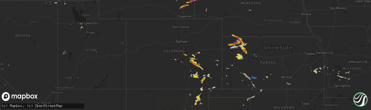
Hail Map on July 19, 2023
The weather event on July 19, 2023 includes Wind, Tornado, and Hail maps. 27 states and 569 cities were impacted and suffered possible damage. The total estimated number of properties impacted is 79,158.
Want more than just the map?
Turn this storm into a full workflow.
- Owner + property data so you know who to knock
- OnDemand branded weather history reports to win the "did we even have hail?" argument
- RoofTrace estimate so reps stop guessing numbers at the door
Bought this map? Upgrade within 7 days and we'll credit the $230. (10-15 min setup call)
Wind
Tornado
Hail
79,158
Estimated number of impacted properties by a 1.00" hail or larger19,464
Estimated number of impacted properties by a 1.75" hail or larger6,737
Estimated number of impacted properties by a 2.50" hail or largerStates Impacted by Hail Map on July 19, 2023
Storm reports
New Mexico
| Date | Description |
|---|---|
| 07/19/20234:57 PM CDT | Also with some pea size hail. |
Georgia
| Date | Description |
|---|---|
| 07/19/20236:46 PM CDT | A 911 call center reported a tree down along dorsey clark rd. Time was estimated via radar data. |
| 07/19/20236:22 PM CDT | A 911 call center reported a tree down along old ogeechee rd. Time was estimated via radar data. |
Colorado
| Date | Description |
|---|---|
| 07/19/20234:01 PM CDT | Largest hail stone was 1.1 inches. Time is estimated. |
| 07/19/20233:25 PM CDT | Report received via media. |
South Carolina
| Date | Description |
|---|---|
| 07/19/20236:55 PM CDT | A 911 call center reported several trees down outside the towns of hampton and varnville due to thunderstorm outflow. |
| 07/19/20236:43 PM CDT | A 911 call center reported a tree down at the intersection of augusta stage coach and shirley rd. Time was estimated via radar. |
| 07/19/20235:06 PM CDT | Approximately 40 pieces of vinyl siding stripped off the side of a chimney. |
| 07/19/20234:05 PM CDT | 3 trees down on us 321 between fairfax and luray. |
| 07/19/20234:05 PM CDT | One tree reported down near broxton bridge plantation. |
| 07/19/20233:57 PM CDT | Tree down blocking road near the intersection of barton road and lakey drive. |
| 07/19/20233:49 PM CDT | Tree down blocking road near the intersection of fitts and bluff road. |
| 07/19/20233:35 PM CDT | Allendale awos gusted to 58 mph. |
Kansas
| Date | Description |
|---|---|
| 07/19/20236:29 PM CDT | Awos station kcbk 2 n colby. |
| 07/19/20236:25 PM CDT | Public report of 12 power poles snapped off near road 9 and road s northwest of levant. Also a big blue spruce tree was uprooted. Time estimated. |
| 07/19/20236:11 PM CDT | Reports received of 4 semis overturned on i-70 around mm 35 near brewster. |
| 07/19/20236:05 PM CDT | Trained spotter reports winds estimated in excess of 60 mph. |
| 07/19/20236:05 PM CDT | Trained spotter reports live trees down... Fences down... And shingles off of houses in brewster. |
| 07/19/20235:25 PM CDT | Off duty nws employee reports large tree limb down. Time estimated. |
| 07/18/20237:45 PM CDT | Trained spotter reports hail up to quarter size with photo sent via social media. |
| 07/18/20237:41 PM CDT | Spotter reports quarter size hail... Covering hwy 25 near mm 215. |
| 07/18/20237:04 PM CDT | A local report indicates 60 MPH wind near Selden |
| 07/18/20237:02 PM CDT | Law enforcement reports hail up to quarter size or larger in selden. Time estimated from radar. |
Minnesota
| Date | Description |
|---|---|
| 07/19/20236:55 PM CDT | Late lsr - trained spotter reported downed tree blocking roadway in willernie... Mn. Time estimated via radar. |
| 07/19/20236:55 PM CDT | Late lsr - trained spotter reported large tree branches and tree down near wedgewood park. Photos were provided via email. Time estimated via radar. |
| 07/19/20236:45 PM CDT | Asos station kmic crystal ap. |
| 07/19/20236:33 PM CDT | Also measured 62 mph at 630 pm. |
| 07/19/20236:15 PM CDT | Small 5 inch diameter tree down blown down facing west. Time estimated by radar. |
| 07/19/20236:12 PM CDT | Report from mping: quarter |
| 07/19/20236:10 PM CDT | Several 8 to 10 inch diameter aspen trees down pointing from northwest and southeast. Time estimated from radar. |
| 07/19/20236:09 PM CDT | Report of a tightly rotating mesocyclone and possible wind or tornado damage on highway 169 approximately 2 miles east of calumet. Location approximate. Time estimated |
| 07/19/20236:09 PM CDT | Quarter size hail. Location approximate. Time estimated by radar. |
| 07/19/20236:04 PM CDT | Late lsr - emergency manager emailed photo of large tree that fell on unoccupied vehicle in atwater... Mn and additionally reported other areas within the city of atwat |
| 07/19/20236:00 PM CDT | A local report indicates 1.75 inch wind near Waverly |
| 07/19/20235:33 PM CDT | A local report indicates 1.00 inch wind near 12 N Grand Rapids |
| 07/19/20235:26 PM CDT | Six to eight inch tree branches down with time estimated based on radar. |
| 07/19/20235:20 PM CDT | Report from social media with photo. |
| 07/19/20235:15 PM CDT | Relayed via stearns county em. |
| 07/19/20235:05 PM CDT | A local report indicates 1.50 inch wind near Bruno |
| 07/19/20234:53 PM CDT | Report via broadcast meteorologist viewer with photo. Time estimated from radar. |
| 07/19/20234:52 PM CDT | A local report indicates 1.00 inch wind near 3 E Sturgeon Lake |
| 07/19/20234:51 PM CDT | A local report indicates 1.00 inch wind near 1 ENE Sturgeon Lake |
| 07/19/20234:48 PM CDT | A local report indicates 1.50 inch wind near 3 S Albany |
| 07/19/20234:47 PM CDT | Photo via social media with measuring tape. Time estimated from radar. |
| 07/19/20234:47 PM CDT | A local report indicates 1.75 inch wind near 5 S Albany |
| 07/19/20234:35 PM CDT | Photo was taken of quarter sized hail and was reported to be slightly larger than a quarter. |
| 07/19/20234:25 PM CDT | Numerous 3 to 4 inch diameter branches down... Generally 5 to 10 feet long. |
| 07/19/20234:25 PM CDT | Hail melted quickly but some piles were still around as of 445 pm. |
| 07/19/20234:15 PM CDT | Report from mping: quarter |
| 07/19/20234:15 PM CDT | Report via social media with video. Observer reports they have broken windows and a dented car. Time estimated from radar. |
| 07/19/20234:10 PM CDT | Report from social media of numerous 2 to 2.5 inch diameter hailstones with measuring tape photo. |
| 07/19/20234:05 PM CDT | Report via social media with photo. Time estimated from radar. |
| 07/19/20234:03 PM CDT | Social media report. |
| 07/19/20233:50 PM CDT | Spotter reports dime to quarter sized hail. |
| 07/19/20233:37 PM CDT | Lots of damage to vehicle due to large hail. |
| 07/19/20233:30 PM CDT | Social media picture. |
| 07/19/20233:28 PM CDT | Social media picture. |
| 07/19/20233:26 PM CDT | A local report indicates 1.00 inch wind near 4 W Kelliher |
| 07/19/20233:24 PM CDT | Social media picture. |
| 07/19/20233:23 PM CDT | Hail varied from pea size to golf ball size. |
| 07/19/20233:15 PM CDT | Size estimated from pictures. Time estimated from radar. |
| 07/19/20233:13 PM CDT | A local report indicates 1.00 inch wind near Saum |
| 07/19/20233:08 PM CDT | Quarter size hail report from mping. |
| 07/19/20233:02 PM CDT | Half dollar sized hail reported by the public 5 sw baudette. |
| 07/19/20232:55 PM CDT | Hailstone was measured next to a quarter. Spotter notes that the hail was slightly larger than the quarter. |
| 07/18/20237:52 PM CDT | A local report indicates 1.00 inch wind near Inver Grove Height |
| 07/18/20237:32 PM CDT | Late lsr - large tree branches down. Time estimated via radar. |
| 07/18/20237:29 PM CDT | Late lsr - large tree down near the intersection of peony ln and old rockford rd. Photo shared via social media. Time estimated via radar. |
| 07/18/20237:15 PM CDT | Report sent in via social media. |
| 07/18/20237:00 PM CDT | Numerous hailstones with the largest stones up to quarter size. |
| 07/18/20237:00 PM CDT | Spotter reports nickel to quarter sized hail. |
North Carolina
| Date | Description |
|---|---|
| 07/19/20236:04 PM CDT | Tree down on powerline and blocking huffmantown rd near cox rd. |
| 07/19/20235:19 PM CDT | Trees down near the intersection of rock hill road and dunn road. Time estimated by radar. |
| 07/19/20234:58 PM CDT | Trees down near the intersection of hayfield road and s river school road. Time estimated by radar. |
| 07/19/20234:14 PM CDT | A portion of a roof was blown off at a residence along the 500 block of ocean trail. Debris from the roof traveled and hit a nearby transformer. Time estimated from rad |
| 07/19/20231:45 PM CDT | Tree and powerline down near the intersection of alex benton road and friday road. Time estimated by radar. |
| 07/19/202311:43 AM CDT | Confirmed tornado touchdown. Storm survey will be conducted this afternoon. |
| 07/19/202311:37 AM CDT | Confirmed tornado touchdown. Storm survey will be conducted this afternoon. |
Illinois
| Date | Description |
|---|---|
| 07/19/20237:01 AM CDT | Tree over road. |
Florida
| Date | Description |
|---|---|
| 07/19/20234:00 PM CDT | A large oak tree was snapped at the trunk and fell across sw 153rd place road. It blocked the entrance to the marion oaks neighborhood. Photos were relayed by the media |
South Dakota
| Date | Description |
|---|---|
| 07/19/20233:15 PM CDT | Social media picture. |
| 07/19/20232:50 PM CDT | Mping report of quarter size hail. |
Pennsylvania
| Date | Description |
|---|---|
| 07/18/20237:45 PM CDT | Trees on wires. |
| 07/18/20237:45 PM CDT | Damage to chimney and roof. |
| 07/18/20237:35 PM CDT | Widespread trees down across the city. |
Wisconsin
| Date | Description |
|---|---|
| 07/19/20236:54 PM CDT | A local report indicates 1.00 inch wind near 5 SW Weyerhaeuser |
| 07/19/20236:15 PM CDT | A local report indicates 1.75 inch wind near 2 SSW Rice Lake |
| 07/19/20236:12 PM CDT | Spotter also mentioned that power was lost shortly after the quarter sized hail fell. |
| 07/19/20236:11 PM CDT | Hail up to tennis ball size with hail breaking through a large retailers roof. |
| 07/19/20236:10 PM CDT | Ground covered with hail up to 2 inches in diameter with time estimated based on radar. |
| 07/19/20236:08 PM CDT | Report via social media with photo. |
| 07/19/20236:08 PM CDT | Lots of golf ball sized hail falling for the past few minutes. |
| 07/19/20236:00 PM CDT | 40 foot tall trees reported down on the north side of rice lake. |
| 07/19/20235:59 PM CDT | Hail damage includes severe damage to garden and trees. Possible damage to cars and roof. |
| 07/19/20235:57 PM CDT | Report via social media with photo. |
| 07/19/20235:50 PM CDT | Report from mping: half dollar |
| 07/19/20235:40 PM CDT | Time of report is estimated by a combination of radar and spotter report. |
| 07/19/20235:40 PM CDT | Spotter reports that several trees have been snapped. Some trees were snapped near the base while others were snapped near the top. The one tree that was snapped near t |
| 07/19/20235:35 PM CDT | Numerous tree branches were reported down with species being primarily white spruce and red pine. Branch size estimated to be around 2 inches in diameter. Time estimate |
| 07/19/20235:24 PM CDT | Report from mping: quarter |
| 07/19/20235:15 PM CDT | A local report indicates 1.25 inch wind near 4 SSE Webster |
| 07/19/20235:15 PM CDT | Report via social media with photo. |
| 07/19/20235:10 PM CDT | Spotter reports that damage occurred to siding and window trim. Roof damage was also reported. Photos included in report showing the size of the hail compared to a quar |
| 07/19/20235:10 PM CDT | Report with photo of ground completely covered with hail. Largest hail stone estimated up to golf ball size. |
| 07/19/20235:07 PM CDT | Report via social media with photo. |
| 07/19/20235:06 PM CDT | A local report indicates 1.25 inch wind near 4 SE Webster |
| 07/18/20238:31 PM CDT | A local report indicates 65 MPH wind near 6 W Gilman |
| 07/18/20238:30 PM CDT | Report from arx of spotter report on the chippewa and taylor county line. |
| 07/18/20238:10 PM CDT | Large tree limbs reported down in menomonie... Some of which were 8 inches in diameter. Menomonie awos... East of town... Measured 53 mph at 815 pm. |
| 07/18/20238:00 PM CDT | Numerous large tree branches snapped around town. Some branches look to be at least 8 inches in diameter. |
| 07/18/20238:00 PM CDT | Time estimated based on radar. |
| 07/18/20237:30 PM CDT | Scattered trees and power lines down across the southern half of st croix county. |
| 07/18/20237:03 PM CDT | Half dollar sized hail in the township of rusk with time estimated based on radar. |
Tennessee
| Date | Description |
|---|---|
| 07/19/202310:45 AM CDT | 30 to 40 trees reportedly blown down across southern lawrence county from westpoint road to the giles county line. |
Wyoming
| Date | Description |
|---|---|
| 07/19/20235:30 PM CDT | Lasted about 5 minutes. |
| 07/19/20235:27 PM CDT | A local report indicates 1.25 inch wind near Glendo |
| 07/19/20235:27 PM CDT | Report from mping of hen egg size hail. |
| 07/19/20235:26 PM CDT | Report from mping: golf ball |
| 07/19/20235:25 PM CDT | Golf ball sized hail reported at resturant 3s of torrington. Car windows broken. |
| 07/19/20235:16 PM CDT | A local report indicates 2.50 inch wind near 3 ENE Veteran |
| 07/19/20235:14 PM CDT | A local report indicates 1.00 inch wind near 3 ENE Veteran |
| 07/19/20235:10 PM CDT | Received report via facebook. |
| 07/19/20235:00 PM CDT | Initially ping pong ball size hail then mostly dime size. |
| 07/19/20234:32 PM CDT | Facebook photo shows hail stone and quarter. |
| 07/19/20234:00 PM CDT | Received report of windows shattered on homes and vehicles south of chugwater. Time estimated based on radar. |
Kentucky
| Date | Description |
|---|---|
| 07/19/20237:10 AM CDT | Trees over the road and water. |
Utah
| Date | Description |
|---|---|
| 07/19/20236:56 PM CDT | Corrects previous non-tstm wnd gst report from 5 ne lake pt. Mesonet station as768 great salt lake marina. |
| 07/19/20236:44 PM CDT | A local report indicates 1.25 inch wind near Tooele |
| 07/19/20236:32 PM CDT | Broadcast media shared photo of large hail stones. Largest estimated is the size of a ping pong ball. Time estimated from radar. |
| 07/19/20236:26 PM CDT | A local report indicates 1.00 inch wind near Tooele |
| 07/19/20236:20 PM CDT | Mesonet station dpg06 camel back mtn. |
| 07/19/20236:10 PM CDT | Mesonet station utsto sr-36 at mp 49 stockton bar. |
| 07/19/20236:00 PM CDT | Mesonet station dpg21 simpson spring. |
| 07/18/20238:33 PM CDT | Asos station kogd ogden-hinckley airport. |
| 07/18/20238:33 PM CDT | Corrects previous non-tstm wnd gst report from hill afb. Awos station khif hill air force base. |
| 07/18/20238:20 PM CDT | Corrects previous non-tstm wnd gst report from 3 ne sundance. Mesonet station utdcd us-189 at deer creek dam. |
| 07/18/20238:18 PM CDT | *** 1 fatal *** a 40-50 ft tall tree along the denver and rio grande western rail trail fell on a bicyclist. |
| 07/18/20238:16 PM CDT | Mesonet station uupya uofu playa research site. |
| 07/18/20238:10 PM CDT | Mesonet station snd arrowhead summit. |
| 07/18/20238:00 PM CDT | Mesonet station snd arrowhead summit. |
| 07/18/20238:00 PM CDT | Mesonet station pc034 provo canyon. |
| 07/18/20237:50 PM CDT | Mesonet station ut201 sr-201 at i-80. |
| 07/18/20237:45 PM CDT | Mesonet station kcc02 marina. |
| 07/18/20237:20 PM CDT | Mesonet station pc104 grantsville south. |
Nebraska
| Date | Description |
|---|---|
| 07/19/20236:45 PM CDT | A local report indicates 1.00 inch wind near 6 N Morrill |
| 07/19/20236:45 PM CDT | Photo shows ground covered in ping pong to golfball hail stones. |
| 07/19/20236:07 PM CDT | Trained spotter report of nickel to dime size hail. Time estimated from radar. |
| 07/19/20236:05 PM CDT | A local report indicates 2.50 inch wind near 7 NNE Henry |
| 07/19/20236:01 PM CDT | A local report indicates 2.00 inch wind near 7 NNE Henry |
| 07/19/20235:45 PM CDT | Corrects previous hail report from 5 n henry. Photo shows ground covered in ping pong to golf ball hail stones. |
| 07/18/20237:15 PM CDT | Mping report. |
| 07/18/20237:02 PM CDT | Estimated due to hail ongoing. |
Cities Impacted by Hail Map on July 19, 2023
- Kiahsville, WV
- Harts, WV
- Dunlow, WV
- Ranger, WV
- Midkiff, WV
- Spurlockville, WV
- Alkol, WV
- Branchland, WV
- Griffithsville, WV
- Yawkey, WV
- Sumerco, WV
- Wilsondale, WV
- Fort Gay, WV
- Crum, WV
- Rocky Mount, NC
- Battleboro, NC
- Whitakers, NC
- Nashville, NC
- Wood, SD
- Presho, SD
- Draper, SD
- Fulton, KY
- Clinton, KY
- Arlington, KY
- Bardwell, KY
- Wickliffe, KY
- Cunningham, KY
- Sullivan, MO
- Cairo, IL
- Miller City, IL
- Federalsburg, MD
- Bridgeville, DE
- Thebes, IL
- Olive Branch, IL
- Scott City, MO
- Lonedell, MO
- McClure, IL
- Arlington, SD
- Bruce, SD
- Cohasset, MN
- Grand Rapids, MN
- Mcgregor, MN
- Tamarack, MN
- Crosby, MN
- Emily, MN
- Aitkin, MN
- White, SD
- Toronto, SD
- Astoria, SD
- Hendricks, MN
- Ivanhoe, MN
- Floodwood, MN
- Kelliher, MN
- Ponemah, MN
- Blackduck, MN
- Northome, MN
- Colorado Springs, CO
- Usaf Academy, CO
- Peyton, CO
- Max, MN
- Deer River, MN
- Talmoon, MN
- Spring Lake, MN
- Marcell, MN
- Bigfork, MN
- Calhan, CO
- Yoder, CO
- Rush, CO
- Minneota, MN
- Marshall, MN
- Sturgeon Lake, MN
- Bovey, MN
- Kettle River, MN
- Moose Lake, MN
- Grantsburg, WI
- Hinckley, MN
- Danbury, WI
- Webster, WI
- Chugwater, WY
- Siren, WI
- Hawk Springs, WY
- Kerrick, MN
- Bruno, MN
- Yoder, WY
- Veteran, WY
- Torrington, WY
- Starbuck, MN
- Glenwood, MN
- Paynesville, MN
- Freeport, MN
- Albany, MN
- Avon, MN
- Glendo, WY
- Cheyenne, WY
- Shell Lake, WI
- Frederic, WI
- Nashwauk, MN
- Melrose, MN
- Spooner, WI
- Hertel, WI
- Saint Martin, MN
- Richmond, MN
- Montevideo, MN
- Kerkhoven, MN
- Clara City, MN
- Maynard, MN
- Raymond, MN
- Murdock, MN
- Sandstone, MN
- Barronett, WI
- Bowlus, MN
- Holdingford, MN
- Royalton, MN
- Rice, MN
- Sartell, MN
- Sauk Rapids, MN
- Foley, MN
- Clear Lake, MN
- Princeton, MN
- Oak Park, MN
- Boone, CO
- Olney Springs, CO
- Ordway, CO
- Sugar City, CO
- Sarona, WI
- Cumberland, WI
- Ramah, CO
- Rice Lake, WI
- Brooten, MN
- Belgrade, MN
- Cold Spring, MN
- Watkins, MN
- Kimball, MN
- South Haven, MN
- Clearwater, MN
- Annandale, MN
- Hartville, WY
- Model, CO
- Roy, NM
- Gladstone, NM
- Grenville, NM
- Haugen, WI
- Buffalo, MN
- Montrose, MN
- Delano, MN
- Waverly, MN
- Howard Lake, MN
- Maple Lake, MN
- Eden Valley, MN
- Pengilly, MN
- Conchas Dam, NM
- Barron, WI
- Cameron, WI
- Morrill, NE
- Harrison, NE
- Hibbing, MN
- Lingle, WY
- Jay Em, WY
- Wheatland, WY
- Guernsey, WY
- Goodland, MN
- Chadron, NE
- Nashua, MN
- Kadoka, SD
- Midland, SD
- Fort Pierre, SD
- Okaton, SD
- Warner, SD
- Bluffton, MN
- Sebeka, MN
- Pine River, MN
- Pierpont, SD
- Wadena, MN
- Highmore, SD
- New Effington, SD
- New York Mills, MN
- Sisseton, SD
- Blunt, SD
- Holabird, SD
- Staples, MN
- Wanblee, SD
- Stratford, SD
- Andover, SD
- Fairmount, ND
- Dalton, MN
- Rosholt, SD
- Pierre, SD
- Underwood, MN
- Remer, MN
- Northville, SD
- Rockham, SD
- Porcupine, SD
- Roslyn, SD
- Mellette, SD
- Cresbard, SD
- Longville, MN
- Orient, SD
- Backus, MN
- Harrold, SD
- Crawford, NE
- Manderson, SD
- Kyle, SD
- Belvidere, SD
- Campbell, MN
- Conde, SD
- Groton, SD
- Eden, SD
- Tintah, MN
- Pine Ridge, SD
- Ottertail, MN
- Fergus Falls, MN
- Faulkton, SD
- Lake City, SD
- Henning, MN
- Battle Lake, MN
- Saint Michael, MN
- Hanover, MN
- Rogers, MN
- Minneapolis, MN
- Osseo, MN
- Maple Grove, MN
- Stratton, NE
- Trenton, NE
- Atwood, KS
- Brewster, KS
- Levant, KS
- Colby, KS
- Cyrus, MN
- Hancock, MN
- Morris, MN
- Carlton, MN
- Jacobson, MN
- Milaca, MN
- Herndon, KS
- Trementina, NM
- Montello, NV
- Ideal, GA
- Oglethorpe, GA
- Palisade, MN
- Mitchell, SD
- Fulton, SD
- Lake Benton, MN
- Elkton, SD
- Fremont, NC
- De Smet, SD
- Long Prairie, MN
- Swanville, MN
- Burtrum, MN
- Grey Eagle, MN
- Isle, MN
- McGrath, MN
- Milledgeville, GA
- Eatonton, GA
- Lagrange, GA
- Lanett, AL
- Squaw Lake, MN
- Echo, MN
- Wood Lake, MN
- Barnum, MN
- Hamill, SD
- Kennebec, SD
- Ideal, SD
- Winner, SD
- Ghent, MN
- Porter, MN
- Taunton, MN
- Cottonwood, MN
- Limon, CO
- Bonaire, GA
- Dry Branch, GA
- Kathleen, GA
- Warner Robins, GA
- Jeffersonville, GA
- Wessington Springs, SD
- Roscoe, MN
- Ocala, FL
- Cromwell, MN
- Ellaville, GA
- Raton, NM
- Des Moines, NM
- East Prairie, MO
- Americus, GA
- Lowry, MN
- Danville, GA
- Irwinton, GA
- Virgil, SD
- Wessington, SD
- Cusseta, AL
- Valley, AL
- Windsor, NC
- Sauk Centre, MN
- Elrosa, MN
- Belview, MN
- Brookings, SD
- Alpena, SD
- Winter Park, FL
- Stedman, NC
- Fayetteville, NC
- Folsom, NM
- Five Points, AL
- Garrison, UT
- New London, MN
- Plains, GA
- Woonsocket, SD
- Winter Springs, FL
- Casselberry, FL
- Hawkinsville, GA
- Orlando, FL
- Farwell, MN
- Saint Joseph, MN
- Tampa, FL
- Matheson, CO
- Mitchell, NE
- Fort Laramie, WY
- Chetek, WI
- Kim, CO
- Ludell, KS
- Edson, KS
- Bird City, KS
- McDonald, KS
- Mosquero, NM
- Weyerhaeuser, WI
- Tooele, UT
- New Auburn, WI
- Bruce, WI
- Oberlin, KS
- Duluth, MN
- Holcombe, WI
- Hammond, WI
- Baldwin, WI
- Wilson, WI
- Woodville, WI
- Roberts, WI
- Glenwood City, WI
- Menomonie, WI
- Knapp, WI
- Spring Valley, WI
- Inver Grove Heights, MN
- Saint Paul Park, MN
- South Saint Paul, MN
- Lamberton, MN
- Sanborn, MN
- Springfield, MN
- Ellsworth, WI
- Hager City, WI
- Saint Stephen, MN
- Alliance, NE
- Richlands, NC
- Campo, CO
- Grinnell, KS
- Stuart, NE
- Oneill, NE
- Prescott, WI
- Crofton, NE
- Fordyce, NE
- Park, KS
- Hoxie, KS
- Quinter, KS
- Oakley, KS
- Dalbo, MN
- Stanchfield, MN
- Welch, MN
- Revere, MN
- Hines, MN
- Pine City, MN
- Scotland, SD
- Selden, KS
- Watertown, MN
- Spencer, NE
- Lynch, NE
- Hastings, MN
- Cannon Falls, MN
- Gem, KS
- La Junta, CO
- Bloomer, WI
- Cornell, WI
- Park Valley, UT
- Garita, NM
- Rush City, MN
- Willow River, MN
- Birchwood, WI
- New Richmond, WI
- Clayton, NM
- Hawthorne, NV
- Cloquet, MN
- Kite, GA
- Swainsboro, GA
- Askov, MN
- Sheridan Lake, CO
- Mikana, WI
- Kenton, OK
- Pritchett, CO
- Fowler, CO
- Niobrara, NE
- Bloomfield, NE
- New Prague, MN
- Las Animas, CO
- Foxboro, WI
- Garfield, GA
- Twin City, GA
- Midville, GA
- Dresden, KS
- Merna, NE
- Anselmo, NE
- Millen, GA
- Dana, IA
- Yankton, SD
- Tabor, SD
- Saint Helena, NE
- Tyndall, SD
- Cottage Grove, MN
- Finlayson, MN
- Walsenburg, CO
- Hampton, MN
- Winsted, MN
- Rockford, MN
- Center, NE
- Verdigre, NE
- Sahuarita, AZ
- Green Valley, AZ
- Emigsville, PA
- Dover, PA
- York, PA
- Red Lion, PA
- Silver Lake, MN
- Lester Prairie, MN
- Glencoe, MN
- Mayer, MN
- New Germany, MN
- Sylvania, GA
- Bay City, WI
- Hamel, MN
- Loretto, MN
- Lesterville, SD
- Gabbs, NV
- Saint Cloud, MN
- Rexford, KS
- Jennings, KS
- Kensington, MN
- Litchfield, MN
- Portal, GA
- Grove City, MN
- Dalton, NE
- Bayard, NE
- Cokato, MN
- Dallas, WI
- Saint Peter, MN
- Le Sueur, MN
- Pittsville, WI
- Dodge City, KS
- Wright, KS
- Ford, KS
- Bucklin, KS
- Greensburg, KS
- Mullinville, KS
- Gove, KS
- Baudette, MN
- Littlefork, MN
- Mountain Iron, MN
- Chisholm, MN
- Kinney, MN
- Buhl, MN
- Jim Falls, WI
- Canon City, CO
- Guffey, CO
- Calumet, MN
- Ingalls, KS
- Freedom, OK
- Fall Creek, WI
- Downing, WI
- Montezuma, KS
- Copeland, KS
- Maiden Rock, WI
- Neillsville, WI
- Fairchild, WI
- Humbird, WI
- Black River Falls, WI
- Merrillan, WI
- Virginia, MN
- Loman, MN
- Red Wing, MN
- Garden City, KS
- Pratt, KS
- Cimarron, KS
- Haviland, KS
- Solon Springs, WI
- Ellis, KS
- Le Center, MN
- Iuka, KS
- Follett, TX
- Syracuse, KS
- Augusta, WI
- Ogallah, KS
- Turon, KS
- Stafford, KS
- Elk Mound, WI
- Kendall, KS
- Altoona, WI
- Eau Claire, WI
- Chippewa Falls, WI
- Cadott, WI
- Long Lake, MN
- Boyceville, WI
- Winona, KS
- Minneola, KS
- Ensign, KS
- Richfield, KS
- Eden Prairie, MN
- Maple Plain, MN
- Kincaid, KS
- Colony, KS
- Canadian, TX
- Burlington, KS
- Westphalia, KS
- Bronson, KS
- Wellington, KS
- Oxford, KS
- Belle Plaine, KS
- Winfield, KS
- Pleasanton, KS
- Phillipsburg, MO
- Long Lane, MO
- Babcock, WI
- Bolivar, MO
- Half Way, MO
- Polk, MO
- Iola, KS
- Blue Mound, KS
- Welda, KS
- Garnett, KS
- La Harpe, KS
- Moran, KS
- Camdenton, MO
- Buffalo, MO
- Carthage, TN
- Gainesboro, TN
- Pleasant Shade, TN
- Centerville, KS
- Parker, KS
- Mound City, KS
- El Dorado Springs, MO
- Walker, MO
- Collins, MO
- Mapleton, KS
- Humansville, MO
- Ashland, KS
- Westmoreland, TN
- Morrisville, MO
- Aldrich, MO
- Nevada, MO
- Englewood, KS
- Fargo, OK
- Neosho Falls, KS
- Le Roy, KS
- Shattuck, OK
- Flemington, MO
- Dunnegan, MO
- Quincy, MO
- Osceola, MO
- Rockville, MO
- Appleton City, MO
- Elkland, MO
- Amoret, MO
- Amsterdam, MO
- Roach, MO
- Weaubleau, MO
- Butler, MO
- Lebanon, MO
- Macks Creek, MO