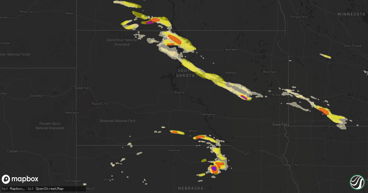
Hail Map in South Dakota on July 19, 2017
Get this storm
July 19 map
$229
one time, instant access
Download today. No call, no setup
Keep the $229
Bought the map and want the full workflow? Apply the entire $229 to a subscription within 7 days. None of it is wasted.
Every map, not just this one
This buys you this map. Subscription and you get every map we run, in the markets you choose from a few cities to whole states to nationwide. Plus real-time alerts the moment a storm fires.
Contact data
Name, contact info, occupancy, even credit band for addresses in the footprint. You go from where it hit to who to call.
Become the source they trust
Unlimited branding weather history reports on demand. You already have the documented answer ready for the property owner, and you are the one who showed up with it.
Property data and RoofTrace estimates
Pull up any address you have got, its value and the exact code rules for that jurisdiction, straight from One Click Code. Then RoofTrace estimates the squares, pitch, and roof value, priced the way you price.
Storm reports in South Dakota
South Dakota
| Date | Description |
|---|---|
| 07/19/20175:10 PM CDT | A local report indicates 1.00 inch wind near 8 E MISSION |
| 07/19/20174:15 PM CDT | A local report indicates 1.00 inch wind near 3 SW GREGORY |
| 07/19/20174:10 PM CDT | About a 1/2 of rain in 30 minutes. |
| 07/19/20173:35 PM CDT | A local report indicates 65 MPH wind near 5 S COLOME |
| 07/19/20171:30 PM CDT | Large barn and grain bin destroyed. Power poles and several trees blown over. Report via social media. |
| 07/19/20171:05 PM CDT | A local report indicates 74 MPH wind near 2 NNE BROOKINGS |
| 07/19/201712:30 PM CDT | A local report indicates 83 MPH wind near 2 N HURON |
| 07/19/201712:03 PM CDT | Golf ball to tennis ball size. |
| 07/19/201711:52 AM CDT | A local report indicates 72 MPH wind near 3 E CAVOUR |
| 07/19/201711:47 AM CDT | Irrigation pivots damaged. |
| 07/19/201711:36 AM CDT | Also nickel size hail. |
| 07/19/201711:36 AM CDT | A local report indicates 83 MPH wind near 2 N HURON |
| 07/19/201710:51 AM CDT | One inch in diameter tree branches broken off. |
| 07/19/201710:34 AM CDT | Large metal storage shed had one wall and half of the roof removed. Time estimated via radar. |
| 07/19/201710:30 AM CDT | 50 to 60 mph winds. Heavy rain reducing visibility and making travel difficult. Some ponding of water in ditches. |
| 07/19/201710:24 AM CDT | Winds knocked down an 18 inch in diameter tree. |
| 07/19/201710:22 AM CDT | Measured at rwis station at the intersection of sd47 and sd26. |
| 07/19/201710:21 AM CDT | A few small trees knocked over. |
| 07/19/201710:20 AM CDT | Significant tree damage... Damage to property... Will provide additional details at a later time. |
| 07/19/201710:20 AM CDT | 3 or 4 grain bins destroyed... A few miles north of this location... Trailer homes that were being moved were blown off of moving trailers. |
| 07/19/201710:01 AM CDT | A local report indicates 76 MPH wind near 5 SW LEBANON |
| 07/19/20179:53 AM CDT | A local report indicates 60 MPH wind near AKASKA |
| 07/19/20179:48 AM CDT | A local report indicates 65 MPH wind near GETTYSBURG |
| 07/19/20179:40 AM CDT | A local report indicates 70 MPH wind near 6 W BOWDLE |
| 07/19/20179:21 AM CDT | Ground covered with hail including numerous quarter size hailstones. Wind gusts of 60-70 mph. |
| 07/19/20179:15 AM CDT | Sheriff reported wind gusts of 60-70 mph. |
| 07/19/20179:08 AM CDT | 50 to 60 mph wind gusts... Crop damage from hail and/or wind... And some trees down. |
| 07/19/20179:04 AM CDT | A local report indicates 60 MPH wind near 5 WNW TRAIL CITY |
| 07/19/20178:30 AM CDT | A local report indicates 59 MPH wind near 2 SSE MAHTO |
All States Impacted by Hail Map on July 19, 2017
Cities Impacted by Hail Map on July 19, 2017
- Round Lake, IL
- Ingleside, IL
- Grayslake, IL
- Fairfax, SD
- Rocklake, ND
- Freeport, IL
- Pearl City, IL
- Hettinger, ND
- Selfridge, ND
- Fort Yates, ND
- Beloit, WI
- Clinton, WI
- Spanish Fork, UT
- Barnwell, SC
- Rolla, ND
- Saint John, ND
- Hansboro, ND
- Morocco, IN
- Fair Oaks, IN
- Demotte, IN
- Lake Village, IN
- Belcourt, ND
- Carson, ND
- Cavour, SD
- Huron, SD
- Iroquois, SD
- Raleigh, ND
- Ridgeway, SC
- Stuart, NE
- Atkinson, NE
- Walnut Grove, MN
- Tracy, MN
- Ellsworth, NE
- Dallas, SD
- Colome, SD
- Selby, SD
- Hay Springs, NE
- Ellabell, GA
- Parmelee, SD
- Rowesville, SC
- Orangeburg, SC
- Hanahan, SC
- North Charleston, SC
- Goose Creek, SC
- Charleston, SC
- Charleston Afb, SC
- Tyler, MN
- Lake Benton, MN
- Eastover, SC
- Gadsden, SC
- Summerville, SC
- Dalton, NE
- Ceylon, MN
- Dolliver, IA
- New Leipzig, ND
- Mott, ND
- Pennock, MN
- New London, MN
- Elgin, ND
- Guttenberg, IA
- Shickshinny, PA
- Miller, SD
- Wessington, SD
- Saint Lawrence, SD
- Wolsey, SD
- Artesian, SD
- Pinewood, SC
- Batesland, SD
- Lefor, ND
- Regent, ND
- Dickinson, ND
- Lumber City, GA
- Uvalda, GA
- Mount Vernon, GA
- Glenham, SD
- Java, SD
- Wakpala, SD
- Bloomfield, MT
- Glendive, MT
- Terry, MT
- Lindsay, MT
- Bassett, NE
- Fairmont, MN
- Mitchell, NE
- Cotopaxi, CO
- Rincon, GA
- Springfield, GA
- Hitchcock, SD
- Currie, MN
- Lemmon, SD
- Watauga, SD
- Keldron, SD
- Morristown, SD
- Saint Matthews, SC
- Sunburg, MN
- Murdock, MN
- Spicer, MN
- Chicago, IL
- Shields, ND
- Gurley, NE
- Oneill, NE
- Pearce, AZ
- Onida, SD
- Lebanon, SD
- Highmore, SD
- Gettysburg, SD
- Bloomingdale, GA
- Fort Stewart, GA
- Guyton, GA
- Sherburn, MN
- Welcome, MN
- Heron Lake, MN
- Broadwater, NE
- Salem, UT
- Trail City, SD
- McLaughlin, SD
- Little Eagle, SD
- Naper, NE
- Solen, ND
- Winner, SD
- Woodstock, IL
- Crystal Lake, IL
- Amelia, NE
- Mesquite, NM
- Anthony, NM
- La Mesa, NM
- Chamberino, NM
- Mobridge, SD
- Mound City, SD
- Elgin, IA
- Mission, SD
- Okreek, SD
- Blackshear, GA
- Scales Mound, IL
- Savanna, IL
- Stockton, IL
- Elizabeth, IL
- Apple River, IL
- Armstrong, IA
- Whitman, NE
- Fredonia, AZ
- Elkton, SD
- Slayton, MN
- Russell, MN
- Balaton, MN
- Ruthton, MN
- White, SD
- Arco, MN
- Garvin, MN
- Hendricks, MN
- Winnebago, IL
- Byron, IL
- Pecatonica, IL
- Ridott, IL
- Rockford, IL
- Maple Park, IL
- Elburn, IL
- Aurora, IL
- Sugar Grove, IL
- Elloree, SC
- Franklin Grove, IL
- Ashton, IL
- Dixon, IL
- Flagstaff, AZ
- Nunn, CO
- Torrington, WY
- Mills, NE
- Lugoff, SC
- Savage, MT
- Chanhassen, MN
- Excelsior, MN
- Shakopee, MN
- Herrick, SD
- Gregory, SD
- Burke, SD
- Saint Charles, SD
- Jackson, MN
- Ivanhoe, MN
- Shannon, IL
- Lanark, IL
- Polo, IL
- Forreston, IL
- Oldham, SD
- Arlington, SD
- Fennimore, WI
- Lancaster, WI
- Stitzer, WI
- Huger, SC
- Jesup, GA
- Brooker, FL
- Hampton, FL
- Minneapolis, MN
- Savage, MN
- Bowdle, SD
- Hoven, SD
- Colesburg, IA
- Glencross, SD
- Timber Lake, SD
- Eagle Butte, SD
- Rockton, IL
- Saint Stephen, SC
- Odum, GA
- Newport, NE
- Bonesteel, SD
- Butte, NE
- Chambers, NE
- Emmet, NE
- Janesville, WI
- Scottsbluff, NE
- Peridot, AZ
- Fairfield, ND
- Rochelle, IL
- Chana, IL
- Kirkland, IL
- Monroe Center, IL
- Davis Junction, IL
- Yale, SD
- Storden, MN
- Trimont, MN
- Alpha, MN
- Windom, MN
- Westbrook, MN
- Dunnell, MN
- Mountain Lake, MN
- Bingham Lake, MN
- Rembert, SC
- El Paso, TX
- Alliance, NE
- Woodford, WI
- Browntown, WI
- Monroe, WI
- South Wayne, WI
- Argyle, WI
- Blanchardville, WI
- Eden Prairie, MN
- Manning, SC
- Summerton, SC
- Church Point, LA
- Stillman Valley, IL
- Taylor, ND
- Gladstone, ND
- Jeffers, MN
- Dexter, MN
- Belmont, WI
- Darlington, WI
- Gratiot, WI
- Mineral Point, WI
- Merriman, NE
- Oswego, IL
- Potter, NE
- Blackville, SC
- Esmond, IL
- Rock City, IL
- Davis, IL
- Leaf River, IL
- German Valley, IL
- Dakota, IL
- Lindenwood, IL
- Georgetown, DE
- Antioch, IL
- Bristol, WI
- Kenosha, WI
- Plainfield, IL
- Rushville, NE
- Sanborn, MN
- Morgan City, LA
- Lena, IL
- Luana, IA
- Monona, IA
- Waukon, IA
- Postville, IA
- Faulkton, SD
- Malta, IL
- Sedalia, CO
- Holcomb, IL
- Brodhead, WI
- Norris, SD
- Granada, MN
- Tularosa, NM
- Orient, SD
- Moncks Corner, SC
- Genoa City, WI
- Richmond, IL
- Hyannis, NE
- Leupp, AZ
- Dunseith, ND
- Dekalb, IL
- Sycamore, IL
- Clare, IL
- Brookings, SD
- Sumter, SC
- Inman, NE
- Munich, ND
- Lakeland, FL
- Saint Paul, MN
- Burnsville, MN
- Lake Geneva, WI
- Williams Bay, WI
- New England, ND
- Richardton, ND
- Roscoe, IL
- Caledonia, IL
- Dovray, MN
- Avoca, MN
- Decorah, IA
- Saint Augustine, FL
- Bloomington, WI
- Greeleyville, SC
- Volga, IA
- Strawberry Point, IA
- Wadena, IA
- Arlington, IA
- Elkader, IA
- Evansville, WI
- Hardeeville, SC
- Footville, WI
- Wheatfield, IN
- Porcupine, SD
- Long Pine, NE
- Tulare, SD
- Manly, IA
- Flasher, ND
- Warren, IL
- Shullsburg, WI
- Kent, IL
- Lake Wilson, MN
- Pipestone, MN
- Holland, MN
- Edgerton, MN
- Iona, MN
- Woodstock, MN
- Flandreau, SD
- Chandler, MN
- Dubuque, IA
- Potosi, WI
- Sherrill, IA
- Cuba City, WI
- Austin, MN
- Loves Park, IL
- Yoder, WY
- Wheatland, WY
- McConnell, IL
- Winslow, IL
- Mount Carroll, IL
- Bellingham, MN
- Odessa, MN
- Ridgeland, SC
- Livingston, WI
- Linden, WI
- Rewey, WI
- Montfort, WI
- Blue Earth, MN
- Almont, ND
- Cortland, IL
- Alamogordo, NM
- White River, SD
- Hawk Springs, WY
- Lee, IL
- Orangeville, IL
- Kingston, IL
- Hampshire, IL
- Steward, IL
- Durand, IL
- McIntosh, SD
- Cassatt, SC
- Glenwood, GA
- Martin, SD
- Preston, MN
- Mundelein, IL
- Port Wentworth, GA
- Fulda, MN
- Seneca, SD
- Hastings, MN
- Lamberton, MN
- Monticello, WI
- Beaufort, SC
- Okatie, SC
- Chaska, MN
- Ville Platte, LA
- Eunice, LA
- Cross, SC
- Wadsworth, IL
- Gurnee, IL
- Lake Villa, IL
- Bristol, IL
- Montgomery, IL
- Yorkville, IL
- Bolingbrook, IL
- Napoleonville, LA
- Poplar Grove, IL
- Capron, IL
- Harvard, IL
- Juda, WI
- Swea City, IA
- Ledyard, IA
- Lake City, FL
- Aurora, SD
- Truman, MN
- Estherville, IA
- Odin, MN
- Avalon, WI
- Sharon, WI
- Darien, WI
- Revere, MN
- Galena, IL
- East Dubuque, IL
- Ludowici, GA
- Johns Island, SC
- Ailey, GA
- Platteville, WI
- Onaka, SD
- Waterville, IA
- Georgetown, SC
- La Luz, NM
- Wallsburg, UT
- Dalzell, SC
- Milledgeville, IL
- West Brooklyn, IL
- Compton, IL
- Oregon, IL
- Calvin, ND
- Winnsboro, SC
- Waconia, MN
- Saint Bonifacius, MN
- Victoria, MN
- Watertown, MN
- Mound, MN
- Maple Plain, MN
- Spring Valley, MN
- Grand Meadow, MN
- Taylor, NE
- Springview, NE
- Belvidere, IL
- Carthage, SD
- Alpena, SD
- Pollock, SD
- Lake Preston, SD
- De Smet, SD
- Rockham, SD
- Elizabeth, CO
- Fountain, MN
- Wykoff, MN
- Harpers Ferry, IA
- Bagley, WI
- Patch Grove, WI
- Paw Paw, IL
- Payson, UT
- Polk City, FL
- Screven, GA
- Abbeville, LA
- Elmore, MN
- Frost, MN
- Saint Olaf, IA
- Union, IL
- Huntley, IL
- Lake In The Hills, IL
- Belfield, ND
- Kissimmee, FL
- Rock Hill, SC
- Holly Hill, SC
- Circle, MT
- Brockway, MT
- Glen Ullin, ND
- Herreid, SD
- Holabird, SD
- Sedona, AZ
- Dakota, MN
- Winona, MN
- La Crosse, WI
- Trempealeau, WI
- Onalaska, WI
- Fountain City, WI
- Rollingstone, MN
- La Crescent, MN
- Minnesota City, MN
- Holmen, WI


