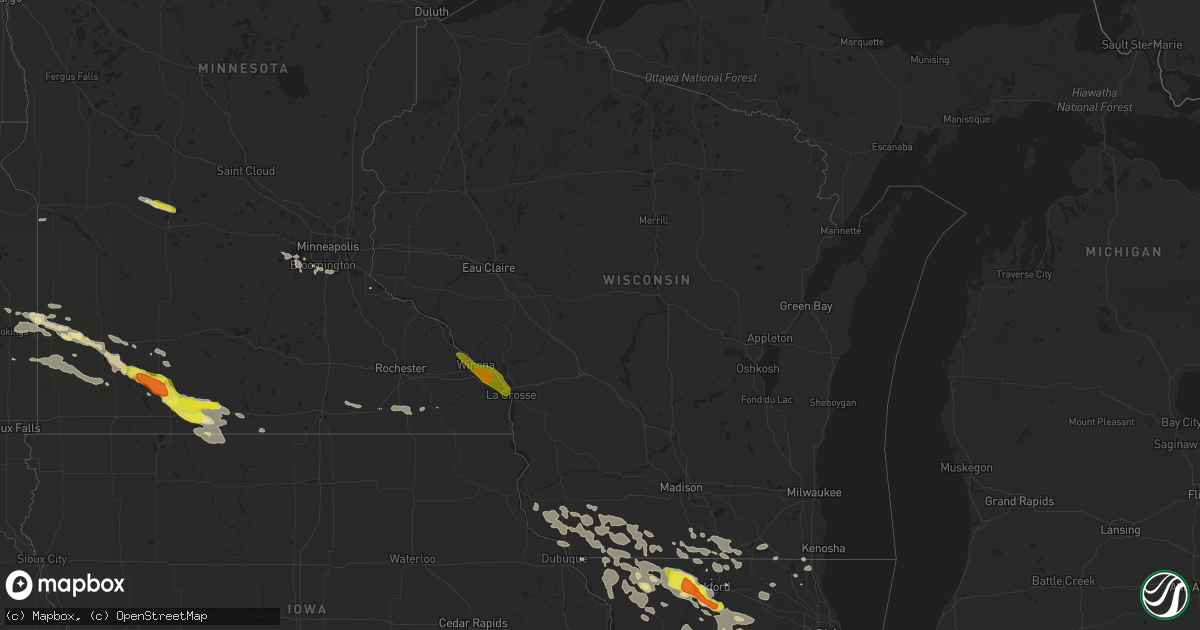
Hail Map in Wisconsin on July 19, 2017
Get this storm
July 19 map
$229
one time, instant access
Download today. No call, no setup
Keep the $229
Bought the map and want the full workflow? Apply the entire $229 to a subscription within 7 days. None of it is wasted.
Every map, not just this one
This buys you this map. Subscription and you get every map we run, in the markets you choose from a few cities to whole states to nationwide. Plus real-time alerts the moment a storm fires.
Contact data
Name, contact info, occupancy, even credit band for addresses in the footprint. You go from where it hit to who to call.
Become the source they trust
Unlimited branding weather history reports on demand. You already have the documented answer ready for the property owner, and you are the one who showed up with it.
Property data and RoofTrace estimates
Pull up any address you have got, its value and the exact code rules for that jurisdiction, straight from One Click Code. Then RoofTrace estimates the squares, pitch, and roof value, priced the way you price.
Storm reports in Wisconsin
Wisconsin
| Date | Description |
|---|---|
| 07/19/20176:55 PM CDT | Tree damage... Including an oak falling on power lines. Time estimated from radar. |
| 07/19/20176:51 PM CDT | Trees and power lines down. |
| 07/19/20176:51 PM CDT | Branches down. |
| 07/19/20176:50 PM CDT | Estimated 65 mph wind. |
| 07/19/20176:50 PM CDT | A local report indicates 61 MPH wind near 5 ENE ELLENBORO |
| 07/19/20176:50 PM CDT | A local report indicates 70 MPH wind near PLATTEVILLE |
| 07/19/20176:49 PM CDT | Trees/powerlines down. Significant damage. Power outages. |
| 07/19/20176:47 PM CDT | Trees damaged. |
| 07/19/20176:45 PM CDT | Tree limbs down. Size was up to 6 inches in diameter. Numerous limbs down. |
| 07/19/20176:41 PM CDT | Large branches down along south ave. |
| 07/19/20176:34 PM CDT | Large branches down in village. Time estimated. |
| 07/19/20176:28 PM CDT | Several pine tree limbs damaged. Top 6 feet of a 25 ft tall pine tree broken or twisted off and flung several feet. |
| 07/19/20176:27 PM CDT | Shed damaged. 4-wheeler blown over from extreme winds. |
| 07/19/20176:25 PM CDT | A local report indicates 70 MPH wind near PATCH GROVE |
| 07/19/20176:25 PM CDT | A local report indicates 60 MPH wind near 1 SSE DE SOTO |
| 07/19/20176:20 PM CDT | Hanger damaged at airport. Time estimated. |
| 07/19/20176:20 PM CDT | Trees down and corn damage just east of prairie du chien. |
| 07/19/20175:40 PM CDT | Trees down on south side of town. Reported via facebook. Time estimated from wind gust of 46 mph at eau claire chippewa valley regional airport |
| 07/19/20175:40 PM CDT | Two large trees down blocking road. Reported at 3443 crescent ave... Eau claire... Wi. |
| 07/19/20177:40 AM CDT | A lot of downed trees reported from the township road department |
| 07/18/201711:35 PM CDT | Power line down. Time estimated from radar. |
| 07/18/20179:17 PM CDT | Tree down downtown. 911 center on backup generator |
| 07/18/20179:15 PM CDT | Delayed report. Tree downed. Unknown size |
| 07/18/20178:50 PM CDT | Tree across road |
| 07/18/20178:50 PM CDT | Tree down across the road |
| 07/18/20178:50 PM CDT | Trees down |
| 07/18/20178:40 PM CDT | Couple docks and a boatlift damaged along lake poygan. Estimated wind gusts to 50 mph |
| 07/18/20178:06 PM CDT | Several trees and branches down throughout rock county. Time of event estimated from weather radar. |
| 07/18/20178:00 PM CDT | 8 inch maple knocked down with gust behind the storms |
| 07/18/20177:59 PM CDT | Large branches falling in town. |
| 07/18/20177:47 PM CDT | Trees down in monroe. |
| 07/18/20177:45 PM CDT | Large tree limbs down. Estimated 65 mph wind. |
| 07/18/20177:45 PM CDT | Greater than 2 inch diameter tree branches down. Heavy downpour with high winds. Rain was horizontal at times. Rainfall of 0.50-0.74 inches in 15 minutes. |
| 07/18/20177:42 PM CDT | Trees and power lines down in multiple areas of green county. |
| 07/18/20177:35 PM CDT | Trees and power lines down in far western portions of sauk county with line of storms. Time estimated from radar. |
| 07/18/20177:34 PM CDT | Delayed report. Trees and power lines down. Time estimated from radar. |
| 07/18/20177:25 PM CDT | Trees and power lines down. |
| 07/18/20177:22 PM CDT | Trees down and damage to metal shed...no power. |
| 07/18/20177:19 PM CDT | Trees and power lines down in the western part of iowa county. No other details available. |
| 07/18/20177:18 PM CDT | Trees and power lines down in the western part of lafayette county. No other details available. |
| 07/18/20177:16 PM CDT | Power lines down and large tree branches down in cobb and mineral point. |
| 07/18/20177:13 PM CDT | Trees and power lines down. |
| 07/18/20177:00 PM CDT | Trees and power lines down. |
All States Impacted by Hail Map on July 19, 2017
Cities Impacted by Hail Map on July 19, 2017
- Round Lake, IL
- Ingleside, IL
- Grayslake, IL
- Fairfax, SD
- Rocklake, ND
- Freeport, IL
- Pearl City, IL
- Hettinger, ND
- Selfridge, ND
- Fort Yates, ND
- Beloit, WI
- Clinton, WI
- Spanish Fork, UT
- Barnwell, SC
- Rolla, ND
- Saint John, ND
- Hansboro, ND
- Morocco, IN
- Fair Oaks, IN
- Demotte, IN
- Lake Village, IN
- Belcourt, ND
- Carson, ND
- Cavour, SD
- Huron, SD
- Iroquois, SD
- Raleigh, ND
- Ridgeway, SC
- Stuart, NE
- Atkinson, NE
- Walnut Grove, MN
- Tracy, MN
- Ellsworth, NE
- Dallas, SD
- Colome, SD
- Selby, SD
- Hay Springs, NE
- Ellabell, GA
- Parmelee, SD
- Rowesville, SC
- Orangeburg, SC
- Hanahan, SC
- North Charleston, SC
- Goose Creek, SC
- Charleston, SC
- Charleston Afb, SC
- Tyler, MN
- Lake Benton, MN
- Eastover, SC
- Gadsden, SC
- Summerville, SC
- Dalton, NE
- Ceylon, MN
- Dolliver, IA
- New Leipzig, ND
- Mott, ND
- Pennock, MN
- New London, MN
- Elgin, ND
- Guttenberg, IA
- Shickshinny, PA
- Miller, SD
- Wessington, SD
- Saint Lawrence, SD
- Wolsey, SD
- Artesian, SD
- Pinewood, SC
- Batesland, SD
- Lefor, ND
- Regent, ND
- Dickinson, ND
- Lumber City, GA
- Uvalda, GA
- Mount Vernon, GA
- Glenham, SD
- Java, SD
- Wakpala, SD
- Bloomfield, MT
- Glendive, MT
- Terry, MT
- Lindsay, MT
- Bassett, NE
- Fairmont, MN
- Mitchell, NE
- Cotopaxi, CO
- Rincon, GA
- Springfield, GA
- Hitchcock, SD
- Currie, MN
- Lemmon, SD
- Watauga, SD
- Keldron, SD
- Morristown, SD
- Saint Matthews, SC
- Sunburg, MN
- Murdock, MN
- Spicer, MN
- Chicago, IL
- Shields, ND
- Gurley, NE
- Oneill, NE
- Pearce, AZ
- Onida, SD
- Lebanon, SD
- Highmore, SD
- Gettysburg, SD
- Bloomingdale, GA
- Fort Stewart, GA
- Guyton, GA
- Sherburn, MN
- Welcome, MN
- Heron Lake, MN
- Broadwater, NE
- Salem, UT
- Trail City, SD
- McLaughlin, SD
- Little Eagle, SD
- Naper, NE
- Solen, ND
- Winner, SD
- Woodstock, IL
- Crystal Lake, IL
- Amelia, NE
- Mesquite, NM
- Anthony, NM
- La Mesa, NM
- Chamberino, NM
- Mobridge, SD
- Mound City, SD
- Elgin, IA
- Mission, SD
- Okreek, SD
- Blackshear, GA
- Scales Mound, IL
- Savanna, IL
- Stockton, IL
- Elizabeth, IL
- Apple River, IL
- Armstrong, IA
- Whitman, NE
- Fredonia, AZ
- Elkton, SD
- Slayton, MN
- Russell, MN
- Balaton, MN
- Ruthton, MN
- White, SD
- Arco, MN
- Garvin, MN
- Hendricks, MN
- Winnebago, IL
- Byron, IL
- Pecatonica, IL
- Ridott, IL
- Rockford, IL
- Maple Park, IL
- Elburn, IL
- Aurora, IL
- Sugar Grove, IL
- Elloree, SC
- Franklin Grove, IL
- Ashton, IL
- Dixon, IL
- Flagstaff, AZ
- Nunn, CO
- Torrington, WY
- Mills, NE
- Lugoff, SC
- Savage, MT
- Chanhassen, MN
- Excelsior, MN
- Shakopee, MN
- Herrick, SD
- Gregory, SD
- Burke, SD
- Saint Charles, SD
- Jackson, MN
- Ivanhoe, MN
- Shannon, IL
- Lanark, IL
- Polo, IL
- Forreston, IL
- Oldham, SD
- Arlington, SD
- Fennimore, WI
- Lancaster, WI
- Stitzer, WI
- Huger, SC
- Jesup, GA
- Brooker, FL
- Hampton, FL
- Minneapolis, MN
- Savage, MN
- Bowdle, SD
- Hoven, SD
- Colesburg, IA
- Glencross, SD
- Timber Lake, SD
- Eagle Butte, SD
- Rockton, IL
- Saint Stephen, SC
- Odum, GA
- Newport, NE
- Bonesteel, SD
- Butte, NE
- Chambers, NE
- Emmet, NE
- Janesville, WI
- Scottsbluff, NE
- Peridot, AZ
- Fairfield, ND
- Rochelle, IL
- Chana, IL
- Kirkland, IL
- Monroe Center, IL
- Davis Junction, IL
- Yale, SD
- Storden, MN
- Trimont, MN
- Alpha, MN
- Windom, MN
- Westbrook, MN
- Dunnell, MN
- Mountain Lake, MN
- Bingham Lake, MN
- Rembert, SC
- El Paso, TX
- Alliance, NE
- Woodford, WI
- Browntown, WI
- Monroe, WI
- South Wayne, WI
- Argyle, WI
- Blanchardville, WI
- Eden Prairie, MN
- Manning, SC
- Summerton, SC
- Church Point, LA
- Stillman Valley, IL
- Taylor, ND
- Gladstone, ND
- Jeffers, MN
- Dexter, MN
- Belmont, WI
- Darlington, WI
- Gratiot, WI
- Mineral Point, WI
- Merriman, NE
- Oswego, IL
- Potter, NE
- Blackville, SC
- Esmond, IL
- Rock City, IL
- Davis, IL
- Leaf River, IL
- German Valley, IL
- Dakota, IL
- Lindenwood, IL
- Georgetown, DE
- Antioch, IL
- Bristol, WI
- Kenosha, WI
- Plainfield, IL
- Rushville, NE
- Sanborn, MN
- Morgan City, LA
- Lena, IL
- Luana, IA
- Monona, IA
- Waukon, IA
- Postville, IA
- Faulkton, SD
- Malta, IL
- Sedalia, CO
- Holcomb, IL
- Brodhead, WI
- Norris, SD
- Granada, MN
- Tularosa, NM
- Orient, SD
- Moncks Corner, SC
- Genoa City, WI
- Richmond, IL
- Hyannis, NE
- Leupp, AZ
- Dunseith, ND
- Dekalb, IL
- Sycamore, IL
- Clare, IL
- Brookings, SD
- Sumter, SC
- Inman, NE
- Munich, ND
- Lakeland, FL
- Saint Paul, MN
- Burnsville, MN
- Lake Geneva, WI
- Williams Bay, WI
- New England, ND
- Richardton, ND
- Roscoe, IL
- Caledonia, IL
- Dovray, MN
- Avoca, MN
- Decorah, IA
- Saint Augustine, FL
- Bloomington, WI
- Greeleyville, SC
- Volga, IA
- Strawberry Point, IA
- Wadena, IA
- Arlington, IA
- Elkader, IA
- Evansville, WI
- Hardeeville, SC
- Footville, WI
- Wheatfield, IN
- Porcupine, SD
- Long Pine, NE
- Tulare, SD
- Manly, IA
- Flasher, ND
- Warren, IL
- Shullsburg, WI
- Kent, IL
- Lake Wilson, MN
- Pipestone, MN
- Holland, MN
- Edgerton, MN
- Iona, MN
- Woodstock, MN
- Flandreau, SD
- Chandler, MN
- Dubuque, IA
- Potosi, WI
- Sherrill, IA
- Cuba City, WI
- Austin, MN
- Loves Park, IL
- Yoder, WY
- Wheatland, WY
- McConnell, IL
- Winslow, IL
- Mount Carroll, IL
- Bellingham, MN
- Odessa, MN
- Ridgeland, SC
- Livingston, WI
- Linden, WI
- Rewey, WI
- Montfort, WI
- Blue Earth, MN
- Almont, ND
- Cortland, IL
- Alamogordo, NM
- White River, SD
- Hawk Springs, WY
- Lee, IL
- Orangeville, IL
- Kingston, IL
- Hampshire, IL
- Steward, IL
- Durand, IL
- McIntosh, SD
- Cassatt, SC
- Glenwood, GA
- Martin, SD
- Preston, MN
- Mundelein, IL
- Port Wentworth, GA
- Fulda, MN
- Seneca, SD
- Hastings, MN
- Lamberton, MN
- Monticello, WI
- Beaufort, SC
- Okatie, SC
- Chaska, MN
- Ville Platte, LA
- Eunice, LA
- Cross, SC
- Wadsworth, IL
- Gurnee, IL
- Lake Villa, IL
- Bristol, IL
- Montgomery, IL
- Yorkville, IL
- Bolingbrook, IL
- Napoleonville, LA
- Poplar Grove, IL
- Capron, IL
- Harvard, IL
- Juda, WI
- Swea City, IA
- Ledyard, IA
- Lake City, FL
- Aurora, SD
- Truman, MN
- Estherville, IA
- Odin, MN
- Avalon, WI
- Sharon, WI
- Darien, WI
- Revere, MN
- Galena, IL
- East Dubuque, IL
- Ludowici, GA
- Johns Island, SC
- Ailey, GA
- Platteville, WI
- Onaka, SD
- Waterville, IA
- Georgetown, SC
- La Luz, NM
- Wallsburg, UT
- Dalzell, SC
- Milledgeville, IL
- West Brooklyn, IL
- Compton, IL
- Oregon, IL
- Calvin, ND
- Winnsboro, SC
- Waconia, MN
- Saint Bonifacius, MN
- Victoria, MN
- Watertown, MN
- Mound, MN
- Maple Plain, MN
- Spring Valley, MN
- Grand Meadow, MN
- Taylor, NE
- Springview, NE
- Belvidere, IL
- Carthage, SD
- Alpena, SD
- Pollock, SD
- Lake Preston, SD
- De Smet, SD
- Rockham, SD
- Elizabeth, CO
- Fountain, MN
- Wykoff, MN
- Harpers Ferry, IA
- Bagley, WI
- Patch Grove, WI
- Paw Paw, IL
- Payson, UT
- Polk City, FL
- Screven, GA
- Abbeville, LA
- Elmore, MN
- Frost, MN
- Saint Olaf, IA
- Union, IL
- Huntley, IL
- Lake In The Hills, IL
- Belfield, ND
- Kissimmee, FL
- Rock Hill, SC
- Holly Hill, SC
- Circle, MT
- Brockway, MT
- Glen Ullin, ND
- Herreid, SD
- Holabird, SD
- Sedona, AZ
- Dakota, MN
- Winona, MN
- La Crosse, WI
- Trempealeau, WI
- Onalaska, WI
- Fountain City, WI
- Rollingstone, MN
- La Crescent, MN
- Minnesota City, MN
- Holmen, WI


