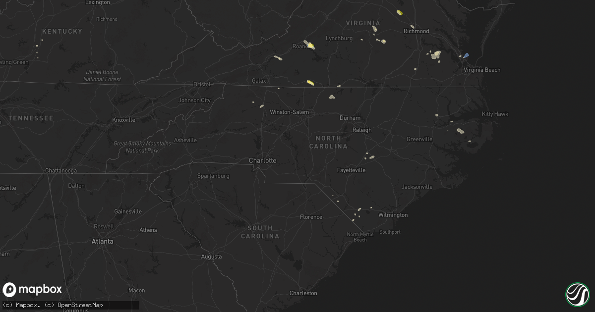
Hail Map in North Carolina on July 18, 2025
Get this storm
July 18 map
$229
one time, instant access
Download today. No call, no setup
Keep the $229
Bought the map and want the full workflow? Apply the entire $229 to a subscription within 7 days. None of it is wasted.
Every map, not just this one
This buys you this map. Subscription and you get every map we run, in the markets you choose from a few cities to whole states to nationwide. Plus real-time alerts the moment a storm fires.
Contact data
Name, contact info, occupancy, even credit band for addresses in the footprint. You go from where it hit to who to call.
Become the source they trust
Unlimited branding weather history reports on demand. You already have the documented answer ready for the property owner, and you are the one who showed up with it.
Property data and RoofTrace estimates
Pull up any address you have got, its value and the exact code rules for that jurisdiction, straight from One Click Code. Then RoofTrace estimates the squares, pitch, and roof value, priced the way you price.
Storm reports in North Carolina
North Carolina
| Date | Description |
|---|---|
| 07/18/20256:58 PM CDT | Power line down along rosewood road near autumn winds drive. |
| 07/18/20256:55 PM CDT | Tree down near west memorial highway. |
| 07/18/20256:55 PM CDT | Tree down near west memorial highway and souther road. |
| 07/18/20256:34 PM CDT | Power outage caused by fallen trees damaging equipment along nc-96 and keen road near four oaks. |
| 07/18/20256:21 PM CDT | Wral on scene where eastbound lanes of i-40 were closed near mile marker 338 due to several trees down... One of which fell on a car. No injuries reported. |
| 07/18/20255:58 PM CDT | Power outage caused by fallen trees near godwin. |
| 07/18/20255:51 PM CDT | Tree down at godwin-falcon rd and allie cooper rd. |
| 07/18/20255:47 PM CDT | Tree down on bunnlevel erwin rd. |
| 07/18/20254:55 PM CDT | Tree and powerline down along wheelers church road near the intersection with burlington road. |
| 07/18/20252:00 PM CDT | Tree down blocking both lanes of travel on belvue drive in mount airy... Nc. |
| 07/18/20251:15 PM CDT | Tree down near the intersection of epperson church road and banks valley lane in mount airy... Nc. |
| 07/18/20251:06 PM CDT | Tree down near the intersection of east pine street and slate mountain road in mount airy... Nc. |
| 07/17/20258:00 PM CDT | Tree downed by thunderstorm winds at the intersection of jessup road and asbury road. |
| 07/17/20257:48 PM CDT | Tree downed by thunderstorm winds at the intersection of beamer road and maple grove church road... And landed in the roadway. |
| 07/17/20257:46 PM CDT | Tree downed by thunderstorm winds... And blocking one lane... On stanford church road. |
| 07/17/20257:46 PM CDT | Tree downed by thunderstorm winds... And fell on a powerline. |
| 07/17/20257:33 PM CDT | Tree downed by thunderstorm winds near the intersection of jenkinstown road and crest rock trail. |
| 07/17/20257:25 PM CDT | Tree downed by thunderstorm winds on nc state road 268... And blocked one side of the road... And also partially caught a powerline. |
| 07/17/20257:01 PM CDT | Delayed report. Tideland electric membership corporation reported two broken power poles and downed wire resulting in power outages. Time estimated from radar. |
All States Impacted by Hail Map on July 18, 2025
Cities Impacted by Hail Map on July 18, 2025
- Axton, VA
- Ridgeway, VA
- Vinton, VA
- Goodview, VA
- Moneta, VA
- Mineral, VA
- Bumpass, VA
- Montpelier, VA
- Milan, KS
- Argonia, KS
- Conway Springs, KS
- Clearwater, KS
- Viola, KS
- Midwest, WY
- Casper, WY
- Thermopolis, WY
- Worland, WY
- Wichita, KS
- Haysville, KS
- Valley Center, KS
- Kechi, KS
- Wheatland, WY
- Guernsey, WY
- Fort Laramie, WY
- Sedgwick, KS
- Newton, KS
- Whitewater, KS
- Yoder, WY
- Manville, WY
- Shawnee, WY
- Glendo, WY
- Torrington, WY
- Lingle, WY
- Kim, CO
- Pritchett, CO
- Granite Falls, MN
- Sacred Heart, MN
- Maynard, MN
- Clarkfield, MN
- Montevideo, MN
- Wood Lake, MN
- Echo, MN
- Clara City, MN
- Belview, MN
- Renville, MN
- Lusk, WY
- Lance Creek, WY
- Ainsworth, NE
- Johnstown, NE
- Morrill, NE
- Lyman, NE
- Hampton, VA
- Poquoson, VA
- Mitchell, NE
- Gering, NE
- Scottsbluff, NE
- Richmond, MN
- Grove City, MN
- New London, MN
- Paynesville, MN
- Atwater, MN
- Spicer, MN
- Eden Valley, MN
- Watkins, MN
- Cold Spring, MN
- Kimball, MN
- Minatare, NE
- Melbeta, NE
- South Haven, MN
- Saint Cloud, MN
- Clearwater, MN
- Bayard, NE
- Burwell, NE
- Harrisburg, NE
- Sibley, IA
- Melvin, IA
- Ashton, IA
- Sheldon, IA
- Sanborn, IA
- Ocheyedan, IA
- Hartley, IA
- George, IA
- Everly, IA
- Spencer, IA
- Harris, IA
- Milford, IA
- Lake Park, IA
- Primghar, IA
- Rockville, MN
- Walton, KS
- Peabody, KS
- Elbing, KS
- Merrill, WI
- Athens, WI
- Rib Lake, WI
- Medford, WI
- Wausau, WI
- Boone, IA
- Stratford, IA
- Ames, IA
- Aniwa, WI
- Birnamwood, WI
- Antigo, WI
- Bowler, WI
- Clear Lake, MN
- Kennebec, SD
- Lower Brule, SD
- Byrdstown, TN
- Martinsville, VA
- Riner, VA
- Christiansburg, VA
- Ravenel, SC
- Conway, SC
- Radford, VA
- Trinidad, CO
- Monte Vista, CO
- Latta, SC
- Rowland, NC
- Meeteetse, WY
- Magnolia, KY
- Jetersville, VA
- Amelia Court House, VA
- Moncks Corner, SC
- Capitan, NM
- Paducah, KY
- Monroe, LA
- Alton, VA
- Whiteville, NC
- Princeton, KY
- Fairfield, NC
- Trementina, NM
- Appomattox, VA
- Pamplin, VA
- Monroe, TN
- Las Vegas, NV
- Chadbourn, NC
- Clarendon, NC
- Dublin, VA
- Hurricane, UT
- Okatie, SC
- Kaycee, WY
- Waverly, VA
- Spring Grove, VA
- Hanley Falls, MN
- West Monroe, LA
- Stony Creek, VA
- Disputanta, VA
- Fairmont, NC
- Del Norte, CO
- Pilot, VA
- Metropolis, IL
- Brookport, IL
- Bolton, NC
- Roanoke, VA
- Cloverdale, VA
- Rice, VA
- Watertown, SD
- Tamms, IL
- Mounds, IL
- Amorita, OK
- Burlington, OK
- Canby, MN
- Porter, MN
- Taunton, MN
- Gary, SD
- Clear Lake, SD
- Loris, SC
- Farmville, VA
- Grenville, NM
- Folkston, GA
- Hermitage, AR
- Cumberland, VA
- Dillwyn, VA
- Georgetown, SC
- Cherokee, OK
- Shawneetown, IL
- Munfordville, KY
- Callahan, FL
- Bluff City, KS
- Richmond, VA
- Henrico, VA
- Raton, NM
- Strandburg, SD
- Caldwell, KS
- Freeport, KS
- Maxwell, NM
- Morrilton, AR
- Benson, NC
- Dunn, NC
- Powell, WY
- White City, KS
- Herington, KS
- Burlington, NC
- Yanceyville, NC
- Mebane, NC
- Hardy, VA
- Goodwin, SD
- Douglas, WY
- Newton Grove, NC
- Revillo, SD
- Marietta, MN
- Tabor City, NC
- Wakefield, VA
- Glasgow, KY
- Milroy, MN
- Vesta, MN
- Goddard, KS
- Strong City, KS
- Emporia, KS
- Darlington, SC
- Ghent, MN
- Roper, NC
- Winona, MO
- North Wilkesboro, NC
- Roaring River, NC
- Junction City, KS
- Cottonwood, MN
- Marshall, MN
- Minneota, MN
- Bluffton, SC
- Hartville, WY
- Newport News, VA
- Yorktown, VA
- Cave City, KY
- Horse Cave, KY
- Dendron, VA
- Burns, KS
- Amelia, NE
- Jarratt, VA
- Lynd, MN
- Litchfield, MN
- Darwin, MN
- Florence, SD
- Mount Airy, NC
- Brewster, NE
- Tracy, MN
- Plymouth, NC
- Gurdon, AR
- Arkadelphia, AR
- Colwich, KS
- Fairfax, SD
- Walnut Grove, MN
- Windsor, NC
- Prescott, AR
- Golconda, IL
- Herod, IL
- Andale, KS
- Jonesville, NC
- Ronda, NC
- Creswell, NC
- West Plains, MO
- Revere, MN
- Rogers, MN
- Turtle Lake, WI
- Saint Croix Falls, WI
- Dresser, WI
- Ericson, NE
- Greeley, NE
- Scotia, NE
- Ord, NE
- Bartlett, NE
- Spalding, NE
- Taylor, NE
- Butterfield, MN
- Saint James, MN
- Bassett, NE
- Lamberton, MN
- Arvonia, VA
- Comfrey, MN
- Mountain Lake, MN
- Purdum, NE
- Lakefield, MN
- Round Lake, MN
- Bridgeport, NE
- Jeffers, MN
- Bingham Lake, MN
- Springfield, MN
- Sanborn, MN
- Spirit Lake, IA
- Jackson, MN
- Long Pine, NE
- Granada, MN
- Fairmont, MN
- Truman, MN
- Jetmore, KS
- Butte, NE
- Naper, NE
- Beresford, SD
- Corsica, SD
- Geddes, SD
- Okabena, MN
- Thompson, IA
- Buffalo Center, IA
- Elmore, MN
- Rake, IA
- Frost, MN
- Newport, NE
- Ormsby, MN
- Odin, MN
- Blue Earth, MN
- Winnebago, MN
- Swea City, IA
- Ledyard, IA
- Stuart, NE
- Atkinson, NE
- Angora, NE
- Mallard, IA
- Havelock, IA
- West Bend, IA
- Ottosen, IA
- Algona, IA
- Centerville, SD
- Lennox, SD
- Burke, SD
- Rock Rapids, IA
- Rolfe, IA
- Bode, IA
- Belmond, IA
- Kanawha, IA
- Clarion, IA
- Goldfield, IA
- Renwick, IA
- Leland, IA
- Lu Verne, IA
- Livermore, IA
- Chambers, NE
- Armour, SD
- Glen Allen, VA
- Alden, IA
- Eagle Grove, IA
- Badger, IA
- Clare, IA
- Fort Dodge, IA
- Humboldt, IA
- Dows, IA
- Alexander, IA
- Rowan, IA
- Latimer, IA
- Galt, IA
- Hardy, IA
- Blairsburg, IA
- Williams, IA
- Lake Andes, SD
- Emmetsburg, IA
- Bonesteel, SD
- Saint Charles, SD
- Thor, IA
- Woolstock, IA
- Vincent, IA
- Thornton, IA
- Swaledale, IA
- Ethan, SD
- Traer, IA
- Brusett, MT
- Cylinder, IA
- Whittemore, IA
- Canistota, SD
- Sheffield, IA
- New Sharon, IA
- Ogden, IA
- Paton, IA
- Iowa Falls, IA
- Popejoy, IA
- Salem, SD
- Jefferson, IA
- Churdan, IA
- Bradgate, IA
- Bouton, IA
- Doon, IA
- Polk City, IA
- Woodward, IA
- Madrid, IA
- Perry, IA
- Alexandria, SD
- Grand Junction, IA
- Dana, IA
- Dumont, IA
- Ottumwa, IA
- Dimock, SD
- Parkston, SD
- Hampton, IA
- Kamrar, IA
- Webster City, IA
- Ackley, IA
- Geneva, IA
- Meservey, IA
- Klemme, IA
- Goodell, IA
- Curlew, IA
- Dysart, IA
- Clear Lake, IA
- Gladbrook, IA
- Austinville, IA
- Parkersburg, IA
- New Hartford, IA
- Stout, IA
- Aplington, IA
- Garner, IA
- Scarville, IA
- Gilmore City, IA
- Boxholm, IA
- Rippey, IA
- Bridgewater, SD
- Jordan, MT
- Agency, IA
- Archer, IA
- Delmont, SD
- Garwin, IA
- Toledo, IA
- Luther, IA
- Jamaica, IA
- Dawson, IA
- Sheldahl, IA
- Slater, IA
- Dayton, IA
- Pilot Mound, IA
- Lehigh, IA
- Belle Plaine, IA
- Chelsea, IA
- Blairstown, IA
- Elberon, IA
- Van Horne, IA
- Luzerne, IA
- Keystone, IA
- Shell Rock, IA
- Woden, IA
- Titonka, IA
- Radcliffe, IA
- Cedar Falls, IA
- Dike, IA
- Milton, NC
- La Porte City, IA
- Flint Hill, VA
- Huntly, VA
- Cairo, IL
- Las Vegas, NM
- Pulaski, IL
- Platte, SD
- Garrison, IA
- Columbia, NC
- Jesup, GA
- Coulter, IA
- Malta, MT
- Summerfield, IL
- Trenton, IL
- Ringle, WI
- Kelley, IA
- Marathon, WI


