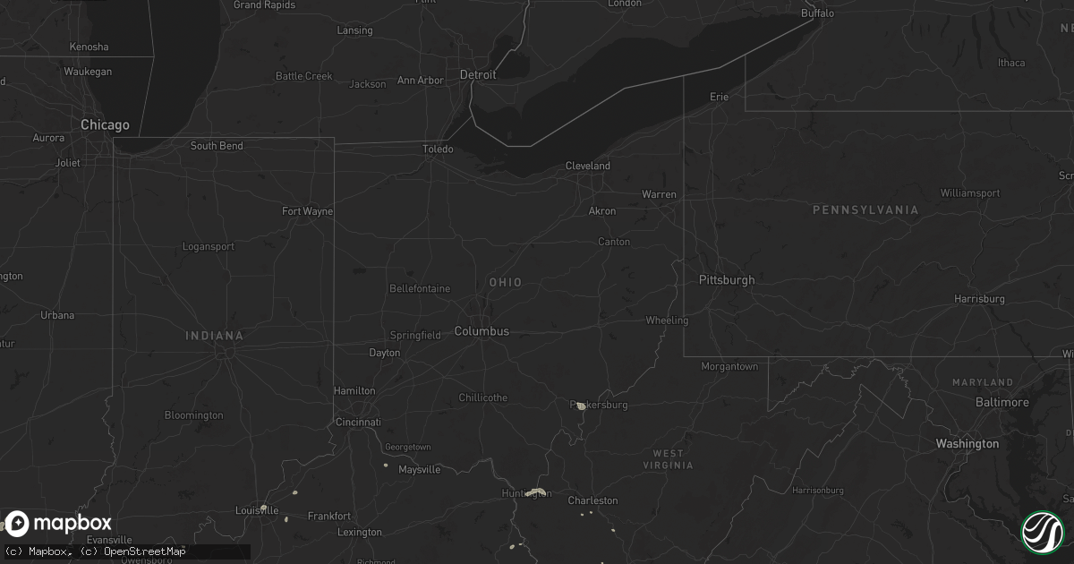
Hail Map in Ohio on July 17, 2025
Get this storm
July 17 map
$229
one time, instant access
Download today. No call, no setup
Keep the $229
Bought the map and want the full workflow? Apply the entire $229 to a subscription within 7 days. None of it is wasted.
Every map, not just this one
This buys you this map. Subscription and you get every map we run, in the markets you choose from a few cities to whole states to nationwide. Plus real-time alerts the moment a storm fires.
Contact data
Name, contact info, occupancy, even credit band for addresses in the footprint. You go from where it hit to who to call.
Become the source they trust
Unlimited branding weather history reports on demand. You already have the documented answer ready for the property owner, and you are the one who showed up with it.
Property data and RoofTrace estimates
Pull up any address you have got, its value and the exact code rules for that jurisdiction, straight from One Click Code. Then RoofTrace estimates the squares, pitch, and roof value, priced the way you price.
Storm reports in Ohio
Ohio
| Date | Description |
|---|---|
| 07/17/20254:31 PM CDT | Tree down into powerlines. Time estimated based on radar. |
| 07/17/20254:23 PM CDT | Tree down in the roadway at the intersection of robinson road and thompson road. Time estimated from radar. |
| 07/17/20254:04 PM CDT | Lines down. Several trees/lines down around albany. Time estimated based on radar. |
| 07/17/20253:59 PM CDT | Lines down. Time estimated based on radar. |
| 07/17/20253:55 PM CDT | Large tree down blocking both lanes of county road 193 at olive branch road. Time estimated from radar. |
| 07/17/20253:33 PM CDT | Tree down. Localized event and estimated based on radar. |
All States Impacted by Hail Map on July 17, 2025
Cities Impacted by Hail Map on July 17, 2025
- Joplin, MT
- Inverness, MT
- Rudyard, MT
- Hingham, MT
- Pendroy, MT
- Conrad, MT
- Valier, MT
- Gildford, MT
- Box Elder, MT
- Choteau, MT
- Brady, MT
- Chinook, MT
- Patten, ME
- Dutton, MT
- Carter, MT
- Hays, MT
- Fort Benton, MT
- Geraldine, MT
- Dodson, MT
- Malta, MT
- Gladstone, NM
- Coffee Creek, MT
- Denton, MT
- Roy, NM
- Zortman, MT
- Lewistown, MT
- Hilger, MT
- Brusett, MT
- Jordan, MT
- Roy, MT
- Grass Range, MT
- Winnett, MT
- Schurz, NV
- Yerington, NV
- Sand Springs, MT
- Cohagen, MT
- Musselshell, MT
- Ingomar, MT
- Saco, MT
- Hinsdale, MT
- Glasgow, MT
- Vandalia, MT
- Forsyth, MT
- Fort Peck, MT
- Nashua, MT
- Angela, MT
- Kinsey, MT
- White Owl, SD
- Howes, SD
- Union Center, SD
- Milesville, SD
- Cherry Creek, SD
- Midland, SD
- Hayes, SD
- Fort Pierre, SD
- Macedonia, IL
- Cedar City, UT
- Tell City, IN
- Paducah, KY
- Palmyra, IN
- Clemmons, NC
- Winston Salem, NC
- Festus, MO
- Marissa, IL
- Sparta, IL
- O'Fallon, IL
- Caseyville, IL
- Collinsville, IL
- Trementina, NM
- Coolville, OH
- Little Hocking, OH
- Pinckneyville, IL
- Canon City, CO
- Howard, CO
- Red Bud, IL
- New Athens, IL
- Lenzburg, IL
- Bennett, NC
- Springer, NM
- De Soto, MO
- Chester, MT
- Galata, MT
- Lothair, MT
- Alexandria, LA
- Custer, MT
- Hanover, IN
- Roundup, MT
- Glenview, KY
- Louisville, KY
- Leavenworth, IN
- Jeffersonville, IN
- Mount Vernon, IN
- Ewing, IL
- Fort Myers, FL
- Lehigh Acres, FL
- Benton, IL
- Sesser, IL
- Oceana, WV
- Worden, MT
- Abingdon, VA
- Lebanon, VA
- Mayodan, NC
- Sandy Ridge, NC
- Stoneville, NC
- Tennyson, IN
- Troy, IL
- Moneta, VA
- Cannelton, IN
- Troy, IN
- Shelby, MT
- Colorado Springs, CO
- Leopold, IN
- English, IN
- Watrous, NM
- Lake Placid, FL
- Cape Coral, FL
- Kremlin, MT
- Havre, MT
- Smithfield, KY
- La Grange, KY
- Pueblo, CO
- Ina, IL
- Spring Hill, FL
- Ocate, NM
- Corbin, KY
- Barboursville, WV
- Ona, WV
- La Veta, CO
- Bloomsdale, MO
- Eskdale, WV
- Belle Rive, IL
- Bonnie, IL
- Louisa, KY
- Wagon Mound, NM
- Penrose, CO
- Ledger, MT
- Hendersonville, TN
- Mount Juliet, TN
- Elizabethtown, IL
- Golconda, IL
- Burna, KY
- Smithland, KY
- Prairie Du Rocher, IL
- Saint Jacob, IL
- Edwardsville, IL
- Inez, KY
- Alum Creek, WV
- Pecos, NM
- Mebane, NC
- Graham, NC
- Floweree, MT
- Hedley, TX
- Whittington, IL
- Huntington, WV
- Finchville, KY
- Simpsonville, KY
- Fisherville, KY
- Garita, NM
- Las Vegas, NM
- Hartford, KY
- Pendleton, KY
- Roswell, NM
- Fort Sumner, NM
- Puryear, TN
- Hillsborough, NC
- Chapel Hill, NC
- Durham, NC
- Tampa, FL
- Lutz, FL
- Moore Haven, FL
- Labelle, FL
- Brooksville, KY
- Foster, KY
- Inglis, FL
- Whitley City, KY
- Pine Knot, KY
- Stearns, KY
- Proctorville, OH
- Lakeview, TX
- Highwood, MT
- Alva, FL
- Solano, NM
- Baldwin, IL
- Charleston, WV
- Tucumcari, NM
- Parrottsville, TN
- Murray, KY
- Dexter, NM
- Canyon, TX
- Mosquero, NM
- Hazel, KY
- Boonville, IN
- Strunk, KY
- Richland, MT
- Larslan, MT
- Venus, FL
- Dover, TN
- Peerless, MT
- Rosebud, MT
- San Jon, NM
- Stratford, TX
- Dalhart, TX
- Clarksville, IN
- Lexington, IN
- Newell, SD
- Belle Fourche, SD
- Enning, SD
- Mud Butte, SD
- New Harmony, IN
- Wall, SD
- Hawesville, KY
- Henderson, KY
- Boaz, KY
- Brooksville, FL
- Memphis, TN


