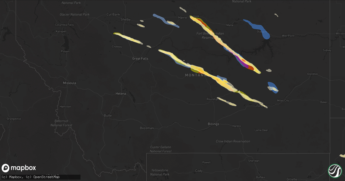
Hail Map in Montana on July 17, 2025
Get this storm
July 17 map
$229
one time, instant access
Download today. No call, no setup
Keep the $229
Bought the map and want the full workflow? Apply the entire $229 to a subscription within 7 days. None of it is wasted.
Every map, not just this one
This buys you this map. Subscription and you get every map we run, in the markets you choose from a few cities to whole states to nationwide. Plus real-time alerts the moment a storm fires.
Contact data
Name, contact info, occupancy, even credit band for addresses in the footprint. You go from where it hit to who to call.
Become the source they trust
Unlimited branding weather history reports on demand. You already have the documented answer ready for the property owner, and you are the one who showed up with it.
Property data and RoofTrace estimates
Pull up any address you have got, its value and the exact code rules for that jurisdiction, straight from One Click Code. Then RoofTrace estimates the squares, pitch, and roof value, priced the way you price.
Storm reports in Montana
Montana
| Date | Description |
|---|---|
| 07/17/20255:28 PM CDT | Ambient weather station. |
| 07/17/20255:28 PM CDT | A |
| 07/17/20255:13 PM CDT | Peak wind gust of 52 |
| 07/17/20255:13 PM CDT | Peak wind gust of 52 mph resulted in a tree branch of 6 to 12 inches in diameter breaking off. Hail was the size of nickels. |
| 07/17/20254:30 PM CDT | A local report indicates 58 MPH wind near 2 E Inverness |
| 07/16/202511:00 PM CDT | Mesonet station mthil 1.6 nw rock springs |
| 07/16/202510:00 PM CDT | Mosby s |
| 07/16/20259:50 PM CDT | A local report indicates 1.75 inch wind near 13 ESE Winnett |
| 07/16/20259:50 PM CDT | A local report indicates 60 MPH wind near 13 ESE Winnett |
| 07/16/20259:30 PM CDT | Mdt dot site in mt 200 at mp 136. |
| 07/16/20259:30 PM CDT | A local report indicates 60 MPH wind near 8 SE Winnett |
| 07/16/20259:20 PM CDT | A local report indicates 2.00 inch wind near 6 WSW Petrolia Lake |
| 07/16/20259:10 PM CDT | Destroyed raingage. |
| 07/16/20259:05 PM CDT | Hen egg sized hail damaged windshields of 6 vehicles and completely broke out 2 house windows. |
| 07/16/20257:50 PM CDT | Mul |
| 07/16/20257:50 PM CDT | Multiple 6-inch diameter tree limbs broken off. 0.75 inch of rain in 15 minutes. |
| 07/16/20257:35 PM CDT | Estimated hail size from mt dot web cam image at mp 121 on us 191. |
| 07/16/20257:02 PM CDT | Ambient weather station stone windmil measured a 63 mph gust. |
All States Impacted by Hail Map on July 17, 2025
Cities Impacted by Hail Map on July 17, 2025
- Joplin, MT
- Inverness, MT
- Rudyard, MT
- Hingham, MT
- Pendroy, MT
- Conrad, MT
- Valier, MT
- Gildford, MT
- Box Elder, MT
- Choteau, MT
- Brady, MT
- Chinook, MT
- Patten, ME
- Dutton, MT
- Carter, MT
- Hays, MT
- Fort Benton, MT
- Geraldine, MT
- Dodson, MT
- Malta, MT
- Gladstone, NM
- Coffee Creek, MT
- Denton, MT
- Roy, NM
- Zortman, MT
- Lewistown, MT
- Hilger, MT
- Brusett, MT
- Jordan, MT
- Roy, MT
- Grass Range, MT
- Winnett, MT
- Schurz, NV
- Yerington, NV
- Sand Springs, MT
- Cohagen, MT
- Musselshell, MT
- Ingomar, MT
- Saco, MT
- Hinsdale, MT
- Glasgow, MT
- Vandalia, MT
- Forsyth, MT
- Fort Peck, MT
- Nashua, MT
- Angela, MT
- Kinsey, MT
- White Owl, SD
- Howes, SD
- Union Center, SD
- Milesville, SD
- Cherry Creek, SD
- Midland, SD
- Hayes, SD
- Fort Pierre, SD
- Macedonia, IL
- Cedar City, UT
- Tell City, IN
- Paducah, KY
- Palmyra, IN
- Clemmons, NC
- Winston Salem, NC
- Festus, MO
- Marissa, IL
- Sparta, IL
- O'Fallon, IL
- Caseyville, IL
- Collinsville, IL
- Trementina, NM
- Coolville, OH
- Little Hocking, OH
- Pinckneyville, IL
- Canon City, CO
- Howard, CO
- Red Bud, IL
- New Athens, IL
- Lenzburg, IL
- Bennett, NC
- Springer, NM
- De Soto, MO
- Chester, MT
- Galata, MT
- Lothair, MT
- Alexandria, LA
- Custer, MT
- Hanover, IN
- Roundup, MT
- Glenview, KY
- Louisville, KY
- Leavenworth, IN
- Jeffersonville, IN
- Mount Vernon, IN
- Ewing, IL
- Fort Myers, FL
- Lehigh Acres, FL
- Benton, IL
- Sesser, IL
- Oceana, WV
- Worden, MT
- Abingdon, VA
- Lebanon, VA
- Mayodan, NC
- Sandy Ridge, NC
- Stoneville, NC
- Tennyson, IN
- Troy, IL
- Moneta, VA
- Cannelton, IN
- Troy, IN
- Shelby, MT
- Colorado Springs, CO
- Leopold, IN
- English, IN
- Watrous, NM
- Lake Placid, FL
- Cape Coral, FL
- Kremlin, MT
- Havre, MT
- Smithfield, KY
- La Grange, KY
- Pueblo, CO
- Ina, IL
- Spring Hill, FL
- Ocate, NM
- Corbin, KY
- Barboursville, WV
- Ona, WV
- La Veta, CO
- Bloomsdale, MO
- Eskdale, WV
- Belle Rive, IL
- Bonnie, IL
- Louisa, KY
- Wagon Mound, NM
- Penrose, CO
- Ledger, MT
- Hendersonville, TN
- Mount Juliet, TN
- Elizabethtown, IL
- Golconda, IL
- Burna, KY
- Smithland, KY
- Prairie Du Rocher, IL
- Saint Jacob, IL
- Edwardsville, IL
- Inez, KY
- Alum Creek, WV
- Pecos, NM
- Mebane, NC
- Graham, NC
- Floweree, MT
- Hedley, TX
- Whittington, IL
- Huntington, WV
- Finchville, KY
- Simpsonville, KY
- Fisherville, KY
- Garita, NM
- Las Vegas, NM
- Hartford, KY
- Pendleton, KY
- Roswell, NM
- Fort Sumner, NM
- Puryear, TN
- Hillsborough, NC
- Chapel Hill, NC
- Durham, NC
- Tampa, FL
- Lutz, FL
- Moore Haven, FL
- Labelle, FL
- Brooksville, KY
- Foster, KY
- Inglis, FL
- Whitley City, KY
- Pine Knot, KY
- Stearns, KY
- Proctorville, OH
- Lakeview, TX
- Highwood, MT
- Alva, FL
- Solano, NM
- Baldwin, IL
- Charleston, WV
- Tucumcari, NM
- Parrottsville, TN
- Murray, KY
- Dexter, NM
- Canyon, TX
- Mosquero, NM
- Hazel, KY
- Boonville, IN
- Strunk, KY
- Richland, MT
- Larslan, MT
- Venus, FL
- Dover, TN
- Peerless, MT
- Rosebud, MT
- San Jon, NM
- Stratford, TX
- Dalhart, TX
- Clarksville, IN
- Lexington, IN
- Newell, SD
- Belle Fourche, SD
- Enning, SD
- Mud Butte, SD
- New Harmony, IN
- Wall, SD
- Hawesville, KY
- Henderson, KY
- Boaz, KY
- Brooksville, FL
- Memphis, TN


