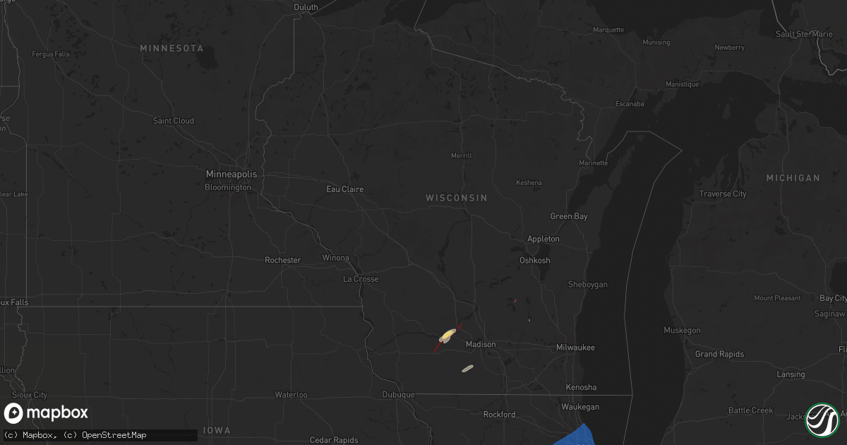
Hail Map in Wisconsin on July 16, 2025
Get this storm
July 16 map
$229
one time, instant access
Download today. No call, no setup
Keep the $229
Bought the map and want the full workflow? Apply the entire $229 to a subscription within 7 days. None of it is wasted.
Every map, not just this one
This buys you this map. Subscription and you get every map we run, in the markets you choose from a few cities to whole states to nationwide. Plus real-time alerts the moment a storm fires.
Contact data
Name, contact info, occupancy, even credit band for addresses in the footprint. You go from where it hit to who to call.
Become the source they trust
Unlimited branding weather history reports on demand. You already have the documented answer ready for the property owner, and you are the one who showed up with it.
Property data and RoofTrace estimates
Pull up any address you have got, its value and the exact code rules for that jurisdiction, straight from One Click Code. Then RoofTrace estimates the squares, pitch, and roof value, priced the way you price.
Storm reports in Wisconsin
Wisconsin
| Date | Description |
|---|---|
| 07/16/20255:37 PM CDT | Multiple reports of trees and large branches down as well as a power pole on fire. |
| 07/16/20254:00 PM CDT | Trees down and uprooted. Garbage bins blown 75 yards. Pea size hail. Estimated winds of 60 mph. |
| 07/16/20253:52 PM CDT | Power |
| 07/16/20253:52 PM CDT | Power is out in the area. |
| 07/16/20253:35 PM CDT | A local report indicates a tornado near 2 NW Hustisford |
| 07/16/20253:26 PM CDT | Multiple trees down. |
| 07/16/20253:22 PM CDT | Nws surv |
| 07/16/20253:22 PM CDT | Nws survey crew estimates 70 mph downburst winds based on three pine trees snapped and surrounding minor tree damage. |
| 07/16/20253:22 PM CDT | Nws s |
| 07/16/20253:22 PM CDT | Nws survey team confirms ef-0 tornado with estimated winds of 70 mph starting near the intersection of county road e and w hillcrest rd southwest of hustisford around 3 |
| 07/16/20253:22 PM CDT | Nws sur |
| 07/16/20253:19 PM CDT | Public report & photographs of tree damage off wi-78 in the wi dnr black hawk ridge unit. Time estimated via radar data. |
| 07/16/20253:17 PM CDT | Nws survey crew estimates 60 mph downburst winds based on minor tree damage in the midnight sun dr neighborhood. |
| 07/16/20253:16 PM CDT | Two large branches broken off a 10 year old tree. |
| 07/16/20253:10 PM CDT | Video from us hwy 151 looking w. |
| 07/16/20252:59 PM CDT | Nws survey crew confirms a brief ef-0 tornado with estimated winds around 65 mph in corn fields and tree lines near buckhorn rd and breezy point rd. This tornado starte |
| 07/16/20252:55 PM CDT | Corrects previous tstm wnd dmg report from richford. Multiple trees down. The time of this report is an estimate based on radar data. |
| 07/16/20251:29 PM CDT | Video relayed via social media of brief tornado crossing i-90 just southeast of mauston around mm 72.6. |
| 07/16/20251:26 PM CDT | Crossing wi hwy 78. |
| 07/16/20251:15 PM CDT | Nws storm survey confirms an ef0 tornado beginning near the intersection of racek rd and wi-78. Max wind speed 80 mph... With tree & shingle damage noted. Beginning tim |
| 07/16/202512:40 PM CDT | Delayed report: tree damage near intersection of griffiths road and co hwy zz. Possible tornado damage pending survey. |
| 07/16/202512:30 PM CDT | Confirmed via county em. |
| 07/16/202512:24 PM CDT | Nws storm survey confirms an ef-1 beginning near the intersection of hwy yz and z... Northeast of dodgeville around 12:24 pm and ending near knobs rd around southwest o |
All States Impacted by Hail Map on July 16, 2025
Cities Impacted by Hail Map on July 16, 2025
- Valentine, NE
- Thedford, NE
- Halsey, NE
- Tryon, NE
- Stapleton, NE
- Purdum, NE
- Dunning, NE
- Arnold, NE
- Dodgeville, WI
- Spring Green, WI
- Ridgeway, WI
- Arena, WI
- Barneveld, WI
- Mazomanie, WI
- Sauk City, WI
- Belleville, WI
- Tiskilwa, IL
- Princeton, IL
- Hennepin, IL
- Granville, IL
- Peru, IL
- Depue, IL
- Spring Valley, IL
- La Salle, IL
- Utica, IL
- Oglesby, IL
- Ottawa, IL
- Dalzell, IL
- Mendota, IL
- Earlville, IL
- Leland, IL
- Serena, IL
- Sheridan, IL
- Wedron, IL
- Marseilles, IL
- Seneca, IL
- Newark, IL
- Millington, IL
- Yorkville, IL
- Sandwich, IL
- Streator, IL
- Grand Ridge, IL
- Ransom, IL
- Verona, IL
- Morris, IL
- Minooka, IL
- Lost City, WV
- Wardensville, WV
- Jacksonville, IL
- Blue Mounds, WI
- Pleasant Plains, IL
- Joliet, IL
- Shorewood, IL
- Plainfield, IL
- Lockport, IL
- Oswego, IL
- Crest Hill, IL
- Mazon, IL
- Coal City, IL
- El Paso, IL
- Success, AR
- Annada, MO
- Elsberry, MO
- Doniphan, MO
- Oxly, MO
- Maynard, AR
- Greenville, MO
- Naylor, MO
- Manitou Springs, CO
- Colorado Springs, CO
- Montgomery, IL
- Naperville, IL
- Aurora, IL
- Homer Glen, IL
- Romeoville, IL
- Bolingbrook, IL
- Palos Heights, IL
- Darien, IL
- Palos Park, IL
- Lemont, IL
- Downers Grove, IL
- Woodridge, IL
- Lisle, IL
- Orland Park, IL
- Westmont, IL
- Warrenville, IL
- Lombard, IL
- Willow Springs, IL
- Wheaton, IL
- Glen Ellyn, IL
- Willowbrook, IL
- Palos Hills, IL
- Oak Brook, IL
- Hickory Hills, IL
- Worth, IL
- Clarendon Hills, IL
- La Grange, IL
- Villa Park, IL
- Bridgeview, IL
- Western Springs, IL
- Summit Argo, IL
- Hinsdale, IL
- Justice, IL
- La Grange Park, IL
- Brookfield, IL
- Channahon, IL
- Wilmington, IL
- Elwood, IL
- New Lenox, IL
- Manhattan, IL
- Gridley, IL
- Flanagan, IL
- Yellow Spring, WV
- Midlothian, IL
- Hometown, IL
- Chicago Ridge, IL
- Riverdale, IL
- Crestwood, IL
- Robbins, IL
- Evergreen Park, IL
- Alsip, IL
- Chicago, IL
- Lyons, IL
- Burbank, IL
- Blue Island, IL
- Oak Lawn, IL
- Riverside, IL
- Westchester, IL
- Hillside, IL
- Berwyn, IL
- Broadview, IL
- Addison, IL
- Glendale Heights, IL
- Elmhurst, IL
- Berkeley, IL
- Cicero, IL
- River Grove, IL
- Oak Park, IL
- Bellwood, IL
- Wood Dale, IL
- Stone Park, IL
- Bensenville, IL
- Franklin Park, IL
- Maywood, IL
- Schiller Park, IL
- Hines, IL
- River Forest, IL
- Forest Park, IL
- Melrose Park, IL
- Plano, IL
- Millbrook, IL
- Sugar Grove, IL
- Bristol, IL
- Geneva, IL
- Mooseheart, IL
- Batavia, IL
- North Aurora, IL
- Wayne, IL
- Bartlett, IL
- West Chicago, IL
- Saint Charles, IL
- Elk Grove Village, IL
- Schaumburg, IL
- Itasca, IL
- Hoffman Estates, IL
- Arlington Heights, IL
- Medinah, IL
- Streamwood, IL
- Winfield, IL
- Hanover Park, IL
- Roselle, IL
- Rolling Meadows, IL
- Bloomingdale, IL
- Mount Prospect, IL
- Carol Stream, IL
- Des Plaines, IL
- Palatine, IL
- Elmwood Park, IL
- Niles, IL
- Harwood Heights, IL
- Park Ridge, IL
- Glenview, IL
- Wheeling, IL
- Northbrook, IL
- Prospect Heights, IL
- Fox Lake, WI
- Raton, NM
- Rollinsville, CO
- Black Hawk, CO
- Brooklyn, WI
- Silex, MO
- Livermore, CO
- Pontiac, IL
- Hustisford, WI
- Morton Grove, IL
- Lincolnwood, IL
- Skokie, IL
- Golf, IL
- Evanston, IL
- Wilmette, IL
- Winnetka, IL
- Glencoe, IL
- Highland Park, IL
- Kenilworth, IL
- Bloomington, IL
- Carlock, IL
- Normal, IL
- Hudson, IL
- Towanda, IL
- Danvers, IL
- Downs, IL
- Ellsworth, IL
- Cooksville, IL
- Fairbury, IL
- Saunemin, IL
- Forrest, IL
- Golden, CO
- Cross Junction, VA
- Sedalia, CO
- Fieldon, IL
- Emington, IL
- Eolia, MO
- Troy, MO
- Cameron, NC
- Buckingham, IL
- Cabery, IL
- Castle Rock, CO
- Jerseyville, IL
- Medora, IL
- Reddick, IL
- Dwight, IL
- Yellville, AR
- Foley, MO
- Hardin, IL
- Brussels, IL
- Batchtown, IL
- Sanford, NC
- Campbell, MO
- Chesterfield, IL
- Morrisonville, IL
- Kaibeto, AZ
- Grafton, IL
- Berkeley Springs, WV
- Winchester, VA
- Herron, MI
- Lachine, MI
- Carpenter, WY
- Taylorville, IL
- Assumption, IL
- Wellington, CO
- Fort Collins, CO
- Grover, CO
- Palmer, IL
- Hardin, MO
- Clay City, IL
- Louisville, IL
- Big Pool, MD
- Clear Spring, MD
- Owaneco, IL
- Nunn, CO
- Flora, IL
- Franktown, CO
- Dow, IL
- Elsah, IL
- Elbert, CO
- Larkspur, CO
- Hedgesville, WV
- Pierce, CO
- Mokena, IL
- Oak Forest, IL
- Flossmoor, IL
- South Holland, IL
- Posen, IL
- Harvey, IL
- Hazel Crest, IL
- Calumet City, IL
- Tinley Park, IL
- Lansing, IL
- Dolton, IL
- Homewood, IL
- Chicago Heights, IL
- Country Club Hills, IL
- Glenwood, IL
- Thornton, IL
- Markham, IL
- East Chicago, IN
- Hammond, IN
- Whiting, IN
- Munster, IN
- Gary, IN
- Highland, IN
- Dyer, IN
- Merrillville, IN
- Schererville, IN
- Griffith, IN
- Crown Point, IN
- Wanatah, IN
- Hobart, IN
- Lake Station, IN
- Hebron, IN
- Chesterton, IN
- Valparaiso, IN
- Portage, IN
- Westville, IN
- Ingraham, IL
- Noble, IL
- Nekoma, KS
- Rush Center, KS
- Staunton, IL
- Warrenton, MO
- Truxton, MO
- Hawk Point, MO
- Philo, IL
- Villa Grove, IL
- Westcliffe, CO
- Olney, IL
- Fountain, CO
- La Porte, IN
- Michigan City, IN
- Union Mills, IN
- Beverly Shores, IN
- Dundas, IL
- Fillmore, IL
- Glasgow, MO
- Orrick, MO
- Briggsdale, CO
- Coffeen, IL
- Bingham, IL
- Mars, PA
- Warrendale, PA
- Wexford, PA
- Baden, PA
- Bradfordwoods, PA
- Cranberry Township, PA
- Des Moines, NM
- Capulin, NM
- Springer, NM
- Rozel, KS
- Ramsey, IL
- Wetmore, CO
- Upper Tract, WV
- Buford, WY
- Monticello, WI
- New Glarus, WI
- Allison Park, PA
- Gibsonia, PA
- Ranson, WV
- Kearneysville, WV
- Charles Town, WV
- Summit Point, WV
- Pittsburgh, PA
- Glenshaw, PA
- New Carlisle, IN
- Mill Creek, IN
- Rolling Prairie, IN
- Monon, IN
- Winamac, IN
- Francesville, IN
- Monticello, IN
- Star City, IN
- Beulah, CO
- Pueblo, CO
- Buffalo, IN
- Royal Center, IN
- Burnettsville, IN
- Kewanna, IN
- Burdett, KS
- Bentonville, VA
- Armstrong, MO
- Salisbury, MO
- Mulberry Grove, IL
- Vandalia, IL
- Harpers Ferry, WV
- Cheswick, PA
- Bairdford, PA
- Purgitsville, WV
- Romney, WV
- Russellton, PA
- Tarentum, PA
- Bakerstown, PA
- Cheyenne, WY
- Stoneham, CO
- Shobonier, IL
- Brownstown, IL
- Huntly, VA
- Berryville, VA
- Saint Elmo, IL
- Purcellville, VA
- Sewickley, PA
- Zelienople, PA
- Evans City, PA
- Hanston, KS
- Watson, IL
- Effingham, IL
- Snyder, CO
- Chester Gap, VA
- Flint Hill, VA
- Franklin, WV
- Altamont, IL
- Beecher City, IL
- Mason, IL
- Vernon, IL
- Alma, IL
- Alexander, KS
- High View, WV
- Patoka, IL
- New Raymer, CO
- Waterford, VA
- Lovettsville, VA
- Rye, CO
- Delray, WV
- Augusta, WV
- Larned, KS
- Kinsley, KS
- Millville, WV
- Merino, CO
- Bluemont, VA
- Martinsville, IL
- Higbee, MO
- Gardner, CO
- Annapolis, IL
- Casey, IL
- Wheeler, IL
- New Ross, IN
- Crawfordsville, IN
- Kinmundy, IL
- Moberly, MO
- Madison, MO
- Colorado City, CO
- Keytesville, MO
- Leesburg, VA
- Paeonian Springs, VA
- Hamilton, VA
- Akron, CO
- Hillrose, CO
- Clifton Hill, MO
- Marshall, VA
- Dieterich, IL
- Newton, IL
- Addison, NY
- Folsom, NM
- Huntsville, MO
- Millstone Township, NJ
- Walsenburg, CO
- Spearville, KS
- Jetmore, KS
- The Plains, VA
- Warrenton, VA
- Bluford, IL
- Valencia, PA
- Timberville, VA
- New Market, VA
- Broadway, VA
- Wright, KS
- Grenville, NM
- Ashley, IL
- Du Bois, IL
- Richview, IL
- Woodlawn, IL
- Keenes, IL
- Centralia, IL
- Broad Run, VA
- Lucerne, IN
- Dodge City, KS
- Brunswick, MO
- Avondale, CO
- Jasonville, IN
- Fulks Run, VA
- Riverside, MO
- Kansas City, MO
- Kansas City, KS
- Luray, VA
- Stanley, VA
- Cisne, IL
- Milliken, CO
- Fowler, CO
- Model, CO
- Slater, MO
- Dalton, MO
- Minneola, KS
- Johnstown, CO
- Bowling Green, MO
- Middletown, MO
- Ensign, KS
- Fowler, KS
- Montezuma, KS
- Meade, KS
- Plains, KS
- Philippi, WV
- Moatsville, WV
- Flemington, WV
- Parsons, WV
- Rowlesburg, WV
- Tunnelton, WV
- Terra Alta, WV
- Aurora, WV
- Thornton, WV
- Oakland, MD
- Nanty Glo, PA
- Ebensburg, PA
- Loretto, PA
- Gallitzin, PA
- Ashville, PA
- Dysart, PA
- Chest Springs, PA
- Fallentimber, PA
- Patton, PA
- Fe Warren Afb, WY
- Olathe, KS
- Gardner, KS
- New Century, KS
- Smithville, MO
- Johnson, KS
- Ulysses, KS
- Harveyville, KS
- Auburn, KS
- Paxico, KS
- Maple Hill, KS
- Eskridge, KS
- Topeka, KS
- Alma, KS
- Allen, KS
- Reading, KS
- Admire, KS
- Burlingame, KS
- Wakarusa, KS
- Carbondale, KS
- Osage City, KS
- Scranton, KS
- Silver Lake, KS
- Emmett, KS
- Belvue, KS
- Onaga, KS
- Delia, KS
- Saint Marys, KS
- McFarland, KS
- Wamego, KS
- Rossville, KS
- Saint George, KS
- Westmoreland, KS
- Lebo, KS
- Lyndon, KS
- Melvern, KS
- Waverly, KS
- Wellsville, KS
- Rantoul, KS
- Ottawa, KS
- Princeton, KS
- Williamsburg, KS
- Vassar, KS
- Pomona, KS
- Quenemo, KS
- Overbrook, KS
- Garnett, KS
- Westphalia, KS
- Richmond, KS
- Welda, KS
- Paola, KS
- Greeley, KS
- Osawatomie, KS
- Lane, KS
- Parker, KS
- Centerville, KS
- Fontana, KS
- Amity, MO
- Sweet Springs, MO
- Faucett, MO
- Agency, MO
- Hebron, NE
- Gilead, NE
- Independence, MO
- Fayette, MO
- Malta Bend, MO
- Blackburn, MO
- Selden, KS
- Nelson, MO
- Marshall, MO
- King City, MO
- Union Star, MO
- Fairbury, NE
- Alexandria, NE
- Nettie, WV
- Rocky Ford, CO
- Dearborn, MO
- Hoxie, KS
- Clarksdale, MO
- Cosby, MO
- Helena, MO
- Maysville, MO
- Gilliam, MO
- Cameron, MO
- Miami, MO
- Tecumseh, NE
- Brock, NE
- Johnson, NE
- Cook, NE
- Columbia, MO
- Lebanon, KS
- Holly, CO
- Boonville, MO
- Hunter, KS
- Shipman, IL
- Bonner Springs, KS
- Shawnee, KS
- Lenexa, KS
- Syracuse, KS
- Wakeeney, KS
- Gillespie, IL
- Bucklin, MO
- Beloit, KS
- Agra, KS
- Phillipsburg, KS
- Lakin, KS
- Kensington, KS
- De Kalb, MO
- Saint Joseph, MO
- Winfield, MO
- Brashear, MO
- Kirksville, MO
- Hugoton, KS
- Goodwell, OK
- Golden Eagle, IL
- Piasa, IL
- Stewartsville, MO
- Talmage, NE
- La Plata, MO
- Godfrey, IL
- Mosquero, NM
- Bunker Hill, IL
- Auburn, NE
- Mount Olive, IL
- Brighton, IL
- O'Fallon, MO
- Dorsey, IL
- Wood River, IL
- Bethalto, IL
- Moro, IL
- Alton, IL
- East Alton, IL
- Cottage Hills, IL
- Benld, IL
- New Douglas, IL
- Carlinville, IL
- Livingston, IL
- Edwardsville, IL
- Wilsonville, IL
- Alhambra, IL
- Sawyerville, IL
- Worden, IL
- West Alton, MO
- Portage Des Sioux, MO
- Mayview, MO
- Lexington, MO
- Bucyrus, KS
- Spring Hill, KS
- Louisburg, KS
- Saint Charles, MO
- Edgerton, KS
- Walnut Hill, IL
- Henrietta, MO
- Higginsville, MO
- Moscow Mills, MO
- Jonesburg, MO
- Overland Park, KS
- Sandoval, IL
- Hoyleton, IL
- Hamburg, IL


